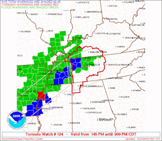
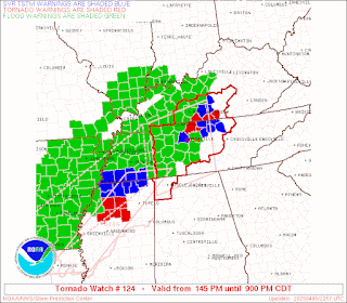
While this is serious for the areas affected, this is not the main event, which is still expected to come either late this evening or overnight into tomorrow morning for the majority of North Alabama, stretching into Southern Middle Tennessee. As long as this system has dragged on, need to save energy for when things do affect the I-65 corridor as it's often called. But just popping on to acknowledge this activity for now.
5:58 PM - Looks like this line of storms will get to Northwest Alabama around Midnight. There have been some isolated storms that went severe this evening mainly up in Middle Tennessee, including the city of Nashville at one point. And I think a "hailer" storm that affected Colbert, Franklin, and Lawrence Counties in Northwest Alabama. As I said before, based on past experience with this system, I'm saving my energy for the main event overnight tonight. The window for severe weather for most of us is probably about from 11 PM to 8 AM with this system.
SEL4
URGENT - IMMEDIATE BROADCAST REQUESTED
Tornado Watch Number 124
NWS Storm Prediction Center Norman OK
145 PM CDT Sat Apr 5 2025
The NWS Storm Prediction Center has issued a
* Tornado Watch for portions of
Northwest Alabama
Southern Kentucky
Western and Middle Tennessee
* Effective this Saturday afternoon and evening from 145 PM until
900 PM CDT.
* Primary threats include...
A few tornadoes and a couple intense tornadoes possible
Widespread damaging winds likely with isolated significant gusts
to 75 mph possible
Isolated large hail events to 1.5 inches in diameter possible
SUMMARY...A well-organized bow echo will continue east-northeastward
this afternoon, while other semi-discrete supercells may develop
ahead of it, and southward into the warm sector.
The tornado watch area is approximately along and 80 statute miles
north and south of a line from 65 miles north northwest of Muscle
Shoals AL to 55 miles east of Nashville TN. For a complete depiction
of the watch see the associated watch outline update (WOUS64 KWNS
WOU4).
PRECAUTIONARY/PREPAREDNESS ACTIONS...
REMEMBER...A Tornado Watch means conditions are favorable for
tornadoes and severe thunderstorms in and close to the watch
area. Persons in these areas should be on the lookout for
threatening weather conditions and listen for later statements
and possible warnings.
&&
OTHER WATCH INFORMATION...CONTINUE...WW 122...WW 123...
AVIATION...Tornadoes and a few severe thunderstorms with hail
surface and aloft to 1.5 inches. Extreme turbulence and surface wind
gusts to 65 knots. A few cumulonimbi with maximum tops to 500. Mean
storm motion vector 23040.
...Guyer
WOUS64 KWNS 051841
WOU4
BULLETIN - IMMEDIATE BROADCAST REQUESTED
TORNADO WATCH OUTLINE UPDATE FOR WT 124
NWS STORM PREDICTION CENTER NORMAN OK
145 PM CDT SAT APR 5 2025
TORNADO WATCH 124 IS IN EFFECT UNTIL 900 PM CDT FOR THE
FOLLOWING LOCATIONS
ALC033-059-077-060200-
/O.NEW.KWNS.TO.A.0124.250405T1845Z-250406T0200Z/
AL
. ALABAMA COUNTIES INCLUDED ARE
COLBERT FRANKLIN LAUDERDALE
KYC003-009-031-035-047-057-061-141-169-171-177-213-219-221-227-
060200-
/O.NEW.KWNS.TO.A.0124.250405T1845Z-250406T0200Z/
KY
. KENTUCKY COUNTIES INCLUDED ARE
ALLEN BARREN BUTLER
CALLOWAY CHRISTIAN CUMBERLAND
EDMONSON LOGAN METCALFE
MONROE MUHLENBERG SIMPSON
TODD TRIGG WARREN
TNC003-015-021-027-031-037-041-043-055-081-083-085-087-099-101-
111-117-119-125-133-135-141-147-149-159-161-165-169-175-177-181-
185-187-189-060200-
/O.NEW.KWNS.TO.A.0124.250405T1845Z-250406T0200Z/
TN
. TENNESSEE COUNTIES INCLUDED ARE
BEDFORD CANNON CHEATHAM
CLAY COFFEE DAVIDSON
DE KALB DICKSON GILES
HICKMAN HOUSTON HUMPHREYS
JACKSON LAWRENCE LEWIS
MACON MARSHALL MAURY
MONTGOMERY OVERTON PERRY
PUTNAM ROBERTSON RUTHERFORD
SMITH STEWART SUMNER
TROUSDALE VAN BUREN WARREN
WAYNE WHITE WILLIAMSON
WILSON
ATTN...WFO...HUN...OHX...LMK...PAH...


No comments:
Post a Comment