


Be sheltered anywhere in this polygon, even if the rotation looks like it's just East of Waynesboro at the moment.

9:13 PM - They draw these large polygons for a reason. There is margin for error with radar, tornadoes are tough to confirm at night, plus tornadoes can change direction quickly. So they're covering everywhere that might be affected by this possible tornado. And the whole storm is dangerous, even the parts with just strong winds and hail, lots of lightning, heavy rain . . .
People from Waynesboro and Collinwood all the way through Westpoint and over to Lawrenceburg need to be in their tornado shelter. The main thing is to be out of a mobile home and sheltering in a sturdy house or other strong building - small room or hallway on the lowest floor, away from windows and near the center of the building - some walls between you and the outside.

9:20 - This is interesting though, the rotation is riding the Northern end of this polygon and trying to venture outside it to the North a little.

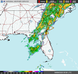
9:23 - That was from the Hytop radar. Now from the Old Hickory radar, you can see what I mean about there being a margin for error with even our super-duper dual-pol radars these days. And at night you have to respect warning polygons and not get too hung up on exactly where a tornado might be developing or happening, just play it safe.

9:30 - That severe thunderstorm warning for Colbert and Lauderdale County was allowed to expire on time. The tornado warning for Lawrence County and Eastern Wayne County in Tennessee remains in effect until 10:15 PM CDT.
And I know this doesn't look nearly as scary and dramatic as a lot of the confirmed tornado warnings we've had lately. But I would respect the warning and stay in a good safe place until the threat passes. Small room or hallway on the lowest floor of a sturdy house away from windows - some walls between you and the outside if possible. But if you have to shelter in a room toward the edge of the house, try to make it a bathroom - if you have one without windows in it.

9:35 - Okay and this is clearly out of Wayne County now and just an issue for Lawrence County, TN.
Lawrenceburg, Ethridge, all the way up to Summertown and all the way down to Leoma, stay sheltered.

9:38 - And this has been extended into Giles County as a Severe Thunderstorm Warning until 10:30 as the rotation is weakening and looks more likely to produce 60 mph straight-line winds than a tornado anymore. I'd still stay in a good safe place and play it safe with these storms tonight. This storm system has a history of nasty surprises over several days. So I'd respect any warnings and take some level of shelter, don't thumb your nose at it.
This new warning does also clip Marshall, Lewis, and Maury Counties in Middle Tennessee, including the city of Columbia.

9:42 - And we have a new Severe Thunderstorm Warning for Lauderdale, Colbert, and Franklin Counties. This does include Muscle Shoals. This is for 60 mph wind gusts, but some small hail is also possible. And there is enough rotation in this storm that a tornado could quickly develop.
So here too, people need to move to a small interior room or hallway on the lowest floor of a sturdy house or other strong building. Mobile homes are very vulnerable to storms with winds like this, especially if trees are around. And if a tornado were to develop, a tornado can easily turn over or destroy a mobile home. Where the central, lowest parts of a site-built house are usually going to be left standing. It's harder for a tree to fall all the way through those smaller, lower rooms in a frame house too. Those walls that are tighter in together in something like a closet or hallway could protect people from that. But sadly the cheaper construction of mobile homes, the trees usually come all the way through them if they do fall. So just letting you know, it's better if you can shelter in a site-built house for this. And if a tornado were to develop, it'd be an emergency where you would have to get out of the mobile home before the tornado hit. So use your best judgement here.

9:47 - Having said that, the rotation appears to be broadening out compared to when the storms prompted tornado warnings back in Mississippi. But even if these are straight-line winds, I'd hope people had a reasonably safe place to be in the path tonight. I wouldn't stay in a mobile home in the path of these storms if I could help it, would try to be in a sturdier house on the lowest floor, away from windows, in a hallway or smaller room where the walls would be less likely to collapse even if something happened like a tree falling or a window being broken out.
Spoke too soon - they are upgrading to Tornado Warning, got one confirmed in MS . . . new post coming.
218
WFUS54 KOHX 060208
TOROHX
TNC099-181-060315-
/O.NEW.KOHX.TO.W.0060.250406T0208Z-250406T0315Z/
BULLETIN - EAS ACTIVATION REQUESTED
Tornado Warning
National Weather Service Nashville TN
908 PM CDT Sat Apr 5 2025
The National Weather Service in Nashville has issued a
* Tornado Warning for...
Southeastern Wayne County in Middle Tennessee...
Lawrence County in Middle Tennessee...
* Until 1015 PM CDT.
* At 907 PM CDT, a severe thunderstorm capable of producing a tornado
was located near Collinwood, or 9 miles southeast of Waynesboro,
moving east at 35 mph.
HAZARD...Tornado.
SOURCE...Radar indicated rotation.
IMPACT...Flying debris will be dangerous to those caught without
shelter. Mobile homes will be damaged or destroyed.
Damage to roofs, windows, and vehicles will occur. Tree
damage is likely.
* This dangerous storm will be near...
Lawrenceburg around 930 PM CDT.
Other locations impacted by this tornadic thunderstorm include
Ethridge, Henryville, Leoma, and Westpoint.
PRECAUTIONARY/PREPAREDNESS ACTIONS...
TAKE COVER NOW! Move to a basement or an interior room on the lowest
floor of a sturdy building. Avoid windows. If you are outdoors, in a
mobile home, or in a vehicle, move to the closest substantial shelter
and protect yourself from flying debris.
&&
LAT...LON 3531 8787 3540 8757 3540 8752 3541 8751
3542 8745 3546 8745 3546 8733 3545 8732
3543 8721 3530 8721 3529 8723 3528 8721
3523 8722 3520 8721 3520 8722 3517 8722
3516 8720 3510 8722 3501 8784
TIME...MOT...LOC 0207Z 251DEG 31KT 3520 8767
TORNADO...RADAR INDICATED
MAX HAIL SIZE...<.75 IN
$$
40/Sizemore


No comments:
Post a Comment