


Got to jump on this one. It is getting too close to Northwest counties of Alabama like Lauderdale, Colbert, and Franklin, and already affects Hardin County, TN. Folks in Wayne County (TN) need to be getting ready to go through your tornado safety plan if a warning is required upstream. This is a confirmed tornado that has a history of doing damage.

7:47 PM - Here's a look at velocity, couldn't get it from Supercell Wx, had to switch back to Radarscope, which is slower but more accurate. More reliable I meant to say.
7:49 - WAFF 48 is live streaming about this already. And Matt Laubhan has been for a while. They do a good job there at WVTA in MS. It's Chelsea Aaron working this night-time weekend event again in Huntsville. She does a good job too.
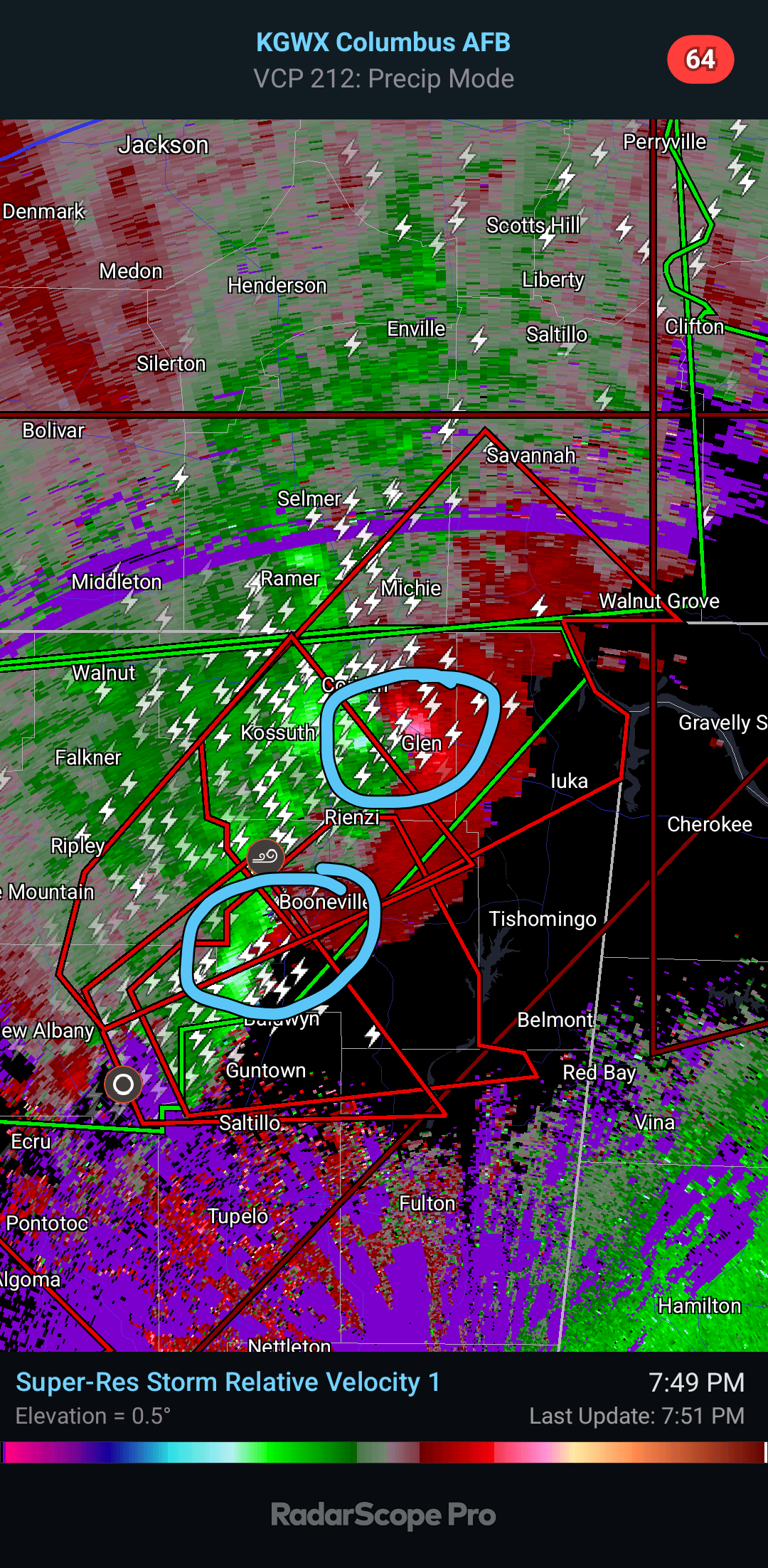
7:51 - Important to realize that we've got two separate tornado circulations here back in North MS. The northern one has been consistently confirmed by people seeing it and then as it got dark, by radar debris signatures.

7:54 - Meanwhile the Tornado Watch is being cancelled out behind the squall line up in Middle Tennessee. Nashville is out of it already.

8 PM - Here's more the broad view. Notice that shower moving Northward in Lawrence and Morgan Counties. Be interesting to see if it does anything when merging with the squall line later. But for now our atmosphere down in Alabama seemed to be staying capped.
Cold front getting close overcomes those capping inversions if the heat of the day doesn't first . . .


8:01 - Tornado Warning issued to include rural Northwestern Lauderdale County.

This is such a small part of the county that it is even Northwest of Waterloo. But if in the path, of course you need to get into a small interior room of a sturdy house, not a mobile home, on the lowest floor.
...A TORNADO WARNING REMAINS IN EFFECT UNTIL 830 PM CDT FOR
NORTHWESTERN LAUDERDALE COUNTY...
At 804 PM CDT, a confirmed tornado was located over Pineflat, or
near Pickwick Landing State Park, moving northeast at 45 mph. Law
enforcement in Mississippi reported a tornado north of Burnsville,
MS.
HAZARD...Damaging tornado.
SOURCE...Law enforcement confirmed tornado.
8:08 - And here is an interesting statement update from NWS Huntsville.

This is a very rural area, but people out there can tell if they're in that polygon hopefully, can read a local weather map. Lots of times they're better about that than city folks. And everybody needs to get to their tornado shelter. At least be in a small central room on the lowest floor of a sturdy house - out of a mobile home. Not trying to drive through any of this bad weather either. In the shelter, it's good to shield your body in some way, especially your head, in case of tornado debris.
This tornado warning polygon is between Walnut Grove and Waterloo. If in doubt as to whether you're in it, I'd go ahead and take shelter. Even out in the country around here, it is very difficult to see or hear a tornado coming at night. But this has been confirmed by both radar and by law enforcement.

8:13 - Radar gives us an idea of where the tornado is, but there can be a margin of error, plus tornadoes can change direction quickly. This one's track has shifted over the past hour or however long it's been going now. I can't remember when that storm first produced a confirmed tornado in Mississippi. It was before I started posting about it. So even in Lauderdale County AL I'd be sheltered if in this polygon.

8:15 - There is more than one area of rotation in this dangerous storm too.
The northernmost one moving into Tennessee is the one that is confirmed for sure. But there was also a confirmation near Booneville, MS a few minutes ago I see.
This is a great example of why you have to respect tornado warnings at night and not wait on a confirmation. Things can happen fast and are tough to confirm in real time. It's better to shelter for a Tornado Warning and then wait until after to see what places got damage or not. Your safety should come first.
Tornado Warning
MSC003-117-141-TNC071-109-060130-
/O.NEW.KMEG.TO.W.0129.250406T0039Z-250406T0130Z/
BULLETIN - EAS ACTIVATION REQUESTED
Tornado Warning
National Weather Service Memphis TN
739 PM CDT Sat Apr 5 2025
The National Weather Service in Memphis has issued a
* Tornado Warning for...
Northern Tishomingo County in northeastern Mississippi...
Northern Prentiss County in northeastern Mississippi...
Alcorn County in northeastern Mississippi...
Southeastern McNairy County in west Tennessee...
Southwestern Hardin County in west Tennessee...
* Until 830 PM CDT.
* At 738 PM CDT, a large and extremely dangerous tornado was located
over Hinkle, or 7 miles north of Booneville, moving northeast at 45
mph.
This is a PARTICULARLY DANGEROUS SITUATION. TAKE COVER NOW!
HAZARD...Damaging tornado.
SOURCE...Radar indicated rotation.
IMPACT...You are in a life-threatening situation. Flying debris
may be deadly to those caught without shelter. Mobile
homes will be destroyed. Considerable damage to homes,
businesses, and vehicles is likely and complete
destruction is possible.
* Locations impacted include...
Iuka, Pickwick Dam, Blythe Crossing, Guys, Rienzi, Crump, Bruton
Branch, Thrashers, Pickwick Landing State Park, Acton, Hazard
Switch, Hurley, Walkertown, Corinth, Chambers, Bacon Springs,
Kossuth, Hightown, Damon, and Michie.
PRECAUTIONARY/PREPAREDNESS ACTIONS...
To repeat, a large, extremely dangerous and potentially deadly
tornado is on the ground. To protect your life, TAKE COVER NOW! Move
to a storm shelter or an interior room on the lowest floor of a
sturdy building. Avoid windows. If you are outdoors or in a vehicle,
move to the closest substantial shelter and protect yourself from
flying debris.
Heavy rainfall may hide this tornado. Do not wait to see or hear the
tornado. TAKE COVER NOW!
&&
LAT...LON 3501 8820 3492 8815 3489 8810 3481 8811
3460 8860 3472 8872 3475 8872 3476 8875
3486 8876 3525 8832 3501 8802
TIME...MOT...LOC 0038Z 230DEG 39KT 3478 8856
TORNADO...RADAR INDICATED
TORNADO DAMAGE THREAT...CONSIDERABLE
MAX HAIL SIZE...1.75 IN
$$
PWB


No comments:
Post a Comment