


Everything is under severe limits now besides the flash flooding. The risk of severe weather is low, but somewhere could always get a surprise within the next hour or two. Stranger things have happened over the years. If you have to go in to work really early, please be careful and don't try to cross any flooded roadways. That's the way I could see us having some loss of life the rest of this morning. I did not hear of any injuries from the Florence/Shoals tornado or any of the other storms we dealt with tonight. Even when a tree fell on some people's house, they sent pictures on social media but were okay.

3:32 AM - Note from SPC makes it look like what I've noticed too, the tornado/severe thunderstorm threat shifting down around Birmingham and points South and West.

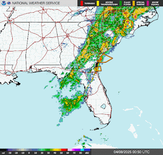
3:42 - And now Huntsville and surrounding areas join the onslaught of flash flood warnings.


3:46 - Got a possible tornado moving through Noxubee and Kemper Counties in Mississippi. It will probably weaken as it moves Northeast, but it's something to watch, since this long night is not quite over for some of the southernmost counties of North AL.
3:49 - Just for fun . . . there is currently rain, fog, and mist in Cullman, a thunderstorm in the vicinity. The temperature is 61 degrees (well technically 60.8, but I round to whole numbers). The dewpoint is also 61 degrees, making the relative humidity 100%. Winds are out of the East at 8 miles per hour. The pressure is 29.94 inches and falling slowly. Visiblity is down to 1.75 miles.
It's 63 degrees in Jasper and 61 in Haleyville. You can have severe weather with marginally unstable-enough air like this, but the risk is really low.
Now on the other hand, Birmingham has mostly cloudy skies, a temperature of 74 and a dewpoint of 66. They certainly could see some severe weather over the next few hours in Jefferson County and thereabouts.

3:53 - And the Tornado Watch has been cancelled for Cullman, Marshall, Jackson, and Dekalb Counties now.
Walker County is technically under a watch until 10 AM CDT. But I think they're done with the severe weather down there too. Not going to wait on that to be cancelled. I'm posting a forecast summary and sacking out. On the chance they did get something, they're covered by my NOAA Weather Radio, unlike a lot of these other counties.
Special Weather Statement
National Weather Service Huntsville AL
316 AM CDT Sun Apr 6 2025
ALZ016-060915-
Cullman AL-
316 AM CDT Sun Apr 6 2025
...A STRONG THUNDERSTORM WILL IMPACT CULLMAN COUNTY THROUGH 415 AM
CDT...
At 315 AM CDT, Doppler radar was tracking a strong thunderstorm near
Jasper, moving northeast at 35 mph.
HAZARD...Wind gusts up to 40 mph.
SOURCE...Radar indicated.
IMPACT...Gusty winds could knock down tree limbs and blow around
unsecured objects.
Locations impacted include...
Phelan, Walter, Wilburn, Good Hope, Cullman, Black Bottom, Baldwin,
Crane Hill, Garden City, and Smith Lake.
PRECAUTIONARY/PREPAREDNESS ACTIONS...
Torrential rainfall is also occurring with this storm and may lead to
localized flooding. Do not drive your vehicle through flooded
roadways.
Frequent cloud to ground lightning is occurring with this storm.
Lightning can strike 10 miles away from a thunderstorm. Seek a safe
shelter inside a building or vehicle.
A Tornado Watch remains in effect until 500 AM CDT for north central
Alabama.
&&
LAT...LON 3389 8701 3390 8710 3392 8708 3399 8715
3399 8711 3431 8711 3431 8683 3412 8660
3409 8668 3409 8669 3405 8668 3406 8671
3403 8670 3398 8676 3393 8686 3394 8688
3391 8692 3387 8692 3386 8696
TIME...MOT...LOC 0815Z 235DEG 38KT 3391 8734
MAX HAIL SIZE...0.00 IN
MAX WIND GUST...40 MPH
$$
26
Special Weather Statement
National Weather Service Peachtree City GA
401 AM EDT Sun Apr 6 2025
GAZ002-004-005-011-012-019-060830-
Chattooga GA-Whitfield GA-Walker GA-Gordon GA-Murray GA-Floyd GA-
401 AM EDT Sun Apr 6 2025
...Strong thunderstorms will impact portions of west central Murray,
central Floyd, southern Whitfield, southeastern Walker, northwestern
Gordon and Chattooga Counties through 430 AM EDT...
At 401 AM EDT, a line of strong thunderstorms was along a line
extending from near Mill Creek to Center Post to near Broomtown, and
moving east at 30 mph.
HAZARD...Up to 40 mph wind, frequent cloud to ground lightning and
heavy rain.
SOURCE...Radar indicated.
IMPACT...Expect minor damage to tree limbs and blowing around of
light, unsecured objects. Heavy rain may cause temporary
street flooding especially in poor drainage areas.
Locations impacted include...
Naomi, Center Post, Subligna, Suttles Mill, Tidings, Summerville,
Lake Marvin, Tilton, Lyerly, Mill Creek, Menlo, Villanow, Berryton,
Chattoogaville, Everett Springs, James H. Floyd State Park, Trion,
Holland, Dalton, and La Fayette.
PRECAUTIONARY/PREPAREDNESS ACTIONS...
People outdoors should seek shelter immediately. If you can hear
thunder, you are close enough to be struck by lightning. Motorists
should slow down and be prepared for possible loss of control due to
hydroplaning.
A Tornado Watch remains in effect until 1100 AM EDT for northwestern
Georgia.
&&
LAT...LON 3459 8542 3477 8516 3477 8515 3479 8513
3472 8484 3451 8510 3426 8532 3430 8547
3449 8551
TIME...MOT...LOC 0801Z 279DEG 26KT 3476 8511 3461 8534 3438 8556
MAX HAIL SIZE...0.00 IN
MAX WIND GUST...40 MPH
$$
Special Weather Statement
National Weather Service Birmingham AL
252 AM CDT Sun Apr 6 2025
ALZ014-015-060845-
Walker AL-Winston AL-
252 AM CDT Sun Apr 6 2025
...A STRONG THUNDERSTORM WILL IMPACT WALKER AND SOUTHEASTERN WINSTON
COUNTIES THROUGH 345 AM CDT...
At 252 AM CDT, Doppler radar was tracking a strong thunderstorm 8
miles south of Kansas, or 8 miles southwest of Carbon Hill, moving
northeast at 50 mph.
HAZARD...Wind gusts up to 40 mph and half inch hail.
SOURCE...Radar indicated.
IMPACT...Gusty winds could knock down tree limbs and blow around
unsecured objects. Minor hail damage to vegetation is
possible.
Locations impacted include...
Curry, Camp McDowell, Mill Branch, Smith Dam, Nesmith, Ashbank, Coon
Creek, Poplar Springs, Powellville, Corona, Battle Branch, Hidden
Cove Campground, Townley, Black Pond, Eldridge, Wilson Bend, Devils
Branch, Kansas, Seymour Branch, and Duncan Bridge.
PRECAUTIONARY/PREPAREDNESS ACTIONS...
If outdoors, consider seeking shelter inside a building.
A Tornado Watch remains in effect until 1000 AM CDT for central and
west central Alabama.
&&
LAT...LON 3421 8711 3399 8711 3399 8715 3396 8713
3396 8711 3394 8710 3391 8708 3390 8710
3389 8709 3389 8701 3387 8700 3386 8697
3360 8742 3369 8742 3369 8753 3387 8753
3387 8763 3393 8764
TIME...MOT...LOC 0752Z 236DEG 44KT 3379 8759
MAX HAIL SIZE...0.50 IN
MAX WIND GUST...40 MPH
$$
25/Owen


No comments:
Post a Comment