Sunday, April 20, 2025

Forecast Summary

Looks like a mix of sun and clouds for Easter Sunday, a breezy day with a High near 84. 

Another breezy day Monday with showers and thunderstorms likely, a High of about 80 or so, morning Low in the lower 60's. 

A cold front is moving in here and going to stall out. A high pressure ridge has kept it out of here for a while. 

Mostly cloudy with a 50% chance of showers on Tuesday with a High in the mid-70's, Low near 60. Could still have some thunder in there.

Chance of rain drops to 40% for Wednesday, High near 80, Low near 60, partly cloudy skies. 

Thursday through Saturday, chance of rain drops to 30%, so widely scattered showers (or thunderstorms) possible, partly to mostly sunny skies, Highs in the lower 80's and Lows in the lower 60's. 

Substack

Patreon

Buy Me a Coffee

For those who would like to see the more detailed forecasts/discussions more often, here are the links to support these weather blogging efforts. It takes a lot of time and energy to do right, a thorough job, and right now, I'm thinking of it as something to try about once a week, since the weather has calmed down quite a bit. We had several rounds of severe weather in the region earlier this season. We still have another week or so in this month and then the month of May to keep an eye on as far as our severe weather season. But trends right now are for more of an unsettled summerlike pattern that mainly brings us beneficial rain. 

Friday, April 18, 2025

Warm and Pleasant Easter Weekend, Somewhat Unsettled Week Ahead

FORECAST:

Friday (High 81, Low 54): Mostly sunny. Warm and breezy.

Saturday (High 83, Low 58): Partly to mostly sunny. Warm and breezy.

Easter Sunday (High 82, Low 60): Partly cloudy. Warm and breezy.

EXTENDED OUTLOOK:

Monday (High 80, Low 62): Mostly cloudy with a 50% chance of showers/thunderstorms.

Tuesday (High 78, Low 59): Partly cloudy with a 40% chance of showers/thunderstorms.

Wednesday (High 81, Low 57): Partly cloudy with a 20% chance of showers/thunderstorms.

Thursday (High 80, Low 59): Partly cloudy with a 30% chance of showers/thunderstorms.

PRONÓSTICO:

Viernes (Máxima: 81, Mínima: 54): Mayormente soleado. Cálido y ventilado.

Sábado (Máxima: 83, Mínima: 58): Parcialmente soleado. Cálido y ventilado.

Domingo de Pascua (Máxima: 82, Mínima: 60): Parcialmente nublado. Cálido y ventilado.

PERSPECTIVA EXTENDIDA:

Lunes (Máxima: 80, Mínima: 62): Mayormente nublado con un 50 % de probabilidad de lluvias/tormentas eléctricas.

Martes (Máxima: 78, Mínima: 59): Parcialmente nublado con un 40 % de probabilidad de lluvias/tormentas eléctricas.

Miércoles (Máxima: 81, Mínima: 57): Parcialmente nublado con un 20 % de probabilidad de lluvias/tormentas eléctricas.

Jueves (Máxima: 80, Mínima: 59): Parcialmente nublado con un 30 % de probabilidad de lluvias/tormentas eléctricas.

NOTES:

There is one more SKYWARN class this season, Tuesday April 22 5 PM at the AIDB Shoals Regional Center. This class is geared toward people who are deaf or hard-of-hearing.

We recently had the anniversary of the forgotten tornado outbreak of April 15, 2011, which mainly affected Central and South Alabama. It sort of got overshadowed by the even worse outbreak that hit more in North and Central Alabama on the 27th of that same month, not even two weeks later. But I remember this thing, and it was a stout tornado outbreak in its own right. I remember on the weather blog I had then, I was disappointed that it didn’t do anything in North Alabama, felt like I’d given my readers an overhyped forecast that just totally busted.

DISCUSSION:

Available on Substack.

P.S. It's 2:47 AM Friday now . . . and . . . 


I tried a YouTube video for the first time in years. Not even sure I'm using the best program for it, but one step at a time as I try to make this into a professional project one way or the other. 

Thursday, April 10, 2025

Milder, More Pleasant Weather on the Way - Maybe Lasting Into Easter Weekend

FORECAST:

Friday (High 63, Low 45): Partly to mostly sunny and breezy. Isolated showers may linger.

Saturday (High 62, Low 39): Sunny. Cool.

Sunday (High 72, Low 37): Sunny. Cool.

EXTENDED OUTLOOK:

Monday (High 80, Low 50): Mostly sunny.

Tuesday (High 69, Low 53): Partly to mostly sunny.

Wednesday (High 70, Low 42): Sunny.

Thursday (High 72, Low 47): Partly cloudy with a 20% chance of showers/thunderstorms.

READING TEA LEAVES:

Good Friday (High 75, Low 54): Partly cloudy with a 20% chance of showers/thunderstorms. 

Saturday (High 76, Low 51): Mostly sunny.

Easter Sunday (High 78, Low 52): Sunny.

PRONÓSTICO:

Viernes (Máxima 63, Mínima: 45): Parcialmente soleado y ventoso. Podrían persistir algunas lluvias aisladas.

Sábado (Máxima 62, Mínima: 39): Soleado. Fresco.

Domingo (Máxima: 72, Mínima: 37): Soleado. Fresco.

PERSPECTIVA EXTENDIDA:

Lunes (Máxima 80, Mínima: 50): Mayormente soleado.

Martes (Máxima: 69, Mínima: 53): Parcialmente soleado.

Miércoles (Máxima: 70, Mínima: 42): Soleado.

Jueves (Máxima: 72, Mínima: 47): Parcialmente nublado con un 20 % de probabilidad de lluvias/tormentas eléctricas.

LEYENDO LAS HOJAS DE TÉ:

Viernes Santo (Máxima: 75, Mínima: 54): Parcialmente nublado con un 20 % de probabilidad de lluvias/tormentas eléctricas.

Sábado (Máxima: 76, Mínima: 51): Mayormente soleado.

Domingo de Pascua (Máxima: 78, Mínima: 52): Soleado.

NOTES:

Next SKYWARN class is at the AIDB Decatur Regional Center, 3 PM Wednesday April 16th and is specifically geared toward the deaf and hard of hearing. Folks who have friends/loved ones with hearing problems might consider taking them to one of these classes. It does present a special challenge for communicating severe weather information. I know that Meghan Thomas who currently works for FOX-6 in Birmingham has advocated a lot for this community over the years, remember seeing stuff about it when she worked in Nashville. There is another such class in Tuscumbia on the 22nd. 

The National Weather Service in Nashville continues to do online Weather101 classes. Two classes are coming up Monday, one on global circulations in the morning, then one on flooding in the evening. 

DISCUSSION:

See Substack. You'll need to subscribe, although I did include a free version of just the audio discussion, since it came out kinda' rough. 

10:49 PM Update - Actually that "voiceover" is automatically behind the paywall. This is only my second day of writing on Substack, so I'm still figuring things out. 

Will record a short version of things for free that I can sandwich in there below the main bullet-points forecast. The audio file where I was describing the discussion ended up being lengthy, at least half an hour. And I meant to make it part of the free section, but apparently that is not an option. Just wanted to give people an idea of what extras they will get by subscribing. 

11:17 - Ok the free audio is between the forecast and notes section over on Substack. Blogger doesn't allow audio files to be put in here, only video. 

Things are definitely in a transition phase here . . . 

Severe T-Storm Warning (Walker County)

 Severe Thunderstorm Warning

ALC127-110200-

/O.NEW.KBMX.SV.W.0095.250411T0122Z-250411T0200Z/


BULLETIN - IMMEDIATE BROADCAST REQUESTED

Severe Thunderstorm Warning

National Weather Service Birmingham AL

822 PM CDT Thu Apr 10 2025


The National Weather Service in Birmingham has issued a


* Severe Thunderstorm Warning for...

  Central Walker County in central Alabama...


* Until 900 PM CDT.


* At 822 PM CDT, a severe thunderstorm was located over Oakman, or 9

  miles southwest of Jasper, moving southeast at 40 mph.


  HAZARD...60 mph wind gusts.


  SOURCE...Radar indicated.


  IMPACT...Expect damage to roofs, siding, and trees.


* Locations impacted include...

  Goodsprings, Barney, Gorgas Steam Plant, Rocky Hollow, Sumiton,

  Burnwell, West Corona, Beloit, Quinton, Cedrum Area, Holly Grove,

  Gorgas, The Wye, Tutwiler, Parrish, Oakman, Dora, Corona, Townley,

  and Cordova.


PRECAUTIONARY/PREPAREDNESS ACTIONS...


For your protection move to an interior room on the lowest floor of a

building.


&&


LAT...LON 3382 8719 3376 8702 3366 8706 3366 8709

      3363 8710 3363 8714 3361 8715 3360 8719

      3357 8720 3355 8719 3354 8723 3352 8725

      3354 8732 3359 8732 3360 8742 3369 8743

      3369 8753 3387 8753 3387 8755 3390 8755

TIME...MOT...LOC 0122Z 302DEG 33KT 3375 8738


HAIL THREAT...RADAR INDICATED

MAX HAIL SIZE...<.75 IN

WIND THREAT...RADAR INDICATED

MAX WIND GUST...60 MPH


$$


86/Martin


Special Weather Statement(s)


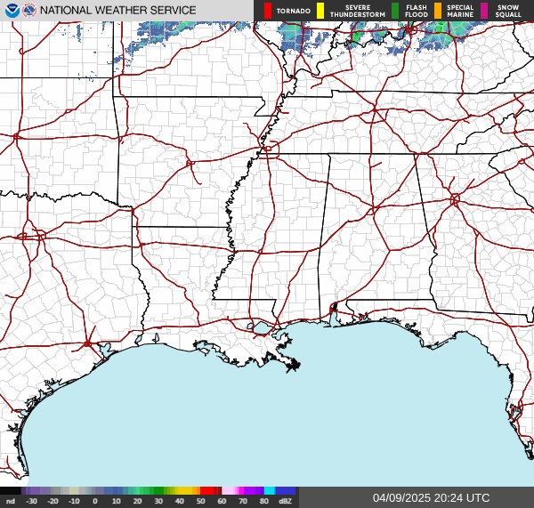
The storms in North Alabama are being covered by special weather statements now instead of severe thunderstorm warnings. So the storms are kind of strong but not such a direct threat to life and property as earlier, when producing large hail and blowing trees and power lines down. 

By that way, that yellow in Southeast Cullman County is a warning that is no longer valid. It just hasn't gone off the map yet, something I have no control over. But the warning is actually gone there. 

7:45 - All TN counties are out of the watch now, the ones that border AL. Alabama counties that were under the watch still are until 11 PM CDT unless it is cancelled earlier. I think it will be, but that's not my call to make. 

7:48 - And the polygons have been updated, so here's the broad radar view. 

Going to work on a forecast. 

Special Weather Statement

National Weather Service Huntsville AL

736 PM CDT Thu Apr 10 2025


ALZ006-008>010-TNZ076-096-097-110115-

Marshall AL-Madison AL-DeKalb AL-Jackson AL-Franklin TN-Moore TN-

Lincoln TN-

736 PM CDT Thu Apr 10 2025


...STRONG THUNDERSTORMS WILL IMPACT SOUTHEASTERN MARSHALL...

JACKSON...NORTHEASTERN MADISON...DEKALB...SOUTHEASTERN MOORE...

SOUTHEASTERN LINCOLN AND FRANKLIN COUNTIES THROUGH 815 PM CDT...


At 736 PM CDT, Doppler radar was tracking strong thunderstorms along

a line extending from 7 miles west of Skyline to near Section to

Albertville. Movement was southeast at 55 mph.


HAZARD...Wind gusts up to 30 to 50 mph.


SOURCE...Radar indicated.


IMPACT...Gusty winds could knock down tree limbs and blow around

         unsecured objects.


Locations impacted include...

High Point, Lim Rock, Hurdlow, Maxwell, Ider, St. Andrews, Larkin,

Bridgeport, Pine Ridge, and Smithland.


PRECAUTIONARY/PREPAREDNESS ACTIONS...


If outdoors, consider seeking shelter inside a building.


A Severe Thunderstorm Watch remains in effect until 1100 PM CDT for

north central and northeastern Alabama...and Middle Tennessee.


&&


LAT...LON 3448 8558 3444 8558 3437 8563 3436 8566

      3426 8577 3424 8584 3420 8585 3420 8611

      3419 8611 3418 8619 3414 8624 3418 8638

      3429 8648 3452 8612 3513 8656 3530 8594

      3522 8586 3499 8586 3498 8561 3453 8551

TIME...MOT...LOC 0036Z 293DEG 48KT 3478 8624 3450 8603 3426 8619


MAX HAIL SIZE...0.00 IN

MAX WIND GUST...50 MPH


$$


KTW

Special Weather Statement

National Weather Service Huntsville AL

703 PM CDT Thu Apr 10 2025


ALZ007-008-016-110045-

Marshall AL-Morgan AL-Cullman AL-

703 PM CDT Thu Apr 10 2025


...STRONG THUNDERSTORMS WILL IMPACT WEST CENTRAL MARSHALL...CULLMAN

AND SOUTHEASTERN MORGAN COUNTIES THROUGH 745 PM CDT...


At 703 PM CDT, Doppler radar was tracking strong thunderstorms along

a line extending from Strawberry to near Dodge City to Corinth Rec

Area. Movement was south at 55 mph.


HAZARD...Wind gusts of 50 to 55 mph and nickel size hail.


SOURCE...Radar indicated.


IMPACT...Gusty winds could knock down tree limbs and blow around

         unsecured objects. Minor hail damage to vegetation is

         possible.


Locations impacted include...

Phelan, Wilburn, Good Hope, Cullman, Black Bottom, Crane Hill, Smith

Lake, Hulaco, Holly Pond, and Bremen.


PRECAUTIONARY/PREPAREDNESS ACTIONS...


If outdoors, consider seeking shelter inside a building.


A Severe Thunderstorm Watch remains in effect until 1100 PM CDT for

north central and northeastern Alabama.


&&


LAT...LON 3390 8710 3392 8708 3399 8715 3399 8711

      3427 8711 3427 8695 3437 8651 3426 8646

      3425 8652 3412 8660 3408 8670 3405 8668

      3406 8671 3403 8670 3395 8679 3394 8688

      3391 8692 3387 8692 3386 8696

TIME...MOT...LOC 0003Z 341DEG 47KT 3425 8650 3403 8684 3413 8731


MAX HAIL SIZE...0.88 IN

MAX WIND GUST...55 MPH


$$


HC

Special Weather Statement

National Weather Service Birmingham AL

736 PM CDT Thu Apr 10 2025


ALZ011-110100-

Marion AL-

736 PM CDT Thu Apr 10 2025


...STRONG THUNDERSTORMS WILL IMPACT NORTHERN MARION COUNTY THROUGH

800 PM CDT...


At 736 PM CDT, Doppler radar was tracking a cluster of strong

thunderstorms near Weston, or near Hamilton, moving east at 50 mph.


HAZARD...Wind gusts up to 40 mph.


SOURCE...Radar indicated.


IMPACT...Gusty winds could knock down tree limbs and blow around

         unsecured objects.


Locations impacted include...

Tessner, Shottsville, Pearces Mill, Rankin Fite Airport, Brinn,

Hackleburg, Upper Bear Creek Reservoir, Weston, Lake Buttahatchee,

Bear Creek, Hamilton, Bexar, Pigeye, and Haleyville.


PRECAUTIONARY/PREPAREDNESS ACTIONS...


If outdoors, consider seeking shelter inside a building.


A Severe Thunderstorm Watch remains in effect until 1100 PM CDT for

northwestern Alabama.


&&


LAT...LON 3430 8763 3424 8763 3410 8764 3412 8817

      3432 8815

TIME...MOT...LOC 0036Z 272DEG 42KT 3424 8798


MAX HAIL SIZE...0.00 IN

MAX WIND GUST...40 MPH


$$


89^GSatterwhite

Special Weather Statement

National Weather Service Birmingham AL

725 PM CDT Thu Apr 10 2025


ALZ011>013-110130-

Fayette AL-Marion AL-Lamar AL-

725 PM CDT Thu Apr 10 2025


...STRONG THUNDERSTORMS WILL IMPACT SOUTHEASTERN MARION...FAYETTE AND

LAMAR COUNTIES THROUGH 830 PM CDT...


At 725 PM CDT, Doppler radar was tracking a cluster of strong

thunderstorms near Detroit, or 8 miles northwest of Sulligent, moving

southeast at 35 mph.


HAZARD...Wind gusts near 40 mph.


SOURCE...Radar indicated.


IMPACT...Gusty winds could knock down tree limbs and blow around

         unsecured objects.


Locations impacted include...

Tucker, Cody, Stone Wall, Detroit, Henson Springs, Bankston, Wayside,

Richard Arthur Field, Winfield, Fayette County Public Lake, Fayette,

Kennedy, Brilliant, Guin, Gu-

Win, Star, Pine Springs, Hightogy, Glen Allen, and Crossville.


PRECAUTIONARY/PREPAREDNESS ACTIONS...


If outdoors, consider seeking shelter inside a building.


A Severe Thunderstorm Watch remains in effect until 1100 PM CDT for

central, northwestern and west central Alabama.


&&


LAT...LON 3405 8820 3402 8763 3358 8763 3358 8767

      3352 8767 3354 8828

TIME...MOT...LOC 0025Z 294DEG 31KT 3398 8822


MAX HAIL SIZE...0.00 IN

MAX WIND GUST...40 MPH


$$


89^GSatterwhite

Special Weather Statement

National Weather Service Peachtree City GA

808 PM EDT Thu Apr 10 2025


GAZ002-004-005-011-012-019-110045-

Chattooga GA-Whitfield GA-Walker GA-Gordon GA-Murray GA-Floyd GA-

808 PM EDT Thu Apr 10 2025


...A strong thunderstorm will impact portions of southwestern Murray,

northeastern Floyd, south central Whitfield, southeastern Walker,

Gordon and northeastern Chattooga Counties through 845 PM EDT...


At 808 PM EDT, a strong thunderstorm was over Lake Marvin, or 9 miles

northwest of Calhoun, moving southeast at 30 mph.


HAZARD...40 to 50 mph wind, nickel sized hail and frequent cloud to

         ground lightning.


SOURCE...Radar indicated.


IMPACT...Expect minor damage to tree limbs and blowing around of

         light, unsecured objects.


Locations impacted include...

Sonoraville, Calhoun, Oostanaula, Sugar Valley, Redbud, Lake Marvin,

Resaca, Nickelsville, Audubon, and Villanow.


PRECAUTIONARY/PREPAREDNESS ACTIONS...


People outdoors should seek shelter immediately. If you can hear

thunder, you are close enough to be struck by lightning.


A Severe Thunderstorm Watch remains in effect until midnight EDT for

northwestern Georgia.


&&


LAT...LON 3457 8519 3468 8511 3462 8479 3447 8474

      3440 8494

TIME...MOT...LOC 0008Z 296DEG 24KT 3459 8506


MAX HAIL SIZE...0.88 IN

MAX WIND GUST...50 MPH


$$

Special Weather Statement

National Weather Service Nashville TN

708 PM CDT Thu Apr 10 2025


TNZ065-080-110045-

Van Buren TN-White TN-

708 PM CDT Thu Apr 10 2025


...A STRONG THUNDERSTORM WILL IMPACT NORTHERN VAN BUREN AND

SOUTHEASTERN WHITE COUNTIES THROUGH 745 PM CDT...


At 707 PM CDT, the public reported a strong thunderstorm near

Spencer, moving east at 15 mph.


HAZARD...Wind gusts up to 40 mph and penny size hail.


SOURCE...Public.


IMPACT...Gusty winds could knock down tree limbs and blow around

         unsecured objects. Minor hail damage to vegetation is

         possible.


Locations impacted include...

Virgin Falls State Natural Area, Spencer, Fall Creek Falls State

Park, Doyle, and Sparta.


PRECAUTIONARY/PREPAREDNESS ACTIONS...


If outdoors, consider seeking shelter inside a building.


&&


LAT...LON 3580 8525 3580 8526 3579 8527 3578 8526

      3576 8525 3576 8527 3575 8526 3573 8527

      3572 8527 3566 8532 3577 8558 3593 8551

      3586 8523

TIME...MOT...LOC 0007Z 289DEG 15KT 3582 8547


MAX HAIL SIZE...0.75 IN

MAX WIND GUST...40 MPH


$$


10


Severe T-Storm Warning (Cullman Again)

Basically the whole county this time. 

You don't necessarily have to take tornado-level precautions for these storms, but at least I'd stay inside, away from windows and electrical stuff. And if you've got trees around, it's better if you can be on the lower floor of a sturdy house instead of a mobile home, or say, up on the top floor of an apartment. And any smaller room like a hallway or a laundry room without windows is better, because we have had some trees fall on homes this evening. 

7:18 PM - This new warning is mainly for Blount County, once again included nearly the whole county. It also affects much of Northern Jefferson County, the Eastern sliver of Walker County, and extends over into St. Clair County in Central Alabama. 

Weather radio is reporting widespread trees down across Cullman County. 

7:21 - Amateur radio reports at Blountsville, a tree fell on a home off of Joy Road. 

So if you're in the path of these storms, the best place to be is a small interior room (no windows) on the lowest floor of a sturdy house. Mobile homes are less safe in general, plus trees often come all the way through them. In a site-built house, a lot of times those tighter walls like in a hallway or laundry room or closet or bathroom will keep a tree from coming all the way through. 

7:25 - As the guy from WAFF-48 (don't recognize his voice yet) notes, this turned into a busy evening. Numerous reports of tree and power line damage. And in some cases, the trees fell on homes. Before that, it was more of a large hail threat. I remember around Sardis City and Boaz, they had golfball-sized hail. 

7:29 - If there is a silver lining, these storms are moving along at a pretty good clip. So they won't hover over any one area for very long. That fast motion can enhance the winds though. 

7:31 - The storms in Cullman County are now down around Inland Lake, Springville, Hanceville, Arkadelphia, Black Bottom, Colony, Garden City, and Dodge City. Places like Holly Pond and Baileyton could also still be affected. 

7:33 - Hmmmmm, but it's actually just about out of Cullman County. I was just passing along the latest NWS Huntsville update above. 

7:35 - And emergency manager reports large trees down around Blountsville and Fowler Springs. 

Also across Oneonta. 

This event lived up to its potential more than I expected, I'll go ahead and admit. 

7:37 - Huntsville Utilities reporting nearly 12,000 customers without power. 

 Severe Thunderstorm Warning

ALC043-110045-

/O.NEW.KHUN.SV.W.0079.250411T0011Z-250411T0045Z/


BULLETIN - IMMEDIATE BROADCAST REQUESTED

Severe Thunderstorm Warning

National Weather Service Huntsville AL

711 PM CDT Thu Apr 10 2025


The National Weather Service in Huntsville Alabama has issued a


* Severe Thunderstorm Warning for...

  Cullman County in north central Alabama...


* Until 745 PM CDT.


* At 710 PM CDT, a severe thunderstorm was located over Hanceville,

  or near Cullman, moving southeast at 60 mph.


  HAZARD...60 mph wind gusts.


  SOURCE...Radar indicated.


  IMPACT...Expect damage to roofs, siding, and trees.


* Locations impacted include...

  Phelan, Walter, Wilburn, Good Hope, Baileyton, Cullman, Black

  Bottom, Baldwin, Crane Hill, and Garden City.


PRECAUTIONARY/PREPAREDNESS ACTIONS...


For your protection move to an interior room on the lowest floor of a

building.


&&


LAT...LON 3390 8710 3392 8708 3399 8715 3399 8711

      3421 8711 3431 8670 3431 8659 3423 8653

      3419 8655 3418 8655 3412 8660 3408 8670

      3405 8668 3406 8671 3403 8670 3395 8679

      3394 8688 3391 8692 3387 8692 3386 8696

TIME...MOT...LOC 0010Z 317DEG 53KT 3408 8680


HAIL THREAT...RADAR INDICATED

MAX HAIL SIZE...<.75 IN

WIND THREAT...RADAR INDICATED

MAX WIND GUST...60 MPH


$$


HC


Severe T'Storm Warning

Please don't get caught out in this. Like if you're driving and maybe one of your passengers catches this warning on here, pull over somewhere. And it'd be better to get into a building than sit in the car when you've got hail that could be to the size of ping pong balls. These storms this evening have brought down some trees and power lines at times too. 

6:47 - Worth mentioning that we've also got a thunderstorm in Winston County affecting places like Double Springs, Addison, to Arley. 

These wind gusts are estimated up to 50 mph, which is just under severe limits. Has to be 58 mph or greater to be severe. 

6:55 PM - As storms continue to track Southeast, the outflow has produced more wind damage. Trees were reported down at Hazel Tree by broadcast media, and a new warning has been issued for Eastern Madison, Jackson, Dekalb Counties in Alabama and also Lincoln and Franklin Counties in Tennessee. Can see the new warning polygon above. Though I wouldn't blame you for getting a little confused at all the polygons overlapping. So if in doubt, go ahead and be in a safe enough place. This new warning goes until 8 PM CDT. 

It took three tries to get that last radar image to go through. Let's zoom in a bit on Cullman County and nearby. 

7:03 PM - And you can see the threat now is past the city of Cullman as far as the severe part of the thunderstorms. It's affecting places like Holly Pond up to Baileyton up through Arab and into Marshall County, also places like Snead in Northern Blount County. 

These warnings are for large hail and damaging winds. We've had hail anywhere from quarter to golfball sized this evening in these storms and several instances of the wind bringing down trees and power lines, falling on houses in a few cases. 

7:07 - And actually the warning for Cullman and Marshall Counties has been cancelled now as the storm has weakened. Another warning clips Northern Marshall County, places like Grant. And of course we have the warning for Northern Blount County that includes Snead. And the warning all the way from Moores Mill to Scottsboro there up at the state line. 

7:09 - Lawrence and Giles Counties have been cleared from the watch. 

7:10 - Decatur Utilities is responding to an outage affecting 969 customers up that way. 

New warning coming in locally. Cullman County has new warning. Will make new post for it. 

 Severe Thunderstorm Warning

ALC043-095-103-110030-

/O.NEW.KHUN.SV.W.0076.250410T2341Z-250411T0030Z/


BULLETIN - IMMEDIATE BROADCAST REQUESTED

Severe Thunderstorm Warning

National Weather Service Huntsville AL

641 PM CDT Thu Apr 10 2025


The National Weather Service in Huntsville Alabama has issued a


* Severe Thunderstorm Warning for...

  Southwestern Marshall County in northeastern Alabama...

  Northeastern Cullman County in north central Alabama...

  Southeastern Morgan County in north central Alabama...


* Until 730 PM CDT.


* At 640 PM CDT, a severe thunderstorm was located near Holly Pond,

  or 8 miles east of Cullman, moving east at 45 mph.


  HAZARD...Ping pong ball size hail and 60 mph wind gusts.


  SOURCE...Radar indicated.


  IMPACT...People and animals outdoors will be injured. Expect hail

           damage to roofs, siding, windows, and vehicles. Expect

           wind damage to roofs, siding, and trees.


* Locations impacted include...

  Phelan, Walter, High Point, Baileyton, Horton, Arab, Hulaco,

  Douglas, Holly Pond, and Eddy.


PRECAUTIONARY/PREPAREDNESS ACTIONS...


For your protection move to an interior room on the lowest floor of a

building.


&&


LAT...LON 3413 8683 3441 8671 3436 8641 3430 8622

      3410 8630 3420 8640 3426 8644 3426 8647

      3425 8652 3420 8655 3419 8655 3412 8660

      3412 8663 3409 8666 3408 8670 3405 8668

      3406 8670 3404 8670

TIME...MOT...LOC 2340Z 290DEG 37KT 3418 8670


HAIL THREAT...RADAR INDICATED

MAX HAIL SIZE...1.50 IN

WIND THREAT...RADAR INDICATED

MAX WIND GUST...60 MPH


$$


HC

Severe Thunderstorm Warning


6:22 PM - Remember that we have other warnings in effect with this system this evening too.


And that's Northern Jackson County, Marshall County, Western Dekalb County, and Northern Etowah County. 

Cherokee County was just added while I was typing this. That storm that has affected Marshall and Etowah, moving into Cherokee County, has a history of producing hail 2 inches in diameter. 

Further North, we have warnings affecting Shelbyville through Murfreesboro to McMinnville in Tennessee. 

6:27 - And for this new warning, storm coming out of Albertville, 70 mph wind gusts and hail up to ping pong ball size are possible. 

6:30 - And a new warning was just issued for a storm coming from Redstone Arsenal, capable of 60 mph wind gusts and quarter sized hail. 

6:32 - Then let's zoom in again, we've got a storm coming from Holly Pond toward Blountsville and Snead, polygon also clips places like Oneonta in Blount County. 

6:34 - Looks like a tree came down on a house at Town Creek earlier in Lawrence County, AL earlier, but no injuries. 

This event is a reminder not to downplay even the low-end severe weather potentials. If a tree falls on somebody's house and they're not ready for it, like if they're in an open living room where a tree comes in and breaks a lot of glass to boot, you can have serious injuries sometimes. Note to self, my great-grandmother was right in taking severe thunderstorms seriously even when they were not trying to produce tornadoes. Sometimes we all need a reminder I guess. 

And here's a good example of the hail that fell in Albertville. Now that storm is moving through Cherokee County in East Central Alabama.  

6:38 - This warning for Southeast Lawrence, Southern Morgan, and Northern Cullman Counties goes for about another 20 minutes. 

6:41 - The warning for Northern Jackson County is being allowed to expire in a few minutes, because that storm has weakened below severe limits. 

They've reissued Cullman warning, but it only includes far Northeast parts of the county, so not making a new post. Just going to . . . well yeah I'll make a new post. So you get all the technical details. 

476 

WUUS54 KHUN 102318

SVRHUN

ALC043-079-103-110000-

/O.NEW.KHUN.SV.W.0073.250410T2318Z-250411T0000Z/


BULLETIN - IMMEDIATE BROADCAST REQUESTED

Severe Thunderstorm Warning

National Weather Service Huntsville AL

618 PM CDT Thu Apr 10 2025


The National Weather Service in Huntsville Alabama has issued a


* Severe Thunderstorm Warning for...

  Northwestern Cullman County in north central Alabama...

  Southern Morgan County in north central Alabama...

  Southeastern Lawrence County in northwestern Alabama...


* Until 700 PM CDT.


* At 618 PM CDT, a severe thunderstorm was located 7 miles southeast

  of Moulton, moving southeast at 40 mph.


  HAZARD...60 mph wind gusts and quarter size hail.


  SOURCE...Radar indicated.


  IMPACT...Hail damage to vehicles is expected. Expect wind damage 

           to roofs, siding, and trees.


* Locations impacted include...

  Phelan, Walter, Good Hope, Cullman, Baldwin, Falkville, Speake,

  Cole Springs, Battleground, and Eva.


PRECAUTIONARY/PREPAREDNESS ACTIONS...


For your protection move to an interior room on the lowest floor of a

building.


&&


LAT...LON 3417 8704 3423 8711 3430 8711 3430 8719

      3439 8730 3454 8720 3438 8659 3409 8665

      3408 8670 3405 8668 3406 8671 3403 8670

      3403 8672 3401 8673 3401 8674

TIME...MOT...LOC 2318Z 296DEG 36KT 3441 8718 


HAIL THREAT...RADAR INDICATED

MAX HAIL SIZE...1.00 IN

WIND THREAT...RADAR INDICATED

MAX WIND GUST...60 MPH


$$


HC

Severe Thunderstorm Warning

Going to start tracking these more closely, we had a tree down on a house in Loretto, TN within that severe thunderstorm warning polygon up there. And multiple reports of trees and power lines down in that general area. 

5:49 - So we've got Lawrence, Maury, and Marshall Counties still under a severe thunderstorm warning in Tennessee. Damage has been confirmed with trees and power lines coming down in these winds, one tree falling on a home - which can be a life-threatening situation. 

On the Alabama side we've got Morgan and Limestone Counties. Also Marshall, Morgan, and Southern Madison Counties clipped by a warning for another storm. And then Jackson and Dekalb Counties under a warning for a storm near Scottsboro. 

Of course you stay inside and away from windows/electrical stuff for these storms. 

It's better if you can be in a sturdy, site-built house instead of a mobile home, especially if you have trees around. And if you've got more than one floor, like if you're in an apartment, it's better if you can be down on the ground floor. You don't have to shelter as much as you would from a tornado, but stay away from windows, and see if you can get into a smaller space like a hallway or smaller room where the walls would be less likely to collapse if something like a tree were to fall onto the structure. 

This is a borderline setup for severe weather, but we have seen some damage. So we have to take it somewhat seriously. 

5:54 - And we've already got a new warning for the Northern part of Jackson County now, between Skyline and Winchester (TN), will affect places around Hytop.


5:58 - Just a note that the storm headed down toward Sardis City is estimated to have golfball sized hail. Wouldn't want to get hit in the head with that . . . 


And people are sharing pictures and videos that verify what the Weather Service is seeing on radar.  

6:04 PM - Several of our warnings have been let go, including the one that this post was initially made for. 

We still have warnings for Marshall, Dekalb, Jackson, and Etowah Counties. People in those polygons should stay in a safe place until the storms pass. Even if it's more of a hail threat, obviously you don't want to be out in it, even trying to drive. 

6:08 - Ping pong ball sized hail has been observed in the storm East of Boaz. 

Well that's what Huntsville says. The National Weather Service in Birmingham says the same area has observed golfball-sized hail. Anyway it's very large hail. 

6:12 - And it looks like NWS Huntsville may have just upgraded the Marshall/Dekalb County warning to say that golfball-sized hail was observed. 

6:13 - Yes, that storm between Boaz and Geraldine is marked as having confirmed two-inch-diameter hail. 

6:17 - Wayne County, TN has been cleared from the watch. Got another report of a tree down on road and power lines in Nashville. These storms have a history of damage, more on the Tennessee side. 

Severe Thunderstorm Warning

ALC079-103-102315-

/O.NEW.KHUN.SV.W.0069.250410T2245Z-250410T2315Z/


BULLETIN - IMMEDIATE BROADCAST REQUESTED

Severe Thunderstorm Warning

National Weather Service Huntsville AL

545 PM CDT Thu Apr 10 2025


The National Weather Service in Huntsville Alabama has issued a


* Severe Thunderstorm Warning for...

  Western Morgan County in north central Alabama...

  East central Lawrence County in northwestern Alabama...


* Until 615 PM CDT.


* At 544 PM CDT, a severe thunderstorm was located near Moulton,

  moving east at 35 mph.


  HAZARD...60 mph wind gusts and half dollar size hail.


  SOURCE...Radar indicated.


  IMPACT...Hail damage to vehicles is expected. Expect wind damage

           to roofs, siding, and trees.


* Locations impacted include...

  Decatur, Priceville, Trinity, Hartselle, Chalybeate Springs,

  Moulton, Falkville, Speake, Neel, and Caddo.


PRECAUTIONARY/PREPAREDNESS ACTIONS...


For your protection move to an interior room on the lowest floor of a

building.


&&


LAT...LON 3447 8742 3463 8740 3462 8698 3459 8693

      3457 8688 3435 8691

TIME...MOT...LOC 2244Z 278DEG 29KT 3456 8732


HAIL THREAT...RADAR INDICATED

MAX HAIL SIZE...1.25 IN

WIND THREAT...RADAR INDICATED

MAX WIND GUST...60 MPH


$$


KTW

Severe Weather Statement

These storms are mostly hailers today, once in a while one in Tennessee has done some tree damage. 

5:34 PM - Saw a report of trees down along Old Hickory Boulevard near Nashville. 

 Severe Weather Statement

National Weather Service Huntsville AL

519 PM CDT Thu Apr 10 2025


ALC049-071-089-095-102300-

/O.CON.KHUN.SV.W.0067.000000T0000Z-250410T2300Z/

Marshall AL-Jackson AL-Madison AL-DeKalb AL-

519 PM CDT Thu Apr 10 2025


...A SEVERE THUNDERSTORM WARNING REMAINS IN EFFECT UNTIL 600 PM CDT

FOR NORTHEASTERN MARSHALL...SOUTHWESTERN JACKSON...SOUTHEASTERN

MADISON AND WEST CENTRAL DEKALB COUNTIES...


At 518 PM CDT, a severe thunderstorm was located near Owens Cross

Roads, or 14 miles southeast of Huntsville, moving east at 40 mph.


HAZARD...60 mph wind gusts and quarter size hail.


SOURCE...Public. At 5:10 PM, quarter-sized hail was reported

         in southern Madison County.


IMPACT...Hail damage to vehicles is expected. Expect wind damage to

         roofs, siding, and trees.


Locations impacted include...

Paint Rock, Grant, Langston, Martintown, Lim Rock, Woodville,

Section, Scottsboro, Hollywood, and Larkinsville.


PRECAUTIONARY/PREPAREDNESS ACTIONS...


For your protection move to an interior room on the lowest floor of a

building.


&&


LAT...LON 3441 8592 3451 8649 3455 8654 3458 8655

      3465 8649 3479 8592

TIME...MOT...LOC 2218Z 271DEG 36KT 3461 8638


HAIL THREAT...OBSERVED

MAX HAIL SIZE...1.00 IN

WIND THREAT...RADAR INDICATED

MAX WIND GUST...60 MPH


$$


HC

Public Information Statement (Winfield Weather Radio Transmitter Degraded)

The best I can tell, the only alternate channel for Winston County is the Cullman transmitter. For Walker County, I believe the Birmingham, Oneonta transmitters are your alternate choices. I believe Marion County is covered by the transmitter out of Florence

Looks like the Tupelo transmitter covers Lamar County, AL as well as many East MS counties. 

 210 

NOUS44 KBMX 102058

PNSBMX

ALZ011>015-017>050-110900-


Public Information Statement

National Weather Service Birmingham AL

358 PM CDT Thu Apr 10 2025


...WINFIELD NOAA WEATHER RADIO IS DEGRADED...


The Winfield NOAA Weather Radio transmitter, broadcasting on a

frequency of 162.525 MHz, is currently degraded.


We are working with technicians to get it back up and running as

soon as possible. In the meantime, please refer to local media and

commercial radio for the latest severe weather information. Backup

NOAA Weather Radio transmitters are:


Tuscaloosa, broadcasting on a frequency of 162.400 MHz,

Aberdeen, MS, broadcasting on a frequency of 162.450 MHz, and

Birmingham, broadcasting on a frequency of 162.550 MHz.


Keep in mind that not all backup transmitters will tone for your

specific county, so please stay weather aware during the outage.


Thank you for your patience. We apologize for any inconvenience this

outage may cause.


$$

Severe Thunderstorm Watch


Guess I'll just post stuff here this evening since the Substack migration only started yesterday. This doesn't look like a big event, and I was surprised to hear some schools let out early for it. Maybe they were thinking about the hail threat and buses. 

 SEL6


   URGENT - IMMEDIATE BROADCAST REQUESTED

   Severe Thunderstorm Watch Number 136

   NWS Storm Prediction Center Norman OK

   335 PM CDT Thu Apr 10 2025


   The NWS Storm Prediction Center has issued a


   * Severe Thunderstorm Watch for portions of 

     Northern and Central Alabama

     Far Eastern Arkansas

     Northern and Central Mississippi

     Far Southern Middle Tennessee


   * Effective this Thursday afternoon and evening from 335 PM until

     1100 PM CDT.


   * Primary threats include...

     Scattered damaging winds likely with isolated significant gusts

       to 75 mph possible

     Scattered large hail likely with isolated very large hail events

       to 2 inches in diameter possible


   SUMMARY...Robust thunderstorms will continue to develop this

   afternoon and spread southeastward through the evening. Supercells

   will pose a threat for large hail generally ranging from 1-2 inches

   in diameter. Scattered severe/damaging winds, with peak gusts up to

   65-75 mph, should also occur as clusters form later this afternoon

   and evening.


   The severe thunderstorm watch area is approximately along and 70

   statute miles north and south of a line from 55 miles north

   northwest of Greenwood MS to 25 miles northeast of Anniston AL. For

   a complete depiction of the watch see the associated watch outline

   update (WOUS64 KWNS WOU6).


   PRECAUTIONARY/PREPAREDNESS ACTIONS...


   REMEMBER...A Severe Thunderstorm Watch means conditions are

   favorable for severe thunderstorms in and close to the watch area.

   Persons in these areas should be on the lookout for threatening

   weather conditions and listen for later statements and possible

   warnings. Severe thunderstorms can and occasionally do produce

   tornadoes.


   &&


   OTHER WATCH INFORMATION...CONTINUE...WW 135...


   AVIATION...A few severe thunderstorms with hail surface and aloft to

   2 inches. Extreme turbulence and surface wind gusts to 65 knots. A

   few cumulonimbi with maximum tops to 500. Mean storm motion vector

   31035.


   ...Gleason


 WOUS64 KWNS 102034

   WOU6


   BULLETIN - IMMEDIATE BROADCAST REQUESTED

   SEVERE THUNDERSTORM WATCH OUTLINE UPDATE FOR WS 136

   NWS STORM PREDICTION CENTER NORMAN OK

   335 PM CDT THU APR 10 2025


   SEVERE THUNDERSTORM WATCH 136 IS IN EFFECT UNTIL 1100 PM CDT

   FOR THE FOLLOWING LOCATIONS


   ALC007-009-015-017-019-021-027-029-033-037-043-049-055-057-059-

   063-065-071-073-075-077-079-083-089-093-095-103-105-107-111-115-

   117-119-121-123-125-127-133-110400-

   /O.NEW.KWNS.SV.A.0136.250410T2035Z-250411T0400Z/


   AL 

   .    ALABAMA COUNTIES INCLUDED ARE


   BIBB                 BLOUNT              CALHOUN             

   CHAMBERS             CHEROKEE            CHILTON             

   CLAY                 CLEBURNE            COLBERT             

   COOSA                CULLMAN             DEKALB              

   ETOWAH               FAYETTE             FRANKLIN            

   GREENE               HALE                JACKSON             

   JEFFERSON            LAMAR               LAUDERDALE          

   LAWRENCE             LIMESTONE           MADISON             

   MARION               MARSHALL            MORGAN              

   PERRY                PICKENS             RANDOLPH            

   SHELBY               ST. CLAIR           SUMTER              

   TALLADEGA            TALLAPOOSA          TUSCALOOSA          

   WALKER               WINSTON             


   ARC035-037-077-107-111-123-110400-

   /O.NEW.KWNS.SV.A.0136.250410T2035Z-250411T0400Z/


   AR 

   .    ARKANSAS COUNTIES INCLUDED ARE


   CRITTENDEN           CROSS               LEE                 

   PHILLIPS             POINSETT            ST. FRANCIS         


   MSC003-007-009-011-013-015-017-019-025-027-033-043-051-057-069-

   071-081-083-087-093-095-097-099-103-105-107-115-117-119-133-135-

   137-139-141-143-145-155-159-161-110400-

   /O.NEW.KWNS.SV.A.0136.250410T2035Z-250411T0400Z/


   MS 

   .    MISSISSIPPI COUNTIES INCLUDED ARE


   ALCORN               ATTALA              BENTON              

   BOLIVAR              CALHOUN             CARROLL             

   CHICKASAW            CHOCTAW             CLAY                

   COAHOMA              DESOTO              GRENADA             

   HOLMES               ITAWAMBA            KEMPER              

   LAFAYETTE            LEE                 LEFLORE             

   LOWNDES              MARSHALL            MONROE              

   MONTGOMERY           NESHOBA             NOXUBEE             

   OKTIBBEHA            PANOLA              PONTOTOC            

   PRENTISS             QUITMAN             SUNFLOWER           

   TALLAHATCHIE         TATE                TIPPAH              

   TISHOMINGO           TUNICA              UNION               

   WEBSTER              WINSTON             YALOBUSHA           


   TNC051-103-127-157-110400-

   /O.NEW.KWNS.SV.A.0136.250410T2035Z-250411T0400Z/


   TN 

   .    TENNESSEE COUNTIES INCLUDED ARE


   FRANKLIN             LINCOLN             MOORE               

   SHELBY               


   ATTN...WFO...BMX...MEG...HUN...JAN...


Wednesday, April 9, 2025

A Few Strong Thunderstorms Possible Tomorrow Evening/Night, But Overall a Calm/Mild Pattern Through Next Week

FORECAST:

Thursday (High 74, Low 42): Mostly sunny and breezy during the day. Showers and thunderstorms are likely overnight, and a few may be strong, producing marginally severe hail and gusty winds.

Friday (High 64, Low 46): Mostly sunny. Cool and breezy.

Saturday (High 61, Low 40): Sunny. Cool.

EXTENDED OUTLOOK:

Sunday (High 72, Low 36): Sunny.

Monday (High 80, Low 48): Sunny.

Tuesday (High 73, Low 55): Partly to mostly sunny.

Wednesday (High 69, Low 44): Sunny.

NOTES:

Here are the latest tornado surveys from the event that mainly affected us on April 5-6.

The National Weather Service in Huntsville is doing a SKYWARN class in Hartselle tomorrow evening - 6 PM at the Oak Ridge Fire Department.

Last night was the anniversary of the Oak Grove tornado from 1998 that was rated F-5 and killed 32 people, injured more than 250 others.

The National Weather Service in Nashville is doing Weather101 classes online, and tomorrow evening’s class is on rip currents.

DISCUSSION:

At 3:51 PM, latest observations (including looking out the window) show sunny skies in Cullman. The temperature is 66 degrees. The dewpoint is 30 degrees, making the relative humidity 26%. Winds are calm. The pressure is 30.13 inches and steady. The Low this morning was 30. We had our last late-season cold snap.

Also fair skies in Jasper with a temperature of 68 degrees. The dewpoint is 34, making the relative humidity 28%. Winds are variable at 5 miles per hour. The pressure is 30.13 inches and falling slowly. The Low this morning was 32 degrees, exactly at the freezing mark.

It is sunny and 67 degrees in Haleyville. The dewpoint is 26, making the relative humidity 21%. Winds are calm. The pressure is 30.16 inches/997.2 millibars and falling slowly. Kudos to Haleyville, the home of the 911 system, for actually using millibars in the daily local observations. Their Low this morning was 29.

It is mostly sunny and 67 degrees in Huntsville. The dewpoint is 33 degrees, making the relative humidity 29%. Winds are variable at 3 mph. The pressure is 30.14 inches/1020.4 millibars and falling slowly. The Low this morning was 35.

It is partly cloudy and 67 degrees in Nashville. The dewpoint is 28, making the relative humidity 23%. Winds are South at 7 mph. The pressure is 30.12 inches/1019.9 millibars and falling slowly. The Low this morning was 34.

So we basically have high pressure in place over Nashville and a cold front back out over the Plains, stretching up into the Midwest. 

(Read the full forecast discussion on Substack. Which also includes a brief audio forecast, allowing randos to snicker at my accent that makes me sound like the kind of guy who would eat ketchup on his eggs.)

This blog is moving to thatweatherdude.substack.com.

You'll need to subscribe there to get posts at the time they are published. Might still post stuff here but on a delay of at least one day. Letting you know where to get the good stuff. 

And I will quote my dearly departed grandfather, who was the best mechanic in Walker County: "It ain't me that wants the money no-ways. It's all 'ese other people: The power company, they want their money . . . grocery store, they want their money before they'll let me take any food home . . ." 

Monday, April 7, 2025

Calmer Weather Pattern, Some Frost Possible Wednesday Morning

FORECAST:

Tuesday (High 57, Low 38): Sunny. Cool and breezy.

Wednesday (High 67, Low 32): Sunny. Cold in the morning with widespread frost possible - or even a freeze for a few places.

Thursday (High 71, Low 44): Partly to mostly sunny, clouds gradually increasing during the evening. Scattered showers and thunderstorms are possible at night. 

EXTENDED OUTLOOK:

Friday (High 63, Low 46): Mostly sunny.

Saturday (High 64, Low 40): Sunny.

Sunday (High 72, Low 38): Sunny.

Monday (High 80, Low 47): Mostly sunny. 

PRONÓSTICO:

Martes (Máxima: 57, Mínima: 38): Soleado. Fresco y ventilado.

Miércoles (Máxima: 67, Mínima: 32): Soleado. Frío por la mañana con posibilidad de heladas generalizadas, o incluso la congelación en algunas zonas.

Jueves (Máxima: 71, Mínima: 44): Parcialmente a mayormente soleado, con aumento gradual de la nubosidad temprano en la noche. Posibles chubascos durante la noche.

PERSPECTIVA EXTENDIDA:

Viernes (Máxima: 63, Mínima: 46): Mayormente soleado.

Sábado (Máxima: 64, Mínima: 40): Soleado.

Domingo (Máxima: 72, Mínima: 38): Soleado.

Lunes (Máxima: 80, Mínima: 47): Mayormente soleado.

NOTES:

So far, six tornado tracks have been found in North Alabama from the Saturday night/Sunday morning event. Three of them occurred in that general vicinity of Tuscumbia and Sheffield, though in real time, we were thinking more Florence/Muscle Shoals.


We are under a Freeze Watch for Wednesday morning. 

The National Weather Service in Morristown (TN) has a good page about storm anxiety. This caught my attention because of an occasional reader I have who has an inordinate level of fear related to storms with a lot of lightning. But look, storms are scary for everybody sometimes. And being reminded of the facts can help ease a lot of that unease. There are times when being nervous about (severe) storms is a very rational and natural response. 

For that matter, John Gordon, who recently retired from the National Weather Service in Louisville (KY), admitted on the most recent episode of Weatherbrains that he was worried about his house having a close call with an E/F-3 tornado the other night. He was on the air with WHAS 11, and I really want to give them a shout-out and thank them for hiring him as part of their team. 

DISCUSSION:

At 8 PM, skies are fair in Cullman. The temperature is 42.8 degrees, which I'm going to round up and say 43. Dewpoint is the same, relative humidity is 100%. Winds are calm, though they were variable through the day, and it was fairly breezy. It was an overcast day overall with periods of light passing showers. So this system continues to be stubborn and slow-moving. There were times during the day that winds were trying to establish out of the Northwest, but they were generally all over the place. But North/Northwest was as far as we could establish a consistent direction today. The pressure now is 29.91 inches and rising again. Visibility is down to 9 miles at the moment. Our High was 54, and the Low so far is 43 for the day. Temperatures have been going backwards since Midnight last night/this morning. 


That cold front is finally moving through Eastern Georgia tonight and the Carolinas. Clear skies and cool weather are on the way the next couple days, and then even in the long-term, our pattern looks calmer for a while. I'd say we've earned it after the past week. 


High pressure will be moving in near Memphis tomorrow, and we'll be sunny, still breezy at times, winds shifted to the North, look for a High near 57, Low tonight/in the morning near 38. 


Winds should settle down by Wednesday, and we'll stay sunny, look for a High in about the 66-68 range and a morning Low only about 30-32. That's why we have a freeze watch in effect for all of North Alabama and a potential for widespread frost. 

As to why Tennessee counties are not under a similar advisory, I'm not sure. Different local forecast offices have different standards about why they issue certain products and when. 

And actually I did find the reason. It was a technicality, as I suspected. Will excerpt from NWS Nashville's forecast discussion in boldface here:

.KEY MESSAGES...
Updated at 648 PM CDT Mon Apr 7 2025

- River flooding will be the main concern for the next several
  days.

- While we don`t do frost/freeze headlines until May 1,
  temperatures will be sufficient for a frosty conditions Tuesday
  and Wednesday mornings.

- Showers and a few thunderstorms Wednesday night - Friday, no
  severe weather expected.

&&

<snip - before including another excerpt from AFD NWS Nashville>

Lows tonight will be chilly as
the cold air starts to settle in. We will see lows in the low to
mid 30s, we do not due frost/freeze products until May 1. If you
got an early start on the growing season you may want to cover up
or bring in your plants. Canadian high pressure will drift south
over the region on Tuesday. This will bring mostly sunny skies but
it will remain cool with highs only making it into the low to mid
50s.

So it is against the local office's policy to issue advisories about frost or freezes this time of year. Obviously similar issues are possible in Tennessee anyway. But for anybody who's confused by the Alabama counties being included and Tennessee counties not, now you know why. I guess it's kind of like a McDonald's I used to work at that didn't have a dollar menu. A lot of people got confused when they came in there and couldn't get certain burgers for a dollar and had to pay full price. But that's the reality of the world. Different workplaces have different standards. Sometimes it makes weather maps look kind of funny. 


On Thursday we actually have another cold front coming at us. 


We'll look at it on a standard weather map instead of raw model output so you can actually see the cold front clearly. The only difference is that the raw GFS model data above was for 1 PM Thursday, and this regular weather map directly above is valid for 7 AM Thursday. But the general idea is the same. 

Most of the day should stay dry. We could see an isolated shower somewhere during the daylight hours, but the risk is very low, about 20% or less. Skies should start out mostly sunny and then clouds increase gradually toward evening. Look for a High of about 70 or so, a Low in the mid-40's. 

And at night, the rain chances will climb more into the 40-50% range overnight. We might have enough instability for a little thunder. 


Friday will be mostly sunny with a High in the lower 60's, Low in the mid-to-upper 40's. 


High pressure moves back in strongly on Saturday, and we'll be sunny with a High in the lower 60's, a Low near 40. 


Another sunny day Sunday as the High temperature rebounds to about 70 or so, the Low in the upper 30's. 


And we'll stay sunny next Monday even as the High rebounds to about 80 degrees, the Low to the upper 40's. Our winds aloft will be picking up from the Southwest, bringing us some Gulf moisture. 


After that, the next even low chance of rain looks to come Thursday of next week. Tuesday through Thursday, Highs should be near 80 with Lows in the 50's. 


Rainfall totals over the next seven days should range from about one-tenth to a quarter-inch. And that works out great since we just got through with some flooding. 


Since the weather is looking so much quieter, I'm planning on taking some time off this blog, as I have a lot on my plate in everyday life. If you would like to help support these weather blogging efforts, above are the links to drop a dollar or two in my bucket. Hasta luego, hope you enjoy the nicer weather. 

What we've just come through was some rough stuff. The National Weather Service in Memphis will finally be able to start their storm surveys safely tomorrow, and I'd like to close this post with their public statement in the meantime:

Over the past week, the Mid-South has been impacted by an unprecedented stretch of severe weather and historic rainfall. This prolonged event has led to multiple devastating tornadoes, damaging winds, destructive hail, and widespread, ongoing flooding across much of the region.

We are just beginning to analyze the scale and scope of the impacts. The nature of this event makes it difficult to put into context immediately. In the coming weeks, we’ll be working closely with our emergency management partners to survey the impacts and help frame what this means for our communities and how it fits into historical perspective.

Forecast Summary

Looks like a mix of sun and clouds for Easter Sunday, a breezy day with a High near 84.  Another breezy day Monday with showers and thunders...