

FORECAST:
Friday (High 78, Low 54): Partly to mostly sunny. Warmer.
Saturday (High 76, Low 59): Partly to mostly cloudy. Widely scattered showers and thunderstorms are possible.
Sunday (High 75, Low 61): Mostly cloudy with scattered showers and thunderstorms possible during the day, becoming more numerous at night. Some of the storms late at night may be severe.
EXTENDED OUTLOOK:
Monday (High 73, Low 62): Mostly cloudy with a 40% chance of showers/thunderstorms.
Tuesday (High 72, Low 44): Mostly sunny.
Wednesday (High 80, Low 56): Partly cloudy with a 30% chance of showers/thunderstorms.
Thursday (High 79, Low 60): Partly to mostly cloudy with a 40% chance of showers/thunderstorms.
PRONÓSTICO:
Viernes (Máxima 78, Mínima 54): Parcialmente a mayormente soleado. Más cálido.
Sábado (Máxima 76, Mínima 59): Parcialmente a mayormente nublado. Posibles lluvias y tormentas eléctricas dispersas.
Domingo (Máxima 75, Mínima 61): Mayormente nublado con posibles lluvias y tormentas eléctricas dispersas durante el día, que se intensificarán por la noche. Algunas tormentas nocturnas podrían ser severas.
PERSPECTIVA EXTENDIDA:
Lunes (Máxima 73, Mínima 62): Mayormente nublado con un 40 % de probabilidad de lluvias/tormentas eléctricas.
Martes (Máxima 72, Mínima 44): Mayormente soleado.
Miércoles (Máxima 80, Mínima 56): Parcialmente nublado con un 30 % de probabilidad de lluvias/tormentas eléctricas.
Jueves (Máxima 79, Mínima 60): Parcialmente a mayormente nublado con un 40 % de probabilidad de lluvias o tormentas eléctricas.
NOTES:
Tomorrow is the deadline to submit student volunteer applications to the National Weather Service in Nashville. I've meant to post a link to that for a while now but am just getting around to it at the last minute. This might be a great opportunity for someone.
The next SKYWARN class is the evening of April 10th in Hartselle, the Oak Ridge Fire Department hosting that. Then later in the month, there will be a couple of classes for the deaf/hard-of-hearing in Decatur and Tuscumbia.
And the National Weather Service in Birmingham has put together an excellent page summarizing the March 15 tornado outbreak, which includes the E/F-2 tornado that came through Sipsey in Walker County that evening. Fortunately for folks in Cullman County, the tornado lifted before it crossed the county line. And fortunately for all of us, no injuries with that tornado in Walker County. Some people told the NWS personnel that they got the warning and took shelter. Although some of the other tornadoes further into South Alabama did cause injuries and even fatalities. You can read all about it if you like to study such things.
And it's a good time to review your severe weather safety plan, in case we have some issues Sunday night/Monday morning.


It was a sunny day in the Tennessee Valley and breezy at times, variable winds but mostly from the South. The High in Cullman was 77, and the Low was 48. Jasper got all the way to 81 degrees today with a Low of 41. There's a really big temperature range throughout the day because of the high pressure/dry air we have in place, allowing for really good radiational cooling overnight. Haleyville saw a High of 77 and Low of 41. Then peeking up to our neighbors to the North, Huntsville saw a few more clouds today, especially getting into this evening, with a High of 77 and Low of 45. Nashville also saw more clouds than areas farther to the South and saw a High of 79, a Low this morning of 48.
The high pressure that has recently dominated our weather is actually on its way East into the Atlantic now, while an upper-level shortwave trough makes its way through the Mississippi River Valley. A warm front stretches over the Midwest, putting us clearly in the warm sector. The shortwave is bringing the Gulf moisture and associated clouds back to our region, and out in Texas especially, there are some rain and thunderstorms associated with it.


Chances for severe thunderstorms are expected to stay very low, marginal, even down along the coastline and out in Texas, until Saturday evening, when some storms might try to get a little more organized in the general vicinity of places like Wichita and Kansas City.
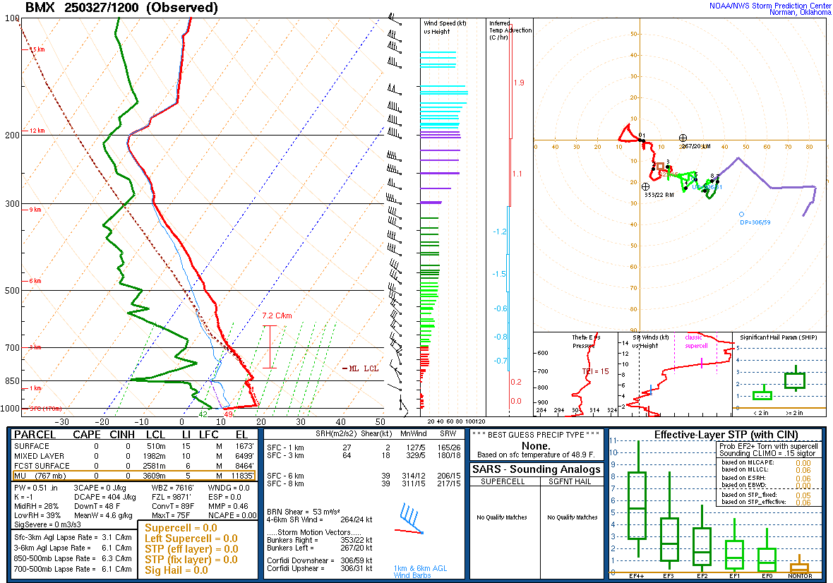


The upper-air soundings from Birmingham, Nashville, and Jackson all show cool, stable air this morning. That is, the soundings are from this morning at 7 AM CDT. I'm writing this close to 6:30 PM CDT. As minor as these details may seem on calm weather days like today, we sure need them nationwide to feed into the computer models and to just plot the hand-drawn upper-air and surface maps too.
Recent events have caused me to realize how much I'd taken such things for granted and scrolled past them with a "meh" attitude. I guess upper-air soundings are sort of like ketchup; you don't miss it until you have nothing to dip your french fries in.
By the way, if anyone out there eats ketchup on your eggs, I'd like to hear from you. Leave me a comment.


Tomorrow looks like another dry day, partly to mostly sunny skies with a High near 78, morning Low near 54.


The GFS is showing moisture making it in here on Saturday, enough for at least some scattered rain.

The NAM has a drier look, and I think it's closer to being right at this time frame, with this system. Look for a High near 76, Low near 59, chance of rain only about 30%. So we could see showers and thunderstorms, but they should stay widely scattered over the region.

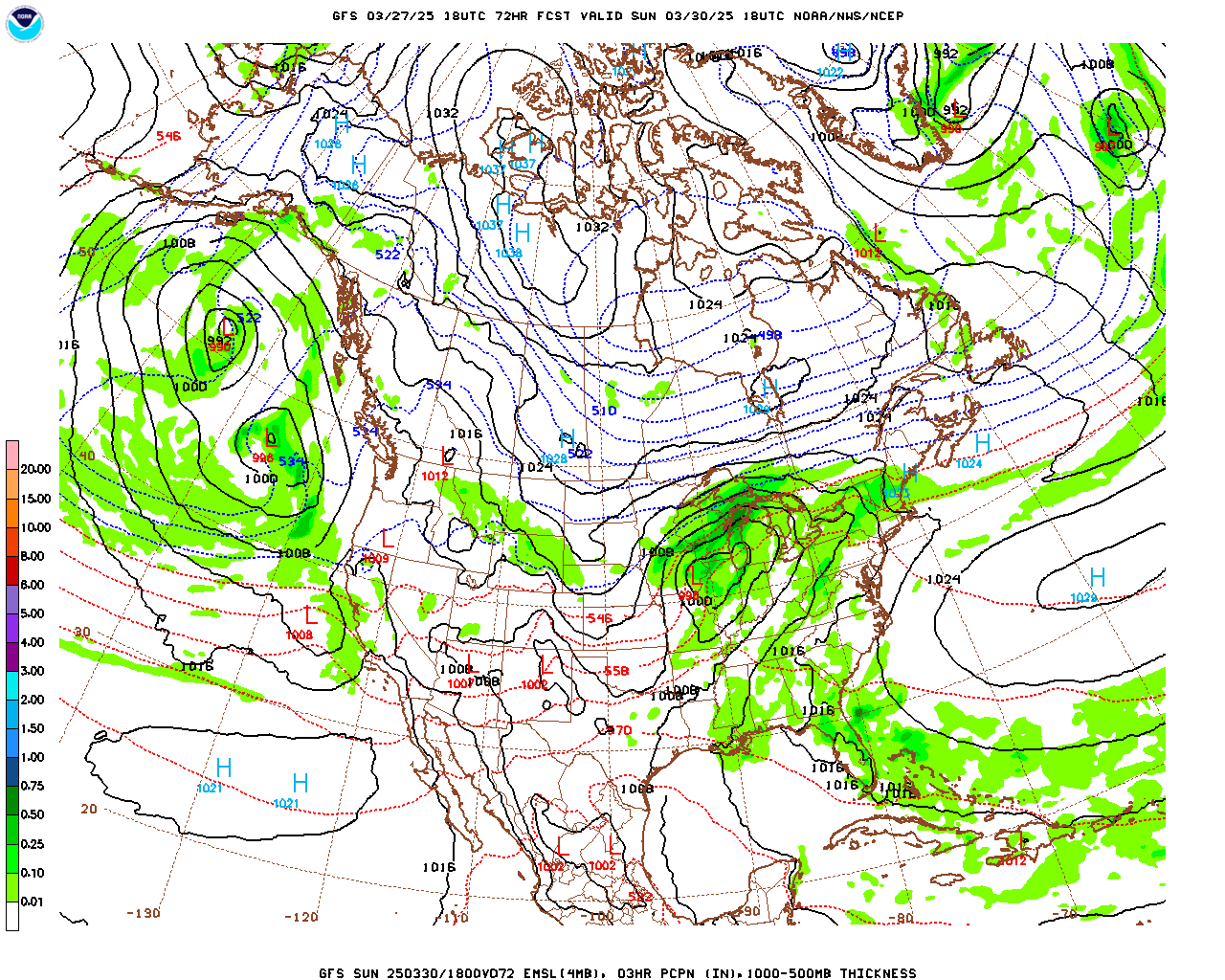
Sunday is the day we've been watching for a while now. The GFS is showing some rain chances during the day but the center of the surface Low way up in Iowa and Minnesota.


Similar look from the ECMWF. It does look like numerous rounds of showers and thunderstorms are possible during the day. From what I've seen so far, these are likely to be "elevated", not surface-based, which means they might produce some hail and maybe some gusty winds, but are not expected to be severe in any organized way during the day. I guess a good analogy would be the storms we had the night of March 14 into the wee hours of that morning, could see some storms try to get that strong, but not looking like a big deal at this point. High should be in the mid-70's, Low near 60.


But then we go to Midnight, or technically 1 AM CDT Monday morning. And both global models, the American and the European, show a line of storms entering the area via Northwest Alabama, a squall line. And this overnight round may very well bring some organized severe weather to us.
We'll look at that in more detail at the bottom, but for now, let's look through the rest of the basic forecast.


This looks like kind of a slow-moving system even as we get into Monday.

The European model is showing things moving through here a little faster, which is the reverse of how it usually is; though it does happen once in a while.
Numerous showers and a few thunderstorms may persist into at least midday Monday if this guidance is right, especially from the GFS. Look for a High in the lower 70's, Low of about 60 or so again.
The severe weather threat appears to be from late Sunday night (around Midnight) through the early morning hours of Monday. I'd be surprised if North Alabama was dealing with it beyond about 8-9 AM.
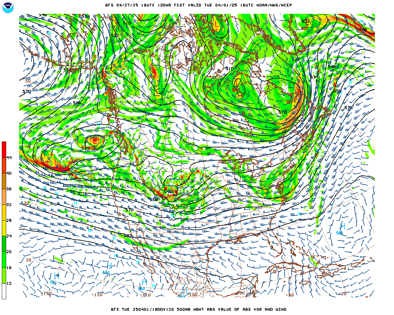

Behind that system on Tuesday we'll be mostly sunny with a High in the lower 70's, the Low in the lower-to-mid-40's.


Then the GFS brings another system in here on Wednesday.


The European model is back to its habit by then, showing a slower timing.
Look for a High near 80, Low in the mid-to-upper-50's as moisture return should happen fairly quickly. Chance of rain should be about 30%.


The GFS has us dry by Thursday. But in this case, at this time range, it's probably got it wrong.


The more unsettled look from the ECMWF is probably closer to the truth here. Will see a High again near 80 or at least upper 70's and a Low near about 60. Chance of rain, will bump up to 40%.
And we have to watch every storm system this time of year in case of any severe thunderstorm potential. At least when our air is staying this warm and unstable. We are nearly into the month of April. All the ingedients have to come together in just the right combination, but we do have to watch things carefully at this prime time of the year for it.

Rainfall totals will probably average about two inches for this forecast period, with locally heavier amounts possible here and there.
MESOSCALE DISCUSSION - SEVERE WEATHER POTENTIAL:

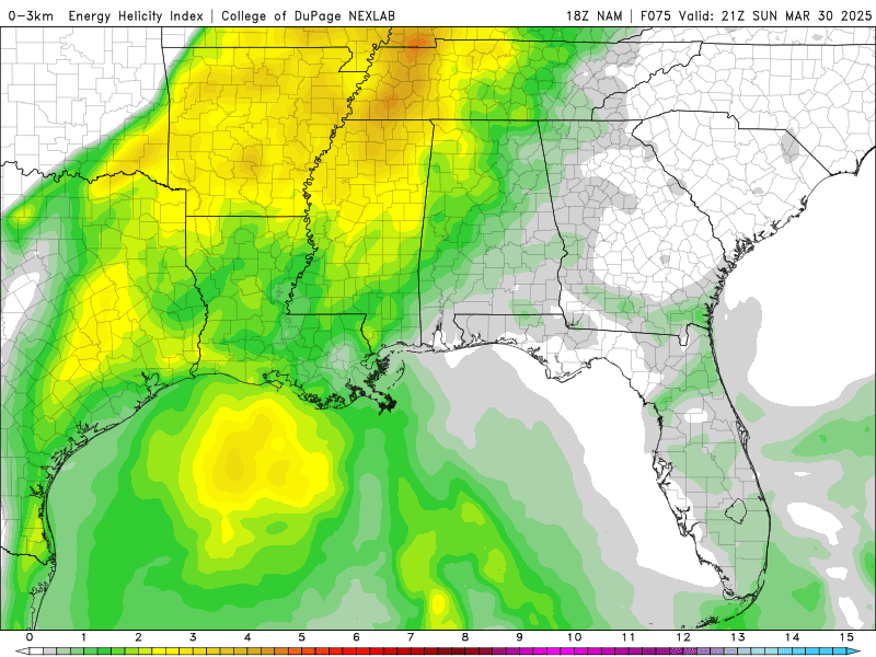


This system is just barely within the reach of the mesoscale models now, so I thought we'd look at the Energy Helicity Index from the NAM (North American Mesoscale) model. Here it is between 1 PM Sunday and 1 AM Monday at three-hour intervals. This is the combination of unstable air and wind shear that we'd look for to pinpoint the most likely areas to see severe thunderstorms.

Taking a forecast sounding at 1 AM going into Monday morning from around Huntsville, we're looking at marginal instability and enough wind shear to work with to support a threat for damaging thunderstorm winds, maybe some hail, and just maybe an isolated tornado or two in the region. This doesn't look overly alarming, but any severe weather threat is worth respecting, especially when it comes overnight.
This setup is tricky. It looks like the atmosphere will stay capped, with an inversion layer of warm air preventing those updrafts from forming and the storms from becoming surface-based, during the day Sunday. If that capping inversion can break anywhere in our area before these overnight hours when the squall line will be approaching, then supercell thunderstorms would be possible with a greater large hail/tornado threat. At the moment, that scenario is not looking likely. But it's something to keep in the back of one's mind.


And that's pretty close to the official Storm Prediction Center outlook, which gives all of us in the TN Valley a 15% basic risk for severe weather Sunday evening through Monday morning. Technically the top outlook is 7 AM to 7 PM Sunday, bottom one from 7 AM to 7 PM Monday. But we can read into this the likely timing of any severe storms, which is Sunday evening, or more likely late at night, through early Monday morning.


.png)
Overall this looks like a typical squall line event, but we have to consider that the air will be unstable during the day Sunday. How much of that lasts into the late night/early Monday morning is a key ingredient in how bad a lot of these storms get.
Main thing is that everybody needs their weather radio on alert with battery backup for this overnight event. Or if you don't have that, at least WEA enabled on a cell phone that will wake you up for a Tornado Warning, in case we have a few of those. Or if it's a PDS Severe Thunderstorm Warning (Particularly Dangerous Situation), WEA tones for that now too. To get most severe thunderstorm warnings, you need a NOAA Weather Radio.
And have a plan. Most people will be at home, but if you're out driving, for work or whatever, try to plan ahead at least 3 or 4 places you could pull over and get inside, away from glass, if a tornado threatened.
Also if you live in a mobile home, you might want to make plans ahead of time so that you can get to a more substantial shelter before this squall line arrives. A tornado can be especially dangerous for people in mobile homes (one death from the March 15 outbreak happened in a mobile home that I remember off the top of my head, here in Alabama, South Alabama), but they are pretty vulnerable to severe thunderstorm winds too, especially if there are trees around.
Buy Me a Coffee
So everybody be safe, and hey, a lot of these Spring days are worth getting out and soaking up the sun. And most of the rain we get isn't going to be associated with severe thunderstorms or a tornado. But it is that time of year when we do have to watch for that sort of thing more than usual. From now to the end of April is often our peak of the year for it. And then things usually gradually settle down in May. Or if you prefer the less dramatic version: "April showers bring May flowers."
8:17 PM footnote - Added severe weather precautions to "notes" section and a Spanish translation of the forecast after skimming back over the whole thing.


No comments:
Post a Comment