Here we go. Going to be a long day.
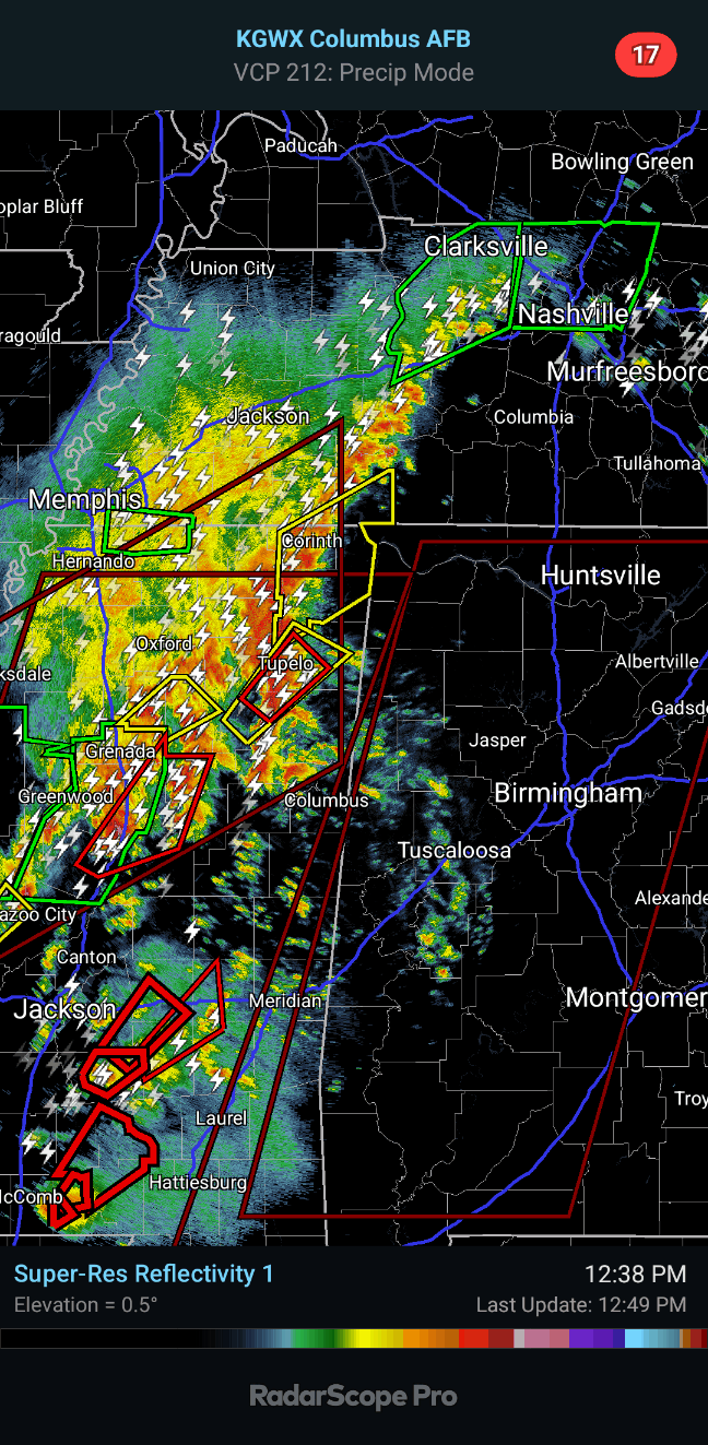
Already got a tornadic supercell moving from Houston, MS toward Tupelo, where they are under a Tornado Warning. People in and around Red Bay in that Northwest corner of Alabama need to be getting ready for that storm, especially if you need to evacuate a mobile home to go to a public shelter. Monitor this storm and leave in plenty of time.
12:31 PM - A separate Tornado Watch will be issued for TN counties soon. Their severe weather threat, including tornado threat, is still pretty substantial, just not quite as high as in AL.
12:33 - People in Franklin and Colbert Counties need to monitor this possible tornado that is currently approaching Tupelo, MS. It could produce a tornado at any moment if it hasn't already.
12:37 - And I believe it is already producing a tornado. There is a lowering in the correlation coefficient co-located with the velocity couplet, which usually means debris is being picked up into the air.
12:49 - This is the broad view. We have to watch all showers and thunderstorms trying to form ahead of the main squall line, even that stuff in West Central Alabama, in case any more become supercellular.
Main storm of concern right now is the tornado, or at least a possible tornado that has shown signs of possible debris on radar at times, coming up on Tupelo. People in Northwest AL, esp around Red Bay, need to be preparing for a tornado. Watching this storm closely.
Nashville is currently under a Flash Flood Warning, and so are some other parts of Tennessee up to Clarksville.
Also got a Severe Thunderstorm Warning that includes Corinth, MS. Folks in TN Counties like Hardin and Wayne want to watch that storm, which is part of the main squall line.
12:54 - And now a Severe Thunderstorm Warning has been issued for Lauderdale, Colbert, and Franklin Counties in Northwest AL. It includes a note that a tornado could quickly develop from this bunch of thunderstorms moving in, even though the main threat for now is 60 mph wind gusts and hail about quarter-sized.
12:56 - And here's our TN Tornado Watch.
12:57 - Better visual on the new Severe T-Storm Warning. Also note a warning has been issued that includes McNairy and Hardin Counties on the TN side for same bunch of storms in squall line.
1:01 PM - That storm a little Southeast of Tupelo continues to show rotation but no longer showing a debris signature. Tornado Warning continues for next 12 minutes.
1:16 - Meanwhile the Tornado Warning near Tupelo was allowed to expire, and Severe Thunderstorm Warnings extend to the AL state line, including Amory, MS.
These are along the main squall line that is slowly advancing East even as the storms within it moves more Southwest to Northeast.
The storms we really need to watch most (although all can be dangerous) are the discrete supercells that are forming ahead of the squall line and will track Northeast. Those have the highest tornado threat.
1:21 - We have a possible tornado near Amory now. Folks in Northwest Alabama, be watching this. If a tornado touches down, it could do significant damage.
1:24 - There is a more concerning supercell back in Montgomery County, MS that is likely to eventually affect NW AL and could produce a significant tornado. The squall line has broken up back there, and that storm is a discrete supercell.
1:29 - Brad Travis
has a live stream going. Earlier I was watching Matt Laubhan. It varies from one event to the next. Sometimes I even watch Ryan Hall, who usually does a good job, sometimes a very good job. I know opinions on him vary.
1:31 - Okay, that tornado just across the MS state line is CONFIRMED. People in Northwest Alabama, be getting ready for it.
Tornado Warning Marion County - NEW POST coming.
SEL6
URGENT - IMMEDIATE BROADCAST REQUESTED
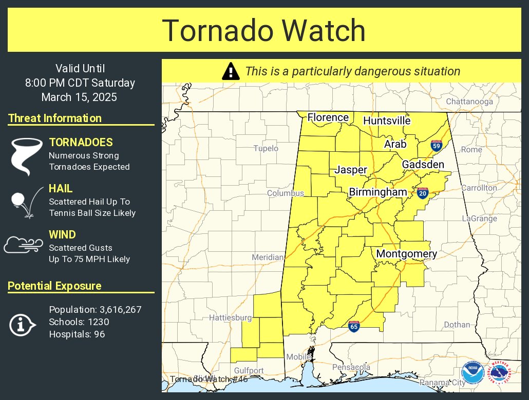
Tornado Watch Number 46
NWS Storm Prediction Center Norman OK
1225 PM CDT Sat Mar 15 2025
The NWS Storm Prediction Center has issued a
* Tornado Watch for portions of
Western, Central, and Northern Alabama
Southeast Mississippi
* Effective this Saturday afternoon and evening from 1225 PM
until 800 PM CDT.
...THIS IS A PARTICULARLY DANGEROUS SITUATION...
* Primary threats include...
Numerous tornadoes and several intense tornadoes expected
Scattered damaging winds and isolated significant gusts to 75
mph likely
Scattered large hail and isolated very large hail events to 2.5
inches in diameter likely
SUMMARY...Intense supercells capable of producing numerous tornadoes
will spread eastward from Mississippi into Alabama this afternoon
and evening. Given the very favorable environment, multiple intense
to potentially violent tornadoes (EF-3/EF-4+) appear possible.
Clusters of thunderstorms and embedded supercells will also pose a
threat for severe/damaging winds of 60-75 mph, and large hail around
1.5-2.5 inches in diameter.
The tornado watch area is approximately along and 65 statute miles
east and west of a line from 20 miles north northeast of Huntsville
AL to 55 miles west southwest of Evergreen AL. For a complete
depiction of the watch see the associated watch outline update
(WOUS64 KWNS WOU6).
PRECAUTIONARY/PREPAREDNESS ACTIONS...
REMEMBER...A Tornado Watch means conditions are favorable for
tornadoes and severe thunderstorms in and close to the watch
area. Persons in these areas should be on the lookout for
threatening weather conditions and listen for later statements
and possible warnings.
&&
OTHER WATCH INFORMATION...CONTINUE...WW 44...WW 45...
AVIATION...Tornadoes and a few severe thunderstorms with hail
surface and aloft to 2.5 inches. Extreme turbulence and surface wind
gusts to 65 knots. A few cumulonimbi with maximum tops to 500. Mean
storm motion vector 23040.
...Gleason
WOUS64 KWNS 151722
WOU6
BULLETIN - IMMEDIATE BROADCAST REQUESTED
TORNADO WATCH OUTLINE UPDATE FOR WT 46
NWS STORM PREDICTION CENTER NORMAN OK
1225 PM CDT SAT MAR 15 2025
TORNADO WATCH 46 IS IN EFFECT UNTIL 800 PM CDT FOR THE
FOLLOWING LOCATIONS
ALC001-007-009-013-015-021-023-025-033-035-037-043-047-049-051-
055-057-059-063-065-071-073-075-077-079-083-085-089-091-093-095-
099-101-103-105-107-115-117-119-121-125-127-129-131-133-
160100-
/O.NEW.KWNS.TO.A.0046.250315T1725Z-250316T0100Z/
AL
. ALABAMA COUNTIES INCLUDED ARE
AUTAUGA BIBB BLOUNT
BUTLER CALHOUN CHILTON
CHOCTAW CLARKE COLBERT
CONECUH COOSA CULLMAN
DALLAS DEKALB ELMORE
ETOWAH FAYETTE FRANKLIN
GREENE HALE JACKSON
JEFFERSON LAMAR LAUDERDALE
LAWRENCE LIMESTONE LOWNDES
MADISON MARENGO MARION
MARSHALL MONROE MONTGOMERY
MORGAN PERRY PICKENS
SHELBY ST. CLAIR SUMTER
TALLADEGA TUSCALOOSA WALKER
WASHINGTON WILCOX WINSTON
MSC039-041-111-131-153-160100-
/O.NEW.KWNS.TO.A.0046.250315T1725Z-250316T0100Z/
MS
. MISSISSIPPI COUNTIES INCLUDED ARE
GEORGE GREENE PERRY
STONE WAYNE
ATTN...WFO...BMX...MOB...HUN...
#
Particularly Dangerous Situation Watch coming for us within the hour.
In other words, it's on.
Everybody stay safe. Take care of each other.
Mesoscale Discussion 0200
NWS Storm Prediction Center Norman OK
1119 AM CDT Sat Mar 15 2025
Areas affected...extreme southeast Mississippi into much of western
and central Alabama
Concerning...Severe potential...Tornado Watch likely
Valid 151619Z - 151745Z
Probability of Watch Issuance...95 percent
SUMMARY...The severe threat will increase through the afternoon,
including the potential for multiple intense, destructive tornadoes.
A Particularly Dangerous Situation Tornado Watch will be issued in
the next hour.
DISCUSSION...Thunderstorms, including supercells, continue to
increase in coverage and intensity over in MS with the rapid
approach of a potent mid-level trough. A pronounced 500 mb speed max
will glance the region to the west, promoting the maintenance of
ongoing storms, while also contributing to adequate deep-layer
ascent for the development of new supercells in warm-sector
confluence bands. As this occurs, these supercells will mature in a
moistening low-level airmass, with dewpoints in the mid 60s F,
overspread by 8 C/km mid-level lapse rates. MLCAPE should reach
around 2000 J/kg amid 400+ m2/s2 effective SRH (driven by large,
elongated/curved hodographs that are already evident via regional
VADs). The anticipated parameter space will be highly supportive of
tornadic supercells. The more discrete, dominant supercell
structures will be capable of intense, destructive tornadoes, and
violent tornadoes cannot be ruled out. A severe hail/wind threat
should also accompany any robust, sustained thunderstorms. A
Particularly Dangerous Situation Tornado Watch will be needed in the
next hour to address the impending severe threat.
..Squitieri/Gleason.. 03/15/2025
...Please see www.spc.noaa.gov for graphic product...
ATTN...WFO...BMX...HUN...MOB...LIX...
LAT...LON 31468689 30738738 30418812 30488903 30678929 31118899
31568843 32138842 34508792 34888771 34938686 34598605
33918572 33108579 32258622 31468689


No comments:
Post a Comment