


Expecting a similar watch including Alabama and at least parts of Southern Tennessee by some time this afternoon.
SEL5
URGENT - IMMEDIATE BROADCAST REQUESTED
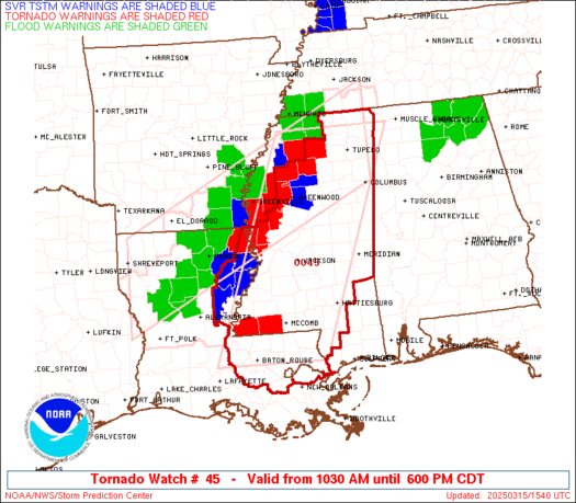
Tornado Watch Number 45
NWS Storm Prediction Center Norman OK
1030 AM CDT Sat Mar 15 2025
The NWS Storm Prediction Center has issued a
* Tornado Watch for portions of
Eastern Louisiana
Mississippi
Coastal Waters
* Effective this Saturday morning and evening from 1030 AM until
600 PM CDT.
...THIS IS A PARTICULARLY DANGEROUS SITUATION...
* Primary threats include...
Numerous tornadoes and several intense tornadoes expected
Scattered damaging winds and isolated significant gusts to 75
mph likely
Scattered large hail and isolated very large hail events to 2.5
inches in diameter likely
SUMMARY...Multiple supercells are expected late this morning through
early evening from eastern Louisiana into much of Mississippi. With
a very favorable environment in place, numerous tornadoes are
expected, including the potential for multiple intense to violent
tornadoes (EF3-4+). Scattered large hail up to 1.5-2.5 inches in
diameter and damaging winds of 60-75 mph will also be a threat as
these thunderstorms move northeastward.
The tornado watch area is approximately along and 70 statute miles
east and west of a line from 55 miles south southwest of Mc Comb MS
to 35 miles northeast of Oxford MS. For a complete depiction of the
watch see the associated watch outline update (WOUS64 KWNS WOU5).
PRECAUTIONARY/PREPAREDNESS ACTIONS...
REMEMBER...A Tornado Watch means conditions are favorable for
tornadoes and severe thunderstorms in and close to the watch
area. Persons in these areas should be on the lookout for
threatening weather conditions and listen for later statements
and possible warnings.
&&
OTHER WATCH INFORMATION...CONTINUE...WW 44...
AVIATION...Tornadoes and a few severe thunderstorms with hail
surface and aloft to 2.5 inches. Extreme turbulence and surface wind
gusts to 65 knots. A few cumulonimbi with maximum tops to 500. Mean
storm motion vector 24040.
...Gleason
WOUS64 KWNS 151529
WOU5
BULLETIN - IMMEDIATE BROADCAST REQUESTED
TORNADO WATCH OUTLINE UPDATE FOR WT 45
NWS STORM PREDICTION CENTER NORMAN OK
1030 AM CDT SAT MAR 15 2025
TORNADO WATCH 45 IS IN EFFECT UNTIL 600 PM CDT FOR THE
FOLLOWING LOCATIONS
LAC005-025-029-033-035-037-041-047-063-065-077-091-093-095-103-
105-107-117-121-125-152300-
/O.NEW.KWNS.TO.A.0045.250315T1530Z-250315T2300Z/
LA
. LOUISIANA PARISHES INCLUDED ARE
ASCENSION CATAHOULA CONCORDIA
EAST BATON ROUGE EAST CARROLL EAST FELICIANA
FRANKLIN IBERVILLE LIVINGSTON
MADISON POINTE COUPEE ST. HELENA
ST. JAMES ST. JOHN THE BAPTISTST. TAMMANY
TANGIPAHOA TENSAS WASHINGTON
WEST BATON ROUGE WEST FELICIANA
MSC001-003-005-007-009-013-015-017-019-021-023-025-029-031-035-
037-043-049-051-053-055-057-061-063-065-067-069-071-073-075-077-
079-081-083-085-087-089-091-095-097-099-101-103-105-109-113-115-
117-121-123-125-127-129-135-139-141-145-147-149-155-157-159-161-
163-152300-
/O.NEW.KWNS.TO.A.0045.250315T1530Z-250315T2300Z/
MS
. MISSISSIPPI COUNTIES INCLUDED ARE
ADAMS ALCORN AMITE
ATTALA BENTON CALHOUN
CARROLL CHICKASAW CHOCTAW
CLAIBORNE CLARKE CLAY
COPIAH COVINGTON FORREST
FRANKLIN GRENADA HINDS
HOLMES HUMPHREYS ISSAQUENA
ITAWAMBA JASPER JEFFERSON
JEFFERSON DAVIS JONES KEMPER
LAFAYETTE LAMAR LAUDERDALE
LAWRENCE LEAKE LEE
LEFLORE LINCOLN LOWNDES
MADISON MARION MONROE
MONTGOMERY NESHOBA NEWTON
NOXUBEE OKTIBBEHA PEARL RIVER
PIKE PONTOTOC PRENTISS
RANKIN SCOTT SHARKEY
SIMPSON SMITH TALLAHATCHIE
TIPPAH TISHOMINGO UNION
WALTHALL WARREN WEBSTER
WILKINSON WINSTON YALOBUSHA
YAZOO
GMZ530-152300-
/O.NEW.KWNS.TO.A.0045.250315T1530Z-250315T2300Z/
CW
. ADJACENT COASTAL WATERS INCLUDED ARE
LAKE PONTCHARTRAIN AND LAKE MAUREPAS
ATTN...WFO...LIX...JAN...MEG...


No comments:
Post a Comment