


For this one, we've got a broken sort of squall line prompting numerous Tornado Warnings back in Arkansas and Missouri. And there are supercells getting their act together ahead of it in this new watch that covers Northern Mississippi and roughly the Western third of Tennessee. This goes until 3 AM.
Posing this a few hours after it actually came out. This is going to be a long-duration event locally with two rounds. My weather radio only alerts for Cullman, Walker, and Winston Counties in Alabama. So any watches outside of those areas, I have to catch on my own by checking on it when awake. And I had zonked a while and then woke up. But this is a PDS Watch for our immediate neighbors over in MS where the threat for tornadoes is listed as high, including the risk for stronger tornadoes. They could see extra-large hail and significant straight-line winds damage too. The storms of greatest concern tonight are the supercells that stay isolated, those are more dangerous. And those are mostly what we expect to see over here during the main event tomorrow.
But we could see some tonight. Will have to see how this storms behave as they move through Mississippi and into Alabama/Middle Tennessee. Probably our greatest risk tonight is West of I-65. Tomorrow once the daytime event gets going, all of us have a significant risk for severe weather, including tornadoes, some of which could be very damaging.

Many reports of large hail and damaging winds across the Midwest already, and five tornado reports, all in Missouri. Looks like one tornado just did tree and power line damage, but the others did a lot of structural damage, like was expected with this event. Even well-built houses can sustain significant damage in these kinds of setups. And everybody has to take them seriously.
At some point between now and 3 AM a watch will likely be considered for Northwest Alabama.
11:16 PM - Thought we'd look at forecast soundings from 7 PM earlier this evening.

Jackson, Mississippi had a temperature of 80, dewpoint of 62, long/curved hodographs. Surface-based CAPE was over 1,500 j/kg which is pretty strong instability. Lifted Index was a -7, also showing pretty strong instability. Storm Relative Helicity was over 250 units at 3 kilometers, at 120 units at lowest 1 km. So already their environment at 7 PM was supporting organized severe weather, including tornadoes. Supercell Composite was 8.2 and Significant Tornado Parameter at about a value of 1.


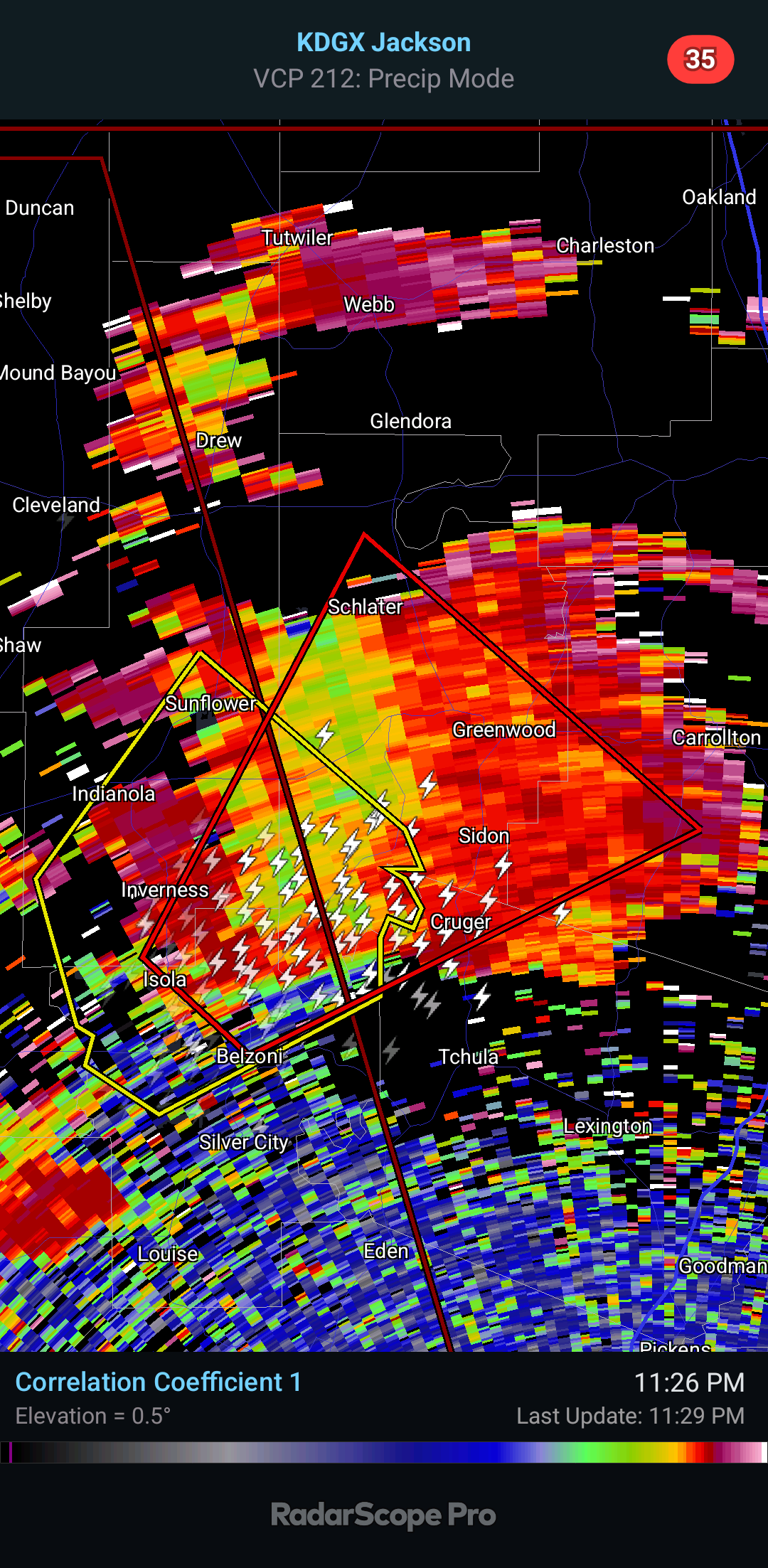


The correlation coefficient is not showing any really strong debris signature, but those bottom two graphics. it has a tight velocity couplet where the green and red colors show winds blowing in opposite directions. And on the regular reflectivity, this is a classic tornadic supercell with a hook echo and a strong hail core out ahead of that to the Northeast, also lots of lightning like you expect in a storm like this.
SEL6
URGENT - IMMEDIATE BROADCAST REQUESTED
Tornado Watch Number 36
NWS Storm Prediction Center Norman OK
730 PM CDT Fri Mar 14 2025
The NWS Storm Prediction Center has issued a
* Tornado Watch for portions of
Northeast Arkansas
Southern Illinois
Far Southwest Indiana
Western Kentucky
Southeast Missouri
Northern Mississippi
Western Tennessee
* Effective this Friday night and Saturday morning from 730 PM
until 300 AM CDT.
...THIS IS A PARTICULARLY DANGEROUS SITUATION...
* Primary threats include...
Several tornadoes and a few intense tornadoes likely
Widespread damaging winds and scattered significant gusts to 80
mph likely
Scattered large hail and isolated very large hail events to 2.5
inches in diameter likely
SUMMARY...Severe thunderstorms are expected to develop across the
watch area over the next several hours. Environmental conditions are
very favorable for supercells capable of all severe hazards,
including very large hail (i.e. greater than 2" in diameter) and
strong (EF2+) tornadoes. If storms can remain discrete, potential
exists for a few long-track tornadoes.
The tornado watch area is approximately along and 75 statute miles
east and west of a line from 40 miles west northwest of Evansville
IN to 25 miles southwest of Oxford MS. For a complete depiction of
the watch see the associated watch outline update (WOUS64 KWNS
WOU6).
PRECAUTIONARY/PREPAREDNESS ACTIONS...
REMEMBER...A Tornado Watch means conditions are favorable for
tornadoes and severe thunderstorms in and close to the watch
area. Persons in these areas should be on the lookout for
threatening weather conditions and listen for later statements
and possible warnings.
&&
OTHER WATCH INFORMATION...CONTINUE...WW 31...WW 32...WW 33...WW
34...WW 35...
AVIATION...Tornadoes and a few severe thunderstorms with hail
surface and aloft to 2.5 inches. Extreme turbulence and surface wind
gusts to 70 knots. A few cumulonimbi with maximum tops to 500. Mean
storm motion vector 24035.
...Mosier


No comments:
Post a Comment