People in Athens or anywhere in this polygon, be sheltered. Can't take chances today.
From Athens up to Elkmont up to Ardmore, anywhere near there, be sheltered - small central room on the lowest floor of a sturdy house, away from windows - not in a mobile home.
3:30 PM - This storm weakened quickly enough that the warning was allowed to expire.
A Severe Thunderstorm Warning remains in effect for Limestone County as well as Lincoln, Moore, and Franklin Counties in Tennessee. Damaging wind gusts and large hail are possible, and a tornado could spin up quickly in this environment as well.
We've got a Tornado Warning in TN for a storm South of Murfreesboro and a much more concerning tornadic rotation that has prompted a warning for Northern Tuscaloosa County in West Central Alabama. Folks in Walker County will want to watch that, as it is a long-track supercell trying to produce a tornado.
3:37 - Looks like Wayne County, TN and points West have been cleared from the Tornado Watch.
Lawrence and Giles Counties are having flash flooding issues, as are Lauderdale, Colbert, and Franklin Counties in NW AL.
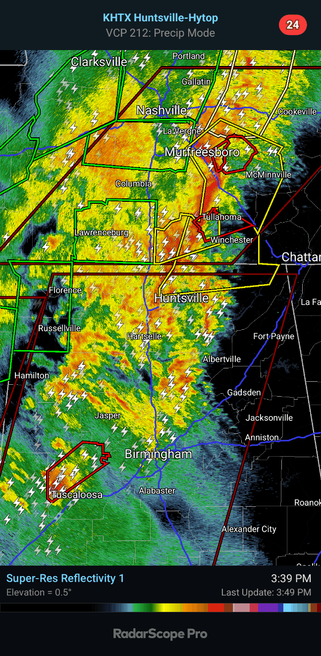
3:39 - Got a Tornado Warning for Lincoln, Moore, and Franklin Counties in TN just now. Not going to start a new post for it as it looks short-fused, but will post updates here.
3:40 - From Lynchburg over to Estill Springs, people need to go to shelter and stay there while this rotating part of this line of storms passes. Started to make a new post for this, but it's not an isolated supercell. And the rotation is not the tightest. I'd still advise sheltering and assuming this is on the ground as a tornado. Even if not, damaging winds are likely in this storm. And it's better to play it safe, especially on a day like today.
3:43 - Meanwhile to the South, we have a confirmed tornado moving into Northern Tuscaloosa County. We need to keep an eye on this one, could produce significant damage. People in at least Southern Walker County will want to monitor its progress.
3:50 - And we have a new Severe Thunderstorm Warning for Northern Madison and Jackson Counties, Eastern Lincoln, Moore, and Franklin Counties in Tennessee. This is for 60 mph wind gusts. But a tornado could develop quickly in this atmosphere as well, that's a note they put on the warning.
Showing the broad view since it's kind of a busy map as we approach the top of another hour.
3:53 - Here's more of a closeup.
3:54 - Report from trained spotter about the Tuscaloosa County tornado, when it passed near Elrod, the spotter at 3:41 saw it cross US-82 near Minas Road. Trees were snapped and uprooted, and at least one home had roof damage.
3:59 - That tornado is likely to affect Southern Walker County and maybe up toward places like Warrior within the next 30-45 minutes.
Places like Dora, Sumiton, I'd definitely be watching this.
4:04 PM - That tornado warning for Franklin and Moore Counties in TN is cancelled.
If and when they extend that Tornado Warning into Walker and maybe Jefferson County, I'm going to start a new post for it, because that storm may affect North Alabama, may hang together and could be a significant storm, produced a confirmed tornado earlier. Though damage reports have been sparse, I think I only saw the one.
4:18 - As of 4:14 the NWS Birmingham is calling this a confirmed tornado again. It is near Bankhead Lock and Dam headed for Wiley, Windham Springs, and Whitson.
4:20 - People in places like Parrish, Sumiton, Dora, be getting ready. You may be under a warning soon for this storm that has had a confirmed tornado, history of that.
Here it is - new post coming.
780
WFUS54 KHUN 152006
TORHUN
ALC083-152030-
/O.NEW.KHUN.TO.W.0016.250315T2006Z-250315T2030Z/
BULLETIN - EAS ACTIVATION REQUESTED
Tornado Warning
National Weather Service Huntsville AL
306 PM CDT Sat Mar 15 2025
The National Weather Service in Huntsville Alabama has issued a
* Tornado Warning for...
Northern Limestone County in north central Alabama...
* Until 330 PM CDT.
* At 306 PM CDT, a severe thunderstorm capable of producing a tornado
was located 9 miles northwest of Athens, moving northeast at 35
mph.
HAZARD...Tornado.
SOURCE...Radar indicated rotation.
IMPACT...Flying debris will be dangerous to those caught without
shelter. Mobile homes will be damaged or destroyed.
Damage to roofs, windows, and vehicles will occur. Tree
damage is likely.
* This dangerous storm will be near...
Athens around 310 PM CDT.
Other locations impacted by this tornadic thunderstorm include Good
Springs, Cartwright, Coxey, Cairo, Holland Gin, Mt Rozell, Leggtown,
Elkmont, and Ripley.
PRECAUTIONARY/PREPAREDNESS ACTIONS...
TAKE COVER NOW! Move to a basement or an interior room on the lowest
floor of a sturdy building. Avoid windows. If you are outdoors, in a
mobile home, or in a vehicle, move to the closest substantial shelter
and protect yourself from flying debris.
Heavy rainfall may hide this tornado. Do not wait to see or hear the
tornado. TAKE COVER NOW!
&&
LAT...LON 3499 8707 3499 8678 3485 8678 3474 8715
3487 8722 3494 8721 3500 8714
TIME...MOT...LOC 2006Z 242DEG 32KT 3484 8710
TORNADO...RADAR INDICATED
MAX HAIL SIZE...<.75 IN
$$
AMP


No comments:
Post a Comment