


This clips the city of Cullman, includes Good Hope, Dodge City, Bremen, Colony, Hanceville, Garden City. All the way up to Fairview, Baileyton, and Holly Pond. They are giving plenty of lead time as this comes out of Walker County.
Need to get in a small central room on the lowest floor of a sturdy house, away from windows. And cover your head as best you can - helmet if you can.
And of course if you have a storm shelter, go there.
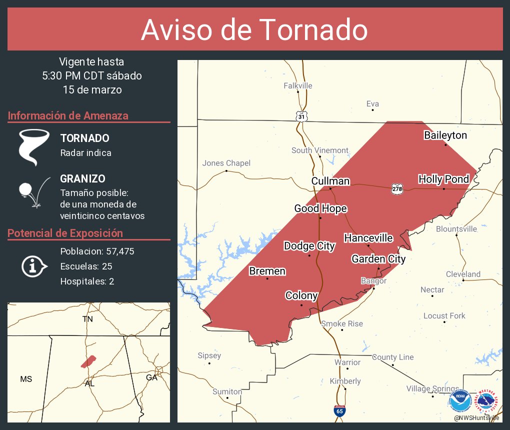
4:58 PM - Anywhere in this polygon, be sheltered. Even in the city of Cullman, to be on the safe side, get to shelter and stay there.
5:03 PM - Radar update. Even the city of Cullman but certainly around Hanceville, everybody be sheltered.
Radar not loading but James Spann just showed a video that there was a confirmed tornado with this earlier in Walker County, you could see power flashes.
Here is his live stream.
Sipsey firefighter confirmed this tornado with damage also.
5:08 - Everyone all the way up to Baileyton and Holly Pond needs to stay sheltered - this is a CONFIRMED TORNADO!

5:22 - The rotation cycles up and down and is somewhat broad at the moment but folks up toward Baileyton be in shelter. Cullman and points South and East in the county I'd stay sheltered just out of respect for this storm. A secondary circulation could spin up. Fairview, Baileyton, Joppa, stay sheltered.
By the way, folks in Arab, be getting ready to shelter if a warning is required for you soon.

5:25 - Got a new tornado warning that includes Florence and Tuscumbia.
So that's Central Lauderdale and SE Colbert County until 6 PM.

5:27 - Now we have a Severe Thunderstorm Warning extended into Marshall County including Arab. With a note that a tornado is also possible.
165
WFUS54 KHUN 152144
TORHUN
ALC043-152230-
/O.NEW.KHUN.TO.W.0018.250315T2144Z-250315T2230Z/
BULLETIN - EAS ACTIVATION REQUESTED
Tornado Warning
National Weather Service Huntsville AL
444 PM CDT Sat Mar 15 2025
The National Weather Service in Huntsville Alabama has issued a
* Tornado Warning for...
Central Cullman County in north central Alabama...
* Until 530 PM CDT.
* At 444 PM CDT, a severe thunderstorm with a history of producing a
tornado was located over Lynns Park, or near Cordova, moving
northeast at 55 mph.
HAZARD...Tornado and quarter size hail.
SOURCE...Radar indicated rotation.
IMPACT...Flying debris will be dangerous to those caught without
shelter. Mobile homes will be damaged or destroyed.
Damage to roofs, windows, and vehicles will occur. Tree
damage is likely.
* This dangerous storm will be near...
Dodge City around 505 PM CDT.
Good Hope and Hanceville around 510 PM CDT.
Cullman around 515 PM CDT.
Holly Pond around 525 PM CDT.
Other locations impacted by this tornadic thunderstorm include
Phelan, Walter, Wilburn, Bremen, Arkadelphia, Baileyton, Black
Bottom, Colony, Garden City, and Smith Lake.
PRECAUTIONARY/PREPAREDNESS ACTIONS...
TAKE COVER NOW! Move to a basement or an interior room on the lowest
floor of a sturdy building. Avoid windows. If you are outdoors, in a
mobile home, or in a vehicle, move to the closest substantial shelter
and protect yourself from flying debris.
&&
LAT...LON 3389 8701 3390 8710 3391 8708 3393 8710
3431 8673 3431 8666 3421 8655 3412 8660
3412 8663 3409 8668 3409 8669 3405 8668
3406 8671 3403 8670 3395 8679 3391 8692
3387 8693 3386 8699
TIME...MOT...LOC 2144Z 224DEG 47KT 3379 8715
TORNADO...RADAR INDICATED
MAX HAIL SIZE...1.00 IN
$$
25


No comments:
Post a Comment