

FORECAST:
Friday (High 78, Low 56): Partly cloudy, warm, and windy during the day. Thunderstorms are likely late at night - possibly severe.
Saturday (High 75, Low 61): Severe thunderstorms likely across the region throughout the day and night. Tornadoes possible.
Sunday (High 65, Low 53): Mostly sunny. Cooler.
EXTENDED OUTLOOK:
Monday (High 66, Low 36): Sunny.
Tuesday (High 72, Low 39): Sunny.
Wednesday (High 73, Low 50): Partly cloudy with a 30% chance of showers/thunderstorms.
Thursday (High 60, Low 43): Partly to mostly sunny with a 20% chance of showers.
PRONÓSTICO:
Viernes (Máxima 78, Mínima 56): Parcialmente nublado, cálido y ventoso durante el día. Se esperan tormentas eléctricas a altas horas de la noche, posiblemente severas.
Sábado (Máxima 75, Mínima 61): Probabilidad de tormentas eléctricas severas en la región durante el día y la noche. Posibles tornados.
Domingo (Máxima 65, Mínima 53): Mayormente soleado. Más fresco.
PERSPECTIVA EXTENDIDA:
Lunes (Máxima 66, Mínima 36): Soleado.
Martes (Máxima 72, Mínima 39): Soleado.
Miércoles (Máxima 73, Mínima 50): Parcialmente nublado con un 30 % de probabilidad de lluvias/tormentas eléctricas.
Jueves (Máxima 60, Mínima 43): Parcialmente soleado con un 20 % de probabilidad de lluvias.
Review your tornado safety plan before we start having problems tomorrow night or Saturday. Make sure your family or any friends visiting all understand it.
We have a "blood moon" lunar eclipse tonight, if the clouds break up enough to allow for viewing.
If you've ever wanted to be trained as a storm spotter, please consider taking a SKYWARN class this season. They're free. And it helps everyone when we have more reliable spotters in the network.
DISCUSSION:

We currently have some thunderstorms moving through Cullman County, also some still back in Winston County, over in Blount County, stretching up through Marshall, Morgan, and Southern Madison Counties. Then there are a few scattered showers and thunderstorms up in Tennessee. All of these are under severe limits.
But earlier today, we did have a few thunderstorms that required Severe Thunderstorm Warnings in Marion County and later in Winston and Lawrence Counties, mainly for the threat of large hail. I think at one point, a warning may have included Colbert and Franklin Counties in Northwest Alabama too. So today's Level 1 Marginal Risk from the SPC for some hail and severe wind gust potential did verify after all.

The reports of hail did stay very isolated, but that's what that marginal risk means.
And we are sort of in the calm before the real storm. This weekend looks really rough.


What we've had today is associated with an upper-level trough (that dip you see in our region on the third map from the top of this stack above) moving through. But what we're watching is that much stronger storm system that is still West of the Rocky Mountains. That is going to bring a significant outbreak of severe weather to a lot of people, and we in North Alabama and Southern Middle Tennessee are in the core of the areas most likely to be affected.


Here are the upper-air soundings from 7 AM this morning at Birmingham, Nashville, and Jackson (MS). Again, even with a few storms around today, we're really in the calm before the big storms.
It's about 7:30 PM CDT as I'm writing this, and we still have a thunderstorm in the vicinity in Cullman, some rain/fog/mist. And we are at 61 degrees. The dewpoint is also 61, making the relative humidity 100%. Winds are from the East at 6 miles per hour. The pressure is 29.90 inches and rising at the moment. Visibility has come down to 4 miles from this storm and all the rain and fog. The High today was 73, and the Low was 57.
It is mostly cloudy in Jasper with a temperature of 72 degrees. The dewpoint is 55 degrees, making the relative humidity 57%. Winds are calm at the moment. The pressure is 29.85 inches and rising slowly at the moment. The visibility is 10 miles. The High today was 79, and the Low was 50.
Haleyville is mostly cloudy, and they were in that Severe Thunderstorm Warning earlier, within the past couple hours, but now the rain has moved out, and just mostly cloudy skies. The temperature is 60 degrees with a dewpoint of 55 degrees, making the relative humidity 84%. Winds are from the East at 3 mph. The pressure is 29.87 inches/987.5 millibars and rising slowly for the time being. As always, thanks to Haleyville for providing their pressure in millibars as well as inches, since that's what is used on the real weather maps. Visibility is 10 miles there. The High today was 74, and the Low was 56.
Elsewhere around the region, Fort Payne had a High of 73 and a Low of 44 today. Scottsboro had a High of 75 and Low of 48. Decatur saw a High of 76 and Low of 54. Huntsville had a High of 73 and Low of 55. Muscle Shoals had a High of 77 and Low of 59. Tupelo had a High of 78 and Low of 59. Memphis saw a High of 77 and Low of 59. Winchester had a High of 77 and Low of 50. And Nashville saw a High of 79 and a Low of 57 today.


So that next cold front is currently West of the Rockies causing mixed wintry precipitation over several states along with a deep Low pressure system. Over the next couple days, it is going to move rapidly to the East and bring our region a severe weather outbreak that looks like it will come in two distinct rounds, one Friday night and another during the day on Saturday.


Tomorrow that strong Low pressure system will be moving through the Plains.


And it will bring with it potential for a widespread outbreak of severe thunderstorms and tornadoes. This SPC outlook runs until 7 AM Saturday, and areas in Alabama and Tennessee are at risk for severe weather, including tornadoes, from this first round late tomorrow night into early Saturday morning. Areas most likely to get severe weather are along and West of I-65 from this first round.
Most of the day tomorrow though should just be partly cloudy, warm, and sort of windy - winds could gust up to the 15-25 mph range. Winds will be out of the South/Southeast. The High temperature should get up to about 78 after a morning Low near 56.


Then Saturday that front will move through our area. Basically any time of day is fair game for severe weather in a setup as volatile as this. But most likely, our first round (from Friday night) will be winding down around Daybreak Saturday morning. And then our second round, where we expect supercell thunderstorms capable of tornadoes, large hail, and damaging winds, should mainly be Saturday afternoon, but may start as early as midday, and may last into the night hours before the final squall line comes through just ahead of the front. So we've got a wide window of time that we need to be alert for severe weather. And this is a dangerous setup where some places could experience significant damage.
That secondary surface Low over the Mid-South sure isn't doing us any favors. And look at those strong upper-level winds pulling up so much Gulf moisture. That's why a strong combination of unstable air and wind shear is expected with this.

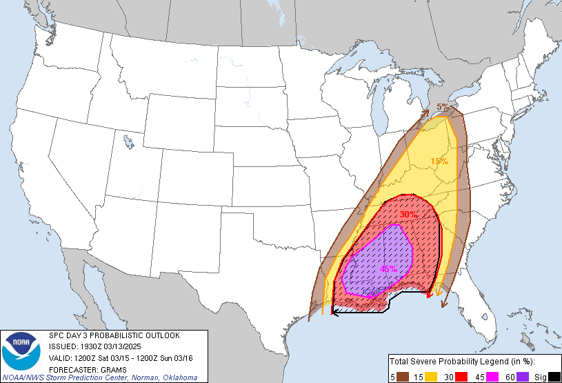
And the Storm Prediction Center has expanded their outlook so that much of North Alabama is now included in a 45% risk for significant severe weather. That means about a 50/50 shot of any one spot getting a supercell thunderstorm that could produce a particularly damaging tornado, very large hail, or really damaging winds (up to hurricane force). And then the rest of the area is under a 30% hatched area, so about a 30% chance of a supercell thunderstorm like that affecting any one spot. The last time I can remember probabilities this threatening was in March of 2021, when we had two tornado outbreaks about a week apart.
Anyway, it looks like a High of about 73-75 on Saturday, the Low about 61-63. But severe thunderstorms are likely.


Then Sunday looks mostly sunny with a High in the lower, maybe mid-60's, the Low in the lower 50's.
And I'm just going to quickly broad-brush the extended forecast since our immediate weather on the horizon is so high-impact.


We'll have High pressure dominating our region Monday and Tuesday. Both days look sunny. Expecting a High in the mid-60's and Low in mid-30's Monday. Then for Tuesday, look for a High in the lower 70's and a Low closer to about 40 degrees.
Wednesday looks partly cloudy with a High in the low-to-mid-70's and a Low near 50. And we will be dealing with a cold front between Wednesday and Thursday. Best chance of rain may come Wednesday night. Only going to introduce 20-30% chance of rain for this, and it really doesn't look like a setup for stronger storms, though you do have to watch every system this time of year, from now through about May. For now I'm going with a 30% chance of rain Wednesday and a 20% chance on Thursday. Thursday should feature a High near 60, a Low near 40 or so.


You always have to look out for a flash flooding risk with such a long-duration severe weather threat, especially when it involves supercells that can dump a lot of rain and hail and have a long-track, cycling up and down for many miles before they finally run out of fuel and collapse for the last time.
But overall our rainfall totals for the next seven days should average about 2-3 inches.
MESOSCALE DISCUSSION - SEVERE WEATHER:
Now let's focus on the really important stuff.


Between tomorrow night and Saturday, we are looking at potentially a really significant outbreak of severe weather. For Friday night, the main tornado threat is in that Enhanced Level 3 out of 5 Risk generally along and West of I-65. Though anywhere in the Tennessee Valley could get a severe thunderstorm or even a tornado. But that zone is where it is more likely to see supercells try to develop. And if they are able to sustain, significant damage is possible even with this first overnight round.
Then for the day Saturday, in both the Level 4 out of 5 Moderate and the Level 3 out of 5 Enhanced Risk areas, supercell thunderstorms are possible. And they will be capable of tornadoes (could be particularly damaging tornadoes in some cases) as well as very large hail and damaging winds. In a setup like this, even the damaging severe thunderstorm winds blowing in a straight line could do more damage than average. Once in a while you can get gusts up to 75-80 or even 80-100 mph in some of these supercell storms. And if that happens, that's hurricane force, and you can see structural damage in addition to the usual tree and power line damage you see from the more usual severe thunderstorm winds in the 60-70 mph range. You can get the whole spectrum of tornadoes from supercells, but there is a good chance that some of our area could see tornadoes that would have to be rated at least E/F-2. So that will completely destroy a mobile home and take the roofing off a well-built home. And some of the analog events showing up (April 8, 1998;Palm Sunday 1994; Super Tuesday 2008) produced tornadoes even more damaging than that. So this is serious business. And the hail in some of these storms could get up to golfball size or greater. That can easily happen when you've got unstable air rising in these supercells, rotating storms. It takes a while for the hail to get heavy enough to fall from the clouds. So that's another consideration. If you can park your car up under some kind of parking deck, like I used to when living on a college campus, or bring it into a garage, that would be a good idea before this event.
But the main thing is just protecting your life and the lives of your loved ones. Because this carries a significant threat for tornadoes in addition to swaths of damaging winds and really large hail in the worst thunderstorms. As I say, the last time I remember seeing things this threatening was probably March of 2021. Here we are four years later, and this setup looks dangerous.


The High-Res NAM has slowed down on the timing for Friday night/Saturday morning, now showing our best chance at severe weather between 1-4 AM Saturday morning. But notice it shows a lot of supercell thunderstorms, forming a broken line at best. So even the first round, we'll really need to watch.
It's questionable how well these storms will sustain since the front is well to the West, and any lifting mechanism will be local mesoscale features. But this is a setup where it's far better to be safe than sorry. I've seen plenty of "conditional" setups like this in the past that did produce supercells and tornadoes.


The HRRR is still showing where things might try to get going for Northwest Alabama and adjacent parts of Tennessee as early as 9 PM, or actually it's 10 PM since we're on Daylight Time now. It still shows most of the activity after Midnight going into the wee hours of Saturday morning before Daybreak.
And it does look like a lot of supercells. Like they are trying to form a broken line but not quite making it. So these storms will carry a risk for large hail, damaging winds, and tornadoes. These storms might be struggling some with getting a good lifting mechanism, but they'll have enough unstable air and wind shear. And any of them that reach severe limits are likely to sustain a while, and just being realistic, could produce some pretty significant damage for areas in their path.


Also the HRRR (which sometimes picks up on things other models don't, can be a really good Convection Allowing Model for the short-term) is showing a stout Significant Tornado Parameter, but it's mostly confined to Northwest Alabama, especially up around the Shoals, up into nearby parts of Tennessee. And that's between 1-4 AM. So same timing as the NAM 4 km is showing. I didn't show the STP on the NAM because it has the values fizzing out as the storms come into Alabama. It must be thinking the storms won't have enough lift. So this overnight event is looking like a bit of a toss-up. Storms may struggle to initialize and sustain as long as they would if the cold front were already closer. But anywhere the storms do go severe, things could get really bad in a hurry. And usually once you get a supercell going, it's liable to cross at least a county or two. We could see significant damage from severe thunderstorm winds, large hail, or a tornado with any of these storms that do get their act together in this time frame.
But you can see why the line is drawn for the greatest threat being West of I-65 for this first round.


The SREF is interesting, and sometimes I've found it to be more reliable than other short-term models. It's not a CAM, but it's a mesoscale model that has stood the test of time. It usually has the fewest wild scenarios when the other models try to paint those. And this is interesting. Because it is showing conditions becoming favorable for tornadoes all the way from 7 PM tomorrow evening to 7 AM Saturday morning. It shows a few pockets of higher STP values up to about 4, but overall the Significant Tornado Parameter is between 1-2. It's usually a 1 over the Eastern third of our area and a 2 over the Western 2/3 or at other times, about the Western half. This would suggest more of a general tornado threat, not as high-end as other models have advertised, but with an outside chance of one or two places (probably over the Western counties) seeing a more significant tornado.
So we need to take that into account too. Even though this looks like a bad event, it's important to look at more than the worst-case scenarios and try to stay objective about what is most likely to happen, and where and when.

A forecast sounding from the regular NAM at 1 AM Saturday near Cullman is showing some severe thunderstorm risk, but it looks like things are struggling to get going.
And I think this is a risk well worth respecting. But I'm also taking a step back and wondering if the SREF has the best handle on this situation. We might end up with a general isolated tornado threat for the whole area and just a little bit of an enhanced threat of seeing a supercell with more significant tornado damage, mainly over the Western counties, maybe into the Central counties.


Most of the unstable air via the SREF (and this was reflected somewhat on the CAM's, especially the NAM - 3 km) is staying over Northwest Alabama and struggling to make its way eastward at 1 AM Saturday, even though we do have ample wind shear, the kind we'd need at the lowest levels to support tornado development.
So this night-time round tomorrow night into early Saturday morning is a dicey one. It looks like it might be a more general threat for severe thunderstorms capable of producing tornadoes. But the thing is, most or all of these thunderstorms that are able to get going are likely to be supercells. And that means any storm could ramp up in a hurry and produce a more significant event for whoever gets hit locally. I guess it's sort of like last year, a setup that caught a lot of people by surprise, where a few supercells formed one evening and things got a little extra-crazy for a few localized spots. I remember an E/F-2 tornado in North AL and an E/F-3 in Middle Tennessee. And I did find a page for the event from NWS Nashville, so here is the link to that. This setup reminds me of that, for Friday night/Saturday morning. Because this event produced several of the usual strength tornadoes, rated E/F0-F1. Those were the majority. But there were a couple of stronger tornadoes in the mix as well. And that looks like what could happen tomorrow night/early Saturday morning. The main threat for severe weather is over the western half of our area, along and West of I-65. Having said that, people East of the Interstate also need a way to get warnings that will wake them up, just in case. Storms don't always follow the neat boundaries we think they will. You always have to be ready to expect the unexpected.
But I'm trying to provide a little serene clarity here when everybody knows by now that this is a dangerous setup. Trying to outline what's the most likely threat and where for both rounds.


.png)
Here is a look at how the local National Weather Service offices are handling the threat for tomorrow night/Saturday morning.
And this looks like even though supercells are the most likely storm mode, they may be struggling to get going and sustain. So most places during the overnight event will be more likely to see the usual threat for damaging thunderstorm winds, large hail, and the chance for a few tornadoes in the region. But with the caveat that at least one or two places within this broad area could get a supercell thunderstorm that does sustain, even in the dark hours, without much of a lifting mechanism (that we can predict right now at least), that produces more significant damage. So this overnight threat is not as clear-cut, but I would definitely err on the side of caution and take shelter if you go under a warning polygon. Make sure your NOAA Weather Radio has good batteries for backup. And make sure your phone, computer, tablet, whatever you need, has the batteries charged. Might keep a flashlight handy just in case the power were to go out.
Now let's look at Saturday, likely to be the main event.


The NAM shows impressive Energy-Helicity-Index values moving into North Alabama and Southern Middle Tennessee between about 4-7 PM on Saturday. The values are higher over Mississippi, but they are high enough around here to be concerned with a severe weather outbreak.


Forecast soundings in Cullman County in that time frame are showing ample instability, also ample wind shear to support damaging winds, large hail, or a tornado developing. And the STP value is in 1-3 range, Supercell Composite jumping from about 8 to 20 in that time range. So there is the chance of seeing a more significant tornado out of this setup as well. We've known that for a few days now.
But I want to look at the hot spots showing up on the NAM guidance.

At 4 PM it's showing that up around Athens. With surface CAPE near 2,000 joules/kilogram, SRH about 350 m2/s2 even at the lowest kilometer, high supercell composite, STP in about 3-5 range, this is an example of how a few places in our region could see a particularly destructive tornado. The system even flags it as a setup for a Particularly Dangerous Situation Tornado here. Looks like the capping inversion has been overcome and the hodograph is long and curved, pretty classic for a tornado setup.
At 7 PM over at Hamilton the NAM is still showing strong instability combined with ridiculously high wind shear that could support tornadoes, a Supercell Composite of 30 (extremely high), STP values about 5-7. And this is another example of how this looks like it could be a full-blown tornado outbreak.
And don't get too hung up on where the hot spots will be. All of us in North Alabama into Southern Middle Tennessee (and many surrounding areas) are at risk for severe thunderstorms and tornadoes with this, including the potential for very damaging tornadoes in the mix.


The SREF is showing a Significant Tornado Parameter ramping up as early as 1 PM but generally being a value of 2 over our area, and then by 4-7 PM, brings a higher value of 4 into North and Central Alabama. And that is not as crazy-high as what some other models have shown at times. But a value of 4, you definitely have to start watching for those longer-track tornadoes capable of a lot of damage. And this setup just favors it, even if it only happens in a few places in the region. Somebody could easily get some really significant tornado damage out of this event, maybe more than one spot in the region.
The analogs have been troubling, but I do want to add that the April 27, 2011 was NOT one of the analog events that showed up as being a similar setup to this. That day was horrible, and basically all other tornado outbreaks are going to pale in comparison. But this setup certainly looks dangerous enough. Everyone needs to take this really seriously. And I think most people will. Hopefully they can get to adequate shelter in enough time. For people in mobile homes, I would consider just spending Friday night and Saturday with somebody who has a sturdier house. Or go to a public storm shelter when the Tornado Watch comes out, if you've got one that's open for the Watch. Don't wait until the storms get too close to you, plan ahead and play it safe with an event like this. Best of my memory, it's been about four years since we've had an event that looked this threatening.
And I started to show the CAM's and the simulated radar, but they show a kind of messy storm mode with plenty of supercells but also big clusters of storms and really no clearly defined timeline, like really no break in the action all day long or even after dark on Saturday. And you don't need to see a lot of graphics to understand that basic idea, that any time of day is fair game for severe weather, including tornadoes.


The HRRR does show some insanely high STP values over much of North and Central Alabama between 4-7 PM, some spots even getting into the 6-10 range, so about as high as it can go.
So that's something to consider along with the more modest (but still pretty concerning) guidance from the SREF and also from the NAM, which looked scarier than the SREF, as it usually does.


The 3 km NAM is showing some of those maxed-out STP values too, more over Mississippi at about 4 PM but then moving through Alabama between about 7-9 PM.
And we have to take all this data into account and try to balance it out for a reasonable forecast.
Going to look at the analog events again before wrapping this up.
Looks like I've spent nearly three hours on this. But this is a high-impact event, or has the potential to be.
It has shifted around some, and not every analog event produced really significant severe weather around here. But some of the ones that are showing up, like the April 8, 1998 tornado outbreak or the Super Tuesday Outbreak of 2008, just add to the general sense that this is a volatile setup. This is some dangerous weather we've got coming.

.png)

Once again, here are the guidelines from the local NWS offices that serve us in North Alabama and Southern Middle Tennessee. These timelines, from about Noon to Midnight, are a good guideline. But really, this is a complex, messy setup. Any time Saturday or Saturday night, I would remain alert to the potential for severe weather.

To simplify it here at the end of this, round one is tomorrow night into early Saturday morning, could start as early as 9-10 PM, especially in Northwest Alabama, should be winding down by 7 AM Saturday. Whatever issues we have with damaging winds, large hail, or tornadoes are most likely to come during the overnight hours when most people are asleep. So it's very important to have a weather radio on alert with battery backup. The highest tornado threat for this round is West of I-65, but none of us are immune.

Then Saturday into Saturday night, a full-blown tornado outbreak is possible. Some of these tornadoes could be particularly damaging. We could also see very large hail and destructive thunderstorm winds in some of these supercell thunderstorms. And we'll have a squall line at the end of the event as well.
Usually in a setup like this, we do get a break of several hours between the storms left over in the overnight/morning round, and the more potent afternoon/evening round. That's probably how it will play out, where the atmosphere needs several hours to recover before our main event starts.
But we can't count on that. Any time Saturday or Saturday night, somebody in our area could get severe weather. This is a messy, complex setup where several rounds of severe weather are possible.
Sometimes having multiple rounds of severe weather can lessen the intensity of a lot of the storms. That could happen here, but it is not likely. This is likely to be a severe weather outbreak including a high risk for tornadoes, also with potential for some places to see really significant storm damage by the time it's all over.
Everybody stay safe.
P.S. 10:56 PM Note - What luck, now the April 2011 outbreak has shown up as one of the analogs. Some people may make too much out of that, so I'm heading it off at the pass. It has occasionally shown up as an analog event for several of our severe weather events since then. I think it just underlines the fact that anywhere that does get sustained supercells Saturday (probably afternoon/evening) could see a particularly destructive tornado in some spots. That possibility is very real, and the fact we've seen other analogs like the April 8, 1998 event or the Super Tuesday 2008 or Palm Sunday 1994 events already let us know that. Another reason it might be showing up (only on this latest run of the CIPS Analog Guidance) is how two rounds are expected, or how at some places and times, the significant tornado parameter goes all the way up to 10 via at least some of the computer models. But I wrote a forecast for that 2011 event, and I can tell you, the parameters were off the charts for that one. Tim Coleman from UAH described it as having the unstable air of a summer afternoon combined with enough wind shear for a blizzard, with that storm system. We don't have that in place now, but it could still be a significant tornado outbreak that affects several states. And unfortunately, Alabama and Tennessee are among the states that could get some of the worst of it, especially on Saturday.
A lot of the other analogs just show more routine severe weather. And one that keeps showing up more than any other (besides maybe the April 8, 1998 tornado outbreak) is January 30, 2013. And it was an event where Alabama did have some severe thunderstorms and tornadoes, and Tennessee had more tornadoes, so did Kentucky, and more significant damage up there.
So you can't lock onto one analog showing up just like you can't lock onto one model's output and decide that's exactly what's going to happen. Every severe weather event is unique. And this one doesn't look like the worst we've ever had, but it does look plenty bad enough. It could certainly have impacts to some people similar to those analogs that have kept showing up, the analog events I've mentioned for a few days now. So hope that helps put things in perspective. Some people like to feed the fear more than it's really justified. But this does look like one of those really significant severe weather setups with a strong potential for tornadoes. It doesn't have to be the worst ever to be bad enough. So make your plans through tomorrow, and do the right things if and when you come under a warning polygon.


No comments:
Post a Comment