


I think the tornado survey from Walker County is still in the process of being finalized, and as far as I know, only straight-line wind damage has been found in Cullman County from the same storm, as bad as things looked in real time. Please remember that National Weather Service personnel are working under a handicap right now, with many offices being short-staffed due to budget cuts that were made with more arrogance and haste than wisdom. And they can't help that. They are working as hard as they can and are strongly discouraged from discussing it publicly. Even Kenneth Graham, head of the National Weather Service who used to be in charge of NWS Birmingham locally, could lose his job if he talks about it. Pete Wolf mentioned that on the Weatherbrains podcast recently. So storm surveys have always taken some time to do right, but now the local offices are operating under unnecessary strain that is going to slow them down. It's just the way it is right now.
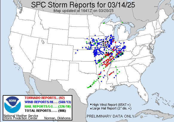
This really was a significant severe weather outbreak across many states, produced several significant tornadoes. So hopefully when all the surveys are done, I'll see if I can put together all the surveys from different states into one post eventually.
840
NOUS44 KHUN 172153
PNSHUN
ALZ001>010-016-TNZ076-096-097-181000-
Public Information Statement
National Weather Service Huntsville AL
453 PM CDT Mon Mar 17 2025
...NWS Damage Survey for 03/15/2025 Tornado Event...
.Lexington Tornado...
Rating: EF1
Estimated Peak Wind: 108 mph
Path Length /statute/: 2.29 miles
Path Width /maximum/: 63 yards
Fatalities: 0
Injuries: 0
Start Date: 03/15/2025
Start Time: 02:21 PM CDT
Start Location: 2 SW Lexington / Lauderdale County / AL
Start Lat/Lon: 34.9439 / -87.3985
End Date: 03/15/2025
End Time: 02:25 PM CDT
End Location: 1 SE Lexington / Lauderdale County / AL
End Lat/Lon: 34.9548 / -87.3609
Survey Summary:
The Lexington Tornado touched down on County Line Road 71 in a
field then tracked northeast. It hit an older two-car garage and
shifted it 2-3 inches from its foundation as well as damaged the
back half of the roof, but also snapped and uprooted a few large,
hardwood cedar trees. A small camper was also pushed into an
adjacent truck. The tornado continued northeast and downed and
uprooted numerous additional trees (both hardwood and softwood),
also damaging a fence. The tornado then uprooted and snapped more
trees, with these pointing in various directions, as it progressed
northeast. An outdoor, open-aired metal shed was demolished with
its contents strewn across the yard as well as debris scattered
across the residence and into the adjacent one. Across the street
were more downed trees, snapped limbs, and uprooted trees, with
another outdoor shed that had posts concreted into the ground,
collapsed. Trees caused roof damage to a home at this point and
damaged a vehicle next to it. As the tornado persisted, it
continued to snap trees and tree limbs, while uprooting numerous
other trees until it lifted just across County Road 51.
Lauderdale County EMA utilized their drone to discover that the
tornado started in the aforementioned field before it hit the two-
car garage and snapped the cedar trees. More downed trees were
also discovered via this drone footage around the midpoint of the
track. Special thanks to Lauderdale County EMA for their
assistance with this survey!
&&
EF Scale: The Enhanced Fujita Scale classifies tornadoes into the
following categories:
EF0.....65 to 85 mph
EF1.....86 to 110 mph
EF2.....111 to 135 mph
EF3.....136 to 165 mph
EF4.....166 to 200 mph
EF5.....>200 mph
NOTE:
The information in this statement is preliminary and subject to
change pending final review of the event and publication in
NWS Storm Data.
$$
Saari/Amiot
836
NOUS44 KBMX 200333
PNSBMX
ALZ011>015-017>050-201015-
Public Information Statement
National Weather Service Birmingham AL
1035 PM CDT Wed Mar 19 2025
...NWS Damage Survey for 03/15/2025 Tornado Event Update #8...
.Update...This update is to correct the end date for two
tornadoes.
Fourteen tornadoes have been confirmed across Central Alabama:
EF3: 1
EF2: 6
EF1: 4
EF0: 3
No further surveys are planned at this time; however, further work
is needed to finalize the Tuscaloosa County and Walker County
tornadoes. This will result in an increase in the total number of
tornadoes.
.Overview...Severe storms affected much of Central Alabama
Saturday afternoon and evening, including tornadoes, damaging
straight-line winds, and a few cases of flash flooding.
.Lewiston-Holman Tornado...
Rating: EF1
Estimated Peak Wind: 90 mph
Path Length /statute/: 26.26 miles
Path Width /maximum/: 1200 yards
Fatalities: 0
Injuries: 0
Start Date: 03/15/2025
Start Time: 03:08 PM CDT
Start Location: 2 SSE Pleasant Ridge / Greene County / AL
Start Lat/Lon: 32.9909 / -88.0707
End Date: 03/15/2025
End Time: 03:43 PM CDT
End Location: 3 NW Elrod / Tuscaloosa County / AL
End Lat/Lon: 33.3007 / -87.821
Survey Summary:
National Weather Service meteorologists surveyed damage
associated with a tornado in Greene, Pickens, and Tuscaloosa
Counties that began around 3:08 PM on March 15, 2025. The tornado
began on the south side of Highway 14 in Greene County, then
moved northeastward and crossed County Road 161 near Lewiston.
The tornado intensified as it approached County Road 60 where it
reached its maximum intensity of 90 miles per hour briefly.
Several trees were snapped with a few falling into an older
mobile home. The tornado then paralleled County Road
183 northeastward where several trees were seen uprooted or
snapped along or just east of the county road. The tornado
weakened as it crossed County Road 156 and the Pickens County
Line. It continued north-northeastward and re-intensified in a
wooded area east of Benvola Road. Numerous snapped trees were
observed along an unnamed dirt road. More trees were uprooted or
snapped along Lum Fife Road before the tornado eventually crossed
Highway 82 near Holman. Several trees were downed along Highway
82 near Minas Road before the tornado weakened on the north side
of Highway 82 in Tuscaloosa County and lifted along and just west
of Lee Bonner Road where a few more trees were uprooted.
.Gordo Tornado...
Rating: EF2
Estimated Peak Wind: 115 mph
Path Length /statute/: 21.53 miles
Path Width /maximum/: 950 yards
Fatalities: 0
Injuries: 0
Start Date: 03/15/2025
Start Time: 04:32 PM CDT
Start Location: 1 W Johnston Lake / Pickens County / AL
Start Lat/Lon: 33.1499 / -88.0569
End Date: 03/15/2025
End Time: 04:58 PM CDT
End Location: 3 SE Lubbub / Pickens County / AL
End Lat/Lon: 33.4013 / -87.8401
Survey Summary:
National Weather Service meteorologists surveyed damage
associated with a tornado in Pickens County that began around
4:32 PM on March 15, 2025. The tornado began in a wooded area
north of County Road 2, then moved northeastward across Houston
Windle Road near New Salem Missionary Baptist Church. The tornado
began to intensify as it moved northeastward, reaching EF-
1 strength as it crossed Ray Bass Road where numerous snapped
trees were observed. The tornado continued to intensify,
reaching EF-2 strength with maximum winds around 115 miles per
hour as it crossed Ebenezer Church Road. It likely maintained
this strength as it continued northeastward, crossing Hwy
86 where widespread tree damage was noted. As the tornado moved
into the Bostic Community, it destroyed several chicken houses on
Russell Farm Road. One residence on Russell Farm Road sustained
significant roof damage, and one manufactured home to the north
of Russell Farm Road was lifted and displaced. Auger anchoring
systems were pulled from the ground, and the home was severely
damaged, but the frame was largely intact. The tornado then
crossed Highway 82 on the west side of Gordo. A home sustained
substantial damage to the roof along Highway 159 near the
intersection of County Road 88. There were also numerous uprooted
and snapped trees observed around these locations. The then
tracked on the north side of County Road 88, destroying several
more chicken houses before weakening as it reached Fair Road
where another home sustained partial roof damage. The tornado
eventually lifted on the north side of Zion Road.
.Alamuchee Creek Tornado...
Rating: EF2
Estimated Peak Wind: 120 mph
Path Length /statute/: 3.32 miles
Path Width /maximum/: 650 yards
Fatalities: 0
Injuries: 0
Start Date: 03/15/2025
Start Time: 05:20 PM CDT
Start Location: 4 E Old Mallard Airport / Sumter County / AL
Start Lat/Lon: 32.4847 / -88.2078
End Date: 03/15/2025
End Time: 05:26 PM CDT
End Location: 4 NW Lilita / Sumter County / AL
End Lat/Lon: 32.5264 / -88.1798
Survey Summary:
The tornado began in a densely wooded area east of Loon Curl Rd
within a private hunting camp. It tracked northeast towards
County rd 13, crossing through and destroying several pine groves
along its path. In the area of most intense damage, a pine grove
featured hundreds of snapped trees in a width of roughly
500 yards. The EF2 rating was determined strictly from this area
of concentrated tree damage. The tornado began to weaken as it
crossed County road 13 just south of Alamuchee Creek where
multiple softwood trees were uprooted and a few were snapped. It
continued northeast where it then crossed a dirt road just east
of county road 13 where it produced sporadic tree damage. The
tornado dissipated shortly thereafter.
.Allenville Road Tornado...
Rating: EF0
Estimated Peak Wind: 80 mph
Path Length /statute/: 21.75 miles
Path Width /maximum/: 1300 yards
Fatalities: 0
Injuries: 0
Start Date: 03/15/2025
Start Time: 06:38 PM CDT
Start Location: 3 E Gallion / Hale County / AL
Start Lat/Lon: 32.4962 / -87.6689
End Date: 03/15/2025
End Time: 07:05 PM CDT
End Location: 2 S Morgan Springs / Perry County / AL
End Lat/Lon: 32.7189 / -87.4183
Survey Summary:
The tornado touched down just north of US Hwy 80 west of
Allenville Road, producing minor tree damage to numerous cedar
trees. The broad, weak but discernible tornado moved
northeastward crossing Allenville Road, CR 12, and AL Hwy
25 continuing to cause scattered tree damage. The tornado crossed
AL Hwy 61 north of Newbern, and began to turn more to the east.
It continued into Perry County, and as it crossed AL Hwy 14 it
produced the most significant tree damage of its path, with
numerous trees uprooted across the road. The last tree damage of
this tornado occurred on Morgan Springs Road, before it moved off
to the northeast and dissipated somewhere over Polecat Creek
before reaching Walter Boyles Road.
.Deer Creek Road Tornado...
Rating: EF0
Estimated Peak Wind: 80 mph
Path Length /statute/: 7.63 miles
Path Width /maximum/: 75 yards
Fatalities: 0
Injuries: 0
Start Date: 03/15/2025
Start Time: 07:39 PM CDT
Start Location: 2 NNE Talladega National Forest / Bibb County / AL
Start Lat/Lon: 32.9063 / -86.9776
End Date: 03/15/2025
End Time: 07:54 PM CDT
End Location: 2 SE Ashby / Bibb County / AL
End Lat/Lon: 32.9906 / -86.8946
Survey Summary:
National Weather Service meteorologists surveyed damage
associated with a tornado in Eastern Bibb County around 7:39 PM
on March 15, 2025. The tornado began on the north side of Highway
82 near the Maud Community. Trees were snapped along Deer Creek
Road before continuing northeastward and crossed Antioch Road,
County Road 171, and Highway 139. The tornado lifted East of Hwy
139 near the Oakley Community at around 7:54 PM. Maximum winds
were estimated to be around 80 miles per hour.
.Calera Tornado...
Rating: EF1
Estimated Peak Wind: 90 mph
Path Length /statute/: 7.28 miles
Path Width /maximum/: 250 yards
Fatalities: 0
Injuries: 0
Start Date: 03/15/2025
Start Time: 07:57 PM CDT
Start Location: 1 N Minooka Park / Chilton County / AL
Start Lat/Lon: 33.066 / -86.7608
End Date: 03/15/2025
End Time: 08:11 PM CDT
End Location: 2 ESE Shelby County Airport / Shelby County / AL
End Lat/Lon: 33.169 / -86.7535
Survey Summary:
The tornado began near the Chilton/Shelby County line in South
Calera and moved northward into downtown Calera, where mostly
tree damage was noted. There were several mobile homes damaged on
13th Street as the tornado paralleled Highway 31 before crossing
Interstate 65, where several campers at a dealership were rolled
and/or tossed. Numerous snapped trees were noted at this location
as well. The tornado made a left turn over Limestone Parkway and
moved north-northwest over a shopping center just east of the
intersection of US-31 and AL-70. Thereafter, the tornado moved
into the cone of silence of the KBMX RADAR near the O Neal
Quarry office, where many trees were snapped and uprooted. After
speaking with Lhoist quarry officials, no damage was reported at
the quarry, and the end of the tornado was placed just to the
north of Oak Tree Ln, where a few trees were downed. Maximum
winds were estimated to be around 90 miles per hour at both the
mobile home neighborhood and the camper dealership.
.Lawler Drive Tornado...
Rating: EF1
Estimated Peak Wind: 90 mph
Path Length /statute/: 2.55 miles
Path Width /maximum/: 150 yards
Fatalities: 0
Injuries: 0
Start Date: 03/15/2025
Start Time: 08:00 PM CDT
Start Location: 2 ESE Montevallo / Shelby County / AL
Start Lat/Lon: 33.0875 / -86.8291
End Date: 03/15/2025
End Time: 08:07 PM CDT
End Location: 1 SE American Village / Shelby County / AL
End Lat/Lon: 33.1225 / -86.817
Survey Summary:
National Weather Service meteorologists surveyed damage
associated with a tornado in Southern Shelby County around
8:00 PM on March 15, 2025. The tornado began near Highway 19 and
quickly intensified as it crossed Highway 25, reaching a maximum
intensity of 90 miles per hour as it crossed Lawler Drive. The
tornado continued northward eventually ending along Spring Creek
Road around 8:07 PM.
.Winterboro EF-2 Tornado...
Rating: EF2
Estimated Peak Wind: 120 mph
Path Length /statute/: 3.63 miles
Path Width /maximum/: 500 yards
Fatalities: 1
Injuries: 1
Start Date: 03/15/2025
Start Time: 08:42 PM CDT
Start Location: Winterboro / Talladega County / AL
Start Lat/Lon: 33.3194 / -86.2005
End Date: 03/15/2025
End Time: 08:49 PM CDT
End Location: 3 NNE Winterboro / Talladega County / AL
End Lat/Lon: 33.3603 / -86.1623
Survey Summary:
National Weather Service Meteorologists surveyed damage in the
town of Winterboro and just to the northeast and determined that
the damage was consistent with a tornado. The tornado touched
down just to the southwest of Winterboro High School, damaging
the football press box and surrounding baseball and softball
fields. The tornado quickly intensified as it reached the Old
Winterboro High School building, lifting a school bus onto the
side of the gymnasium. The gymnasium sustained significant
damage, with walls mostly collapsed on more than one side. Winds
were estimated to be around 120mph at this location, where wooden
power poles were also snapped. Debris from the collapsed
gymnasium was blown across State Highway 76 and the old school
building also sustained roof damage. The tornado continued to the
northeast, where numerous trees were snapped and uprooted and
homes sustained damage due to falling trees at the intersection
of Highway 76 and 21. As the tornado moved parallel to Bob White
Road, it maintained EF-2 intensity along the roadway and
destroyed a single-wide manufactured home. The debris from the
home was blown westward across Bob White Road. One fatality
occurred at this location. Outside of the peak intensity of the
tornado, some homes and farm outbuildings sustained roof damage
on the far eastern edge of the path on Bob White Road. The
tornado continued northeastward, weakening as it crossed Bullocks
Ferry Rd and finally lifting just to the northeast of Whiting Rd
and Lawler Cir. The tornado totaled 3.63 miles and had an
estimated width of 500 yards.
.Plantersville Tornado...
Rating: EF3
Estimated Peak Wind: 140 mph
Path Length /statute/: 24.33 miles
Path Width /maximum/: 1000 yards
Fatalities: 2
Injuries: 2
Start Date: 03/15/2025
Start Time: 08:50 PM CDT
Start Location: 1 NNW Valley Creek Junction / Dallas County / AL
Start Lat/Lon: 32.5978 / -86.9374
End Date: 03/15/2025
End Time: 09:20 PM CDT
End Location: 1 WSW Clanton / Chilton County / AL
End Lat/Lon: 32.8339 / -86.6501
Survey Summary:
The tornado formed and intensified quickly about 2 mile south of
Plantersville along County Road 63, uprooting swaths of trees
right from the start. The tornado traveled northward into
Plantersville and intensified to its maximum intensity of a
140 MPH EF3 tornado in the south end of town, where trees across
the entire area were uprooted, snapped, and even debarked.
Several homes and businesses were destroyed, which unfortunately
resulted in 2 fatalities and 2 injuries. The tornado began a
more northeasterly trajectory as it left Plantersville, but still
remained strong as it crossed into Autauga County. Entire swaths
of hardwood trees were uprooted and snapped, and estimates were
given the maximum rating possible for tree fall/tree snap at
134 MPH. Had there been other damage indicators impacted, it is
quite likely that portions in Autauga would also have been rated
at the EF3 level. The tornado continued northeastward into
Chilton County. As it approached County Road 64 it broadened out
and produced another area of maximum value tree snaps, where
acres and acres of pine trees were snapped at 10 to 20 feet above
the ground. It next crossed US Hwy 82, where 2 manufactured
homes had anchoring system failures and were vaulted and
completely destroyed, landing some 200 yards from their original
location. All the occupants were sheltered in a concrete shelter
and came through the storm physically unscathed. As the tornado
crossed Chilton CR 17, a well built brick home had its roof
completely removed with some exterior wall failure. Again, the
occupant had made the conscious decision to shelter elsewhere
with family members in a basement. EF2 level damage occurred as
the tornado crossed county roads 15 and 341. As the tornado
crossed CR 76, a well built home suffered damage when doors on
the main level were blown open, with the force of the breach
causing windows in an upper level bedroom to blow out. A double
wide manufactured home at the back of the property was vaulted
and destroyed. From here, the tornado took a more easterly
trajectory and began to gradually weaken, causing mainly tree
damage as it crossed south central Chilton County, before
dissipating in the West End portion of the city of Clanton.
.County Rd 29 Tornado...
Rating: EF1
Estimated Peak Wind: 110 mph
Path Length /statute/: 12.02 miles
Path Width /maximum/: 200 yards
Fatalities: 0
Injuries: 0
Start Date: 03/15/2025
Start Time: 09:33 PM CDT
Start Location: 2 NW Dollar / Coosa County / AL
Start Lat/Lon: 32.909 / -86.4495
End Date: 03/15/2025
End Time: 09:50 PM CDT
End Location: 3 ESE Weogufka / Coosa County / AL
End Lat/Lon: 32.9973 / -86.2715
Survey Summary:
National Weather Service Meteorologists surveyed damage in rural
southwestern Coosa County and determined that the damage was
consistent with a tornado. The tornado began over the Coosa
Wildlife Management area in extreme southwestern Coosa County,
just east of the Coosa River based on satellite imagery.
Unfortunately, that area of the county was not accessible by the
survey crew. The first area of damage that was accessible
occurred just southwest of County Rd 15, where numerous trees
were snapped and uprooted. The tornado continued northeast,
crossing CC Camp Rd where weak tree damage was noted. The tornado
intensified as it moved northeast and crossed County Rd 29. The
most extensive damage was found at this location, where numerous
trees were snapped and a double-wide manufactured home was
destroyed. No anchors were found where the manufactured home
originally stood. Farm outbuildings at the same residence were
also destroyed, along with roof damage to surrounding homes.
Winds were estimated at 110mph at this location. Although
difficult to access, EF-0 and EF-1 tree damage was noted farther
to the northeast along County Roads 56 and 18. With areas farther
northeast inaccessible and no damage noted along US Highway 231,
the end point was estimated just beyond County Rd 18.
.Horseshoe Bend Tornado ...
Rating: EF2
Estimated Peak Wind: 120 mph
Path Length /statute/: 20.44 miles
Path Width /maximum/: 800 yards
Fatalities: 0
Injuries: 0
Start Date: 03/15/2025
Start Time: 10:48 PM CDT
Start Location: 3 NNW Dare Park / Tallapoosa County / AL
Start Lat/Lon: 32.8695 / -85.8778
End Date: 03/15/2025
End Time: 11:12 PM CDT
End Location: 1 NNE Daviston / Tallapoosa County / AL
End Lat/Lon: 33.0711 / -85.6254
Survey Summary:
National Weather Service Meteorologists surveyed damage in
Tallapoosa County and determined that the damage was consistent
with a tornado. The tornado quickly touched down near Russell
Ferry Estates, crossing County Rd 40 and passing over Midway
Estates Rd. Extensive EF-0 tree damage was observed in this area.
Some trees fell on homes, where roof damage was sustained. As
the tornado crossed US Highway 280, minor damage occurred to some
metal buildings of businesses, and numerous trees were snapped or
uprooted. Farther to the northeast, extensive tree damage was
noted on Abbett Dr, with concentrated tree damage occurring on
Camp Ascca Rd. A manufactured home sustained roof and
underpinning damage close by, but remained anchored despite
witnesses mentioning that the home almost lifted off the ground.
Just 50 to 75 yards to the west of the home, extensive EF-2 tree
damage was observed. The tornado intensified as it almost
paralleled Rock Springs Road, where a single-wide manufactured
home was destroyed and debris blown 50 to 75 yards away. Winds
were estimated at 120mph at this location. The most extensive
tornado damage occurred on McBride Loop just off Rock Springs
Road, where countless numbers of large trees were snapped and
uprooted next to a small lake. In this same location, a single-
wide manufactured home was destroyed, with debris from the home
blown 50 to 75 yards to the northeast. Thankfully, the resident
of the home was not present and had decided to stay at a local
community storm shelter the night of the event. Winds were also
estimated at 120mph in this area. Notably, several other homes
located along McBride Loop were left mostly unscathed, and those
that did sustain damage were due to fallen trees. The tornado
continued northeastward at EF-2 intensity as it crossed over Rock
Springs Rd once again, then followed Horseshoe Bend Rd to the
Tallapoosa River. From there, the tornado moved across Horseshoe
Bend National Military Park. After contacting the Acting Park
Superintendent, valuable information and photos were provided
that indicated extensive EF-2 tree damage on the southwestern and
northeastern side of the park property. Near the battlefield
site, numerous trees were snapped and uprooted, extensively
blocking the Loop Tour Road and causing damage to outbuildings
and an exhibit pavilion. The tree damage on the northeast side of
the park property was very extensive, with countless trees
snapped. Where highest winds occurred, very few trees were left
standing. The tornado continued northeastward crossing County Rd
79 multiple times and moving through the Daviston Community with
EF-0 and EF-1 tree damage noted along the way. Finally, the
tornado moved along Motley Rd and Lil Beaver Rd before finally
lifting. No damage was found farther northeast along Cotney Rd.
The NWS would like to thank Tallapoosa County EMA and National
Park Service employees for their assistance in conducting this
survey and providing additional information.
.Pike County Tornado...
Rating: EF2
Estimated Peak Wind: 130 mph
Path Length /statute/: 21.29 miles
Path Width /maximum/: 1400 yards
Fatalities: 0
Injuries: 3
Start Date: 03/15/2025
Start Time: 11:02 PM CDT
Start Location: 2 SW Mossy Grove / Pike County / AL
Start Lat/Lon: 31.7383 / -85.9805
End Date: 03/15/2025
End Time: 11:28 PM CDT
End Location: 1 WSW Perote / Bullock County / AL
End Lat/Lon: 31.9491 / -85.723
Survey Summary:
The tornado first touched down on Pike County Road 2228 south of
Troy and west of AL Hwy 87 where a few branches were broken from
several trees in the area. It traveled northeastward crossing
Pike County Lake Road and then AL Hwy 87. As it approached Enzor
Rd, it caused significant roof damage to the Troy Parks and
Recreation building, as well as the softball fields at Troy
Sportsplex. The tornado began to strengthen to EF1 strength as
it approached US Hwy 231, causing significant tree damage with
numerous trees snapped or uprooted, as well as causing
significant damage to a service station canopy. It continued to
intensify and cause widespread tree damage as it moved up the
Walnut Creek. The tornado gained its maximum strength at 130 MPH
as it approached Elm Street Road, where one home received major
damage and was rendered uninhabitable. Several other homes
received indirect damage from tree fall in the area, where barely
a single tree was left standing. The tornado remained intense as
it crossed Butter and Egg Road, causing widespread tree damage.
The tornado veered slightly eastward and moved into banks, where
widespread tree damage continued, and a metal building received
significant damage as well. Continuing to the northeast, the
tornado began to gradually weaken in eastern Pike county,
primarily causing more sporadic, less intense tree damage, and
minor damage to structures. As the tornado crossed into southern
Bullock county, it continued to narrow and weaken until ending at
Bullock CR 8 west of Perote.
.Snapper Creek Tornado...
Rating: EF0
Estimated Peak Wind: 80 mph
Path Length /statute/: 3.80 miles
Path Width /maximum/: 100 yards
Fatalities: 0
Injuries: 0
Start Date: 03/15/2025
Start Time: 11:59 PM CDT
Start Location: 4 SSW Chambers County Lake / Chambers County / AL
Start Lat/Lon: 32.7831 / -85.381
End Date: 03/16/2025
End Time: 12:03 AM CDT
End Location: 1 S Kellys Crossroads / Chambers County / AL
End Lat/Lon: 32.8214 / -85.3355
Survey Summary:
The tornado touched down east of Chambers County Road 173 near
Snapper Creek in rural western Chambers County. The location is
based on radar analysis of a velocity couplet and developing
debris signature. The tornado crossed CR 73, where several pine
trees were uprooted. It continued northeastward crossing CR 174,
where a few pine trees were uprooted. The tornado weakened and
dissipated before reaching CR 83.
&&
EF Scale: The Enhanced Fujita Scale classifies tornadoes into the
following categories:
EF0.....65 to 85 mph
EF1.....86 to 110 mph
EF2.....111 to 135 mph
EF3.....136 to 165 mph
EF4.....166 to 200 mph
EF5.....>200 mph
NOTE:
The information in this statement is preliminary and subject to
change pending final review of the events and publication in
NWS Storm Data.
Public Information Statement
National Weather Service Nashville TN
121 PM CDT Sun Mar 16 2025
...NWS Damage Survey for March 15, 2025 Tornado Event Update #1...
On Saturday, March 15th, 2025, a line of showers and thunderstorms
moved through Middle TN. As the north-south line of storms crossed
over US Hwy 41A, it intensified causing a tornado to touch down
between US Hwy 41A and US 231. A couple hours later, a strong
mesocyclone moved out of Alabama and into Grundy county in southern
Middle TN. Strong straight line winds caused extensive damage in
Palmer, TN.
.EF-1/Christiana...
Rating: EF1
Estimated Peak Wind: 95 mph
Path Length /statute/: 4.49 miles
Path Width /maximum/: 300 yards
Fatalities: 0
Injuries: 0
Start Date: 03/15/2025
Start Time: 03:22 PM CDT
Start Location: 8 ESE Eagleville / Bedford County / TN
Start Lat/Lon: 35.6716 / -86.5328
End Date: 03/15/2025
End Time: 03:26 PM CDT
End Location: 9 NW Bell Buckle / Rutherford County / TN
End Lat/Lon: 35.6926 / -86.4573
Survey Summary:
The EF-1 tornado first touched down in far northwest Bedford
County near Carter Crossroads on Kingdom Road. At this location,
a half dozen outbuildings, storage buildings, and barns were
damaged or destroyed. The tornado continued east-northeast where
some minor damage occurred to homes along Longview Road. Garage
doors were blown in, fences were knocked down, outbuildings were
destroyed, and minor roof damage was observed. The tornado then
moved into far southwestern Rutherford County where trees were
downed on Threet Road as well as a few outbuildings damaged. More
tree damage was observed as the tornado approached Williams Road.
This area is no stranger to tornadoes as this tornado crossed the
path of the November 2018 Christiana tornado here. This path was
also just south of the May 2024 Christiana tornado as well. This
tornado crossed Midland Road and finally lifted near Jones Road
before reaching Highway 231.
.Grundy County/Palmer Straight Line Wind Damage...
After an exhaustive survey of the damage near Palmer in Grundy County,
a NWS survey team has determined the damage in this area to be caused
by straight line winds with max wind speed of 95 mph. The width of the
damage path was determined to be over a mile wide, ruling out a tornado.
These very strong downsloping microburst winds blew straight into
Palmer causing many trees to be uprooted and snapped, along with some
structural damage in the area. All trees were fell in the generally
the same direction with no narrow tornado path found.
Special thanks to Matt Griffith of Grundy County EMA for his
assistance with the storm damage survey.
&&
EF Scale: The Enhanced Fujita Scale classifies tornadoes into the
following categories:
EF0.....65 to 85 mph
EF1.....86 to 110 mph
EF2.....111 to 135 mph
EF3.....136 to 165 mph
EF4.....166 to 200 mph
EF5.....>200 mph
NOTE:
The information in this statement is preliminary and subject to
change pending final review of the event and publication in
NWS Storm Data.
$$
Unger
$$
099
NWUS54 KHUN 181451
LSRHUN
Preliminary Local Storm Report...Summary
National Weather Service Huntsville AL
951 AM CDT Tue Mar 18 2025
..TIME... ...EVENT... ...CITY LOCATION... ...LAT.LON...
..DATE... ....MAG.... ..COUNTY LOCATION..ST.. ...SOURCE....
..REMARKS..
0946 PM Non-Tstm Wnd Dmg 6 ESE Fayetteville 35.10N 86.47W
03/15/2025 Lincoln TN Emergency Mngr
Corrects previous non-tstm wnd dmg report
from 6 ESE Fayetteville. Tree fell onto
powerline and was on fire.
0944 PM Non-Tstm Wnd Dmg 6 SSE Moores Mill 34.77N 86.51W
03/15/2025 Madison AL Emergency Mngr
Report of powerlines down at 883 Old Gurley
Rd by EMA.
0940 PM Non-Tstm Wnd Dmg 5 NE Lynchburg 35.33N 86.29W
03/15/2025 Moore TN Emergency Mngr
Tree downed across the road.
0937 PM Flash Flood 6 N Harvest 34.94N 86.75W
03/15/2025 Madison AL Public
Social media report of water flowing over a
small bridge on Coogins Rd in Ardmore AL.
0936 PM Non-Tstm Wnd Dmg 2 NNE Harvest 34.88N 86.74W
03/15/2025 Madison AL Emergency Mngr
Tree down at HWY 53 and Berryland Rd
reported by EMA.
0936 PM Non-Tstm Wnd Dmg 1 SE Hazel Green 34.91N 86.56W
03/15/2025 Madison AL Emergency Mngr
Tree down at 460 Jimmy Fisk Rd reported by
EMA.
0936 PM Non-Tstm Wnd Dmg 4 NNE Skyline 34.86N 86.10W
03/15/2025 Jackson AL Emergency Mngr
Tree down on County Road 107 in Skyline AL
reported by EMA.
0935 PM Non-Tstm Wnd Dmg 2 NW Hazel Green 34.95N 86.60W
03/15/2025 Madison AL Emergency Mngr
Live powerlines downed in the 700 block of
Charity Lane in Madison County.
0932 PM Non-Tstm Wnd Dmg 4 S Fayetteville 35.09N 86.58W
03/15/2025 Lincoln TN Emergency Mngr
20 block of Melody Lane in Lincoln County,
fallen tree blocking roadway and power lines
downed.
0910 PM Non-Tstm Wnd Dmg 7 WNW Hazel Green 34.98N 86.67W
03/15/2025 Madison AL Emergency Mngr
Powerline downed at the intersection of
Elkwood Section Road and Terry Lane in
Madison County.
0910 PM Non-Tstm Wnd Dmg 4 SSW Moores Mill 34.79N 86.55W
03/15/2025 Madison AL Emergency Mngr
Tree on house in the 6000 block of Eastside
Lane, NE in Huntsville.
0800 PM Flash Flood 6 NNE Colony 34.02N 86.88W
03/15/2025 Cullman AL Emergency Mngr
Flash flooding caused a mudslide along
County Road 223 near Pewterfork Creek. Time
estimated.
0742 PM Flash Flood 3 SSE Tuscumbia 34.69N 87.69W
03/15/2025 Colbert AL Emergency Mngr
0733 PM Flash Flood 5 NW Littleville 34.65N 87.73W
03/15/2025 Colbert AL Emergency Mngr
0724 PM Flash Flood 2 ENE Sheffield 34.77N 87.68W
03/15/2025 Colbert AL Emergency Mngr
0700 PM Flash Flood 5 W Tuscumbia 34.72N 87.80W
03/15/2025 Colbert AL Emergency Mngr
0642 PM Tstm Wnd Dmg 6 NE Paint Rock 34.71N 86.24W
03/15/2025 Jackson AL Emergency Mngr
Report of a tree down at 6000 County Rd 8 in
Woodville AL from EMA.
0630 PM Flash Flood 8 E Rogersville 34.83N 87.15W
03/15/2025 Limestone AL Public
Social media report of a few inches of water
quickly flowing over Lentzville Rd in Elk
Estates.
0531 PM Funnel Cloud 5 E Cullman 34.18N 86.74W
03/15/2025 Cullman AL Public
0513 PM Tstm Wnd Dmg 2 NE Good Hope 34.13N 86.83W
03/15/2025 Cullman AL NWS Storm Survey
An NWS Storm Survey found an uprooted tree
SE of the intersection of CR 715 and CR 490
in Cullman County.
0457 PM Tstm Wnd Dmg 6 W Colony 33.95N 87.00W
03/15/2025 Cullman AL NWS Storm Survey
An NWS storm survey reported two snapped
trees south of AL Highway 69 S to the east
of Old Hambry Mill Rd in Cullman County.
0455 PM Tstm Wnd Dmg 5 SW Colony 33.90N 86.97W
03/15/2025 Cullman AL NWS Storm Survey
An NWS storm survey reported a snapped tree
SW of Arkadelphia in Cullman County.
0410 PM Tstm Wnd Dmg 1 NW Tuscumbia 34.74N 87.72W
03/15/2025 Colbert AL Emergency Mngr
Tree downed in the 100 block of Kentucky Ave
in Sheffield. Time estimated from radar.
0409 PM Flash Flood 3 NE Madison 34.74N 86.71W
03/15/2025 Madison AL Public
Report from mPING: Street/road flooding;
Street/road closed; Vehicles stranded.
0341 PM Flash Flood 4 NE Athens 34.82N 86.91W
03/15/2025 Limestone AL Public
Report from mPING: Street/road flooding;
Street/road closed; Vehicles stranded.
0317 PM Flash Flood 2 SSW Tuscumbia 34.70N 87.72W
03/15/2025 Colbert AL 911 Call Center
12 inches of water over Frankfort Rd.
0316 PM Flash Flood 4 NNE Killen 34.92N 87.50W
03/15/2025 Lauderdale AL Public
6 inches of water flowing over a portion of
CR 393.
0255 PM Flash Flood 1 SE Killen 34.85N 87.52W
03/15/2025 Lauderdale AL Emergency Mngr
Lingerlost Rd washed out near Chamberwell
Dr.
0255 PM Flash Flood 1 SE Killen 34.85N 87.52W
03/15/2025 Lauderdale AL Emergency Mngr
Part of Lingerlost Rd washed out near
Chamberwell Dr.
0247 PM Hail 4 E Killen 34.89N 87.47W
03/15/2025 E1.75 Inch Lauderdale AL Public
Report from mPING: Golf Ball (1.75 in.).
0245 PM Tstm Wnd Dmg 2 SE Lexington 34.95N 87.36W
03/15/2025 Lauderdale AL Public
Several trees down.
0245 PM Tstm Wnd Dmg 1 S Lexington 34.95N 87.37W
03/15/2025 Lauderdale AL Public
Several trees uprooted.
0245 PM Flash Flood 8 WSW Russellville 34.48N 87.87W
03/15/2025 Franklin AL Emergency Mngr
Deputy reported about a foot or more of
water on Hwy 524 hear Hwy 49 due west of
Russellville in the Belgreen community.
0239 PM Hail 3 WSW Killen 34.85N 87.58W
03/15/2025 E1.00 Inch Lauderdale AL Emergency Mngr
Emergency management reported quarter size
hail one mile west of Shoal Creek on Highway
72.
0236 PM Hail Tuscumbia 34.73N 87.70W
03/15/2025 M1.25 Inch Colbert AL Public
Half dollar hail reported in Tuscumbia.
0235 PM Hail Littleville 34.59N 87.67W
03/15/2025 M2.00 Inch Colbert AL Public
2.25 inch hail measured in Littleville.
0235 PM Hail 4 S Tuscumbia 34.67N 87.70W
03/15/2025 E1.50 Inch Colbert AL Public
Estimated ping pong ball sized hail.
0234 PM Hail 1 NNE Tuscumbia 34.74N 87.70W
03/15/2025 E1.25 Inch Colbert AL Public
Social media report received for 1.25 inch
hail.
0233 PM Flash Flood 10 N Hodges 34.47N 87.93W
03/15/2025 Franklin AL Emergency Mngr
Flash flooding reported on Old Nauvoo Road.
Depth of water estimated at 6 to 8 inches.
0230 PM Hail Killen 34.86N 87.53W
03/15/2025 E1.00 Inch Lauderdale AL Public
Estimated 1 inch hail was reported in
Killen.
0226 PM Hail 4 S Tuscumbia 34.66N 87.70W
03/15/2025 E2.75 Inch Colbert AL Emergency Mngr
Emergency Management reported baseball size
hail in the Colbert Heights community.
0220 PM Hail 8 WSW Russellville 34.48N 87.87W
03/15/2025 E2.00 Inch Franklin AL Public
Social media report received with photo of 2
inch hail.
0220 PM Tstm Wnd Dmg 1 NNW Tuscumbia 34.74N 87.71W
03/15/2025 Colbert AL 911 Call Center
Report of a tree down from 911 call center
at the corner S Blackwell Rd and W Wheeler
Ave.
0220 PM Tstm Wnd Dmg 2 NW Muscle Shoals 34.76N 87.66W
03/15/2025 Colbert AL Emergency Mngr
Tree downed near the Garage and Cherokee
Roads intersection. Time estimated from
radar.
0220 PM Tstm Wnd Dmg 1 NNE Sheffield 34.77N 87.70W
03/15/2025 Colbert AL Emergency Mngr
Tree downed in the 900 block of North
Montgomery Ave in Sheffield. Time estimated
by radar.
0217 PM Lightning 1 SSE Moulton 34.47N 87.28W
03/15/2025 Lawrence AL Broadcast Media
Apartment complex caught fire after a
lightning strike. No injuries reported.
0215 PM Tstm Wnd Dmg 1 NW Muscle Shoals 34.76N 87.66W
03/15/2025 Colbert AL 911 Call Center
Report of a tree down from 911 call center
at the corner of Gusmus Ave and Louise Ave.
0213 PM Hail 8 WNW Littleville 34.65N 87.79W
03/15/2025 M1.50 Inch Colbert AL Emergency Mngr
Emergency management reported ping pong ball
sized hail in New Bethel Alabama.
1000 AM Non-Tstm Wnd Dmg 5 S Killen 34.79N 87.53W
03/15/2025 Colbert AL 911 Call Center
Trees down on Cedar Lane and Old Covered
Bridge Road.
0945 AM Non-Tstm Wnd Dmg 5 S Killen 34.79N 87.53W
03/15/2025 Colbert AL 911 Call Center
Trees down in the 5000 block of River Road.
0850 AM Non-Tstm Wnd Dmg 4 NE Muscle Shoals 34.79N 87.60W
03/15/2025 Colbert AL 911 Call Center
Trees down in the 300 block of Ford Road.
0609 AM Flash Flood 2 SE Good Hope 34.09N 86.84W
03/15/2025 Cullman AL Emergency Mngr
Flash flooding reported in the 3400 block of
CR 616. Depth of water estimated at 6-8
inches.
0436 AM Hail 6 WSW Underwood-Petersv 34.84N 87.80W
03/15/2025 E0.50 Inch Lauderdale AL Public
Estimated 0.5 inch hail fell in Oakland.
0400 AM Lightning Russellville 34.51N 87.73W
03/15/2025 Franklin AL Emergency Mngr
*** 1 INJ ***
EMA reported a women struck by lightning in
Russellville AL around 4 AM Saturday
morning.
0315 AM Hail Hodges 34.33N 87.93W
03/15/2025 M1.00 Inch Franklin AL Emergency Mngr
&&
$$
504
NWUS54 KBMX 172240
LSRBMX
Preliminary Local Storm Report...Summary
National Weather Service Birmingham AL
540 PM CDT Mon Mar 17 2025
..TIME... ...EVENT... ...CITY LOCATION... ...LAT.LON...
..DATE... ....MAG.... ..COUNTY LOCATION..ST.. ...SOURCE....
..REMARKS..
0420 AM Hail 1 ENE Oakman 33.72N 87.37W
03/15/2025 E1.00 Inch Walker AL Public
Social media photo of quarter-size hail in
Oakman.
0431 PM Tstm Wnd Dmg 4 W Goodsprings 33.66N 87.32W
03/15/2025 Walker AL Broadcast Media
Trees down on Paul Bolton Road. Possible
tornado.
0431 PM Tstm Wnd Dmg 1 S The Wye 33.60N 87.37W
03/15/2025 Walker AL Broadcast Media
Trees down. Possible tornado.
0440 PM Tstm Wnd Dmg 3 ESE Parrish 33.72N 87.23W
03/15/2025 Walker AL 911 Call Center
Trees down. Reported by 911 center. Possible
tornado.
0450 PM Tornado Sipsey 33.83N 87.09W
03/15/2025 Walker AL Fire Dept/Rescue
Fire department responding to numerous
reports of trees down, including some on
houses, in Sipsey.
0452 PM Tornado 2 NE Sipsey 33.84N 87.05W
03/15/2025 Walker AL 911 Call Center
Several houses with significant damage, and
possible injuries, on Campbellville Road
northeast of Sipsey. TDS observed on radar
at the time.
0341 PM Tornado 3 NW Elrod 33.29N 87.83W
03/15/2025 Tuscaloosa AL Trained Spotter
Numerous trees snapped. A few trees
uprooted. At least one house with roof
damage. Spotter saw the tornado cross US-82
near Minas Road.
0402 PM Tstm Wnd Dmg 2 WNW Lake TCL Hwy 69 B 33.36N 87.58W
03/15/2025 Tuscaloosa AL Broadcast Media
Numerous reports of trees down around the
Samantha and Lake Tuscaloosa areas,
including Tierce Patton Road. Possible
tornado.
0402 PM Tstm Wnd Dmg 2 WNW Lake TCL Hwy 69 B 33.36N 87.58W
03/15/2025 Tuscaloosa AL Broadcast Media
Numerous reports of trees down around the
Samantha and Lake Tuscaloosa areas,
including Tierce Patton Road. Possible
tornado.
0404 PM Tstm Wnd Dmg 1 SW Binion Creek Landi 33.38N 87.62W
03/15/2025 Tuscaloosa AL Broadcast Media
Tree down blocking Highway 43.
0404 PM Tstm Wnd Dmg 1 SW Binion Creek Landi 33.38N 87.62W
03/15/2025 Tuscaloosa AL Broadcast Media
Tree down blocking Highway 43.
0410 PM Tstm Wnd Dmg 3 NNE Lake TCL Hwy 69 B 33.40N 87.52W
03/15/2025 Tuscaloosa AL Storm Chaser
Trees and power lines down on AL-69, between
Buffalo Ridge Road and Yellow Creek Road.
Lots of debris on the road. Possible
tornado.
0410 PM Tstm Wnd Dmg 3 NNE Lake TCL Hwy 69 B 33.40N 87.52W
03/15/2025 Tuscaloosa AL Storm Chaser
Trees and power lines down on AL-69, between
Buffalo Ridge Road and Yellow Creek Road.
Lots of debris on the road. Possible
tornado.
0423 PM Tstm Wnd Dmg 2 NNE Whitson 33.59N 87.39W
03/15/2025 Tuscaloosa AL Broadcast Media
Several large trees down on AL-69, just
south of the Tuscaloosa and Walker County
line. Possible tornado.
1048 PM Tornado 4 NNW Dare Park 32.87N 85.88W
03/15/2025 Tallapoosa AL NWS Storm Survey
An EF-2 tornado was confirmed in Tallapoosa
County.
1049 PM Tstm Wnd Dmg 3 WSW Jacksons` Gap 32.87N 85.87W
03/15/2025 Tallapoosa AL Public
Trees down involving a camper and shed.
Possible tornado.
1102 PM Tstm Wnd Dmg 1 NNE Horseshoe Bend NM 32.98N 85.74W
03/15/2025 Tallapoosa AL Public
Trees snapped and uprooted. Possible
tornado.
0832 PM Tstm Wnd Dmg 2 N Mignon 33.21N 86.27W
03/15/2025 Talladega AL Emergency Mngr
Trees blown down.
0833 PM Tstm Wnd Dmg Sylacauga 33.17N 86.25W
03/15/2025 Talladega AL Emergency Mngr
Trees down in the Sylacauga area.
0842 PM Tornado Winterboro 33.32N 86.20W
03/15/2025 Talladega AL NWS Storm Survey
*** 1 FATAL, 1 INJ ***
An EF-2 tornado was confirmed in the
Winterboro area of Talladega County.
0842 PM Tstm Wnd Dmg 1 SSW Winterboro 33.30N 86.20W
03/15/2025 Talladega AL Emergency Mngr
Tree on a house just off highway 21. No
injuries.
0843 PM Tstm Wnd Dmg Winterboro 33.32N 86.20W
03/15/2025 Talladega AL Fire Dept/Rescue
Damage reported at Winterboro High School.
0850 PM Tstm Wnd Dmg 3 NNE Alpine 33.40N 86.19W
03/15/2025 Talladega AL Emergency Mngr
Trees blown down.
0853 PM Tstm Wnd Dmg 2 ESE Talladega 33.42N 86.07W
03/15/2025 Talladega AL Emergency Mngr
Trees blown down on the southeast side of
Talladega.
0856 PM Tstm Wnd Dmg 2 ESE Talladega 33.42N 86.07W
03/15/2025 Talladega AL Emergency Mngr
Trees blown down in the vicinity of Highway
77 and Mountain View Road. Time estimated
from radar.
0900 PM Flash Flood Mignon 33.18N 86.26W
03/15/2025 Talladega AL Public
Water standing over roadways around Mignon
via Snapchat Map.
0528 PM Tstm Wnd Dmg 4 S Livingston 32.52N 88.19W
03/15/2025 Sumter AL Public
Seven to 10 large trees down, blocking CR-13
near the Alumuchee Creek bridge. Possible
tornado. Time estimated by radar.
0757 PM Tornado 2 N Minooka Park 33.07N 86.76W
03/15/2025 Shelby AL NWS Storm Survey
An EF-1 tornado was confirmed by NWS
meteorologists, affecting the Calera area.
0800 PM Tornado 2 ESE Montevallo 33.09N 86.83W
03/15/2025 Shelby AL NWS Storm Survey
An EF-1 tornado was confirmed by NWS
meteorologists, affecting areas between
Montevallo and Calera.
0802 PM Tstm Wnd Dmg Calera 33.11N 86.75W
03/15/2025 Shelby AL Public
Extensive damage to a trailer park in the
city of Calera. Possible tornado.
0819 PM Tornado 3 SE Shelby County Airp 33.15N 86.75W
03/15/2025 Shelby AL Emergency Mngr
Several reports of damage near the
I-65/US-31 intersection near Calera,
including businesses and homes.
0821 PM Tstm Wnd Dmg 1 WSW Indian Springs Vi 33.35N 86.77W
03/15/2025 Shelby AL NWS Employee
Several trees down in the Quail Run area.
0911 PM Flash Flood 3 N Calera 33.14N 86.75W
03/15/2025 Shelby AL 911 Call Center
Water over County Road 84 in Calera.
1206 AM Tstm Wnd Dmg 4 E Marvyn 32.44N 85.29W
03/16/2025 Russell AL Public
A home along Hwy 80 west of Crawford had
shingles and siding blown off and a few
bushes uprooted.
1215 AM Tstm Wnd Dmg 1 WSW Russell Co Sports 32.33N 85.17W
03/16/2025 Russell AL 911 Call Center
Trees reported down across various parts of
Russell county.
1049 PM Tstm Wnd Dmg 1 SE Fosters Crossroads 33.41N 85.55W
03/15/2025 Randolph AL Emergency Mngr
Numerous trees and a few power lines were
downed across the county, including the
Wadley, Wedowee, Roanoke areas and northern
Randolph, with a couple motor vehicle
accidents resulting from fallen trees.
1102 PM Tstm Wnd Dmg 1 NE Troy Sportsplex 31.78N 85.94W
03/15/2025 Pike AL Public
Damage along highway 231 involving downed
utility poles, busted out business signs,
downed trees. Probable tornado.
1111 PM Tstm Wnd Dmg 2 NW Banks 31.84N 85.87W
03/15/2025 Pike AL Storm Chaser
Downed trees. Damage to residences with one
MH rolled and destroyed. Probable tornado.
0347 AM Hail Gordo 33.32N 87.90W
03/15/2025 E1.50 Inch Pickens AL Public
Social media photos of half dollar to ping
pong ball size hail in Gordo.
0445 PM Tornado 1 NW Gordo 33.33N 87.92W
03/15/2025 Pickens AL Storm Chaser
Numerous trees snapped on US-82, near the
northwest city limits of Gordo.
1152 PM Tstm Wnd Dmg 3 N Sougahatchee Lake 32.71N 85.43W
03/15/2025 Lee AL Law Enforcement
Several trees down on Oak Bowery and Grand
National. Corrected for time based on radar.
1245 AM Tstm Wnd Dmg 3 N Sougahatchee Lake 32.71N 85.43W
03/16/2025 Lee AL Law Enforcement
Several trees down on Oak Bowery and Grand
National.
0639 PM Tornado 3 E Gallion 32.50N 87.67W
03/15/2025 Hale AL NWS Storm Survey
An EF-0 tornado was confirmed in Hale and
Perry counties.
0644 PM Tstm Wnd Dmg 2 N Laneville 32.55N 87.60W
03/15/2025 Hale AL Fire Dept/Rescue
Trees down on AL-25 and CR-57, in the
southern part of Hale County. Possible
tornado.
0652 PM Tstm Wnd Dmg 1 NNE Newbern 32.60N 87.53W
03/15/2025 Hale AL Fire Dept/Rescue
Trees down blocking the road on AL-61, and
near CR-16, both in and near Newbern.
Possible tornado.
0959 PM Tstm Wnd Dmg Deatsville 32.61N 86.40W
03/15/2025 Elmore AL Emergency Mngr
Trees down in the Deatsville area.
1115 PM Tstm Wnd Dmg 2 NNW Yates Dam 32.60N 85.91W
03/15/2025 Elmore AL Public
Reports of trees down across Upper River
Road in Tallassee.
0847 PM Tstm Wnd Dmg 2 WSW Valley Creek Junc 32.58N 86.97W
03/15/2025 Dallas AL Emergency Mngr
Trees down at CR 222 and HWY 22. TDS
appeared on the following scan.
0850 PM Tornado 1 N Valley Creek Juncti 32.60N 86.94W
03/15/2025 Dallas AL NWS Storm Survey
*** 2 FATAL, 2 INJ *** An EF-3 tornado was
confirmed in the Plantersville area of
Dallas County, continuing through Autauga
and Chilton counties.
0850 PM Tornado 1 N Valley Creek Juncti 32.60N 86.94W
03/15/2025 Dallas AL NWS Storm Survey
*** 2 FATAL, 2 INJ ***
An EF-3 tornado was confirmed in the
Plantersville area of Dallas County,
continuing through Autauga and Chilton
counties.
0853 PM Tstm Wnd Dmg 1 S Plantersville 32.64N 86.93W
03/15/2025 Dallas AL Emergency Mngr
Structural damage and trees down in the
vicinity of Lovelady Drive and CR 63. TDS
appeared on the following radar scan.
1000 PM Flash Flood 1 S Chalafinnee 33.53N 85.65W
03/15/2025 Cleburne AL Emergency Mngr
At least 5 roadways washed out in the Hollis
Crossorads area.
0902 PM Tornado 3 WNW Plecher 32.72N 86.84W
03/15/2025 Chilton AL Broadcast Media
Extensive damage reported reported on US-82
near Maplesville. TDS observed on radar.
0905 PM Tornado 3 NNW Plecher 32.75N 86.80W
03/15/2025 Chilton AL Broadcast Media
At least 2 houses and one manufactured home
received damage near the CR-15 and CR-16
area of Chilton County.
0922 PM Tstm Wnd Dmg Oxford 33.61N 85.84W
03/15/2025 Calhoun AL Emergency Mngr
Trees blown down in the Oxford area, at
least one onto a residence.
0928 PM Tstm Wnd Gst 1 ENE Anniston Regional 33.59N 85.85W
03/15/2025 M77 MPH Calhoun AL AWOS
AWOS station KANB measured a gust of 77 MPH.
1000 PM Flash Flood Oxford 33.61N 85.84W
03/15/2025 Calhoun AL Emergency Mngr
Instances of flooding in the Oxford area
with submerged vehicles, closed roadways,
and at least two water rescues.
0739 PM Tornado 2 NNE Talladega Nationa 32.91N 86.98W
03/15/2025 Bibb AL NWS Storm Survey
An EF-0 tornado was confirmed by NWS
meteorologists, affecting southeast Bibb
County near Thomas Mill.
0854 PM Tornado Plantersville 32.66N 86.92W
03/15/2025 Autauga AL Emergency Mngr
Extensive damage in Plantersville.
0957 PM Tstm Wnd Dmg 4 WSW Deatsville 32.58N 86.46W
03/15/2025 Autauga AL Emergency Mngr
Various reports of trees and powerlines down
across northeastern Autauga county.
&&
$$
Preliminary Local Storm Report...Summary
National Weather Service Nashville TN
710 PM CDT Sun Mar 16 2025
..TIME... ...EVENT... ...CITY LOCATION... ...LAT.LON...
..DATE... ....MAG.... ..COUNTY LOCATION..ST.. ...SOURCE....
..REMARKS..
1230 PM Flash Flood 3 E Waverly 36.09N 87.73W
03/15/2025 Humphreys TN Emergency Mngr
Some water over Highway 70 between Waverly
and McEwen. Road was still passable.
Otherwise, flooding of low lying areas near
creeks and streams reported.
1231 PM Flash Flood 1 S Goodlettsville 36.32N 86.70W
03/15/2025 Davidson TN Public
2 left lanes on I-65 NB just south of exit
95 are underwater. Report from social media.
0157 PM Flash Flood 3 NW Dickson 36.11N 87.42W
03/15/2025 Dickson TN Public
Videos on social media showing water over
Walnut Grove Road in Dickson county.
0244 PM Flash Flood Loretto 35.08N 87.44W
03/15/2025 Lawrence TN Emergency Mngr
Emergency Management reports US 43 is
flooded at Loretto.
0245 PM Flash Flood 1 N Lawrenceburg 35.26N 87.34W
03/15/2025 Lawrence TN Emergency Mngr
Emergency Manager reports street flooding in
Lawrenceburg, TN.
0259 PM Flash Flood 3 SE Portland 36.56N 86.48W
03/15/2025 Sumner TN Trained Spotter
The 1700 block of Old Gallatin Road SE of
Portland TN is blocked due to flood waters.
TSpotter.
0302 PM Flash Flood 3 S Lawrenceburg 35.20N 87.34W
03/15/2025 Lawrence TN Emergency Mngr
Rambler's Edge RV Park is flooded south of
Lawrenceburg TN.
0305 PM Flash Flood Portland 36.59N 86.52W
03/15/2025 Sumner TN Emergency Mngr
Old Gallatin Road in Portland is flooded.
0308 PM Tstm Wnd Dmg 3 SW Cornersville 35.33N 86.88W
03/15/2025 Marshall TN Public
Relayed via social media, photo of tree
snapped and power pole down on Blue Creek
Road.
0318 PM Tstm Wnd Dmg 6 SE Eagleville 35.68N 86.58W
03/15/2025 Bedford TN Trained Spotter
Possible structure damage near Kingdom road.
TSpotter.
0319 PM Tstm Wnd Dmg 2 NE Unionville 35.64N 86.57W
03/15/2025 Bedford TN Trained Spotter
Relayed from a TSpotter, damage to a
powerline and a tree at the intersection of
Longview Road and Pepper Hill.
0327 PM Flash Flood 2 NW White House 36.48N 86.69W
03/15/2025 Robertson TN Emergency Mngr
Neighborhood roads near Pinson Lane are
impassable.
0330 PM Tstm Wnd Dmg 7 SSW Murfreesboro 35.76N 86.43W
03/15/2025 Rutherford TN Public
Trees were blown down at Webb Rd and
Barfield-Crescent Rd. Time was estimated by
radar.
0330 PM Tstm Wnd Dmg 7 S Murfreesboro 35.75N 86.38W
03/15/2025 Rutherford TN Public
A privacy fence was blown down, partially
blocking road along Rucker Rd near County
Farm Rd.
0330 PM Tstm Wnd Gst 5 N Shelbyville 35.56N 86.44W
03/15/2025 M61 MPH Bedford TN AWOS
0345 PM Tstm Wnd Dmg 4 W Bradyville 35.74N 86.23W
03/15/2025 Rutherford TN Public
Trees were blown down and blocking the road
along Jacobs Hollow Rd near Bradyville Pike.
Time estimated by radar.
0355 PM Flash Flood 1 NW Westmoreland 36.57N 86.26W
03/15/2025 Sumner TN Emergency Mngr
Intersection of Hawkins Drive and Old
Highway 31 E flooded.
0355 PM Tstm Wnd Dmg 6 NE Unionville 35.68N 86.51W
03/15/2025 Bedford TN Public
Tree uprooted and damage to a metal building
was reported near Christiana.
0358 PM Tstm Wnd Dmg 8 NE Unionville 35.70N 86.49W
03/15/2025 Rutherford TN Fire Dept/Rescue
Rutherford County Fire working 2 reports of
large trees blocking roadways in Christiana.
6700blk Williams Rd, 4500blk Jones Rd.
0403 PM Tstm Wnd Dmg 7 NE Bell Buckle 35.67N 86.28W
03/15/2025 Rutherford TN Dept of Highways
Debris blocking I-24 east at mile marker
89.2 in Rutherford County. Tree across
roadway with all eastbound lanes blocked.
0415 PM Tstm Wnd Dmg 1 ESE Mcminnville 35.68N 85.77W
03/15/2025 Warren TN Public
Numerous downed trees were reported in the
McMinnville area. Time estimate from radar.
0500 PM Tstm Wnd Dmg Palmer 35.35N 85.57W
03/15/2025 Grundy TN Emergency Mngr
Trees down and structure damage to homes in
Palmer. Time estimated by radar.
0530 PM Tstm Wnd Dmg 1 E Jamestown 36.43N 84.92W
03/15/2025 Fentress TN Emergency Mngr
Several trees were blown down and minor
structure damage was reported on the north
side of Jamestown near Fairgrounds Rd.
0537 PM Flash Flood 1 ENE Cumberland Furnac 36.27N 87.35W
03/15/2025 Dickson TN Public
Portions of Stark Rd covered in water and
impassible in spots.
0537 PM Flash Flood 1 ENE Cumberland Furnac 36.27N 87.35W
03/15/2025 Dickson TN Public
Portions of Stark Rd covered in water and
impassible in spots.
0542 PM Flash Flood 2 S Cookeville 36.12N 85.51W
03/15/2025 Putnam TN Public
Water covering roads at South Jefferson and
Sliger Rd.
0543 PM Flash Flood 1 NNE Baxter 36.17N 85.63W
03/15/2025 Putnam TN Emergency Mngr
Water covering road at 1286 Main St. in
Baxter.
0549 PM Flash Flood 2 WSW Mount Pleasant 35.55N 87.22W
03/15/2025 Maury TN Public
Water was covering the road in several spots
along Highway 43 between Columbia and
Lawrenceburg.
0551 PM Flash Flood 1 ENE Berry Hill 36.12N 86.75W
03/15/2025 Davidson TN Public
Deep water covering the road at I-440 and
Nolensville Pike.
0613 PM Flash Flood 7 SSW Clarkrange 36.09N 85.06W
03/15/2025 Cumberland TN Public
Water flooding Highway 127N between
Crossville and Clarkrange.
0802 PM Flash Flood 3 N West Point 35.17N 87.54W
03/15/2025 Lawrence TN Emergency Mngr
Wisdom Rd near West Point completely washed
out.
1115 PM Flood Auburntown 35.95N 86.09W
03/15/2025 Cannon TN Trained Spotter
Hurricane Creek Rd. impassable due to
flooding.
1150 PM Non-Tstm Wnd Dmg Livingston 36.39N 85.32W
03/15/2025 Overton TN Emergency Mngr
Several trees down across the county due to
non thunderstorm winds.
1155 PM Non-Tstm Wnd Dmg 9 N Livingston 36.52N 85.32W
03/15/2025 Overton TN Public
Pictures from social media show a large
amount of roofing material blown off of a
church.
0119 AM Flood Cookeville 36.16N 85.51W
03/16/2025 Putnam TN Emergency Mngr
1343 Whiteaker Springs Rd. quickly becoming
covered in water.
0119 AM Flood Cookeville 36.16N 85.51W
03/16/2025 Putnam TN Emergency Mngr
1343 Whiteaker Springs Rd. quickly becoming
covered in water.
&&


No comments:
Post a Comment