


Here is a look at how it is shaking down as we get closer to the event, which starts Friday night around here. From about 9 PM Friday to 7 AM Saturday is a good estimate of when we'll see our severe weather. And it looks like at least some of it could be discrete supercells capable of producing tornadoes, large hail, and damaging winds.


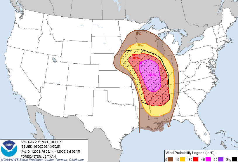
This looks like a pretty decent severe weather outbreak for several states, but let's focus in on local impacts. You can see that roughly along and West of I-65 is in the Level 3 Enhanced Risk for Friday. Areas to the East like Huntsville and Scottsboro, Guntersville are under the Basic or "Slight" Level 2 Risk of severe weather. And once you get over to Fort Payne, it's more of a Marginal Level 1 Risk.

The tornado risk is mainly what people care about, with good reason. So that 10% hatched area along and West of I-65 has the best chance of seeing supercells Friday night/early Saturday morning that produce significant tornado damage. So that cuts right through Cullman and includes places like Double Springs, Jasper, Haleyville, Russelville, the Shoals, Athens, Decatur, Hartselle. Then as you get over to Huntsville, Arab, Guntersville, they're outlooked for most of just a basic 5% risk for isolated tornadoes. And then Scottsboro, Rainsville, down to Gadsden, they have the marginal 2% tornado risk.
It's worth mentioning that while these basic guidelines usually help, they are not set in stone. Sometimes we get unlucky and the worst tornado of the night (or in some cases maybe the only tornado) happens in one of the lower-risk zones. But usually it happens in those hatched areas, or near there, the worst weather.


All of us are currently just outlooked for the basic 15% of large hail. But just from past experience with supercells, I'll throw in a note that sometimes they produce extra-large hail when they're not expected to, depends on how isolated they are and other factors. But this is coming through at night, the first round. So maybe that will mitigate the hail threat some, not during the daytime heating hours. Like you notice places in Mississippi do have a hatched area for very large hail, like golfball sized or larger. And they'll get the storms earlier in the afternoon/evening tomorrow. Meaning Friday.
The damaging wind potential is also significant, with hurricane-force winds in supercells possible from roughly around Madison/Huntsville to Fayetteville down to Cullman back through Jasper, Hamilton, points West of those areas in North AL and Southern/Middle TN. That's about a 30% chance of having those in those areas. The basic 15% risk of damaging winds (more likely to be about 60-70 miles per hour) in severe thunderstorms extends over to Scottsboro. And again if current trends hold, places like Rainsville or Fort Payne might only have a 5% marginal risk of damaging winds Friday night.
But I think everyone should take this severe weather threat seriously. Have a NOAA Weather Radio on alert with battery backup, or at least have WEA enabled on your cell phone so you have a source that will wake you up. And with a situation like this, you've got to do the right things. Do not stay in a mobile home during a Tornado Warning. Get into a site-built house or other sturdy building - small room (or hallway) on the lowest floor, near the center of structure, away from windows. And cover your body, especially your head, as best you can. Because some places could see significant damage from this, especially if a tornado touches down. If you're in or near a path of something like that, you'll want to be as safe as possible, including that extra layer of protection, like if debris falls or goes flying around, your head is protected in some way while that storm blows through. Something as simple as a window blowing out can become a big deal once in a while. And this is one of those nights you just want to dot all the i's and cross all the t's to be on the safe side. If you have a safety helmet, that is best.
SPC AC 130600
Day 2 Convective Outlook
NWS Storm Prediction Center Norman OK
0100 AM CDT Thu Mar 13 2025
Valid 141200Z - 151200Z
...THERE IS A MODERATE RISK OF SEVERE THUNDERSTORMS ACROSS EASTERN
MISSOURI...FAR SOUTHEAST IOWA...CENTRAL AND SOUTHERN ILLINOIS...FAR
WESTERN KENTUCKY...FAR NORTHWEST TENNESSEE...AND EXTREME NORTHEAST
ARKANSAS...
...SUMMARY...
A regional outbreak of severe storms is expected across much of the
Mississippi Valley, eastward to the Lower Ohio and Tennessee Valleys
late Friday afternoon into Saturday morning. Widespread damaging
winds (some greater than 65 kt), several tornadoes (some strong),
and large hail will all be possible.
...Synopsis...
An intense cyclone will develop from the central Plains to the Upper
Midwest on Friday. As this system rapidly deepens, an intense jet
streak (100+ kt at 500 mb) will overspread the Ozarks and Mid-MS
Valley. Meanwhile, a large area covering much of the MS Valley
vicinity will see 850-700 mb southwesterly flow around 65-80 kt.
Southerly low-level flow will transport mid 50s dewpoints as far
north as IA/northern IL (decreasing with northward extent across the
Upper Midwest). Richer boundary layer moisture (60s F dewpoints)
will be confined to the Lower MS Valley and Deep South/TN Valley,
though near-60 F dewpoints may reach the MS/OH River confluence.
Rapidly developing convection is expected to develop by late
afternoon from near a surface low over eastern NE and arcing
east/southeast along a dryline into the Ozarks. Convection will
develop northeast across the Mid-MS valley, with additional storms
develop with southward extent into the Mid-South and TN Valley
during the nighttime hours.
...Mid/Upper Mississippi Valley to the Lower OH/TN Valleys...
Cold temperatures aloft near the main upper low will support steep
midlevel lapse rates. While boundary moisture will be modest, MLCAPE
up to 1000-1500 J/kg is possible. This will support rapid storm
development amid intense deep-layer shear. Heating ahead of the
dryline also will support some boundary layer mixing and steepening
of low-level lapse rates. As a result, a rapidly developing QLCS is
expected. Convection will shift east/northeast into the nighttime
hours. Given fast storm motion and the intensity of deep-layer flow,
swaths of significant wind gusts (greater than 65 kt) are
anticipated over a large part of the Mid-MS Valley. A gradual
weakening of convection is expected after midnight with north and
east extent.
With southward extent from parts of eastern MO/western IL into the
Mid-South, some potential for a mix of linear convection and
supercells appears possible. Vertical shear will support tornadoes
within linear convection. The environment will especially be
favorable for strong tornadoes with any supercells that develop.
This activity may develop a little later than initial convection
further north, with much of the threat being after dark from
east-central MO/west-central IL southward to western TN.
Given the intensity of maximum gusts expected, and widespread
coverage of damaging gusts, a Moderate risk (level 4 of 5) has been
included for portions of the Mid-MS Valley vicinity.
...MS/AL/TN Overnight...
Persistent southerly low-level flow will bring mid to possibly upper
60s F dewpoints northward into the TN Valley overnight. Neutral to
modest height falls are expected and a persistent, strong low-level
jet will overspread the region. Forecast soundings indicate very
favorable thermodynamic and kinematic profiles, which would support
intense supercells. Forcing mechanisms will be somewhat modest over
the region, which may limit convective coverage, and a somewhat more
conditional risk. However, any storms that develop within this
environment overnight will pose a risk for strong tornadoes, large
hail and damaging gusts.
...Upper Midwest/Great Lakes vicinity...
The severe risk will become more marginal into MN/WI/MI. Strong deep
layer flow will overspread the region and any convection will pose a
risk of strong gusts. An additional risk for hail also will exist,
especially with any elevated convection near the warm front
overnight.
..Leitman.. 03/13/2025


No comments:
Post a Comment