FORECAST:
Saturday (High 70, Low 39): Sunny. Mild.
Sunday (High 76, Low 44): Mostly sunny and breezy during the day. Showers are likely at night, and where thunderstorms develop, they could be strong - or even reach severe limits.
Monday (High 68, Low 53): Mostly sunny. Cool.
EXTENDED OUTLOOK:
Tuesday (High 74, Low 41): Sunny.
Wednesday (High 67, Low 45): Sunny.
Thursday (High 70, Low 40): Sunny.
Friday (High 76, Low 45): Partly to mostly sunny.
PRONÓSTICO:
Sábado (Máxima 70, Mínima 39): Soleado. Templado.
Domingo (Máxima 76, Mínima 44): Mayormente soleado y ventoso durante el día. Probabilidad de lluvias por la noche, y donde se formen tormentas eléctricas, estas podrían ser fuertes o incluso alcanzar límites severos.
Lunes (Máxima 68, Mínima 53): Mayormente soleado. Fresco.
PRONÓSTICO EXTENDIDO:
Martes (Máxima 74, Mínima 41): Soleado.
Miércoles (Máxima 67, Mínima 45): Soleado.
Jueves (Máxima 70, Mínima 40): Soleado.
Viernes (Máxima 76, Mínima 45): Parcialmente a mayormente soleado.
NOTES:
There are still a few SKYWARN classes left this season.
Here are the latest tornado surveys from the March 15 event, at least the ones I compiled from around here.
DISCUSSION:
At 3 PM, the latest observations showing up for Cullman are from 2:35 PM CDT, but we can work with that. Skies are sunny. The temperature is 59 degrees.
Actually thanks to a conversation with a neighbor which distracted me, it is now 3:24 PM CDT and I can use the observations for 3 PM or technically 3:15 PM.
Skies are sunny, and the temperature is 61 degrees, or technically 60.8, but I round to the nearest whole number. The dewpoint is 21, or technically 21.2 degrees. So the relative humidity is 22%. Winds are out of the Southwest at 7 miles per hour with higher gusts up to 15 mph. The pressure is 30.08 inches and falling slowly. The Low this morning was 26.6, so we'll just call it at 27. Definitely a cold one, freeze warning was justified. And we could have another one before we get a week or two into April. No immediate signs of that, but it's just our local climatology. It can happen, some frosty mornings even after it's technically Spring already.


We've got high pressure in the Gulf, and it's been a refreshingly nice day in my opinion. And I definitely spent some time out on it today.
Looks like that basic pattern holds tomorrow and we'll see sunny skies, a High near 70, Low about 38-40 range.


Then Sunday also looks mostly sunny during the day. Looking for a High about 75-76, Low in the mid-40's.
But then Sunday night, rain is likely, and we could see enough instability for some thunderstorms.
But really that's looking more questionable as we get closer to the event. Even the NAM is showing barely any unstable air to work with at all.
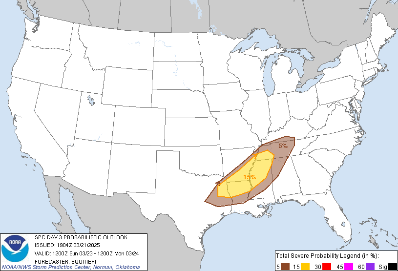

The Storm Prediction Center does still have a severe thunderstorm outlook for most of the TN Valley Sunday evening/night, but it is only a marginal 5% chance. And at this point, they've cut out about the Southeastern third of North Alabama. Places like Waynesboro might have a slightly better chance of some thunderstorms in the line reaching severe limits. As you get back into MS and the Ark-LA-Tex region, the threat for severe thunderstorms could get a little more organized.
This looks like a low-end threat for us, and really, if we don't get any more unstable air than the models are currently showing, it'll probably be another event like Wednesday night where we just get mainly rain without even much thunder, and gusty winds.
And a lot of people would take that over another event where we had at least 16 tornadoes in the same day. I think only storm chasers like those kinds of days, which even in the heart of our severe weather season, are relatively rare. But last Saturday was a doosie.

Then Monday looks mostly sunny with a High in the upper 60's, Low in the lower 50's. Could see isolated rain lingering in the morning behind the front, but I doubt even that.


Then high pressure moves back in, and we stay dry for the rest of the forecast period, it looks like.
Yesterday I made a mistake of putting in rain chances for Thursday, and I'm correcting it now. Had a lot on my mind lately. Some of those things have resolved for the better as of this afternoon. So hopefully the forecast improves accordingly.
Tuesday looks sunny with a High in the lower (maybe mid) 70's and Low of 40 or so. And it does look like we get a reinforcing cold front, but it's not Thursday, it'll be Tuesday night into Wednesday. Wednesday looks sunny with a High in the upper 60's again, Low in about the mid-40's. And then Thursday as the cooler air settles in more, at least good radiational cooling in the morning, we're actually looking at another sunny day with a High near 70, Low near 40.
So overall I'd say I'm the bearer of good news this time.
Just keep an eye on Sunday night. It's always good to have a weather radio on alert with battery backup just in case, or at least WEA on a cell phone. But the severe weather risk is really looking low, and I agree with the SPC issuing only the lowest threat level for us in case we have some damaging wind gusts or any storms that otherwise try to get out of hand.
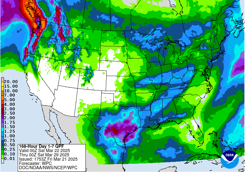
Rainfall totals will average up to about an inch. And we do still need that rain.
No comments:
Post a Comment