


So we'll see what happens now . . .

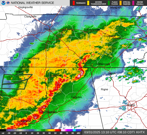
7:47 AM - And I fell asleep for a while. Looks like there were a few warnings that did not trip my weather radio. So here we are. The squall line is about to move through Cullman and is blanketed with Special Weather Statements for strong thunderstorms that are below severe limits.
Also got some flash flooding issues going on in Colbert, Franklin, and Lawrence Counties in NW AL.

7:59 - Winds could still gust up to 50 mph over the next 15 minutes or so as these storms finish blowing through.
Man, it has been a long time since I've fallen asleep at the switch. Perhaps in the near future, need to scale back the area I try to cover and conserve energy. Like forecast for the broad area but only post warnings for the areas that trip my weather radio. Which is usually Cullman, Walker, and Winston Counties. Now I think it's more like Cullman, Blount, Walker, and Etowah Counties since had to switch to Blountsville transmitter, or maybe it's in Oneonta, but same basic area. The Arab one would be great, but it doesn't pick up well from where I'm at. I doubt many (if any) people were following my blog at 5-6 AM or so, but . . . one never knows. And this doesn't happen often. Usually it takes me an hour or two after a system is through with the area to be able to fall asleep. This time it was like my body just used a shutoff safety valve and said "no more". I rested my eyes, and then it was a couple hours later with thunder rolling.

8:05 AM - Glad this squall line is no longer severe as it pushes through the local area though.
8:06 - Behind the line, the Severe Thunderstorm Watch is being cancelled out. And after it is, we won't have any more severe weather problems today. We may see another round Wednesday evening or night. And we'll have to watch Thursday too.
Tuesday looks really pleasant though.
Unfortunately the graphic I tried to post above of the watch being cleared out is several hours out of date. So that's a no-go.


.png)

.png)
.png)
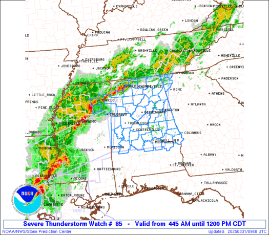
SEL5
URGENT - IMMEDIATE BROADCAST REQUESTED
Severe Thunderstorm Watch Number 85
NWS Storm Prediction Center Norman OK
445 AM CDT Mon Mar 31 2025
The NWS Storm Prediction Center has issued a
* Severe Thunderstorm Watch for portions of
Northern and Central Alabama
Far Northwest Georgia
Northeast Mississippi
* Effective this Monday morning from 445 AM until NOON CDT.
* Primary threats include...
Scattered damaging wind gusts to 70 mph likely
Isolated large hail events to 1.5 inches in diameter possible
A tornado or two possible
SUMMARY...Multiple lines and clusters of thunderstorms are expected
to spread eastward this morning across much of northern/central
Alabama and into far northwest Georgia. Scattered severe/damaging
winds should be the main threat with this activity, although
isolated hail and perhaps a tornado or two may also occur.
The severe thunderstorm watch area is approximately along and 75
statute miles east and west of a line from 25 miles northeast of
Huntsville AL to 20 miles south southwest of Selma AL. For a
complete depiction of the watch see the associated watch outline
update (WOUS64 KWNS WOU5).
PRECAUTIONARY/PREPAREDNESS ACTIONS...
REMEMBER...A Severe Thunderstorm Watch means conditions are
favorable for severe thunderstorms in and close to the watch area.
Persons in these areas should be on the lookout for threatening
weather conditions and listen for later statements and possible
warnings. Severe thunderstorms can and occasionally do produce
tornadoes.
&&
OTHER WATCH INFORMATION...CONTINUE...WW 81...WW 82...WW 83...WW
84...
AVIATION...A few severe thunderstorms with hail surface and aloft to
1.5 inches. Extreme turbulence and surface wind gusts to 60 knots. A
few cumulonimbi with maximum tops to 500. Mean storm motion vector
27035.
...Gleason


No comments:
Post a Comment