Plenty of lead time on this warning that includes Fayetteville, Huntland, and Winchester across Lincoln, Moore, and Franklin Counties. Winds could gust up to 60 miles per hour. The hail is expected to stay about penny-sized, which is below severe limits.
3:05 AM - Here's a good look at the polygon.
3:06 - Giles County has been removed from the warning because the storm is outta' there.
3:07 - The only other severe part of this squall line at the moment is that part moving into the Shoals with potential for hail up to the size of half dollars.
3:10 - Wayne, Lawrence, and Giles Counties have been cleared from the Tornado Watch as well as points North of there in Tennessee.
3:14 - Showing alternate radar sources can be a good strategy for staying awake at this hour . . .
3:23 - Things sure can vary within a squall line, different storms in it. This storm aiming at Winchester is racing along at 60 mph, while the one moving through the Shoals is slow-poking it at 35 mph. The Tennessee storm is warned mainly because of damaging wind gusts, the one in Northwest Alabama has a warning mainly because of severe hail up to the size of half dollars.
If I had to guess, within the next hour-and-a-half, when the Tornado Watch was originally set to expire, we'll probably see a Severe Thunderstorm Watch replacing it. And if that prediction is wrong, I'm just gonna' blame it on sleep deprivation.
3:30 - The warning for severe hail (estimated quarter-size now) has been extended into Lawrence County now.
That new warning polygon goes all the way from Muscle Shoals through Town Creek all the way down to Moulton. Moulton is on the Southern edge of this.
3:33 - The warning for Franklin, Lincoln, and Moore Counties in TN has been cancelled, as that part of the squall line has weakened below severe limits.
And really this one in NW AL is only severe because of the size of the hail, winds are expected to stay under severe limits.
3:49 - And now the warning in Northwest Alabama has been cancelled too. The storms are definitely in a weakening phase. The Tornado Watch continues for about another hour, until 5 AM CDT.
3:52 - Lincoln, Moore, and Franklin Counties have been cleared from the Tornado Watch. So the severe weather threat is over for all of our bordering Tennessee counties.
3:54 - We still have strong thunderstorms moving through Northwest Alabama, but they are under severe limits.
4:04 AM - And now we have an advisory for gusty winds in strong thunderstorms moving through mainly Jackson County in Northeast Alabama too.
4:20 - Some of these storms back in Central Mississippi bear watching.
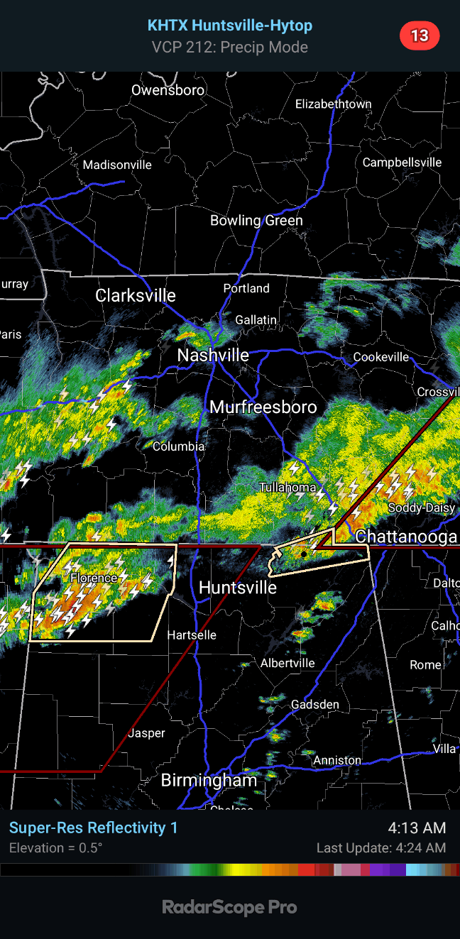
4:24 - But over on the Alabama side, we've got only a couple storms in the line, one in far Northwest AL, the other in far Northeast AL, that are pretty strong, but under severe limits. Tons of lightning in the one moving through the Shoals.
And we've got another half an hour on that Tornado Watch. We'll see if it's extended or if it's replaced by a Severe Thunderstorm Watch for certain places or what.
4:46 - Well my weather radio is going off for a new watch. So will post that soon. But for now, trained weather spotters have confirmed that these storms coming from Northwest Alabama are producing wind gusts up to 40 mph and nickel sized hail.
286
WUUS54 KHUN 310756
SVRHUN
TNC051-103-127-310845-
/O.NEW.KHUN.SV.W.0045.250331T0756Z-250331T0845Z/
BULLETIN - IMMEDIATE BROADCAST REQUESTED
Severe Thunderstorm Warning
National Weather Service Huntsville AL
256 AM CDT Mon Mar 31 2025
The National Weather Service in Huntsville Alabama has issued a
* Severe Thunderstorm Warning for...
Southeastern Moore County in Middle Tennessee...
Lincoln County in Middle Tennessee...
Franklin County in Middle Tennessee...
* Until 345 AM CDT.
* At 256 AM CDT, a severe thunderstorm was located 8 miles northeast
of Ardmore, or 12 miles west of Fayetteville, moving east at 60
mph.
HAZARD...60 mph wind gusts and penny size hail.
SOURCE...Radar indicated.
IMPACT...Expect damage to roofs, siding, and trees.
* Locations impacted include...
Huntland, Elora, Hurdlow, Maxwell, Mimosa, St. Andrews, Smithland,
Tims Ford Lake, Beans Creek, and Coldwater.
PRECAUTIONARY/PREPAREDNESS ACTIONS...
For your protection move to an interior room on the lowest floor of a
building.
A Tornado Watch remains in effect until 500 AM CDT for north central
Alabama...and Middle Tennessee.
&&
LAT...LON 3522 8586 3499 8586 3499 8683 3520 8683
3528 8591
TIME...MOT...LOC 0756Z 266DEG 52KT 3511 8678
HAIL THREAT...RADAR INDICATED
MAX HAIL SIZE...0.75 IN
WIND THREAT...RADAR INDICATED
MAX WIND GUST...60 MPH
$$
KDW


No comments:
Post a Comment