


Plenty of lead time on this. This warning is for damaging winds and large hail, but it's important to still take seriously and at least be inside, away from windows. If you can, get into a small central room or hallway on the lowest floor of a sturdy house while this blows through. This is well South of the cities of Cullman and Good Hope. But folks around Cold Springs, Brushy Pond, Bremen, Dodge City, over to the Colony. And actually Garden City is on the Eastern edge of this warning.
10:02 PM - Arkadelphia too, as the Spanish version of the polygon reminds me.
I have pursued this shot for over a year now. Tonight I am pleased to report, it has been achieved. @CamutoWHNT @DanielleDozier @spann @simpsonWVTM13 pic.twitter.com/0hEWOwlUAO
— James (@jameshannumWx) March 24, 2025
10:06 - Impressive lightning with some of these storms tonight too.

10:14 - Just got a new warning for Walker County that is for the storm coming out of Fayette/Marion Counties, includes Jasper again, but the polygon goes all the way down to Parrish.

10:17 - Here is the new polygon in detail.

10:22 - Now our only active warnings locally are for these storms moving through Walker and Southern Cullman Counties. The city of Jasper is included, the city of Cullman is not. The communities included in Cullman County are down around places like Bremen and Dodge City.

10:28 - Tennessee counties have been cleared from the Tornado Watch now. Northwest Alabama remains under a Severe Thunderstorm Watch.
10:30 - So a friend got me to step outside to enjoy the rain-cooled air. Then we had a lightning strike a little too close for comfort. The Salem cat seems a bit unnerved by the thunder. He was so smart last Saturday. I went looking to bring him into the shelter space, and the reason I couldn't find him all over the house was . . . he was already in there waiting on me. I'm a lucky guy.

10:32 - These storms continue to show signs of damaging wind gusts up to about 60 mph and hail up to about the size of quarters as they move through Walker and Southern Cullman Counties.

10:51 - The Cullman County warning has been allowed to expire. And we've got less than 10 minutes left on this warning for the storm just North of Jasper now.
344
WUUS54 KHUN 240257
SVRHUN
ALC043-240345-
/O.NEW.KHUN.SV.W.0041.250324T0257Z-250324T0345Z/
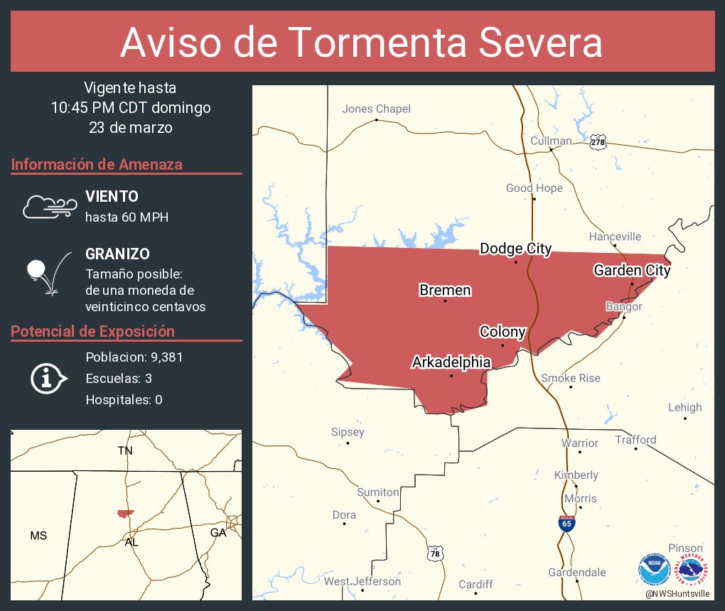
BULLETIN - IMMEDIATE BROADCAST REQUESTED
Severe Thunderstorm Warning
National Weather Service Huntsville AL
957 PM CDT Sun Mar 23 2025
The National Weather Service in Huntsville Alabama has issued a
* Severe Thunderstorm Warning for...
Southwestern Cullman County in north central Alabama...
* Until 1045 PM CDT.
* At 957 PM CDT, a severe thunderstorm was located near Curry, or
near Jasper, moving east at 40 mph.
HAZARD...60 mph wind gusts and quarter size hail.
SOURCE...Radar indicated.
IMPACT...Hail damage to vehicles is expected. Expect wind damage
to roofs, siding, and trees.
* Locations impacted include...
Wilburn, Bremen, Arkadelphia, Dodge City, Black Bottom, Colony,
Garden City, Smith Lake, and Hanceville.
PRECAUTIONARY/PREPAREDNESS ACTIONS...
For your protection move to an interior room on the lowest floor of a
building.
&&
LAT...LON 3389 8701 3390 8710 3392 8708 3399 8715
3399 8711 3406 8711 3405 8671 3404 8670
3395 8679 3396 8682 3393 8686 3394 8688
3392 8689 3391 8692 3387 8692 3386 8696
3386 8699
TIME...MOT...LOC 0257Z 281DEG 33KT 3393 8727
HAIL THREAT...RADAR INDICATED
MAX HAIL SIZE...1.00 IN
WIND THREAT...RADAR INDICATED
MAX WIND GUST...60 MPH
$$
RAD


No comments:
Post a Comment