


This is a dangerous storm passing through North Russellville.
6:25 PM - Moulton and Town Creek are also in this polygon. This is likely producing hail up to the size of lemons at this point.
The threat of a tornado developing in this storm is a borderline situation. I'd take shelter just from the damaging thunderstorm winds and extra-large hail. And then if a tornado were to develop (environment not especially favorable for that, and rotation usually staying broad on radar), you're covered.
Get into a small room or hallway on the lowest floor of a good sturdy, site-built house, away from any windows. And if you can, make that room near the center, instead of at the edge of the house. Put some walls between you and the outside. And cover your body in case of debris falling or flying around, especially protect your head and neck. If that's just with a pillow or some blankets, that's fine. It's best if you have some kind of a safety helmet like a bike helmet or batting helmet, football helmet, etc.
6:31 - WAFF 48 has a live stream going. I think the lady's name is Chelsea Aaron, but she's off camera for now. From what I remember, she's a good meteorologist. And I could do without the hype this evening. So switching to her for now.

6:40 - The northern of the two warnings was allowed to expire. This storm coming from Russellville toward, should pass between Town Creek and Moulton, is still showing signs of being able to produce hail up to the size of ping pong balls and 60 mph wind gusts. It has weakened some but is still a dangerous enough storm that I'd stay in a good safe place. Those earlier signs of even weak rotation have gone away though, and this storm is NOT trying to produce a tornado. So let's make the distinction.

6:50 - The warning for Lauderdale County has been reissued. And we've got more storms that look severe near Tupelo, soon to cross over the AL state line.
Any rotation that has shown up with these storms has come and gone, been pretty broad and/or weak. This is not an environment that particularly favors tornadoes.
The main threat is large hail, and damaging thunderstorm winds are also possible within any of these warning polygons.
7:02 PM - Kudos to Chelsea Aaron from WAFF-48 for not feeding the hype train tonight. We are having a few issues, but this is definitely a low-end event.

7:04 - These storms are mainly hailers, but some damaging wind gusts are also possible. It may sound like common sense, but definitely stay inside while these storms pass through - preferably inside a sturdy house away from windows or anything electrical.
7:07 - Tree down on Walnut Lane in Colbert County, also saw a video of some hail in Florence but couldn't tell how large it was.
Hail at Central Heights/Florence… video from Hillary DelaRosa pic.twitter.com/67UC1SOyRx
— James Spann (@spann) March 24, 2025
7:08 - Here is the hail video that James Spann passed along.

7:09 - And here's a close look at where our storms of concern are.
7:14 - The warning for Lawrence and Morgan Counties is being allowed to expire on time, because the storm has weakened below severe limits and is moving out of the warned area.

7:18 - But we do have a new warning for Marion County, that storm crossing over from Mississippi. This warning includes Hamilton and Haleyville and is for the possibility of half-dollar-sized hail and 60 mph wind gusts in this thunderstorm.
7:20 - And a warning continues for Lauderdale County, affects from Lexington down to Rogersville, for the next 10 minutes.
And I guess I'm finding this boring because I'm on WAAY-31's live stream now, bouncing around a lot this evening.
7:23 - Now that Lauderdale County storm has weakened below severe limits, so that warning will expire on time. Small hail, gusty winds, and a good bit of rain and lightning are still possible with the storm. But it's not though to be a serious threat to life or property beyond how all thunderstorms are. You know, most folks have enough sense not to stand out in lightning or hail. Or so you'd hope.

7:28 - These storms are really weakening a lot as they get close to I-65. The air is much stabler as you go further East. Which is why this original severe thunderstorm watch was only issued for mainly far Northwest Alabama. Wind gusts up to 30 mph is well under severe limits.


7:31 - So we just have this one warning for Northern Marion County that includes Hamilton and Hackleburg. Hail of about quarter-size and wind gusts up to 60 mph are possible here.


7:34 - On the other hand, trained spotters have confirmed a tornado moving East from Rolling Fork, MS, a town that was hit really hard a few years ago by a tornado. So we are fortunate to have a stabler airmass over here on the AL side with less favorable wind shear.
WUUS54 KHUN 232319
SVRHUN
ALC033-059-079-103-240015-
/O.NEW.KHUN.SV.W.0035.250323T2319Z-250324T0015Z/
BULLETIN - EAS ACTIVATION REQUESTED
Severe Thunderstorm Warning
National Weather Service Huntsville AL
619 PM CDT Sun Mar 23 2025
The National Weather Service in Huntsville Alabama has issued a
* Severe Thunderstorm Warning for...
Southeastern Colbert County in northwestern Alabama...
Northeastern Franklin County in northwestern Alabama...
West central Morgan County in north central Alabama...
Central Lawrence County in northwestern Alabama...
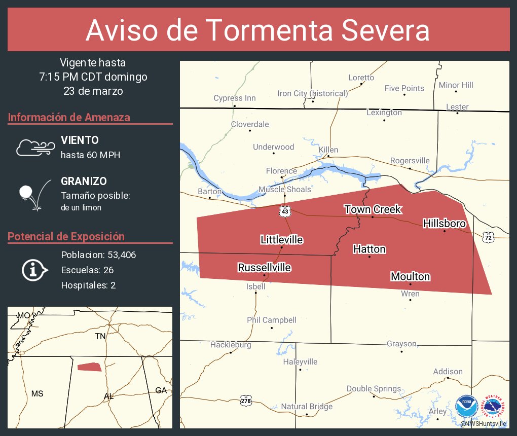
* Until 715 PM CDT.
* At 618 PM CDT, a severe thunderstorm was located near Littleville,
or near Russellville, moving east at 40 mph.
HAZARD...Two inch hail and 60 mph wind gusts.
SOURCE...Radar indicated.
IMPACT...People and animals outdoors will be injured. Expect hail
damage to roofs, siding, windows, and vehicles. Expect
wind damage to roofs, siding, and trees.
* Locations impacted include...
Posey Loop, Littleville, La Grange, Tharptown, Ne Smith,
Russellville, North Courtland, Hatton, Crooked Oak, and Red Bank.
PRECAUTIONARY/PREPAREDNESS ACTIONS...
For your protection move to an interior room on the lowest floor of a
building.
&&
LAT...LON 3468 8793 3478 8732 3475 8729 3476 8722
3472 8714 3445 8705 3450 8792
TIME...MOT...LOC 2318Z 268DEG 35KT 3458 8777
THUNDERSTORM DAMAGE THREAT...CONSIDERABLE
HAIL THREAT...RADAR INDICATED
MAX HAIL SIZE...2.00 IN
WIND THREAT...RADAR INDICATED
MAX WIND GUST...60 MPH
$$
RAD
No comments:
Post a Comment