


Main threat here is large hail, but a few damaging wind gusts are also possible. Especially if you have trees around your home, be mindful of that. And there is a lot of lightning in these storms of course.
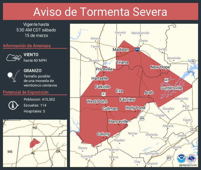
4:40 AM - All of Cullman County is included in this warning.

4:43 - And we'll have to watch this storm well West of Tupelo in Mississippi in case it were to hang together, showing signs of rotation, enough to prompt a tornado warning over there.
And I'm hearing hail hitting the roof now. Not going to go outside and see how big it is. That can wait until the storm is past . . . hah.

4:48 - Another severe thunderstorm about to move through Athens before heading up toward Moores Mill and New Market.
4:50 - Quarter-sized hail was confirmed in Oakman when the storms came through Walker County earlier. That was a public report from 4:20 AM, which some might say is an appropriate time for folks in Walker County to make storm reports. Ah well, just getting the jokes out of the way before the weather may get much more serious later today/tonight.

4:56 - Okay and now this is the only warning left in our area. The storm moving into Athens has weakened below severe limits, and that warning has been cancelled.
In the update to this Cullman County warning, the NWS Huntsville notes that there is an awful lot of cloud-to-ground lightning with this. And while that doesn't make a storm severe in and of itself, it's still dangerous. I know it's common sense, but please stay inside. It's not worth trying to go out and see the hailstones with this much lightning going on.
5:02 AM - Momentarily lost internet from these storms, but it's back now.

5:03 - Fayette and Lamar Counties have been cleared from the Tornado Watch.

5:07 - Some signs on radar of strong winds in Cullman County too, from Cullman to Good Hope to Hanceville to Colony, so remember damaging winds are possible here. The lightning is almost constant in the core of these storms. I think the hail was small, because the stuff that fell at my place was already melted when I glanced out on the porch. And frankly the lightning deterred me from glancing for very long.

5:15 AM - The Severe Thunderstorm Warning has been cancelled for Madison County, as storms have weakened up that way. The warning continues for Cullman, Marshall, and Eastern Morgan Counties. And now Northern Blount County has been added, all the way over to Snead. Damaging wind gusts and large hail will be possible.

5:18 - And I guess we'll hang in here until the Tornado Watch is cancelled this morning. But the main event is this afternoon and evening, could last into the night hours, as late as about Midnight. And it really could start at Midday, around Noon. But the worst time will likely be this afternoon and evening, with a high risk for supercell thunderstorms capable of producing tornadoes.

5:20 - The main focus for severe hail or damaging wind gusts now is for Hanceville, Holly Pond, Baileyton, Joppa, Arab, Union Grove, over to Guntersville. Also places like Blountsville, Oneonta, and Snead in Blount County, though they are not highlighted in this particular graphic. Blount County is covered by Birmingham, so the two polygons come out separately.
This is nothing compared to the major severe weather expected this afternoon and evening, but it is still wise to be in a good safe place, at least stay inside away from windows and electrical stuff, while these storms come through.
There is also a warning that affects Northwest Jefferson County to our South, places like Warrior.
But overall this morning round was "dicey", and the odds were in our favor this time. I frankly consider it a relief that we have not seen any tornadoes this morning in North Alabama or Southern Middle Tennessee. That supercell that prompted our Tornado Watch did produce a tornado in Mississippi, think it actually produced more than one as it moved across the state. But it's tough to verify that stuff at night, whether it was more than one tornado or several reports from a continuous tornado track. That could have happened here, but it didn't.
So as soon as these storms weaken, we can take a deep breath, enjoy the break in the action, and be prepared for the afternoon/evening round, which could get really bad.

5:29 - The severe thunderstorms are moving through Arab now.

5:31 - So we have a severe thunderstorm warning now from Blountsville to Susan Moore up to Snead, also Joppa, Arab, Guntersville, down to other parts of Marshall County like Albertville, Douglas, and Boaz.
This is a better visual showing how they've cancelled out another warning polygon behind all this.

5:45 - The only area of concern left with this morning round is Marshall County and a small part of Blount County around communities like Snead.

5:47 - Ok and now the Blount County part of the warning has been cancelled.
5:52 - For later today, people who need public shelters:
That is the main list.
Then for Central Alabama, this list looks good:
https://www.wbrc.com/page/storm-shelters-across-central-alabama/
Major thanks to Craig Ceecee for putting a national map together of public shelters:
https://findyourtornadoshelter.com/
Let me see if I can find something more for Middle TN though.
This article from WKRN-2 Nashville mainly refers people back to Craig's list I just linked to:
https://www.wkrn.com/news/local-news/tn-cities-with-public-tornado-shelters-map/
This list looks like it's for Eastern Tennessee into Northern Georgia mainly, but someone might find it useful:

6:01 AM - And we do have a new warning polygon that includes places like Eva up to New Hope, Gurley, Owens Crossroads, Paint Rock. And this is for the potential of damaging wind gusts or quarter-sized hail. The hail is more likely with this morning round, but especially if you have trees around your place, it is always wise to respect a Severe Thunderstorm Warning and take reasonable precautions against damaging wind gusts.

6:03 - This really is a marginal situation, and the storms in Marshall County have weakened to the point that the warning there has been cancelled.


6:07 - A new Tornado Watch has been issued for Northern MS back into LA. So things are just busy with this storm system overall.
6:11 - It looks like a lot of Tennessee counties were just cleared from the Tornado Watch. And we haven't had issues up there really, except that storm earlier near Savannah.
.gif)

6:18 - This is the only warning we have left from the morning round, severe thunderstorm warning mainly affecting Southeastern Madison County. There could be quarter-sized hail and wind gusts to about 60 mph in this cluster of storms. So it's worth respecting that risk. But there are no signs of it trying to produce a tornado. The tornado risk will come later today in the afternoon and evening, perhaps even the night hours as well. And the tornado risk is unfortunately expected to be significant then. This morning round was nothing compared to what we're probably in for later today/tonight.
.png)
6:22 - Only the counties highlighted in yellow remain under the Tornado Watch that was issued in the dark hours of this morning. They mainly issued that because of a long-track supercell that produced tornado damage across Mississippi. It weakened as it got over the Alabama state line, but we did have some storms showing signs of producing large hail and maybe some damaging wind gusts over the past few hours.
588
WUUS54 KHUN 150929
SVRHUN
ALC043-089-095-103-151030-
/O.NEW.KHUN.SV.W.0017.250315T0929Z-250315T1030Z/
BULLETIN - IMMEDIATE BROADCAST REQUESTED
Severe Thunderstorm Warning
National Weather Service Huntsville AL
429 AM CDT Sat Mar 15 2025
The National Weather Service in Huntsville Alabama has issued a
* Severe Thunderstorm Warning for...
Central Marshall County in northeastern Alabama...
Southern Madison County in north central Alabama...
Cullman County in north central Alabama...
Morgan County in north central Alabama...
* Until 530 AM CDT.
* At 429 AM CDT, a severe thunderstorm was located over Jasper,
moving northeast at 70 mph.
HAZARD...60 mph wind gusts and quarter size hail.
SOURCE...Radar indicated.
IMPACT...Hail damage to vehicles is expected. Expect wind damage
to roofs, siding, and trees.
* Locations impacted include...
Wilburn, Valhermoso Springs, Cullman, Crane Hill, Falkville,
Battleground, Lacon, Priceville, Hartselle, and Joppa.
PRECAUTIONARY/PREPAREDNESS ACTIONS...
For your protection move to an interior room on the lowest floor of a
building.
Torrential rainfall is occurring with this storm, and may lead to
flash flooding. Do not drive your vehicle through flooded roadways.
A Tornado Watch remains in effect until 1000 AM CDT for north central
and northwestern Alabama...and Middle Tennessee.
&&
LAT...LON 3386 8699 3389 8701 3390 8710 3391 8709
3399 8715 3399 8711 3430 8711 3458 8690
3455 8679 3472 8679 3481 8672 3441 8611
3439 8611 3421 8641 3426 8644 3425 8652
3412 8661 3408 8670 3405 8668 3403 8670
TIME...MOT...LOC 0929Z 219DEG 63KT 3386 8726
HAIL THREAT...RADAR INDICATED
MAX HAIL SIZE...1.00 IN
WIND THREAT...RADAR INDICATED
MAX WIND GUST...60 MPH
$$
KDW


No comments:
Post a Comment