

FORECAST:
Sunday (High 76, Low 42): Partly to mostly sunny and breezy during the day. Rain showers are likely in the evening and night hours, and where any thunderstorms form, they could become severe, the main threat being damaging wind gusts.
Monday (High 67, Low 51): Mostly sunny. Staying breezy and turning cooler.
Tuesday (High 75, Low 43): Sunny. Mild.
EXTENDED OUTLOOK:
Wednesday (High 69, Low 50): Mostly sunny.
Thursday (High 70, Low 41): Sunny.
Friday (High 77, Low 48): Mostly sunny.
Saturday (High 78, Low 56): Partly cloudy with a 20% chance of showers/thunderstorms.
PRONÓSTICO:
Domingo (Máxima 76, Mínima 42): Parcialmente a mayormente soleado y con brisa durante el día. Se esperan lluvias por la tarde y la noche, y donde se formen tormentas eléctricas, estas podrían volverse severas, siendo la principal amenaza las ráfagas de viento dañinas.
Lunes (Máxima 67, Mínima 51): Mayormente soleado. Permanecerá con brisa y se tornará más fresco.
Martes (Máxima 75, Mínima 43): Soleado. Templado.
PRONÓSTICO EXTENDIDO:
Miércoles (Máxima 69, Mínima 50): Mayormente soleado.
Jueves (Máxima 70, Mínima 41): Soleado.
Viernes (Máxima 77, Mínima 48): Mayormente soleado.
Sábado (Máxima 78, Mínima 56): Parcialmente nublado con un 20 % de probabilidad de lluvias/tormentas eléctricas.
NOTES:
While our severe thunderstorm risk tomorrow night is low, it's always good to make sure your severe weather safety plan is ready to go.
That was quite a severe weather event we had a week ago, last Saturday. The rain-cooled air helped North Alabama out a lot. We had a brief tornado in Leighton, but in Cullman County, only straight-line wind damage was found around Arkadelphia and a few places near there, trees snapped. The tornado that hit Sipsey in Walker County (rated E/F-2 but fortunately no injuries . . . sadly some tornadoes further to the South and also in some other states produced injuries and also some deaths) appears to have lifted just before it crossed the county line. Even though in real-time, there were some scary pictures showing up along with debris signatures on radar, as I recall. I was really surprised there was no damage up this way. People joke about that stuff and say, "We must be living right." But that's not how it really works. It can happen to anyone. James Spann's house got hit by a tornado a few years ago when he was warning other people of several similar storms. And Troy Kimmel from Texas had some serious storm damage a few years ago too, think his was from flooding. Also a National Weather Service employee out that way (who will remain nameless since he has set his social media to private these days . . . and frankly, I don't blame him . . . great forecaster and NWS dude though) recently had some minor damage to his home, can't remember if it was a tornado specifically or straight-line winds. I guess it's sort of like if you've ever been to the doctor during a bad flu season and notice he (or she) is sniffle-snorting just like everybody else. So we can feel grateful that we didn't get hit hard this time, but it was kind of a close call. And I think the people who took shelter (including me and some friends/neighbors) definitely did the right thing that day. Evidently folks down in Sipsey must have done the right things too, since nobody got hurt from that particular tornado. The one up in Leighton was short-lived but also produced no injuries. And that's kind of a good feeling to know that in the area I was watching, nobody got hurt from a pretty significant outbreak that affected so many states. But some folks to the South were not so fortunate, nor were a lot of people over in Mississippi or other states like Arkansas and Missouri. We were spared the worst this outbreak had to offer locally.
There are still some SKYWARN classes left to take this season. The next one is actually up in Rainsville this Thursday evening. And please remember that these classes are free. So anybody who finds it interesting is strongly encouraged to show up to one. They're doing a couple classes for the deaf and hard-of-hearing next month too, which I think is great.
And since the budget cuts are hurting many local offices around the country already, taking classes like this is a way we can all show them support during a difficult time. The National Weather Service is really something we cannot afford to lose. At some point over the past 50 years or so, it was originally called the Weather Bureau. But these people take their mission to protect life and property very seriously.
Yesterday was the anniversary of one of those rare tornado "superoutbreaks" that happened in 1932, before the Weather Bureau had become the National Weather Service and before we had really good outlooks, watches, and warnings for tornadoes or other serious storms. By the time the next one happened in 1974, things had improved some, but the Fujita/Pearson scale for rating tornadoes was only a few years old. And the people I know who lived through that mostly heard about the storms on the radio, by word of mouth, and by watching the sky. (My father remembers hearing J.B. Elliott on the radio that night, after his grandfather had said it wasn't going to do anything. When things started tearing loose, his grandpa changed his tone and said, "Boy, look at it sweepin' that countryside!" I knew him when I was a little kid, great guy, an eccentric, which makes me remember him more fondly.) We had a high death toll when we had the most recent one in 2011, but we did have excellent forecasts, Tornado Watches well in advance of the storms, and Tornado Warnings that gave people as much as 20 minutes to find a shelter in a lot of the worst storms. A lot of the tornadoes were shown on live video too, which is rare around here and certainly was not a luxury people had in 1974 or 1932. I hate to remember that event, because the vast majority of the people who died were within easy walking distance of a place they could have sheltered and survived. So there is still work to be done. But no sane person really wants to go back to the limited information people were able to collect and communicate about severe storms back in 1932. James Spann conducted an eerie interview with a man who survived the 1932 event even though the tornado (estimated to be at least F-4 strength . . . that scale didn't exist until the 1970's though) blew the whole house up around him and his family. Mike Wilhelm, a great storm chaser who is no longer with us, put that interview on YouTube.
This is not related to weather at all, but David Blaine did some great card magic on Kelly Clarkson's talk show the other day. And I thought it was really neat. Sometimes I like to share stuff that's more on the sunshine side of life.
And just a personal aside, yesterday I went to the library, had a backpack on my shoulder. The young lady working the desk said, "Can I help you?" And as I tried to get the backpack and take my books out, I dropped the whole thing right in the floor in front of me. I found the timing of that really funny. I was thinking: Well, I guess I do need some help here.
They have some decent books on weather and other science/math stuff there, by the way. I'm trying to learn the calculus I should have learned in college from one such book. But still refreshing myself on polynomials for now and just working through every chapter and getting it right. Slow and steady may win the race with such things. That particular book is excellent. And so are a lot of the other science books they've got, which are close to the math books on the shelves. I'd say their selection of weather books in particularly is not too shabby, but the really good ones, I've had to find for myself online, usually old used books sold at discount. Glad they've got the nonfiction section back these days. It was gone for a while after some storm damage a couple summers ago. And that was from straight-line winds, by the way, not a tornado.
Afterthought: Their weather book selection really is pretty good; I'm just persnickety. They have a couple books by Ginger Zee and James Spann in the mix, and it doesn't get much better than that. There are just a lot of books I would add to those shelves if it was up to me.
This "notes" section is sort of my way of remembering the NSSTC Collaborative Blog, an unfortunate casualty of Facebook taking over everything, but a great site while it lasted. I think Daniel Lamb was the main guy who wrote for it. I haven't even kept up with where he works now, but when he worked at the Huntsville office, and I saw him at Panoply, he said he was glad somebody out there was actually reading it. He and Dave Nadler were watching severe storms in (best I recall) Texas and Oklahoma on some monitors at their booth that day and saying they hoped a guy they knew out there still had a house.
DISCUSSION:


It was a sunny day in the Tennessee Valley with a Northerly breeze at times. The High in Cullman was 70, and the morning Low was 46. Huntsville saw a High of 69 and a Low of 45.
The nearest bunch of clouds are in Missouri for now, not enough rain showing up on the regional radar to even waste a graphic on this evening.


Basically we have another cold front coming through tomorrow night that'll bring rain, maybe a few storms, and then for the rest of next week, we clear out and return to sunshine and mild temperatures. So let's look at the details.


The day tomorrow should stay dry. It'll be quite breezy ahead of this front, with wind gusts up to 10-20 miles per hour or greater throughout the day. Look for a High near 75-76, a morning Low of about 42-43.


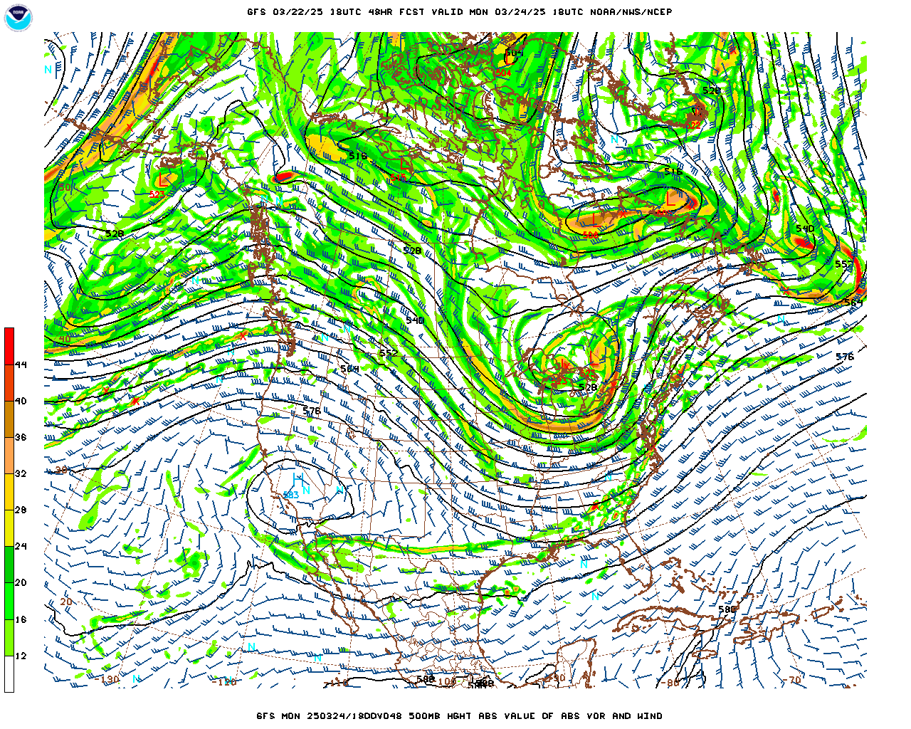
The NAM is showing a line of storms (squall line, or Quasi-Linear-Convective-System is the modern term - most people choose to just say QLCS - but I prefer "squall line") moving into Northwest Alabama some time between about sundown and Midnight. Technically the two times you see here (00Z and 06Z) are 7 PM CDT Saturday and 1 AM CDT Sunday. So in that time range is when we'll have some concern for some thunderstorms that could get strong or even reach severe limits.


The NAM is showing a decent combination of unstable air and wind shear over mainly far Northwest Alabama at about 10 PM, but then after Midnight going into Sunday morning, that combo appears to be falling apart.

Taking a forecast sounding from up around Red Bay or Vina at 10 PM, it shows really strong wind shear/helicity even at 1 kilometer. But there is almost no instability to work with, whether you look at surface CAPE values (well below 500 joules) or Lifted Indices only making it to about -2. And this is the part of our region where it looks like the best parameters are coming together.
So the most likely scenario for most of us is just a lot of rain, maybe not even all that much thunder and lightning in this line, and some gusty winds, similar to how things were Wednesday night. If the air can get unstable enough to support a few thunderstorms, they could easily become severe and produce some wind damage, at least to trees and power lines. But this severe thunderstorm risk looks really low this time. I know the computer is spitting out "tornado" in that graphic above, but that's a very conditional risk. When the wind shear (especially low-level helicity) is that strong, once in a while you can see a tornado even with instability that is below what's considered the baseline. But it isn't going to happen every time. The chance of a tornado in a setup like this is very low. And if you know how to read all the other parameters in that graphic above, even the Significant Tornado Parameter, you can see that the main threat here is just from damaging wind gusts.


The Storm Prediction Center has outlooked most of us around here for a Marginal Level 1 out of 5 Risk for severe thunderstorms tomorrow evening/overnight. Please note that this is the exact opposite end of the spectrum from the risk we dealt with last Saturday, when we had a High Level 5 out of 5 Risk. So if anybody was shaken up by a week ago, this is nothing to get overly worked up about. This is about as low as a severe thunderstorm threat gets while still being worth respecting. If you live in far Northwest Alabama where there is a Slight Level 2 out of 5 Risk, some of the more organized stuff might have a better chance of reaching you, but still, this is looking like a pretty low-end event. And sometimes we get through setups like this with no serious problems at all, just rain and gusty winds.
But per this SPC outlook, we have a 5% chance over most of the area for damaging wind gusts or severe hail (about quarter-sized). And there's about a 2% chance of an isolated tornado within 25 miles of any given point within this really broad area. So those technical details confirm what I've already said: This threat is really low with this system. It looks like we're going to have little to no unstable air to work with to support these updrafts that would want to rotate. Any severe thunderstorms that were able to develop would likely be short-lived in North Alabama/Southern Middle Tennessee.

Behind the front on Monday, we'll be mostly sunny, looks like rapid clearing with this one, will still be breezy, with winds turning back to the North as they usually do behind a cold front. Look for a High in about the range of 66-68 and a Low about 50-52.


Then Tuesday we'll be surrounded by nothing but high pressure and sunny, High in the mid-70's, Low in the lower 40's.


Then because of a reinforcing, but dry, cold front, Wednesday we'll see mostly sunny skies with a High near 70, Low near 50.


Thursday looks sunny with a High of about 70 again, the Low (due to the drier air behind the reinforcing front) closer to 40 again, maybe 41-42, but somewhere in that general range.


On Friday that high pressure moves off into the Atlantic, and we'll start to get some decent moisture return. But we should stay mostly sunny, just a few clouds coming back at this point, High making it into the upper 70's, the Low rebounding to the upper 40's, don't think most of us quite rebound to the 50-degree mark even though some of the National Blend of Models guidance shows that.


Then next Saturday, the GFS shows the next batch of rain staying just West of here, and the ECMWF (not shown here) is in good agreement. Will only reintroduce a 20% chance of rain just in case. It's a close call, but I wouldn't cancel any plans or anything based on what we're seeing right now. Look for a High in the upper 70's again and a Low in the 50's.
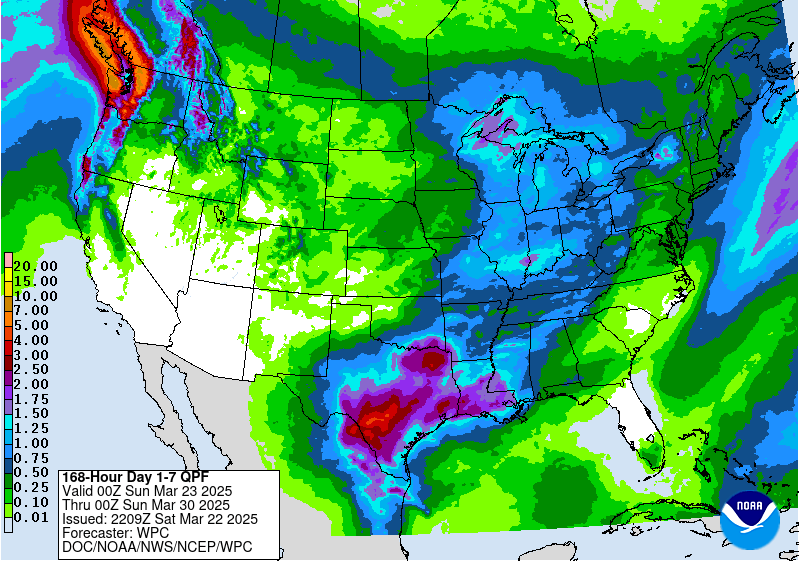
Rainfall totals will average between a half-inch and one inch for this forecast period.

And again, the risk for any thunderstorms becoming severe tomorrow night is very low. If you live up around the Shoals or places like Lawrenceburg, Waynesboro, down to Russellville and Hamilton, then things might get a little more organized for you, you're on the edge of that zone where more organized severe thunderstorms could track out of Mississippi. But overall our severe thunderstorm threat in the TN Valley is just barely enough to mention.
Having said that, I wouldn't want people to become complacent and totally disregard this. Especially since it's coming through at night. It's important to have your cell phone set to a mode where you can get Wireless Emergency Alerts that will wake you up if need be. And if you have a weather radio, that's even better, have it on alert with battery backup. And have a reasonable plan. It's better if you can shelter in a site-built house and not a mobile home, even if you "only" get a warning for damaging straight-line winds. And you want to get as low down in that structure as you can and kind of near the center of the house or building, away from any windows.
One important note is that WEA doesn't tone for a Severe Thunderstorm Warning unless it's tagged as a "Particularly Dangerous Situation". So really, weather radio is best. Or if you can afford a service like WeatherCall, that's a good investment for the long-term too. When I tell people to rely on WEA, it's only because I realize that a lot of people don't want to own a NOAA Weather Radio. Several family members and friends I know still don't have it, even the really smart folks. So it's one of those sad realities I've resigned myself to. Another reality is that most people have to either live in a mobile home or rent a place. If you live in a mobile home or a top-floor apartment (especially if you've got any trees around), then you need to make a friend who has a sturdier place or (in the case of the apartment) a place on a lower floor, preferably the ground floor. And that way you have somewhere to go on short notice in the middle of the night if the weather turns threatening. If you're in a mobile home and know somebody who would let you spend the night in a site-built house or an apartment (again, not up on a high top floor, since those can be vulnerable to winds too . . . not nearly as much as a mobile home, but still not the best place to be, just in case something were to happen like a window blowing out or a tree coming down), nights like tomorrow night are a good time to go give them some good company.
This severe weather threat is very low, but a few isolated spots in our region could see some problems. And any event seems significant if you do get hit directly, even if it's just a big tree limb coming down on your place. And I speak from experience there. A couple summers ago, I had a large limb bring a transformer down on where I live, nearly started a fire and knocked the power out for a while. And that wasn't even in our severe weather season. That day was a minor blip in the history of severe weather events around here, but you better believe I remember that day. So that's why I tell people, it's wise to be careful about this low-end events too. Don't let them worry you, per se, but have a reasonable plan and a reliable way to get warnings, especially when it's overnight like this, and something needs to wake you up.
Another idea is to leave a radio station playing that cuts in for severe weather. If they use that really abrasive emergency alert tone (like I know for sure the classical NPR stations do - 90.3 FM out of Birmingham and also 89.3 FM out of Huntsville), that is about as hard to sleep through as the sound of a dog barfing. So you'll know what's going on.
And in the long term, if you're reading this, please invest in a weather radio. They tend to last ten years or more, even if you've had crazy cats like I have knocking them in the floor and stepping on the buttons a lot. I've had the same one for more than 15 years now, and it works great even though the top of the antenna is broken off, and in other ways it has obviously seen better days. They don't even make the exact design I have anymore. So it's a wonderful long-term investment. And if you don't want to hear it all that often, you can use the SAME code programming so that it only alerts for your county and none of the others around you.
We definitely need the rain, but in case a few of us were to get "more than that", stay safe tomorrow night. And here's wishing you a pleasant week beyond. See you in the funny papers.


No comments:
Post a Comment