

FORECAST:
Monday (High 65, Low 44): Isolated showers may linger in the early morning, otherwise mostly sunny. Cool and breezy at times.
Tuesday (High 72, Low 37): Sunny. Cold in the morning, mild in the afternoon.
Wednesday (High 74, Low 41): Mostly sunny. Mild.
EXTENDED OUTLOOK:
Thursday (High 71, Low 52): Partly to mostly cloudy with a 40% chance of showers/thunderstorms.
Friday (High 76, Low 54): Partly cloudy.
Saturday (High 73, Low 61): Thunderstorms likely - possibly severe.
Sunday (High 66, Low 48): Sunny.
PRONÓSTICO:
Lunes (Máxima 65, Mínima 44): Lluvias aisladas pueden persistir temprano en la mañana, por lo demás mayormente soleado. Fresco y ventilado a veces.
Martes (Máxima 72, Mínima 37): Soleado. Frío en la mañana, templado en la tarde.
Miércoles (Máxima 74, Mínima 41): Mayormente soleado. Templado.
PERSPECTIVA EXTENDIDA:
Jueves (Máxima 71, Mínima 52): Parcialmente a mayormente nublado con un 40% de probabilidad de lluvias/tormentas eléctricas.
Viernes (Máxima 76, Mínima 54): Parcialmente nublado.
Sábado (Máxima 73, Mínima 61): Tormentas eléctricas probables, posiblemente severas.
Domingo (Máxima 66, Mínima 48): Soleado.
DISCUSSION:
Then taking a quick peek at our neighbors to the North, Huntsville saw a High of 60 and a Low of 41 today. And Nashville, where they saw more just clouds instead of rain, saw a High of 64 and a Low of 42.


Only a couple of severe weather reports today, some trees and power lines reported down in Drake Acres in Gadsden County, Florida near Lake Talquin. And there was a report of half-dollar-sized hail in West Lincoln, Mississippi.


The upper-air balloon soundings from 7 AM this morning (since we are now on Daylight Savings Time, bleh) from both Birmingham and Nashville show an airmass far too cool and stable to support severe thunderstorms anywhere up this way. There was some decent wind shear, especially in Birmingham, but you really need all the ingredients to come together just right. This is our primary severe weather season, but this was only expected to be a cool rain up in North Alabama/Southern Middle Tennessee, and that's all we got. And the rain stayed pretty light this far North of the frontal boundary.
Sadly I continue to see news stories of a few sites suspending some of their radiosonde balloon launches because of such sudden government budget cuts. That may not seem like that big a deal, but it really is. Because we already could use more sites like that.

These are all the sites in the country. And we really rely on these a lot to have information about all levels of the atmosphere, not just what is happening down at the surface. This helps human forecasters forecast severe weather (including stuff like winter storms . . . there are many details they can pick up on, like whether freezing rain is likely to be an issue, by looking at temperature changes with height) and also is part of the data we feed every day to the numerical models that forecast the future state of that atmosphere. We can tend to take those models for granted these days, but you know, they were operating under a handicap back in 2020 when flights were cancelled, and we weren't getting data from aircraft like usual. And if radiosonde launches continue to be suspended, even at a few sites, that is going to diminish the accuracy of our weather forecasts overall. It definitely will on the computerized side. Maybe it's the time for that human element in weather forecasting to stand up stronger. But morale tends to get low when people are worried about their job security. Fortunately our Congressman Robert Aderholt seems to take this issue seriously. And maybe some others will in time. But these are not what you'd call peaceful, encouraging times for meteorologists. Some of them took an incentive package and picked a mighty fine time to retire from a long career in the National Weather Service.


The rain will be tapering off tonight into early tomorrow morning. We could see a stray shower left over tomorrow morning (early) but overall will see a mostly sunny day, High near 65, Low tonight/in the morning near 44. Winds should stay from the North/Northeast and generally be settling down, but at times, we could still see some gusts up to about 10-15 miles per hour.
Tuesday will be sunny with a High in about the 70-73 range, Low in about 36-39 range. Our winds will turn back around the West and then Southwest and stay light.
Wednesday looks to stay mostly sunny with a High in the lower-to-mid-70's and a Low in the lower 40's.

Then we'll deal with a weak system on Thursday that will bring about a 30-40% chance of rain, which means it stays kind of scattered. High should be about 70, Low of 50 or so.

Friday is one of those in-between-systems days. Looks like partly cloudy skies, a High in the mid-70's an a Low in the lower 50's. Of course we'll be watching that powerful storm system and 984 millibar Low pressure system over the Northern Plains. Notice it's got quite a bit of snow on the back side of it, storms out ahead of it.

The Storm Prediction Center has outlooked a large chunk of the Midwest, Ohio Valley, Mid-South, and even a small part of the Tennessee Valley (Northwest Alabama, Western Tennessee) for a risk of organized severe weather on Friday/Friday night.

And that trailing cold front moves in here on Saturday. Thunderstorms are likely, and some may be severe. High temperature should be about in the lower 70's, the Low near 60.


The GFS is showing a secondary Low pressure system in a favorable position to support severe weather around here. And it's shown this on several runs over a few days now. Showing 1 PM through 7 PM here so you can see the track of that secondary Low. That may be the thorn in our side around here. The main Low is going to be way up around the Dakotas and Great Lakes.
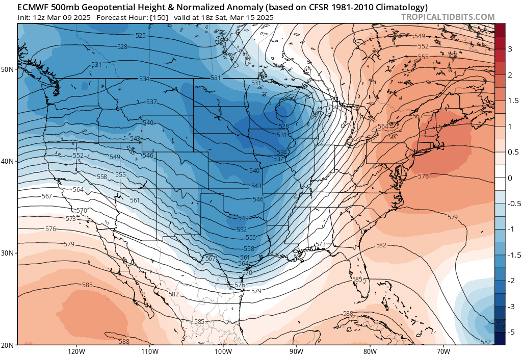

Now the European model (ECMWF) is still not picking up on this. And now that the event is six days out, we do have to take that into account too. This could make a big difference in how significant our severe weather threat is around here. And as a general rule, the European model tends to do better at this time range with these things.
But I am getting concerned by this trend the American model (GFS) keeps showing. We've certainly seen things like this happen before.
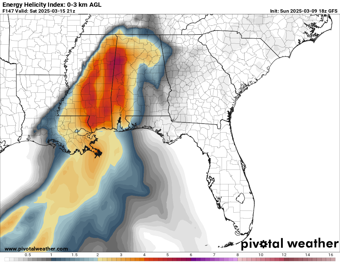
At 4 PM Saturday the GFS shows a really concerning combination of unstable air and wind shear, especially over West Alabama but really for most of our area. Things look a little more concerning on the Alabama side of the line versus the Tennessee side, but remember now, this is six days away. And some combination of instability/wind shear is already showing up further to the North into Tennessee.

Looking at a forecast sounding at that time, we have moderately unstable air combined with really strong wind shear, including the kind of low-level wind shear we'd look for to produce tornadoes, when the atmosphere has that fuel (unstable air) to tap into that wind shear. Notice the curved hodograph in the upper right. And even if you don't remember the specific parameters like helicity or bulk shear in numbers, you can look at those wind barbs going up the left-hand box and see the winds turning and wind speed changing as you go farther up in the atmosphere.
Frankly, this is beginning to look concerning. With the last two events, we had weak or virtually no instability to go with really strong wind shear. This time, it looks like we'll get moderately unstable air to tap into wind shear values that are higher than I'd prefer to see them this early in the severe weather season. This will support a threat for damaging winds, large hail, and tornadoes in the region. We're still six days away, but it's time to let everyone know to take this seriously and see how things are trending as the event gets closer. This has the potential to be a significant severe weather event for at least some of us in this neck of the woods.

Taking a forecast sounding from about the vicinity of Hamilton, Alabama (Marion County, near MS state line), things look even more concerning, where the parameters specifically point to a threat for particularly damaging tornadoes as you get into that part of the region where the instability is stronger and again, appears likely to combine with some really strong wind shear.
These details still need to be fine-tuned over the next few days, but this could be a severe weather outbreak for some people. And at least part of the Tennessee Valley could fall into that zone that will be at risk for significant damage from severe thunderstorms and/or tornadoes.

At this point, SPC outlooks all of our area in North Alabama/Southern Middle Tennessee (and frankly the entire state of Alabama, you can't help but notice) for a basic 15% risk of severe weather. In the coming days, it is likely that part of this area will have to be upgraded to the enhanced 30% risk, probably the Western counties. And then once it gets within 2-3 days of the event, they start doing more detailed outlooks.
But everybody needs to take this one seriously. We could have some issues with significant damaging winds, large hail, and tornadoes with this one, beyond what we had in the mid-February or early March events. This looks like an organized risk for all modes of severe weather, where at least some of us could see damage that is significant. That is a very real possibility somewhere within this broad area you see outlooked. And like I say, my opinion for now is that near the MS/AL state line may be the hot spot for supercell thunderstorms to form and the worst problems to get going. We need to be vigilant about this one. It could turn into one of those fairly significant events. Even if not, the threat for severe thunderstorms and tornadoes looks organized enough that it's definitely worth taking seriously.

Then behind the front, we'll be sunny again on Sunday with a High in the 60's, Low in the 40's.

Rainfall totals are expected to average 2-3 inches over the next seven days, and we will have to watch for the threat of flash flooding with Saturday's event along with the threat for severe thunderstorms capable of producing tornadoes.
Wish I had better news about the weekend's weather, but it is definitely the time to review your severe weather safety plan while the weather is still nice. All the injuries I noticed in the last two severe weather events happened in mobile homes. And people living in them especially need a plan to get to a safer place well ahead of any storm that may be producing a tornado.
Most of this week's weather looks a lot more comfortable than we'd have in a while though. So if you want to look at the half of the glass that's full . . . hope you enjoy the week. Just be prepared for this weekend, because we will have some threat for severe weather, whether it ends up being more routine or a more significant event. Right now I'm leaning toward the latter unfortunately, but it's still six days away and is just something to watch very carefully.


No comments:
Post a Comment