

FORECAST:
Tuesday (High 73, Low 38): Sunny. Light winds from the Southwest.
Wednesday (High 76, Low 43): Mostly sunny. Southerly breeze gusting up to 10-15 miles per hour at times.
Thursday (High 72, Low 53): Rain showers likely. Isolated thunderstorms are also possible.
EXTENDED OUTLOOK:
Friday (High 78, Low 55): Partly cloudy.
Saturday (High 75, Low 61): Thunderstorms likely - possibly severe.
Sunday (High 68, Low 50): Mostly sunny.
Monday (High 69, Low 39): Sunny.
PRONÓSTICO:
Martes (Máxima 73, Mínima 38): Soleado. Vientos leves del suroeste.
Miércoles (Máxima 76, Mínima 43): Mayormente soleado. Brisa del sur con ráfagas de hasta 10-15 millas por hora en ocasiones.
Jueves (Máxima 72, Mínima 53): Probables lluvias. También son posibles tormentas eléctricas aisladas.
PERSPECTIVA EXTENDIDA:
Viernes (Máxima 78, Mínima 55): Parcialmente nublado.
Sábado (Máxima 75, Mínima 61): Probables tormentas eléctricas, posiblemente severas.
Domingo (Máxima 68, Mínima 50): Mayormente soleado.
Lunes (Máxima 69, Mínima 39): Soleado.
NOTES:
There is a SKYWARN class tomorrow evening at 6 PM in Tuscumbia. The National Weather Service in Huntsville has scheduled a few other classes through April now as well. There are still some classes being offered (mostly online) by the Birmingham and Nashville offices too. Actually it looks like Nashville only has the advanced class left, which is good for people who already have learned the basics of storm spotting.
Those are the best places to review your severe weather safety, but here is a post I made about tornado precautions if you'd rather read through that.
Jeff Evans from the National Weather Service in Houston, Texas has retired, much like John Gordon recently did from Louisville.
The American Meteorological Society has posted a statement about how essential NOAA/NWS is even during times of government budget cuts.
Just for fun, FOX-35 in Orlando got hit by a tornado today while covering the severe weather in Florida. Everybody was okay. Which is why it's fun to watch.
We have a total lunar eclipse/"blood moon" coming up the night of Thursday March 13 into the morning of Friday March 14 this week.


At 9 PM, skies are clear in Cullman. The temperature is 50 degrees. The dewpoint is 25, making the relative humidity 37%. Winds are calm, though it was a breezy day overall with winds generally out of the North. The pressure is 29.93 inches and rising. The High today was 68 after a morning Low of 48.
Skies are clear in Huntsville with a temperature of 57 degrees. The dewpoint is 24, making the relative humidity 28%. Winds are from the Northwest at 3 miles per hour. The pressure is 29.91 inches/1012.6 millibars and rising. The High was 70, and the Low was 44.
And Nashville has clear skies and 54 degrees tonight. The dewpoint is 27, making the relative humidity 35%. Winds are South at 6 mph. The pressure is 29.91 inches/1012.7 millibars and rising. Saw a High a High of 69 and Low of 37 there.
The cold front has moved into the Atlantic, and that upper Low is along the Carolina coast. We have a High pressure system centered just off the coast of Texas that is influencing our weather now.


The Skew-T's of the upper-air radiosonde launches from Birmingham and Nashville at 7 PM this evening showed some nice, stable air and winds dying down from what they were over the past day or two.


Tomorrow we've got High pressure centered in the Gulf, and we'll have sunny skies, a High near 73 and Low near 38. Winds should stay light, and you can see up at 500 millibars/~18,000 feet they're from the West, so at the surface they're probably going to be more Southwest.


The High pressure will shift to the East/Southeast on Wednesday, and we'll stay mostly sunny with a High of about 75, Low about 43-44. Winds will start to pick up against, with gusts up to 10-15 mph possible, especially in the evening.


It is now looking like rain showers are likely Thursday, and some could start even in the morning, maybe when it's still dark. We'll have enough unstable air to support isolated thunderstorms, but it's mostly just going to be rain. Look for a High near 70, Low in the lower 50's.


It's the extended period that has everybody's attention. Above is an overview of it. Now let's take it day by day.


Friday we've got that deep Low pressure system over the Northern Plains.

And this has the potential to be a severe weather outbreak affecting the Midwest and Mid-South. Some counties in Northwest Alabama and places in Tennessee like Lawrenceburg, Waynesboro, and points West may see some severe thunderstorms that night or early the next morning, maybe when it's still dark. They are included in the basic 15% risk from SPC. All modes of severe weather will be possible here - large hail, damaging winds, and tornadoes. And there are likely to be supercell thunderstorms in addition to a squall line affecting this broad area.
Around here, for the most part we just stay partly cloudy during the day Friday with a High in the upper 70's, look for a Low in the lower 50's.


The GFS has sped up the timing of the rain/storms ahead of this cold front so that it's well into our area by 1 PM Saturday on this latest run.

But please note the track of this secondary surface Low remains favorable for severe weather around here. Even though the main Low is way up around the Great Lakes.


The GFS is showing a decent combination of instability and wind shear even by 7 AM Saturday.

And taking a forecast sounding then for near Double Springs, it is showing some moderately unstable air and pretty strong wind shear, including more than 200 m^s/^2 of Storm Relative Helicity down at the lowest 1 kilometer of the atmosphere. This look would support severe thunderstorms capable of damaging winds, large hail, and isolated tornadoes.

Looks like there will be some risk of severe weather throughout the day, so multiple rounds possible, but things ramp up again around 4 PM according to this guidance.

And at that point, along the Walker/Winston county line, the GFS is showing strong instability (over 2,000 joules/kilogram of CAPE - surface-based fuel for storms. It's showing ample wind shear with Storm Relative Helicity over 250 m^2/s^2 up at 3 kilometers and roughly around 150 units for the lowest kilometers. With these ingredients and a cold front coming in, you can have a tornado threat as well as a threat for large hail (could be very large, like golfball or larger for some people when you get a setup like this) and damaging winds in thunderstorms. So if this verifies, the tornado threat may be a little enhanced for Saturday afternoon/evening, seeing a Significant Tornado Parameter of 2.

.png)
.png)
Sort of an odd setup according to the ECMWF, showing some supercells in the morning and midday hours, then by evening (7 PM) all that forming into a squall line, or it actually looks like maybe more than one line. This looks like a messy day as far as storm mode, where from morning through afternoon, could see supercells, clusters, and then by evening, at least one line of storms. It wouldn't be the first time we've ever seen that. I can remember other times we had supercells in the morning. But usually you think of them more in the afternoon/evening hours.

.png)
.png)
And even in the morning, dewpoints are forecast to be up in the 60's. So this looks plausible. Looks like a stormy day.

The Storm Prediction Center has upgraded much of North, Central, and even South Alabama to an enhanced 30% risk for severe weather for Saturday's event. This also includes parts of Eastern and Southern Mississippi. This is the most likely corridor in which supercell thunderstorms are likely to develop and track from Southwest to Northeast. Those storms will have the best chance of producing a tornado as well as large hail and damaging thunderstorm winds.
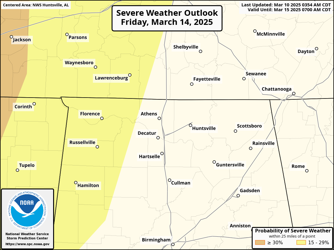

So from late Friday night through all day Saturday (possibly even lasting into Saturday night), we all have a risk for severe weather in the Tennessee Valley. Maybe it ends up being a more organized/significant threat on the Alabama side, especially along and South of the TN River. But everybody in North Alabama and Southern Middle Tennessee needs to be aware that this region could have severe thunderstorms out of this - capable of large hail, damaging winds, and a few tornadoes across the map.
Have a good safety plan and reliable ways to get warnings. Don't just rely on an outdoor siren, especially since some of this could start in the early morning, before people wake up. Those outdoor sirens were never meant to wake people up indoors like a NOAA Weather Radio does, or cell phone alerts can.

Rainfall totals for the next seven days will average about 2.5-3 inches. And of course, severe thunderstorms, especially supercells, can dump a lot of rain really quick, which can pose a risk for localized flash flooding sometimes too.
And here at the bottom, I realize I got carried away analyzing the severe weather potential. Basic forecast for Saturday is thunderstorms likely, possibly severe, look for a High in the lower-to-mid-70's, Low near 60. Then sunshine returns behind the front on Sunday and Monday, Highs in the upper 60's and the Low Sunday morning near 50, near 40 Monday morning.


No comments:
Post a Comment