

FORECAST:
Friday (High 62, Low 28): Sunny. Frost is likely in the morning.
Saturday (High 70, Low 39): Mostly sunny. Cold in the morning, mild in the afternoon.
Sunday (High 75, Low 46): Partly cloudy and breezy during the day. Thunderstorms are likely at night, and a few may become severe.
EXTENDED OUTLOOK:
Monday (High 66, Low 51): Mostly sunny with a 20% chance of lingering showers.
Tuesday (High 70, Low 40): Sunny.
Wednesday (High 71, Low 44): Sunny.
Thursday (High 72, Low 47): Partly to mostly cloudy with a 40% chance of showers/thunderstorms.
READING TEA LEAVES:
Friday March 28 (High 75, Low 48): Mostly sunny.
Saturday March 29 (High 77, Low 53): Partly cloudy with a 30% chance of thunderstorms.
Sunday March 30 (High 78, Low 56): Partly to mostly sunny with a 20% chance of showers/thunderstorms.
BEACH FORECAST:
Friday (High 64, Low 41): Sunny.
Saturday (High 72, Low 50): Sunny.
Sunday (High 74, Low 58): Mostly sunny and breezy during day/showers and thunderstorms likely at night.
PRONÓSTICO:
Viernes (Máxima 62, Mínima 28): Soleado. Probabilidad de heladas por la mañana.
Sábado (Máxima 70, Mínima 39): Mayormente soleado. Frío por la mañana, templado por la tarde.
Domingo (Máxima 75, Mínima 46): Parcialmente nublado y ventilado durante el día. Probabilidad de tormentas eléctricas por la noche, algunas de las cuales podrían volverse severas.
PERSPECTIVA EXTENDIDA:
Lunes (Máxima 66, Mínima 51): Mayormente soleado con un 20 % de probabilidad de lluvias restantes.
Martes (Máxima 70, Mínima 40): Soleado.
Miércoles (Máxima 71, Mínima 44): Soleado.
Jueves (Máxima 72, Mínima 47): Parcialmente nublado con un 40 % de probabilidad de lluvias/tormentas eléctricas.
LEYENDO LAS HOJAS DE TÉ:
Viernes 28 de Marzo (Máxima 75, Mínima 48): Mayormente soleado.
Sábado 29 de Marzo (Máxima 77, Mínima 53): Parcialmente nublado con un 30 % de probabilidad de tormentas eléctricas.
Domingo 30 de Marzo (Máxima 78, Mínima 56): Parcialmente a mayormente soleado con un 20 % de probabilidad de lluvias/tormentas eléctricas.
PRONÓSTICO DE LA PLAYA:
Viernes (Máxima 64, Mínima 41): Soleado.
Sábado (Máxima 72, Mínima 50): Soleado.
Domingo (Máxima 74, Mínima 58): Mayormente soleado y ventoso durante el día; probabilidad de lluvias y tormentas eléctricas por la noche.
All of North Alabama is under a Freeze Warning for tonight/tomorrow morning.
Here is a compilation of the storm surveys that have been done so far locally for the March 15 severe weather outbreak. I think the survey from Sipsey in Walker County is still pending. And to the best of my understanding, only straight-line wind damage was found after the storm moved into Cullman County, even though in real-time, everybody thought it was still producing a tornado.
There are still SKYWARN classes left this season, the next one a week from today, Thursday evening in Rainsville. They're going to do a couple for the deaf/hard-of-hearing next month in Decatur and Tuscumbia.
And you wouldn't know it by stepping outside, but today was the Spring Equinox.
DISCUSSION:


At 11 AM, latest observations at Cullman (from 10:35 - that's the latest showing up yet, though other sites are showing the 10:55 AM CDT observations already) show overcast skies and 45 degrees. The dewpoint is 30 degrees, making the relative humidity 57%. Winds are from the West at 9 miles per hour, with higher gusts up to 16 miles per hour. This makes the Wind Chill 40 degrees. The pressure is 30.00 inches and rising slowly. Visibility is 10 miles.
It is overcast and 48 degrees in Jasper. The dewpoint is 32, making the relative humidity 54%. Winds are West at 16 mph with gusts up to 25 mph. That makes the Wind Chill 43 degrees. And those who have the luxury of sleeping in may have observed the nippiness of the air simply by venturing outside to check the mailbox. But we do have scientific instruments for this stuff too. The pressure is 30.05 inches and rising.
It is also overcast in Haleyville with a temperature of 43 degrees. Dewpoint is 33, making the relative humidity 68%. Winds are West at 8 mph with gusts up to 16 mph. That makes the Wind Chill 39 degrees. The pressure is 30.05 inches/993.7 millibars and rising.
Huntsville has light rain at this hour with a temperature of 42 degrees, dewpoint of 36, making for a relative humidity of 79%. Winds are West sustained at 17 mph, making the Wind Chill value 34 degrees. The pressure is 30.00 inches/1015.5 millibars and rising.
Nashville also has light rain falling, temperature of 42, dewpoint of 34, relative humidity of 73%. Winds are West at 10 mph, gusting to 18 mph. The pressure is 29.92 inches/1013.1 millibars and rising.
So we've got some moisture and gusty winds behind this latest cold front. Most of it is just in the form of clouds, which are actually breaking up outside my window as I continue to write this at about 11:30 AM (multitasking, cooking some food and such as I work on this post). I'd describe the sky as "partly cloudy" now, plenty of good sunlight breaking out, where when I started writing this, I would have agreed with the official observations of "overcast".
Some of that rain is probably so light it's evaporating before reaching the ground, but some of it is being observed like I mentioned at Huntsville and Nashville.
.gif)
The closest we got to any severe weather around here from yesterday's/last night's event was some trees down in Davidson and Williamson counties in TN. And really that's North of the area I'm usually looking at. Davidson County is the county Nashville is in, since a lot of folks are geographically challenged these days. And hey, I didn't always know that either.
Most of it was damaging wind reports, scattered reports of large hail too, but also nine reports of tornadoes in the state of Illinois. So it was a pretty stormy day for them anyway and for some other folks. But down this way, North Alabama into Southern Middle Tennessee, this was a nothingburger event. And we were only outlooked for a Marginal Risk, the lowest the SPC issues.


The upper-air data from Birmingham and Nashville from 7 AM CDT (12Z UTC) shows cold and stable air, some sort of high winds going on. It's tricky to get these graphics to display properly on a blog post, but I'm trying to include them lately because these overzealous budget cuts to NOAA/the National Weather Service are causing not only short-staffing but have reduced the amount of radiosonde launches nationwide. I think last I heard, we've lost three places that used to be doing these balloon launches twice a day. And even if it's nowhere around here that the sites are lost, we really need more weather data nationally and globally, not less. The quality of forecasts that even these supercomputers can make is diminished when they have less initial data with which to "diagnose" the current state of the atmosphere. And these upper-air balloon launches are critical for us to see every level of the atmosphere. During severe weather or even stuff like snow/ice storms, a lot of a forecast can hinge on what these show us.
Things got really busy during the recent severe weather outbreak this past Saturday, so I missed posting it amidst all the other stuff going on, but the National Weather Service in Birmingham made an extra balloon launch to give them an idea of how the atmosphere really was (in between their regularly scheduled balloon launches), not just relying on what the forecast models said the different levels of the atmosphere should be like.


So today is one of those transition days behind a cold front. We'll get a break tomorrow with high pressure over the region before another cold front comes at us on Saturday. We probably won't feel its effects (as far as any rain or thunderstorms) until Sunday or even Sunday night. So let's dig into those details.


Tomorrow we temporarily come under a ridge of high pressure, and skies will gradually become sunny. We could have frost in the morning, and as mentioned before, we're all under a freeze warning. We'll start the day around 30 degrees and then warm to about 61 or 62. The winds will have settled down by tomorrow.


The high pressure starts to shift Southeast on Saturday as another cold front gets ready to affect our region. But Saturday will stay mostly sunny around here, a High near 70, Low near 40 or more likely upper 30's for most of us.


On Sunday a strong low-pressure system will be centered up over Minnesota and maybe Northern Iowa, with a trailing cold front moving our way down here. This time, unlike last Saturday, we don't have a secondary surface Low serving as a focus for severe weather down this way.
We'll still have to watch for at least a low risk of severe thunderstorms, but the threat doesn't look anywhere close to how high last Saturday's was. We'll look at those details in a moment. But for now the basic idea is that Sunday mostly stays dry here. The threat for storms will come Sunday night. The High on Sunday should get up to the mid-70's, the Low in the mid-to-upper-40's.


This potential storm event is just barely within the range of the NAM now, not enough to show here, and frankly the SREF makes it look unimpressive, about like what we had last night. But the GFS is showing a reasonable combination of instability and wind shear over at least our Western Counties by Sunday evening (7 PM CDT/00 UTC). And taking a forecast sounding from where it looks maxed out around here, around the Shoals/the TN border there, this would support a threat for damaging thunderstorm winds, maybe some severe hail or an isolated tornado or two. Wind shear is really showing up good and strong, including the low-level rotation (helicity) we'd look for, for a tornado potential. But the unstable air, fuel/energy available for storms, looks weak, around the baseline of 500 j/kg of surface-based CAPE (Convective Available Potential Energy). But I do note that the Lifted Indices are slightly more impressive, a value of about -4.
And Lifted Index is a way to measure unstable air where you take an imaginary parcel of air, lift it up to 500 millibars (about 18,000 feet) and subtract the difference in temperature. Normally, air cools as it rises. So usually a Lifted Index should be a positive value. If it's a negative value, it means the air is actually warmer as it rises to the upper atmosphere. And around here I'd call a value of -4 value moderate instability, where 500-600 joules of CAPE I'd call weak instability.
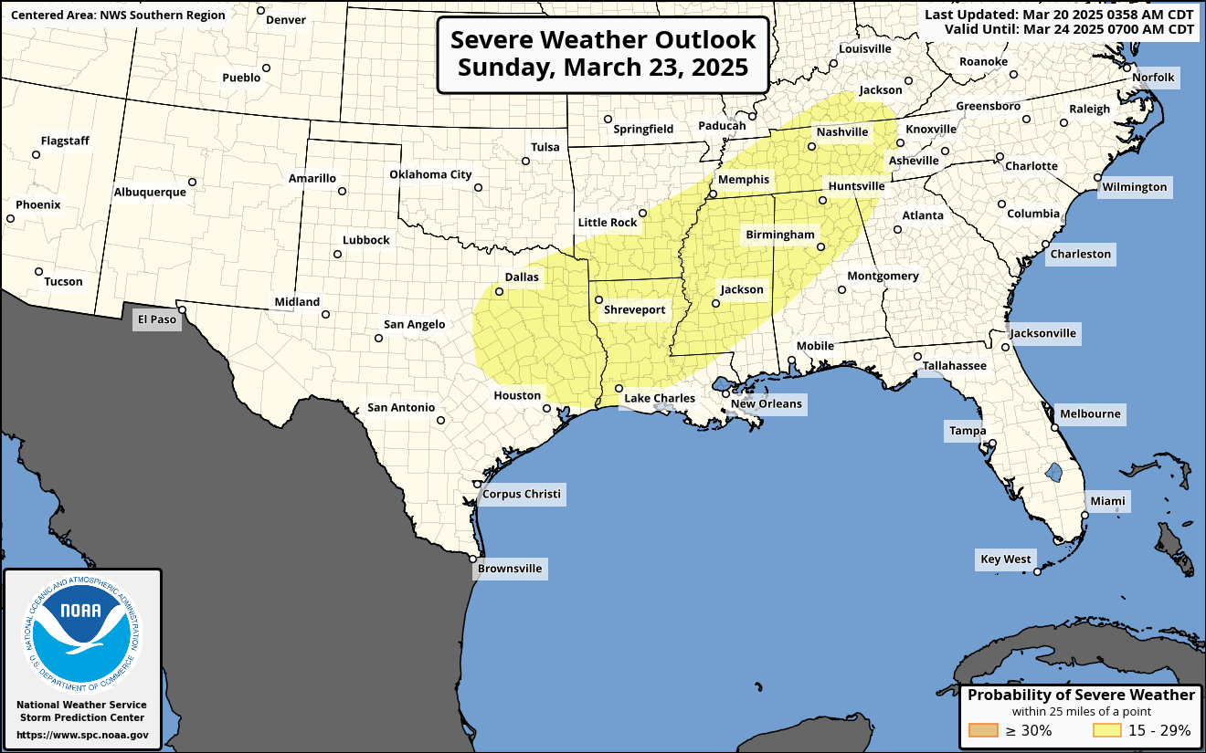
And the Storm Prediction Center has outlooked a good part of the Southeast/Ark-LA-Tex region for a basic 15% risk of severe thunderstorms Sunday/Sunday Night.
This covers just about the entire state of Tennessee, about the Northern 2/3 of Alabama, basically all of Mississippi, Southern Arkansas, Louisiana, and much of East Texas. Over the next couple days, they will fine-tune the details of this severe weather forecast. For now just know that Sunday evening/night does carry some potential for severe thunderstorms around here. It could get organized somewhere in this broad outlook area, and we'll just have to keep an eye on it. It's probably going to be a squall line coming through with low instability/fairly high wind shear.


Overall Monday looks mostly sunny, could have isolated showers linger some in the morning, but even that's dicey. Look for a High in the mid-60's, Low of about 50 or so.


Then on Tuesday, high pressure will be centered over Tennessee and Kentucky. We'll see sunny skies and a High near 70, Low near 40. So if you're waiting for calmer, more comfortable weather this Spring, it's coming, it just takes a while sometimes. And things are always changing this time of year, we all know that. The weather really doesn't get boring until we get into Summer. Sometimes that might as well start in May, so you can always hope for that if that's your thing.


High pressure will stay in control of our local weather on Wednesday as well, with a High near 70, Low in the mid-40's, sunny skies.


Then we get another cold front on Thursday. Temperatures should stay similar and will keep rain chance low for now at 30%.

Rainfall totals should average between a half-inch and one inch for this forecast period, next seven days.
But now let's look into the land of almost reading tea leaves, beyond seven days.


Friday the 28th looks like a mostly clear day with a High in the mid-70's, Low in the upper 40's, near 50 because of moisture left over from Thursday.


And then Saturday the 29th we have another system coming through, so would put a rain chance of 20-30% in forecast. High in the upper 70's, Low in lower 50's according to the super-long-range NBM guidance.


Then Sunday it looks like the front washing out as it moves through the area, so maybe just a 20-30% chance of rain again, Highs in upper 70's, Lows in mid-50's.
This is really far out there, but I may try to work it into the real forecast above anyway. Just understand that beyond 10 days, you're looking at general trends, not as many details are going to be as accurate as the first 1-3 days or even the 4-7 day stretch. But at least now we can have some idea of 8-10 days. Wasn't always that way. That's why I'm hoping the National Weather Service stays intact enough we keep getting these good observations, improvements in model guidance, and so on.
If you'd like to support this blog and these weather efforts, you can do so above, or the bottom one, you can just follow me on the tweeter-x-marks-the-spot-thingee. This may sound like an obvious statement, but I post more often, with more enthusiasm, when I can see that people are actively engaged in what I'm doing and getting some good out of it. At this point I'd need to take a remedial course in how to make YouTube videos like I did in the couple years of college I made it through, so for now it's just a lot of text, hopefully explaining things without getting too verbose, as a dear relative of mine has often described me, but said I managed to avoid it on here. All right, have a great weekend.
And now it's nearly 1:30 PM, been working on this a while, and decided to adjust a few things from in the discussion before publishing the final forecast. Putting next Thursday's rain chance at 40% based on past experience and just how the pattern looks more than on model guidance. And then for the "tea leaves" section, going with probabilities, 30% for that Saturday, 20% for Sunday. And questioning whether a 10-day-forecast is ever reliable this time of year. The models did pick up on Saturday's severe weather threat when it was about 10 days out though.
And I'm surprised to see that Patreon page has been dead for a couple years. Seeing if it's worth bringing back to life.


No comments:
Post a Comment