The reassessing this event can come later.
For now, the high points of the forecast:
Rest of today, the rain will gradually be tapering off with a High near 73.
Tomorrow will be sunny with a High between about 72 and 75, the Low about 40-43.
Overall Wednesday looks like a mix of sun and clouds during the day, High in the lower 80's, Low near 60, or at least upper 50's.
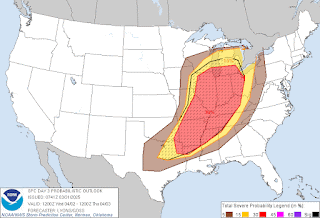
Wednesday night into Thursday, we'll have to watch for severe thunderstorm potential again. The greatest threat is going to be to our Northwest, but the threat clips our region enough that it's worth paying attention to.
The coverage of showers and storms does not look too impressive though, so even if we have severe thunderstorms, they should be pretty widely scattered, like on stormy summer days.
Looks like a 30% chance of rain (and storms) Thursday with a High in the mid-80's, Low in the mid-60's. Some places may set new record highs late this week.
Basically the same for Friday except the Low might actually be in the upper 60's, High could edge into upper 80's.
Then looking at mid-80's/mid-60's again Saturday with about a 40% chance of rain/thunderstorms.
Sunday it looks like the front is finally able to pass through the area, and rain is likely with the High falling back to about 70, the Low to about 60. And then we'll see about the following week, how much of a cool snap we get. Will speculate on that more this evening. Seems like some of the long-range NBM guidance had our Highs in the 60's, which is sort of unusual for early April. But it can happen. Sometimes we've even got a freeze in the last week or two before we clearly make the transition to warm weather. First couple weeks of April, can still get a surprise.
Not going to look at it in detail this morning, but man, what a severe weather event this was across several states. Just looking at all the hail reports and wind damage reports, that is a lot. Only a few were thought to be tornadoes, some were already confirmed as tornadoes, but this was a significant event even without those.


No comments:
Post a Comment