

FORECAST:
Sunday (High 51, Low 28): Sunny. Cold.
Monday (High 60, Low 31): Partly cloudy. Cold in the morning, cool in the afternoon.
Tuesday (High 70, Low 47): Windy and warm with thunderstorms likely in the evening and night hours. Some thunderstorms may become severe, the main threat being damaging winds.
EXTENDED OUTLOOK:
Wednesday (High 61, Low 52): Mostly sunny.
Thursday (High 54, Low 35): Sunny.
Friday (High 62, Low 36): Partly cloudy.
Saturday (High 64, Low 45): Partly to mostly cloudy with a 40% chance of showers/thunderstorms.
PRONÓSTICO:
Domingo (Máxima 51, Mínima 28): Soleado. Frío.
Lunes (Máxima 60, Mínima 31): Parcialmente nublado. Frío por la mañana, fresco por la tarde.
Martes (Máxima 70, Mínima 47): Ventoso y cálido con tormentas eléctricas probables en la tarde y la noche. Algunas tormentas eléctricas pueden volverse severas, la principal amenaza son los vientos dañinos.
PERSPECTIVA EXTENDIDA:
Miércoles (Máxima 61, Mínima 52): Mayormente soleado.
Jueves (Máxima 54, Mínima 35): Soleado.
Viernes (Máxima 62, Mínima 36): Parcialmente nublado.
Sábado (Máxima 64, Mínima 45): Parcialmente a mayormente nublado con un 40 % de probabilidad de lluvias/tormentas eléctricas.
NOTES:
There is a SKYWARN class on Tuesday March 11 at 6 PM at the Alabama Music Hall of Fame in Tuscumbia. Remember that these classes are free, courtesy of the fine folks at the National Weather Service office in Huntsville and local Emergency Management. Not only is it enjoyable to learn about severe weather and what to look for in the sky, it helps us all out to have more reliable storm spotters out there. There are also online classes being offered by the Birmingham and Nashville offices.
There is much weeping and gnashing of teeth about the budget cuts affecting NOAA and the National Weather Service right now, which is one more reason I think we should show them all the support we can right now, like taking a storm spotter class. I don't think anyone said it better than James Spann, and he spoke up right before the axe fell, it seems. I was also glad to find a story in which Wes Wyatt said that the Birmingham office did not appear to be losing any of their personnel any time soon; and Robert Aderholt made it clear that he realized how important the local forecasters were.
By the way, Wes Wyatt has a book out now, a memoir. I haven't had a chance to buy a copy yet, but thought I'd mention it.
I wasn't able to find the specific post, but I believe it was Dan Satterfield who posted a reminder that we can contact our Representatives and Senators to let them know that we're opposed to any cutting into the budget of essential National Weather Service workers. For most people reading this, the people you'd need to write or call would be Robert Aderholt, Tommy Tuberville, and Katie Britt.
And times are just interesting, even locally. Here is the press conference with Sheriff Matt Gentry and District Attorney Champ Crocker from a week or so ago. And here is a recording of the Hanceville City Council Meeting, which I believe took place Thursday night. It reminds me of an old black-and-white movie I saw a long time ago about police corruption, where at the end, someone said that while there were bad apples on the force that had to be held accountable, you also had to stop and think about how much worse things would be if we didn't have a police force at all. Things could really turn into a jungle, like the wild wild West, or worse. So I'm trying to see the silver lining, that the corruption in Hanceville was eventually brought to light, and that some people are working to make things better. Even while I feel the utmost sympathy for some of the people who told stories of suffering through things that really shouldn't have been going on.
Well... the final Forecast Discussion from Meteorologist in Charge John Gordon (@mammatusman). Thank you for nearly 40 years of service, including 20 years at NWS Louisville! We will all miss your dedication and passion. https://t.co/HbMrq8kZ3M pic.twitter.com/EJHtsMJGZS
— NWS Louisville (@NWSLouisville) February 27, 2025
As a great example of why we need to keep our hard-working human forecasters in National Weather Service offices, I offer the example of Mr. John Gordon, who has just retired from the NWS. If you read through his last forecast discussion of his career, it is so clear: A machine cannot do this. And he was the Meteorologist in Charge of the Huntsville office that opened in 2003, thanks to Bud Cramer and I believe some people at UAH collaborating.
Regardless of whether you're under the Red Flag Warning, please understand that the risk of wildfires in our area is high right now, as it's been two weeks or so since we saw any significant rain. And I join the forestry folks and other weather folks in asking people to please not burn anything unless you absolutely have to, and even then, be very careful. Be able to put the fire out if need be, and it's really better if you don't burn anything until after we get the rain Tuesday/Tuesday night.
The weather radio transmitters in Arab and Winchester have been restored to service in a very timely manner, yet another thing underlining why our NWS personnel and the people who work with them on these things are to be appreciated.
Last but not least, we do have some threat for severe thunderstorms Tuesday evening/night, so it's a good time to go over your safety plan beforehand. Review it with your family or any close friends that may be visiting then, and if we have problems that night, you should be fine.


Then traversing the rest of the region for some of our neighbors, Fort Payne got up to 65 degrees today after a morning Low of 32, right at the freezing mark up there in Appalachiaville. Decatur had a High of 65 and Low of 49. The clouds have hung around a little longer in Huntsville, and they saw a High of 65, Low of 41 today. Then over at Muscle Shoals, the High was 64, Low 46. Tupelo had a High of 66 and Low of 51. Memphis is another mostly cloudy site today, where most of us in the region had plenty of sunshine, High of 60 and Low of 49 there. Clouds have also been breaking up more gradually in Nashville, which saw a High of 62 back around Midnight and is currently at 48 degrees, their Low so far today.
So they are partly cloudy in Nashville at this hour (4 PM) at 48 degrees. The dewpoint is 20 degrees, making the relative humidity 33%. Winds are out of the Northwest at 20 miles an hour with gusts up to 25 mph. That makes for a wind chill value of 42 degrees. The pressure is 30.06 inches/1017.8 millibars and rising. Visibility is ten miles.
And what the heck, I'll do Cullman's observations too, since I didn't above. Anyway, the temperatures are going backwards for Nashville today. That's why I singled them out.
So as of 4:15 PM it is sunny and 59 degrees in Cullman. The dewpoint is 27 degrees, making the relative humidity 29%. Winds are Northwest at 14 mph, gusting to 25 mph. The pressure is 29.95 inches, which I believe is 1014.2 millibars and rising slowly. The visibility is a perfect 10 miles.
And you really do need a good grasp of the current weather to predict the future weather. That's why when I have time, at least once a week, I spend some extra time on it. That's also what some people are missing when they think it doesn't matter that drastic, sudden budget cuts to NOAA/NWS have ceased upper-air radiosonde balloon launches in Alaska. As Dan Satterfield pointed out a day or two ago, that site in Alaska was providing the only upper-air data for many miles (or kilometers, his preference since it's what is used more globally) around. Losing even one site diminishes the quality of the forecasts we get from our computer models, where this data is fed in several times a day. And through complex equations, they forecast the future states of the atmosphere. Now they are going to have less to work with. Nothing much I can do about that, but it is a reminder for human forecasters to make the best diagnosis of the atmosphere they can at the moment before just relying so much on the numerical models.
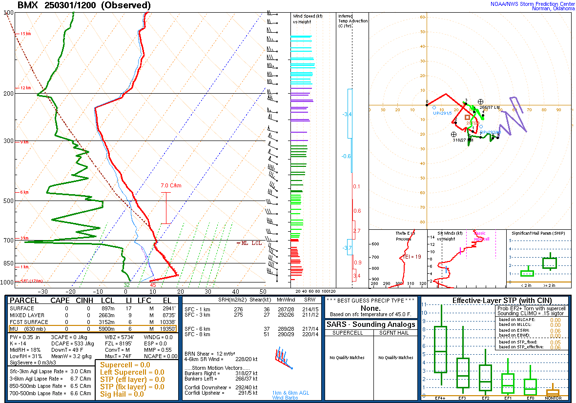
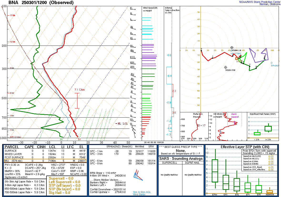
Here are this morning's 6 AM balloon soundings data from Birmingham and Nashville. We actually already needed more of these, not less. Right now the air is stable, and it's just turning cold again and pretty breezy. But on high-impact weather days, these things tell us a lot more. And sometimes extra balloon launches are made in real-time to better assess the threat for severe weather. I know Birmingham does a lot of those when they are needed.


Tomorrow we've got high pressure moving through Kentucky and just a clear, cold day around here. We'll see a High of about 51-52, Low of about 27-28. The winds will die down, although we'll still have a good northerly breeze tonight.


On Monday as the high pressure moves up toward New England we'll have some clouds come back, a mix of sun and clouds overall, the High temperature near 60, the Low in about the 30-33 degree range.


Then on Tuesday, look at that upper-level trough axis taking on a strongly negative tilt in the Plains/Mid-South, with a deep surface Low pressure system centered up in Eastern Kansas and around Kansas City, Missouri.

The NAM has a similar look. This system is just barely within its range now. Since it's a mesoscale model for North America, when you get out to three days, it becomes less reliable sometimes compared to global models. But it's in good agreement with the GFS here even three days out. And in the 24-60 hour range, it can be a great model, sometimes picking up on stuff the globals don't.
Anyway to just paint Tuesday with a broad brush stroke for now around here, expecting a windy, warm day with a High about 69-70, the Low in the upper 40's. And in the evening or maybe the late night hours, a line of thunderstorms is expected to move in, what we call a squall line, or some people like to be fancy and call it a Quasi-Linear-Convective-System. Most people just call that a QLCS, and I'll let you figure out why. I usually just call it a squall line, the time-honored term, because it's the same thing, and sounds more descriptive to me of what the thing is. Some storms within this line could become severe, as we've been discussing for several days now. It is looking fairly similar to the event we dealt with on February 15, a lot of the same setup. Of course each event is unique. And we see a lot of threats like this around here, especially in March and April, sometimes into the month of May, but basically in the spring-time.


High pressure moves in from the Mid-South on Thursday, and we'll be sunny with a High in the lower-to-mid-50's, the Low in the mid-30's.


Friday is another day we're in between systems, sort of like this Monday, so calling for partly cloudy skies, a High in the lower 60's, Low in the mid-to-upper-30's.


On Saturday, the GFS is now not showing the next storm system affecting us on Saturday after all.


The ECMWF does, and it tends to do better with such things at this time range.
Will introduce a 40% chance of rain with a High in the lower 60's, Low in the mid-40's.

Rainfall totals for this forecast period will probably average about one inch for most of us, certainly looks that way for folks on the Tennessee side, but as you get into Central Alabama and a few pockets of North Alabama, slightly greater chance of seeing rainfall totals closer to 1.5 inches. And we do need the rain right now.
MESOSCALE DISCUSSION:


At Midnight between Tuesday/Wednesday, the SREF is advertising a setup much like a couple weeks ago, where we have way more than enough wind shear to support severe thunderstorms, including the kind we'd look for to cause tornadoes, but our unstable air looks to be lacking, with CAPE values struggling to even get up to 500 j/kg.

The NAM is showing CAPE values struggling to even each 300 j/kg in North Alabama by Midnight, but with higher values of 500 units or above back in Mississippi, including Northern Mississippi.

.png)

A forecast sounding for Cullman at 9 PM shows only a marginal threat for storms becoming severe, the main threat being damaging winds. And it is going to be a windy day and night, even outside of the line of storms. The National Weather Service in Huntsville is already thinking about putting us under a Wind Advisory on Tuesday/Tuesday night.


The really hot zones for this severe weather event will probably be in Mississippi, Arkansas, Northern Louisiana, and around places like Memphis, Tennessee. That's where the most unstable air looks to be available on Tuesday and where supercell thunderstorms are most likely to initially form.
What we'll get Tuesday evening or maybe even late Tuesday night is probably going to be the squall line that all these storms have gradually merged into, which will still carry a risk for thunderstorms becoming severe. The most likely threat is looking like damaging straight-line winds, but we certainly can't rule out a few isolated tornadoes. We had that in the event a couple weeks ago, February 15. And even if a tornado only lasts a few minutes, if it hits your block, it's a big deal to you and the people around you. So I'd say that even though this looks like a routine severe weather risk for our area (TN Valley), I would respect it. Have a reliable way to get alerts Tuesday evening/night, and have your safety plan ready to get to a reasonably good shelter within five minutes if you go under a warning. Even if you "only" get a severe thunderstorm warning out of this event, I wouldn't stay up on a top floor or near some windows. Especially if you've got trees around, I'd get to that lowest, most central room of your home. If it's a smaller room or hallway, that's better, because even if a tree falls, the walls are less likely to collapse than in the wide open rooms like a living room.
On Wednesday even by 6 AM it looks like the severe thunderstorm threat will shift to the Mid-Atlantic Coast.


No comments:
Post a Comment