

FORECAST:
Friday (High 65, Low 34): Partly cloudy and breezy. Becoming mostly cloudy in the evening.
Saturday (High 64, Low 50): Mostly cloudy during the day. Rain is likely at night, and isolated thunderstorms are also possible.
Sunday (High 55, Low 43): Gradual clearing, becoming partly to mostly sunny. Widely scattered showers may linger through at least the morning hours.
EXTENDED OUTLOOK:
Monday (High 64, Low 36): Sunny.
Tuesday (High 71, Low 38): Sunny.
Wednesday (High 74, Low 42): Mostly sunny.
Thursday (High 72, Low 51): Partly cloudy with a 20% chance of showers/thunderstorms.
READING TEA LEAVES:
Friday March 14 (High 74, Low 52): Mostly sunny.
Saturday March 15 (High 72, Low 54): Rain and thunderstorms likely.
Sunday March 16 (High 66, Low 44): Mostly sunny.
PRONÓSTICO:
Viernes (Máxima 65, Mínima 34): Parcialmente nublado y ventilado. Mayormente nublado por la noche.
Sábado (Máxima 64, Mínima 50): Mayormente nublado durante el día. Es probable que llueva por la noche y también es posible que haya tormentas eléctricas aisladas.
Domingo (Máxima 55, Mínima 43): Despeje gradual, tornándose parcialmente o mayormente soleado. Es posible que haya lluvias muy dispersas durante al menos las horas de la mañana.
PERSPECTIVA EXTENDIDA:
Lunes (Máxima 64, Mínima 36): Soleado.
Martes (Máxima 71, Mínima 38): Soleado.
Miércoles (Máxima 74, Mínima 42): Mayormente soleado.
Jueves (Máxima 72, Mínima 51): Parcialmente nublado con un 20 % de probabilidad de lluvias/tormentas eléctricas.
LEYENDO LAS HOJAS DE TÉ:
Viernes 14 de Marzo (Máxima 74, Mínima 52): Mayormente soleado.
Sábado 15 de Marzo (Máxima 72, Mínima 54): Probabilidad de lluvia y tormentas eléctricas.
Domingo 16 de Marzo (Máxima 66, Mínima 44): Mayormente soleado.
NOTES:
Here is an interview with John Gordon, who recently retired from the National Weather Service in Louisville, KY and was the first Meteorologist-In-Charge at the National Weather Service in Huntsville when they got their first really nice office in 2003.
The American Meteorological Society has issued a statement about how essential NOAA/ the National Weather Service is.
Bryan Norcross has written an essay about how they were similarly threatened in the 1990's.
Meanwhile our local offices continue to do a great job. The National Weather Service in Huntsville is hosting a SKYWARN class at the Alabama Music Hall of Fame in Tuscumbia this coming Tuesday at 6 PM. Remember that these classes are free. They are fun to take and teach you a lot about severe weather and what to look for in the sky, as well as safety. You can also take online classes like this from either the Birmingham or Nashville offices.
The latest episode of Weatherbrains featured Pete Wolf, a long-time veteran of the National Weather Service who talked mainly about interpreting radar data correctly and forecasting storms. They did talk a little about the ordeal the NWS is going through, but the topic is so politically charged and contentious that I think most people are keeping their mouths shut because they don't want to deal with the backlash. Maybe they're just accepting what they can't change. Seems like Troy Kimmel spoke his mind a bit, as he usually does.
Just a reminder that Daylight Savings Time (which is something that I can't change, but would eradicate if I could) starts this Sunday morning (March 9) in the dark hours. So if you need to "spring forward" any older, more analog clocks, Saturday night is the time to do it. A lot of people say it's a good time of year to change out the batteries in your NOAA weather radio and check other things like smoke alarms to make sure they have fresh batteries and are in good working order.


It has been a sunny day overall in the Tennessee Valley, a few fair-weather clouds at times. I think I noticed a good bit of cirrostratus around here. The High in Cullman was 54 after a morning Low right at 32, the freezing mark. We've had a pretty good Northwest breeze today making it feel colder. Wind chill values were in the 40's much of the day. Jasper saw a High of 57 and Low of 30. Haleyville had a High of 54 and Low of 31. Fort Payne had a High of 52 and Low of 36. Decatur saw a High of 54, Low of 34. Huntsville had a High of 53, Low of 33. Muscle Shoals had a High of 54, Low of 35. Tupelo made it up to 57 after a morning Low of 35. Memphis saw a High of 52, Low of 34. And Nashville had a High of 53 and a Low of 36 today.
We have high pressure moving back into the region today and a ridge over much of the country. The Storm Prediction Center only had an outlook for general thunderstorms today along and West of the Rockies back into parts of California, nothing severe anywhere in the country. So this is a quiet pattern we're in at the moment. But you know how this time of year is, things always changing. So let's look at the changes in detail, whether they're benign and mild changes or more drastic ones. We might have both before this forecast period is over, because I'm going to try to look out 10 days this time.

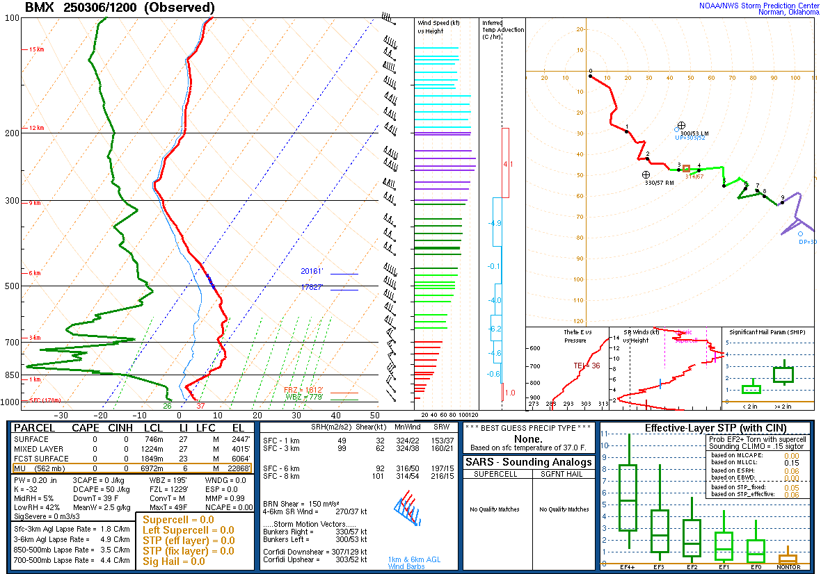
The upper-air data from 6 AM this morning out of Birmingham and Nashville support this picture of a cold, stable airmass in place for now.


Tomorrow the high pressure is expected to move out into the Gulf and Atlantic waters. We'll see a mix of sun and clouds, maybe more clouds toward the evening hours. And it'll be breezy again even though winds will be southerly, not northerly like today. High temperature should be about 65, Low tonight/in the morning about 34.

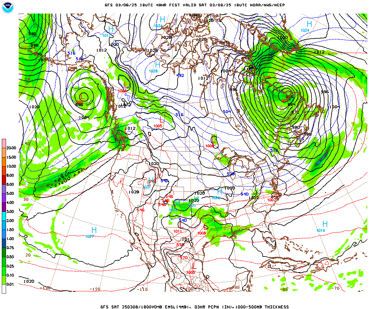
And it's looking more and more like Saturday will be dry during the day. We've got agreement from the NAM on that, showing the GFS here.

Then showing the NAM for Saturday night at Midnight/going into Sunday morning. And we'll have rain around here. It doesn't look as heavy or widespread as we get with a lot of systems this time of year. Saturday looks like a mostly cloudy but dry day. Then Saturday night we're probably going to see numerous rain showers over the region. May cap the probability at 50%, but nah, with this setup, might as well say that rain is likely, about a 60% chance for any one spot getting a shower. So most of us will see some rain. It doesn't look especially heavy with this event. High for Saturday should be about 64, Low of about 50 or 51. Severe thunderstorms are not a concern with this, most of it just being a cool rain, but some general thunderstorms are possible.


Any severe thunderstorms will stay down near the Gulf Coast with this system, and even there, the threat is marginal.


A big question is how fast does the moisture clear out on Sunday. The GFS keeps showing it clearing out more gradually, which is worth paying attention to, since the American model does have a reputation for trying to rush things. And it isn't here.

We've actually got pretty decent agreement from the NAM this time.

The European ECMWF shows much less rain lingering around here at Noon Sunday. But at this time range, in this setup, I think the American Global and North American Mesoscale Model are more reliable. Going to bump the chance of lingering showers on Sunday up to 30%. And expecting a High in the mid-50's, Low in the lower 40's.


Monday we are definitely in the clear with sunny skies again, the High in the lower-to-mid-60's, the Low in the mid-to-upper-30's.


Then on Tuesday, High pressure in the Gulf, sunny skies around here, High of 70 or so, Low in the upper 30's.


Should still be mostly sunny on Wednesday even as the High pressure exits stage right on the map. Expecting a High in the lower-to-mid-70's, a Low coming up into about the lower 40's.
Notice that upper-level trough over Texas and our upper-level winds steepening from the Southwest ahead of it, bringing us warmer, moist air.


But the rain with this system looks meager on the GFS (shown above) and the ECMWF. If we have a period of heavier rain, it'll probably be overnight between Wednesday and Thursday, according to this latest model guidance. But for Thursday only going to include a 20% chance of showers and maybe a thunderstorm, a High in the lower 70's, Low about 50 or so.
And now we head into the land of tea leaf reading. Actually there is some science behind it, but please keep in mind that computer model guidance, even the best, can decrease in accuracy once you get beyond seven days in the future.


So here we are on Friday March 14 with a storm system traversing the Rocky Mountains. Around here looks like a mostly sunny day behind that last system, High in the mid-70's, Low in the lower 50's. Using the NBP and some other National Blend of Models products (that I'm still learning my way around, just looked at Model Output Statistics for a long time) for this long-range temperature guidance. I did look at a couple of TV stations and their 10-day forecasts, but I personally think they are off base here. The gist of the NBM guidance fits better with what I'd expect with the pattern.


Then on Saturday March 15 that system looks like a fast mover, longwave negative-tilt trough over the Central United States, the surface Low moving way up into the Dakotas, trailing cold front down this way going to bring us some showers and thunderstorms. This has generated some social media buzz, but it really doesn't look like a classic severe weather setup for our region. It's too soon to call one way or the other, of course, being more than a week away, but if these model projections of the atmosphere turn out to be right (and the ECMWF does agree pretty well with the GFS look here), then this is just one more system to keep an eye on. Nothing jumps out and makes an experienced forecaster go NOOOO - MAJOR SEVERE WEATHER! Only amateurs are thinking that way at this point. Though it does look like it could bring some heavy rain. Plus the NBX guidance for Cullman is showing a High near 70, Low in lower 50's. That looks like another setup that is marginal for stronger storms that might become severe. Given the time of year, it is something to keep an eye on, in case it does look more concerning in future model runs. But right now, it looks like a pretty typical cold front bringing us showers and storms this time of year, where we do have to watch in case any become severe. But based on the information we have right now, I would lean toward any severe thunderstorm threat being on the low end. The synoptic setup with the Low being that far displaced to our North doesn't even make it look like a big severe weather potential around here. That would have to change in future model runs, or at least some other details change, before I'd be on board with this Four Horsemen mentality that a few people have posted about. I don't see as much of the hype as people who are on social media 24/7. But the people spreading it need to settle down on this one. Just evaluate it carefully from day to day. Doesn't look overly concerning for now, just something to watch. If you're going to worry about it, worry about flash flooding, because that looks a lot more likely at this point than severe thunderstorms.


The American model shows the front passing through here by Sunday.

The European model not only agrees but blows it through here a little faster, which is unusual. It's usually the other way around. The GFS did get an upgrade a few years ago, so maybe a lot of its quirks were ironed out.
Anyway forecasting mostly sunny skies for Sunday with a High in the mid-to-upper-60's and a Low in the lower-to-mid-40's.
And after all that analysis, please keep in mind that you do have to take Days 8-10 of any forecast with a grain of salt. We can see general trends with these awesome computer models these days, but it's not going to be as accurate as the forecast for the next 3-4 days, not any time soon.
Started to show severe weather parameters for March 15 from the GFS, but I think that would be taking it too far, to where it's just absurd. Even if you showed all that and nitpicked over the details, you'd still be left with the idea that any severe thunderstorm potential in the TN Valley would be marginal. Based on the information/guidance we have now. It's really too soon to know what it's going to do. But these are the most likely trends.
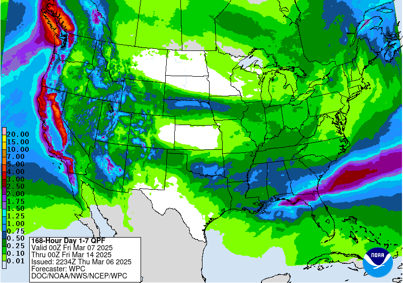
For the next seven days (not ten days), the WPC is predicting about up to a half-inch of average rainfall totals for North Alabama into Southern Middle Tennessee. It's not much considering how dry we've been overall lately, but we'll take what we can get. Maybe that mid-month system brings more significant rain, regardless of whether we deal with stronger storms in the mix. We need the rain.
If you'd like to support this blog, please consider dropping a dollar in my bucket using the link above. Since the weather has calmed down with nothing high-impact on the immediate horizon, I'm taking some time off from this.
And I'm not in the mood to do any social commentary either. Figure out the news for yourself, or watch something more pleasant . . . wait, not quite that pleasant . . . what did I see in your imagination when I was reading those tea leaves for the 10-day . . . Sofia Vergara joining the reboot of Baywatch? Get your minds outta' the gutter. Although the political bickering is much more of a gutter than a beautiful, graceful lady with dark skin in a bikini. I'd rather see SpongeBob in the Bikini Bottom than scroll social media lately. If it makes you mad enough to want to strangle someone, may I suggest the old Alfred Hitchcock show . . . ? You can stream it on Roku. Okay, but seriously, be well, over and out.


No comments:
Post a Comment