Wednesday (High 71, Low 44): Sunny. Mild.
Thursday (High 75, Low 43): Sunny. Mild.
Friday (High 78, Low 54): Partly to mostly cloudy. Warm.
Saturday (High 74, Low 58): Partly to mostly cloudy with a 40% chance of showers/thunderstorms.
Sunday (High 80, Low 60): Partly to mostly cloudy with a 40% chance of thunderstorms - some could be severe.
Monday (High 72, Low 57): Partly cloudy with a 30% chance of showers/thunderstorms.
Tuesday (High 69, Low 48): Partly to mostly sunny with a 20% chance of showers.


We'll have high pressure in place behind the front tomorrow, looks like another sunny day, High near 70-71, Low about 44-45.
Then as the high pressure moves to the East on Thursday, still sunny skies, High of about 75, or mid-70's anyway, Low about 43-45 range.
Then skies become partly to mostly cloudy on Friday in advance of our next storm system with a High in the upper 70's, a Low rebounding to about the mid-50's.

Saturday it looks like we will see scattered showers and thunderstorms coming back, chance of rain about 40%. High should be in the lower 70's, Low in the upper 50's.


The day Sunday is looking dry on this latest GFS model run.


Whether you look at that or the ECMWF, it shows a line of storms coming in about 1 AM going into Monday morning. And if this timing is correct, it could have a big impact on the severe weather threat.
Interesting to note that the Storm Prediction Center took away the severe weather risk for Saturday (for states to our West/Northwest) because it was looking more like the atmosphere would stay capped, with an inversion layer of warm air preventing severe thunderstorms from getting organized.
Will maintain a 40% chance of rain for Sunday and may mention chance of severe thunderstorms. High should get to about 80, the Low near 60.


The GFS does show enough a combination of unstable air and wind shear to be concerned about 1 AM Monday. Taking a forecast sounding near Waynesboro where the parameters seem to be maxed out (more than surrounding areas I mean), it shows moderately unstable air, pretty strong wind shear including low-level helicity, and a STP of 1-2. So this would support a threat for severe thunderstorms capable of damaging winds, large hail, and isolated tornadoes. Overall the setup doesn't look as dangerous as it did yesterday, but I guess that's the nature of trying to speculate on details too soon using global model guidance. Really we won't have a great look at mesoscale details until Thursday or Friday. The instability has gone down for this event via the GFS because of the slower projected timing (during the dark hours), but the wind shear has come up. And there'll be better lift if this timing is right because the front will be approaching.
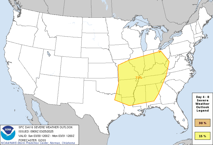

The Storm Prediction Center has us under a Basic 15% Risk of severe weather for the period 7 AM Sunday to 7 AM Monday. And then the following 24-hour period, that risk shifts over into Georgia and the Carolinas, Virginia.


Since the timing is uncertain, will keep a 30% chance of rain in for Monday with a High in the lower 70's, Low in the upper 50's.
This is starting to look more like an unsettled pattern with strong storm potential reminiscent of 2009 in some ways. But we'll see how things trend in future model runs.

The rain chance for Tuesday, will trim back to 20%. Should see a High near 70, Low in upper 40's. Front should be down around Mobile but may have some wrap-around showers.
Really the period Saturday through Tuesday looks unsettled and uncertain for this forecast.

Rainfall totals will average between about a half-inch and one inch for this forecast period.
There are still a few SKYWARN classes left this season, next one in Rainsville Thursday evening.
The National Weather Service offices in Birmingham and Nashville have put together summaries of the March 15 tornado outbreak.
NWS Nashville is also doing their online Weather101 classes again.
No comments:
Post a Comment