

FORECAST:
Tuesday (High 72, Low 39): Sunny. Mild.
Wednesday (High 83, Low 58): Breezy, turning muggy, partly to mostly cloudy. Widely scattered showers and thunderstorms are possible, especially at night, and where they form, they could become severe.
Thursday (High 86, Low 65): Partly cloudy. Isolated showers and thunderstorms are possible - storms could be strong where they form.
EXTENDED OUTLOOK:
Friday (High 85, Low 66): Partly cloudy with a 20% chance of showers/thunderstorms.
Saturday (High 84, Low 67): Partly to mostly cloudy with a 30% chance of showers/thunderstorms.
Sunday (High 71, Low 63): Rain likely - thunderstorms possible.
Monday (High 62, Low 43): Mostly sunny.
PRONÓSTICO:
Martes (Máxima 72, Mínima 39): Soleado. Templado.
Miércoles (Máxima 83, Mínima 58): Ventoso, tornándose bochornoso, con cielo parcialmente nublado. Posibles lluvias y tormentas eléctricas dispersas, especialmente por la noche, que podrían volverse severas donde se formen.
Jueves (Máxima 86, Mínima 65): Parcialmente nublado. Posibles lluvias y tormentas eléctricas aisladas; las tormentas podrían ser fuertes donde se formen.
PERSPECTIVA EXTENDIDA:
Viernes (Máxima 85, Mínima 66): Parcialmente nublado con un 20% de probabilidad de lluvias/tormentas eléctricas.
Sábado (Máxima 84, Mínima 67): Parcialmente nublado con un 30% de probabilidad de lluvias/tormentas eléctricas.
Domingo (Máxima 71, Mínima 63): Probabilidad de lluvia y tormentas eléctricas.
Lunes (Máxima 62, Mínima 43): Mayormente soleado.
Here is some information on last night's and this morning's storms, several tornadoes confirmed in Middle Tennessee as well as a tree down and a lightning strike to a home in Huntsville, some flooding issues. It was a fairly wild ride at times.
Next SKYWARN class is Thursday April 10 6 PM in Hartselle at the Oak Ridge Fire Department. Then within a week or two after that, they're going to hold two classes for deaf-and-hard-of-hearing people in Decatur and Tuscumbia, the latter location being all too appropriate. I'm glad NWS Huntsville does that though seriously.
The National Weather Service in Birmingham posted a great summary of the March 15 Tornado Outbreak, which is still in their headlines, worth checking out if you haven't already. We did have some people lose their lives in these tornadoes, and it's always good to try to learn from that, if anything could have gone different. In one case, I saw a news story the day after the event where a guy who had gotten to a storm shelter told about a neighbor who was in a mobile home that was destroyed.
Middle Tennessee's drought conditions are on the better end of the spectrum thanks to all this rain lately.
NWS Nashville is doing Weather101 classes again. They are free to take online. Especially if you know a kid in your family who's into weather, this could really get somebody started. The classes are certainly thorough enough that the adults are not going to fall asleep through them either. This is not "weather for dummies". This is good stuff.
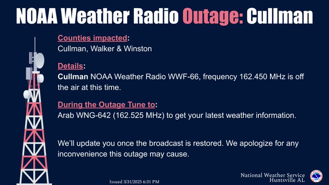
Remember that the Cullman NOAA Weather Radio transmitter is down. They hope it's fixed tomorrow. But no guarantees on that. Besides, tomorrow is April Fools Day, so how would we really know to trust it was back online . . . ? Nah, but seriously, here is some information on how to use backup transmitters. The Arab one didn't pick up so well for me, so I used the Oneonta one for this last severe weather event.
DISCUSSION:
So we had an overcast, breezy day in Cullman today. Of course we had the strong thunderstorms in the morning, which stayed below severe limits right around here. Our High today was 72, and the Low so far is the 7:15 PM temperature of 55. It's one of those days the temperatures go backwards after just fluctuating up and down recklessly. We've had fog, mist, and even light rain throughout the whole day basically, periods of it, sometimes restricting our visibility a lot. Though it's currently back to a perfect 10 miles.
Let's look at yesterday, because I'm curious. Looks like yesterday's High was 72 with a Low of 63. I think I forecast High of 75 and Low of 61 or 62, but I'd have to go check. That severe weather event could have been a lot worse for us, but it looks like for the tornado threat, Middle Tennessee may have gotten the worst of this one. We'll see about places like Indiana or Missouri as more storm surveys come out from there, but a lot of their stuff was just large hail and damaging thunderstorm winds, straight-line winds. There were a ton of those reports, really widespread.


This forecast discussion is going to just kind of hit the high points rather than go into a ton of details like recent ones. We're going to get a break in the action tomorrow, expecting sunny skies and a High near 72, morning Low near 40.
Then things get complex. We definitely have a surge of warm, humid air coming in starting Wednesday. But the latest guidance is making it look questionable how much rain can get in here versus how much is kept at bay by a high pressure system to our South and East blocking things, a lot like in a summer pattern. Look for a High in the lower 80's and Low in the upper 50's Wednesday. Which is warm even for early April. Some places will probably set new record Highs during this forecast period.
I'm not ready to totally abandon rain chances for Wednesday but will keep them at 20%.
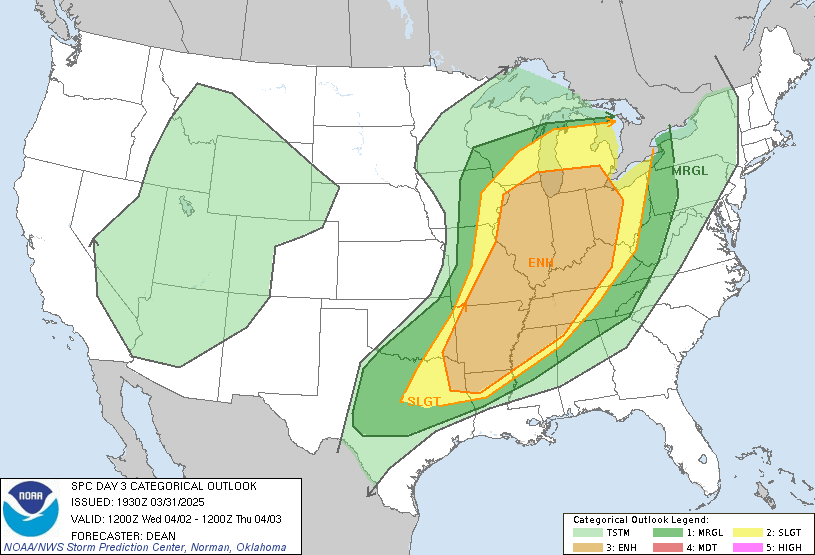
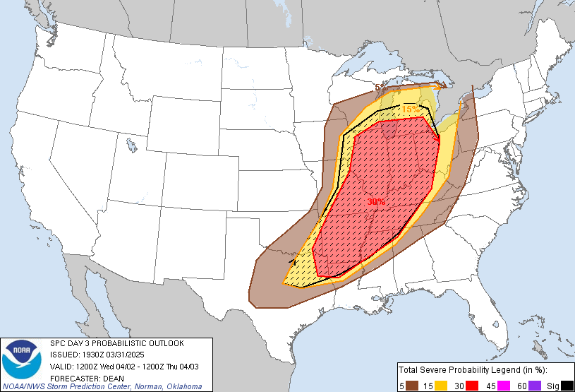
Here's the problem: A widespread outbreak of severe thunderstorms is expected again Wednesday/Wednesday night over several states, basically the same ones covered by this event we just got through with. And any storms that do manage to get in here could easily reach severe limits.


That's especially true for far Northwest Alabama up around Florence up to Lawrenceburg, Waynesboro, up into the majority of Middle Tennessee, also back into Northern Mississippi, where supercell thunderstorms could initialize or sustain in that general zone.
So it's a tricky situation where even if the storms stay really isolated, the ones that can overcome that high pressure ridge that'll build in here could really pack a punch. I've seen it happen before, but it's fairly rare, where we can get a summerlike pattern in the middle of spring. And the storms are a little more dangerous than when it happens in the summer. We have better wind shear usually in the spring-time. So more of the storms become severe.


Then we have a lot of the same problem Thursday. Many of our Tennessee counties have a basic 15% risk for severe thunderstorms, and so does the Shoals area.

But how much of the rain actually makes it into Southern Middle Tennessee, much less North Alabama, to begin with?


That is a strong High pressure system centered around about Pensacola or Panama City. And it may keep a lot of these storms at bay.
I'd go with a 20-30% chance of rain/storms Wednesday and Thursday.
Look for a High in the mid-80's Thursday, Low in the mid-60's.

Basically the same Friday, similar temperatures and only a 20% chance of rain/storms.

Saturday we'll bring the rain chance back up to 30%. I think Wednesday and Saturday, a 30% chance of rain is reasonable, 20% the two days in between.
Temperatures about the same, mid-80's and mid-60's. And man, this is going to feel like some soupy air, even for early April.

Then Sunday rain is likely as the front is finally able to push through, could see a few thunderstorms in the mix too. High near 70, Low near 60 or so.

Then mostly clear skies return for next Monday, with a High of about 60 or so and a Low in the lower 40's.
The extended NBM guidance for 7-10 days is showing a few sunny days in a row with Highs in the 60's and Lows dipping back into the 30's for at least a morning or two there. We'll see if that plays out. Stranger things have happened before. Really until the second week of April, you have to look out for a late-season cold snap. It'll be quite a contrast from the almost-heat-wave we've got coming right before it. Mid-80's are not that bad around here if it's May or June, but we're not there yet. And this is going to feel muuuuuuuggggggggggyyyyyyyyyyyy . . .


And this sure is a dicey situation with the severe thunderstorm potential Wednesday into Thursday. The threat of storms is low, but where they form, they could get rough.

Rainfall totals for this forecast period will average about two inches for most of us, although a few places may see locally heavier amounts, especially in Northwest Alabama up into roughly the Western half of Tennessee.
CHATTER:
Not related to weather, just one of my lighter notes, but can we all agree that the original "American Idol", Kelly Clarkson, has the best voice on the planet? And is refreshingly classy in an era that makes it tough to pull that off . . . even if she swears impulsively at David Blaine's magic tricks? Eh? Can we? Ah well, I will pursuing a more active social life soon, but in the meantime, I share these thoughts with you. She really does nail that song. If she has a rival, the first one that comes to my mind is Dolly Parton, who recently shared a lovely tribute song to her husband after he passed away.
Trying to keep such musings separate from the weather stuff, at the bottom. Because sometimes they really go off the rails. And that needs to be kept separate from the stuff with more professionalism.
I do have some criticism for my favorite disc jockey who goes on crazy rambles, Coyote J. Calhoun. What I caught of his show last night, he said he used to work with James Spann in the 70's in radio. And told him he sucked on the air, wasn't funny, was pretty vanilla. And I think James has a great sense of humor. If he was dry back in the 70's, he overcame it over the years. I've heard him say stuff like, "Even if your dog's got gas in there with you, you still need to stay in that closet until this tornado signature is past . . ." Frankly I'm glad we've still got some people on the airwaves (Internet, TV, and radio) with some real personality like that. Even if the two guys' personalities are ostensibly very different. I think they're both hilarious when the mood strikes them. James is as good as it gets for weather, and Coyote is as good as it gets when it comes to finding great music, old and new, even if he's only allowed to play the old stuff these days and not the cutting edge stuff he used to bring to people. Most of it's rock, but a lot of it's dark wave, ambient, and just a good mix of stuff. I seem to remember a time he played classical music on one show (years and years ago) between the other stuff and would talk about the lives of the composers. That was awesome. Anyway he said he was talking to Spann about how the weather could get ugly after midnight. Coyote J. is actually kin to one of the most respected meteorologists in history, and I bought one of that guy's books this month. It was uncanny for it to be delivered in the mailbox during that Ides of March tornado outbreak. And that's my cat Salem's birthday anyway. He is two years old now. I guess that's 14 in human years, which might explain why he is as wild as ever and sort of moody, likes to stay in his room a lot and then wants to go outside at night or other inconvenient times. Hey, he's awesome though. That day when we had to shelter from what seemed to be a confirmed tornado, I went looking for him through the house. And then he ran out of the closet meowing at me. Little dude was already in there, just wondering when I was going to get in there and close the door like usual. He is as good a buddy as I've ever had in the feline way. And he sort of reminds me of the only dog I ever had in the way he's such a wild, tough little dude and so loyal, more like a dog in that way than a lot of cats. But dignified in the way cats usually are more than canines. The dog I had was a German Shepherd, so she was more dignified than, say, one of these poodles or Taco Bell dogs a lot of people have.
And with that . . . have a good evening. I'm outta' here before I say more stuff that will make somebody want to sic their dogs on me.
In all seriousness, there was a case of rabies in Alabama lately where somebody got bit by a rabid fox. So if you can, it's good to check and make sure your pets are up to date on their shots just in case. And of course, you hope they don't run into any wild animals carrying rabies anyway. I guess I never got over that old movie Ole Yeller. Keep meaning to read the book some day. But I think that was before they had shots for stuff like that. And people just had to be careful. I never forgot one character who just rambled on and on about "that hydrophoby" and how he knew this one ole' boy who got it and "chained hisself to a tree . . . till he died o' the snappin' and snarlin' fits!"
We really do live in a privileged time, and we saw over the past five years what it was like when a lot of that fell apart on the medical side of things. If the National Weather Service keeps having its budget gutted, then we're going to remember what it was like before consistent, reliable weather forecasts and severe weather updates too.
By the way, when I throw out common-sense advice, I'm not trying to be condescending. I don't even know where Salem's paperwork is from when he broke his hip as a kitten. My papers are disorganized among many drawers in more than one room unfortunately. And I probably should double-check on him and plan a checkup semi-soon anyway, even if he's up to date on those shots, as I expect he is. I think I got the one that was good for three years.
It hasn't stopped him from knocking my weather radio in the floor, but he's done that less as time has gone on.


