

FORECAST:
Wednesday (High 61, Low 50): Heavy rain with potential for localized flooding. Any thunderstorms that develop could produce strong winds.
Thursday (High 52, Low 41): Mostly sunny. Breezy and cold.
Valentine's Day (High 57, Low 28): Sunny and cold. Happy hearts possible, but broken hearts much more realistic a possibility for most.
EXTENDED OUTLOOK:
Saturday (High 72, Low 46): Thunderstorms likely - some possibly severe.
Sunday (High 51, Low 40): Gradual clearing with a 20% chance of showers.
President's Day (High 44, Low 20): Sunny.
Tuesday (High 55, Low 27): Mostly sunny.
PRONÓSTICO:
Miércoles (Máxima de 61, Mínima de 50): Lluvias intensas con potencial de inundaciones localizadas. Cualquier tormenta eléctrica que se desarrolle podría producir fuertes vientos.
Jueves (Máxima de 52, Mínima de 41): Mayormente soleado. Ventoso y frío.
Día de San Valentín (Máxima de 57, Mínima de 28): Soleado y frío. Es posible que haya corazones felices, pero es mucho más probable que haya corazones rotos para la mayoría.
PERSPECTIVA EXTENDIDA:
Sábado (Máxima de 72, Mínima de 46): Probabilidad de tormentas eléctricas, algunas posiblemente severas.
Domingo (Máxima de 51, Mínima de 40): Despeje gradual con un 20 % de probabilidad de lluvias.
Día del Presidente (Máxima de 44, Mínima de 20): Soleado.
Martes (Máxima de 55, Mínima de 27): Mayormente soleado.
NOTES:
Parts of the Tennessee Valley have been placed under a Flood Warning concerning small streams or have had a Hydrologic Outlook issued to alert people to the possibility of stream/river flooding.
It is a good time to review severe weather safety rules and know how to get a tornado warning and what you'll do if you go under one.
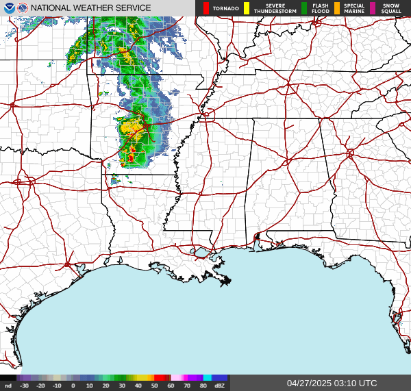
It is a rainy day in the Tennessee Valley with a good bit of fog. At 5 PM the visibility is down to 6 miles in Cullman and actually the same in Huntsville. Our High in Cullman today was 55, and the Low has been 46 so far; we might go lower than that before midnight tonight. So really the Low temperature remains to be seen for one of these strange days where there is a front moving slowly through the state. It's been a breezy day too, winds mainly out of the East/Northeast, gusts between 10-20 miles per hour at times. Huntsville has had a High of 54 and Low of 44 (so far) today. No point in mentioning a ton of sites when the temperature trends are this haphazard.


That's ultra scientific language, so don't quote me on that.


Tomorrow is going to be another wet one. There's more ultra-scientific jargon for ya'.


Seriously though, that front is going to lift back into Tennessee and Kentucky tomorrow, and we'll let other parts of the country worry about their snow and/or ice. We've got our own issues here. The main risk with this tomorrow is flash flooding or river flooding, even if instances of that stay kind of isolated. We haven't been put under a Flood Watch like we get with some systems. But as noted/linked to above in the notes section, parts of Northwest Alabama are under a Flood Warning because small streams are expected to have issues through tomorrow.
The less likely threat is for some thunderstorms that could make it to severe limits tomorrow.


And that threat looks marginal for North Alabama. It's one of those borderline situations where we might have one or two storms get out of hand, the main threat being damaging winds, not really concerned for large hail with this. Chance of a tornado somewhere is minimal up this way, a little more worth paying attention to as you get down toward Birmingham and points South into Southern Alabama back into Southern Mississippi. They also have a better chance at organized lines of storms capable of producing straight-line wind damage with tomorrow's system.
But I personally think for Cullman and surrounding areas, the threat for severe thunderstorms will be minimal tomorrow, not even as much as these official maps from SPC are outlooking, because we're looking to start the day about 50 degrees and then only warm to about the 60-63 degree range. And today's forecast busted as far as temperatures; it didn't get as warm as expected. If you can call 60 degrees warm. We only got to 55. So will allow for a low risk of an isolated stronger storm tomorrow, but I just doubt it for North Alabama. My personal opinion is that that stuff will probably stay in Central/Southern parts of the state. I don't think we'll have enough unstable air up this way.
If we get anything up here, it'll be isolated, but then, that's what the Marginal Risk category means, and those low probabilities like 5% for damaging wind or 2% for a tornado.


And actually far Northern Alabama is not included in the Marginal Risk, places like Florence, Athens, or up into Tennessee. It barely clips Huntsville, Decatur, and Scottsboro. If this risk were trimmed back farther to the South the next time they update it, that would not surprise me.
So tomorrow looks like another soaker, heavy rain expected, maybe an isolated thunderstorm or two, and we can't completely rule out something reaching severe limits, at least South of the TN River. (Even though I'm skeptical with the air this cool and stable.) High should be about 60-63, Low tonight near 50.


And there you can see it on a simple, colorful weather map instead of the raw model data.
We'll have a good North/Northwest breeze, so it'll feel colder than what those numbers let you know, at least at times during the day, despite plenty of sunshine.


On Friday that strong High pressure system will be working its way up toward New England, and down here we'll stay sunny and dry. Temperature guidance is now showing such good radiational cooling Thursday night that we're looking at upper 20's for Friday morning and then only warming to the upper 50's. So pretty seasonable.


On Saturday it looks like our next storm system is more serious. For one thing, it could dump enough rain to aggravate our existing flooding problems, wherever they've already happened from tomorrow (Wednesday). But this has the look of a system that could produce some organized severe weather. At the moment, it looks like we'll have a High of 70 or so and a Low in the mid-to-upper-40's. And unlike the last warm snap we had here in February, this time it looks like the ingredients may come together for some severe thunderstorms, might even be looking at some supercells out ahead of the main front and whatever squall line it produces. It's four days away, and we really need to wait until Thursday, after tomorrow's front is gone, to try to iron out the details. But we can peek a little.


Between 6-9 PM Saturday evening the GFS is currently forecasting enough of a combination of unstable air and wind shear to support severe thunderstorms in North Alabama and at least parts of Southern Middle Tennessee.

It looks like unstable air could be the limiting factor, with CAPE values only about 500 j/kg and Lifted Indices about -3. But combine that with such a dynamic front coming in, the surface Low pressure system oriented in a favorable position to bring our region severe weather, plus Helicity values at or above 300 m^2/s^2 even at the lowest kilometer of the atmosphere . . . and we're looking at potential for severe thunderstorms capable of producing damaging winds, large hail, and at least isolated tornadoes in the region. We've got curved hodographs and good directional wind shear as well as speed shear. This may not be a really high threat of severe weather, but it's really too soon to make that call, since it's four days away. This looks like one I'd definitely respect, and it covers a fairly broad area in our region.

Basically the whole state of Alabama and Mississippi are includes in this basic risk for severe weather. Southern, Middle, and part of Eastern Tennessee are includes. It clips Arkansas, the Southeast corner, and includes the bulk of Louisiana. So Saturday looks like a busy weather day for several NWS offices.
Over the next few days leading up to the event, some parts of this may need to be upgraded to the 30% enhanced risk level, wherever the threat for supercell thunderstorms looks greatest. Those tend to produce the more damaging storms that hang together a long time. But any severe weather threat is worth taking seriously. And this one looks much more likely to be organized than anything we might see tomorrow.

All the counties of North Alabama and the bordering counties of Southern Middle Tennessee are included in this basic 15% risk for severe weather Saturday. And this will include some tornado potential as well as the threat for damaging straight-line winds in storms and the threat for large hail.


Sunday we'll be clearing out. But especially if the storms don't start until after dark on Saturday, then we could certainly have at least isolated showers still going on in the early morning. Overall it'll be a day of decreasing clouds, High of 50 or so, Low near 40. This is a strong cold front.


We'll really feel its effects on Monday, which is George Washington's birthday. A lot of people call him the father of our country. I think the main debate on that is that Benjamin Franklin is on a $100 bill, and people like carrying around his face more than Washington's since he's on a $1 bill. Ah well, so much for my being all patriotic for a moment. Both those guys had better sense than any politicians I've seen make any progress any time lately. (Send hate mail here if you're so inclined.) It's going to be a cold one, sunny skies but only making it up to the mid-40's. And we'll start the day down near 20 degrees. So as much as I hate to sound full of hazards for this forecast, it's one of those nights/mornings (Sunday night into Monday morning) that you'll want to protect your pipes and more importantly, make sure everybody can stay warm enough, whether that's a neighbor who doesn't always have the best heat, or a dog that needs to be kept warm out in his house out by the fence. Or honestly, even if I still had outdoor pets, I'd bring them in for just the one cold night, nights like that. To be on the safe side. And if I knew anybody without proper heat, I'd let them stay the night. As long as it wasn't somebody trying to steal from me or cause other mischief . . . then I guess I'd just let 'em freeze out there. (Again, I did let you know where to send the hate mail if you think I've got it coming.)


Looks like we stay mostly sunny Tuesday with temperatures rebounding into the mid-50's for Highs and upper 20's for Lows.

Rainfall totals of 3-5 inches will be common over the next seven days around these parts.
Working on writing up a review of severe weather/tornado safety rules on the fly. Just in case we do have any problems tomorrow, no harm in getting it done tonight. More important for people to be prepared for Saturday, especially if any of our problems come Saturday night.


No comments:
Post a Comment