

FORECAST:
Thursday (High 50, Low 40): Gradually decreasing clouds. Cold and breezy.
Valentine's Day (High 56, Low 27): Mostly sunny. Seasonably cold.
Saturday (High 70, Low 46): Thunderstorms likely, especially at night. Some storms may be severe.
EXTENDED OUTLOOK:
Sunday (High 55, Low 44): Mostly cloudy with a 30% chance of showers.
President's Day (High 46, Low 21): Sunny.
Tuesday (High 53, Low 26): Mostly sunny.
Wednesday (High 49, Low 32): Partly to mostly cloudy with a 40% chance of showers.
PRONÓSTICO:
Jueves (Máxima 50, Mínima 40): Nubes que disminuyen gradualmente. Frío y ventoso.
Día de San Valentín (Máxima 56, Mínima 27): Mayormente soleado. Frío estacional.
Sábado (Máxima 70, Mínima 46): Tormentas eléctricas probables, especialmente por la noche. Algunas tormentas pueden ser severas.
PERSPECTIVA EXTENDIDA:
Domingo (Máxima 55, Mínima 44): Mayormente nublado con un 30 % de probabilidad de lluvias.
Día de los Presidentes (Máxima 46, Mínima 21): Soleado.
Martes (Máxima 53, Mínima 26): Mayormente soleado.
Miércoles (Máxima 49, Mínima 32): Parcialmente a mayormente nublado con un 40 % de probabilidad de lluvias.
NOTES:
It is a good time to review severe weather safety rules.
The next SKYWARN class is 6 PM Tuesday February 18 at the Space and Rocket Center. As always, these classes are free to the public, anyone interested in learning more about severe weather and public safety. And I just noticed, same night, same time, one is being held at Cullman City Hall. There are also online classes available to people who can't make it to one of the physical ones.
If you can make it to an in-person class, though, I'd strongly recommend it. The experience is usually a lot better. And for folks near Nashville, Severe Weather Awareness Day is being held Saturday February 22 at Trevecca University by the National Weather Service in Nashville, some folks in Emergency Management up that way, and several of the local broadcast meteorologists. Looks like Danielle Breezy and Lisa Spencer will be there along with a couple others. You do need to register for that one beforehand. As far as I know, all these spotter classes, you just show up. Or of course you register online if it's an online class.
DISCUSSION:

As expected, the Tennessee Valley region is covered up in a cool rain this afternoon.

Some of us, including Cullman and Walker Counties, went under a Flash Flood Watch at some point overnight. The only Flood Warnings in North Alabama are for Indian Creek in Madison County and for the Paint Rock River near Woodville affecting Madison, Marshall, and Jackson Counties. Well also the Flint River at Brownsboro is having some flooding issues today. I'd be careful driving around those bodies of water through tomorrow and just remember to never try to cross any water that covers a roadway. And really be careful anywhere in our area of North Alabama/Southern Middle Tennessee. If you see flood waters - turn around, don't drown.


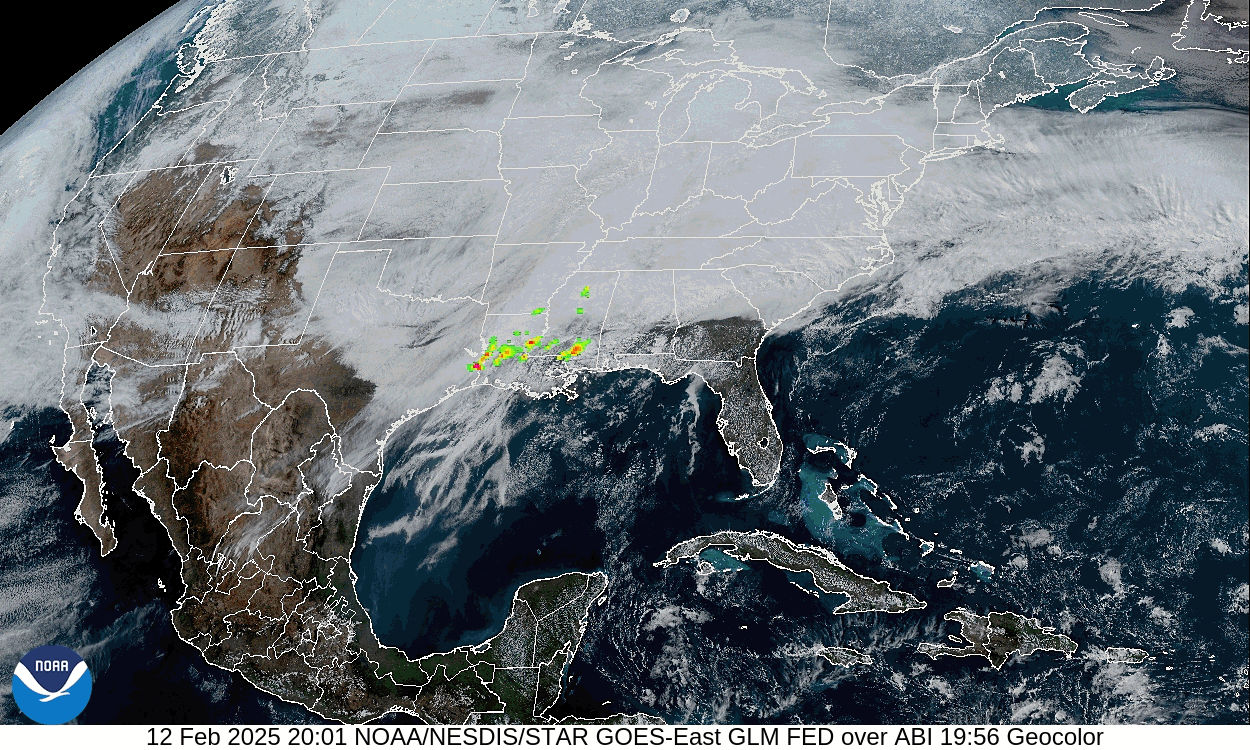
There has not been much lightning in North Alabama because the air has stayed relatively cool and stable. We are seeing an uptick in lightning in some thunderstorms in Northwest Walker County and Southern Winston County at the moment. But most of our thunderheads (see on visible satellite imagery) are down in South Alabama and actually more back in Southern Mississippi. Where you see temperatures up to 70 or warmer and dewpoints well up into the 60's. That unstable air makes a lot of difference. They've even had some storms go severe and show rotation, prompting some severe thunderstorm and tornado warnings down that way.


Our upper-level winds have shifted to the Southwest for the moment. And our front appears to have split into two stationary fronts for now. But the whole mess will finish moving through the area overnight.


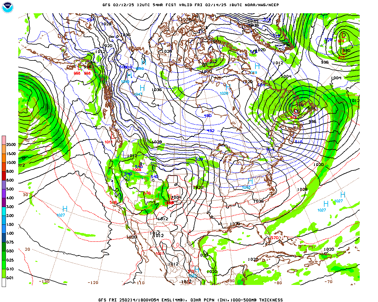
Which will look something like this on a standard, color-enhanced weather map. Looks like most of the snow will be out West of the Rockies tomorrow and most of the ice up in New England.

But before we look at tomorrow and beyond locally, let's take a look at the rest of today and tonight's severe weather potential. Most of it is going to stay South of the TN Valley counties, mainly along and South of Birmingham and Gadsden. And the worst of it will probably be even further South than that, affecting cities like Montgomery and stretching back into Southern Mississippi. That's where they had to issue an enhanced Level 3/5 risk for severe weather this evening/tonight.


There is a 30% chance of damaging thunderstorm winds in that area. The threat for large hail is marginal, about 5%.

And the tornado threat is substantial down there, about 10%. And notice the hatching of that broad area. That means there is a better chance of a tornado that stays on the ground a while and does fairly significant damage. So it's a serious threat for those people down there this evening and tonight.
Around here, we've got a marginal 5% chance of an isolated damaging wind event and a minimal 2% risk for an isolated tornado. Those risks extend about up to Huntsville.
As cool as it is, if we see anything like that, I'll be surprised.


Clouds will gradually decrease behind the front tomorrow, and it will stay breezy, the wind shifting back around to the Northwest at the surface, gusts up to about 20 mph at times. The High should be about 50, the Low tonight about 40.

Then that strong high pressure centered in Eastern parts of the Ohio Valley will bring us mostly sunny skies and a quick shot of cold air again on Friday. We'll start the day in the upper 20's and warm to about the mid-50's.


Saturday remains the day to watch, as we have another front coming our way and what appears to be a favorable track of the surface Low pressure system to support organized severe thunderstorms in our region, not just the Tennessee Valley but much of the Southeast overall.
Thunderstorms are likely on Saturday, and some may become severe. The High should be about 70 degrees after a morning Low in the mid-maybe-upper-40's. Temperatures will rebound in a hurry with this strong cold front. Of course Saturday/Saturday night we'll be on the warm side of it.


On Sunday we have a pretty standard disagreement between the American and European global models.

Where the ECMWF wants to drag the rain out of here a little more gradually than the GFS.
Looks like one of those messy days behind a cold front, probably clouds lingering a lot and temperatures hovering, but will estimate a High in the 50's and Low in the 40's with a good bit of cloud cover and about a 30% chance of lingering showers. Bumping it up from the 20% I was forecasting before because the European model might be onto something, solution sort of fits the pattern here.


Then on Monday, which is George Washington's Birthday, we'll be sunny with a High in the mid-40's, Low in the lower 20's. Some places may actually see 20 degrees or slightly lower, those colder pockets, I guess especially up in the mountains.


Then Tuesday looks mostly sunny with a High in the lower 50's, Low in the mid-to-upper-20's.


Then it looks like on Wednesday a Low pressure system in the GUFF (Gulf - practicing my Cajun dialect, or some kind of Louisiana dialect anyway) will cause moisture to overspread the Southeast and bring us some significant rain chances again. Will keep probability of precipitation at 40% for now, but it does look like rain, not cold enough for snow, starting the day in the lower 30's and warming to the upper 40's or maybe about 50. Looks like a cool rain day with even less chance of thunder than today.

We could see at least another 2-3 inches of average rainfall across much of the region over the next seven days.
MESOSCALE DISCUSSION:


This system on Saturday has the potential for organized severe weather, and it is now within the reach of the SREF. And it is making it look like a system with a lot of strong wind shear, even the low-level rotation we'd look for as a major ingredient in tornadoes being able to form. This is valid between 9 PM-12 AM Saturday night/Sunday morning.


In that same time frame, it looks like almost no unstable air will be available to work with, CAPE values staying below 500 joules/kilogram, which is usually considered the baseline for getting any severe thunderstorms. They may get some unstable air in Mississippi, but this guidance makes it look lacking around here.


Sometimes the models underestimate the instability, parameters like Convective Available Potential Energy (quick science lesson - that's what CAPE stands for), especially when it's still the cold season. We are not into March yet, when we'd more typically expect an organized severe weather setup. But even looking at dewpoints, you can see that in North Alabama, we are struggling to get to a 60 degree dewpoint temperature. So by any measure, if this guidance turns out to be reliable, we have a low instability/high wind shear setup. We usually see those in November or maybe December, and a lot of them bust, just producing rain and strong winds without any severe weather.


And now we'll look at the NAM. These models should give us more reliable data tomorrow. Today it's kind of dicey since it's at the end of how far out these models run (and they are mesoscale models, not global ones, much better in the short-term than once you get out to three days or more) and also because we're still dealing with this messy front bringing us the rain (and bringing South Alabama/Mississippi organized severe weather tonight, including a significant tornado threat) right now. Tomorrow after this front is past the area, and the models have the state of the atmosphere after this system to work with, at a more reliable time range, forecasts will be able to nail down more of the specific details of how this will likely unfold.
But for now, here is a look at the simulated radar, and the timing is similar, about 9 PM-12 AM Saturday night. And this is showing a squall line. Maybe an isolated supercell or two out ahead of it somewhere.

.png)
And it has a similar look to what the SREF did, where the instability just looks to be lacking around here.

.png)
While the wind energy is just about ideal for producing tornadoes if we did have the unstable air.

.png)
And we do need to pay attention to this: Dewpoints are forecast by the NAM to get up to 60 degrees or so in North Alabama, perhaps even into Southern Tennessee. This could be a sign that the models are currently underestimating the unstable air that will be available.
Even if that's the case, based on what we see right now, this looks like a low instability/high wind shear event, more like we'd see in about November than we'd see as we were getting into March. And those are dicey. Very minor details can make the difference between whether someone gets just some rain and gusty winds or something a lot worse. So all eyes will be on this trying to fine-tune the details of what parts of the Southeast will have specific threats over the next couple days leading up to this potential severe weather event.


Most of the Southeast is still under that basic 15% risk for severe thunderstorms on Saturday/Saturday night, but a good chunk of the region has been upgraded to an enhanced 30% risk area, where supercell thunderstorms are more likely to be able to form ahead of or within the squall line. This would be where the greatest tornado threat would be, although I doubt any part of our region will be totally immune to a tornado threat with this one, if we get any instability at all, and wind fields continue to look really strong with a lot of low-level shear. This synoptic setup just looks like a severe weather setup, even if we didn't dig into the details the mesoscale models are predicting. As of right now, the most likely areas to have that enhanced severe weather threat look like Central/Southern Mississippi, parts of Northern Louisiana, into much of West Central Alabama. In our neck of the woods, people in Walker, Winston, Marion, Fayette, and Lamar Counties need to keep an even closer eye on how this develops than the rest of us. You can see Tupelo, Mississippi is also in that hot zone where supercell thunderstorms look more likely to be able to develop. This enhanced threat area may be expanded North and East by tomorrow's outlook or Friday's. It's tough to predict two storm systems at once. Because the models are working with what the atmosphere is expected to be like tomorrow. Which has a margin of error. Once we see what the actual parameters are behind the front tomorrow, the models will initialize with better information. And it'll be easier to outline the specific areas that have the basic severe weather threat versus the enhanced threat.
Any severe weather threat is worth taking seriously. So please let people know. Saturday night is not a time most people are thinking about severe weather, especially in early February. Have your safety plan in place in case you need it, and encourage other people to be aware/prepared. We may have some problems out of this one.


No comments:
Post a Comment