FORECAST:
Sunday (High 55, Low 33): Partly to mostly cloudy during the day with an isolated shower or two possible. After dark, rain showers are likely, becoming breezy overnight.
Monday (High 64, Low 45): Rainy. Breezy.
Tuesday (High 63, Low 56): Rain likely. Breezy.
EXTENDED OUTLOOK:
Wednesday (High 44, Low 31): Mostly sunny.
Thursday (High 47, Low 24): Sunny.
Friday (High 51, Low 27): Mostly sunny.
Saturday (High 54, Low 32): Partly cloudy.
PRONÓSTICO:
Domingo (Máxima 55, Mínima 33): Parcialmente a mayormente nublado durante el día con una o dos lluvias aisladas posibles. Después del anochecer, es probable que haya lluvias, con viento durante la noche.
Lunes (Máxima 64, Mínima 45): Lluvioso. Ventoso.
Martes (Máxima 63, Mínima 56): Probable lluvia. Ventoso.
PERSPECTIVA EXTENDIDA:
Miércoles (Máxima 44, Mínima 31): Mayormente soleado.
Jueves (Máxima 47, Mínima 24): Soleado.
Viernes (Máxima 51, Mínima 27): Mayormente soleado.
Sábado (Máxima 54, Mínima 32): Parcialmente nublado.
NOTES:
Today is SKYWARN Spotter recognition day. So thanks to all of you who help us out with that training.
Our winters around here tend to be mild, but this one is not starting out that way, so here are some reminders from NOAA about being prepared for when it does get bitter.
And much of the Tennessee Valley remains in moderate to severe drought conditions. Which is why I said so much below that we're glad to have this rain coming in, early part of this coming week.
At 1:15 PM, skies are fair in Cullman. The temperature is 52 degrees. The dewpoint is 14 degrees, making the relative humidity 22%. Winds are from the South at 5 miles per hour. The pressure is 30.31 inches and falling slowly. The Low this morning was 21. Great merciful heavens, if I may quote the great Johnny Bravo, that is cold. We didn't waste any time getting into the Winter season this year.
It is also sunny in Jasper with a temperature of 52 degrees. The dewpoint-temp is 14, and their relative humidity is also 22%. Winds are variable at 3 mph. The pressure is 30.34 inches and falling slowly. The morning Low was 21 degrees there too.
It is sunny and 52 degrees in Haleyville. The dewpoint is 18, making the relative humidity 26%. Winds are Southwest at 5 mph. The pressure is 30.34 inches/1003.6 millibars and falling slowly. Their morning Low was 22.
We'll look at a couple more sites just to get the feel of how things are around the region.
It's sunny and 49 degrees in Huntsville, with a dewpoint of 10 degrees, making the relative humidity 21%. Winds are SW at 6 mph. Pressure is 30.32 inches/1027.2 millibars and falling slowly. The morning Low was 23 for the Rocket City.
And now for the Music City, Nashville is sunny and 51 degrees. The dewpoint is 12, making the relative humidity 21%. Winds are South at 9. The pressure is 30.27 inches/1025.5 millibars and falling slowly. Their Low this morning was 22 degrees.
So it's another cold but sunny day in the Tennessee Valley.
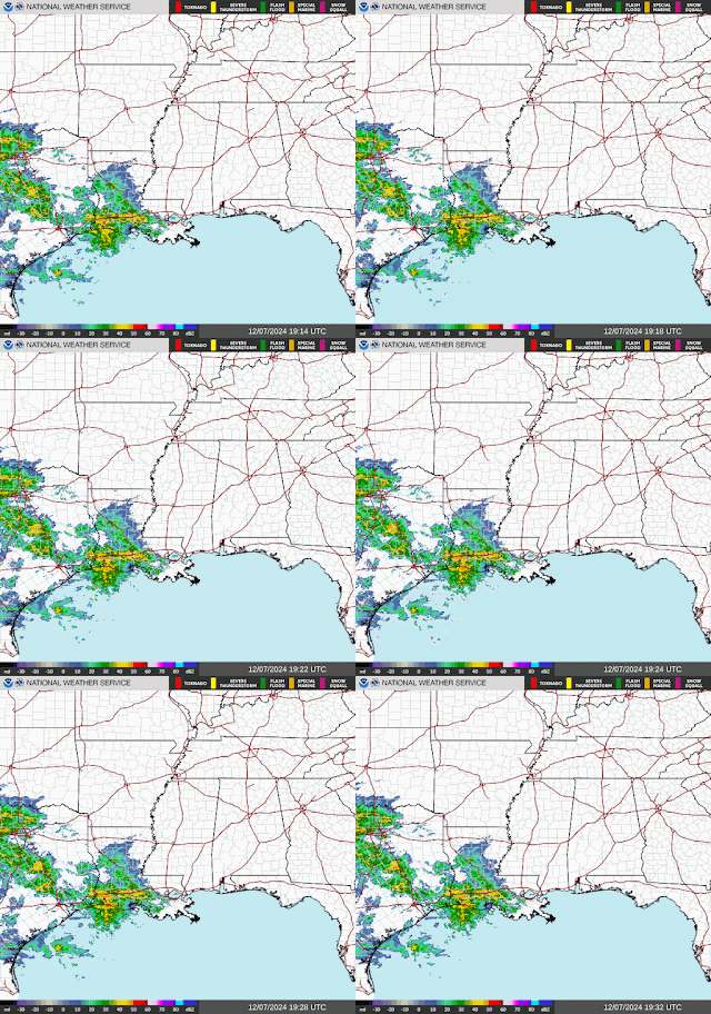
We have high pressure in place over Southern Mississippi and Alabama, keeping our skies sunny for now. But notice that low pressure system and quasi-stationary front off the South coast of Texas. That will bring us clouds this evening into tomorrow as it slowly moves to the Northeast.
So those clouds will spread from Southwest to Northeast starting this evening and tonight. We'll have some chance of rain tomorrow lasting through Monday. The main focus of this forecast is being able to pin down what rain chances we have and exactly when. It won't be as cold tonight because of the clouds moving in, plus plenty of southern wind flow out of the Gulf of Mexico as that front approaches.
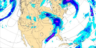
The ice and snow is staying about where you'd expect it to this time of year, close to the Canadian border and in places like New England or out in Colorado. This system is going to bring rain over the next couple days to a good chunk of the Eastern third of the country, up to Michigan and as far East as the Carolinas and Virginias. We definitely need the rain around here in the Southeast and Tennessee Valley.
Looks like tomorrow will mainly just be a day of increasing clouds. Most of the day should be dry. Most of the rain should come after dark, but remember, it does get dark early this time of year.
We'll be covered up in rain showers at Midnight between Sunday and Monday, and we may see widely scattered showers by tomorrow evening, by about 3-6 PM.
So overall partly to mostly cloudy skies tomorrow, could see widely scattered showers before dark, but most of the rain will come overnight and is expected to be widespread then. The High should be about 55, and the Low about 33 or 34.
The American GFS is showing some fairly rapid clearing on Monday with the front moving through quickly.
The slower European ECMWF solution looks more likely to be right here, more of an unsettled look. The European model has done a lot better even going back to when hurricane season was still going on.
Anyway tomorrow night is going to get breezy, and that will continue into Monday. The coverage of rain should be gradually decreasing throughout the day Monday, but at least before Noon or early afternoon, I'd keep rain chances in the "likely" category, over 60%. I'd put it at 100% tomorrow night into very early Monday morning. Should see a High in the mid-60's, Low in the mid-40's, and just a rainy, breezy day. The air will likely stay too stable for any thunderstorms, at least up this way, in North Alabama.
Then oddly enough, even the GFS, the model that wanted to get in such a hurry on Monday, is even picking up on the idea of a second surge of moisture before this front is through with us on Tuesday. Some of that second wave of rain will start Monday night, and then rain showers are likely throughout the day on Tuesday. It should be another breezy day, and we might see enough unstable air to support an isolated thunderstorm or two. But I think most of us will just get a cool rain, the rain we so badly need right now around here. High should be in the lower 60's, the Low in about the mid-50's.
Then Wednesday we clear out rapidly again with a strong shot of cold air behind this front. We'll be mostly sunny with a High in the lower-to-mid-40's. The Low should be down around 30 or so. Don't think we see any lingering showers, those should end Tuesday night. But we may have a northerly breeze at least in the early hours of Wednesday. And it is going to feel really cold again, closer to January temperatures. But it varies from one year to the next. And this time, we got really cold in a hurry. After much of the Fall was above average warmth.
Thursday that same basic pattern will bring us a sunny day with a High in the mid-to-upper-40's, a Low in probably the lower 20's, could be mid-20's for some places. But it's another below-freezing morning.
Then on Friday, the center of high pressure will be moving through New England, and our temperatures will moderate a little bit around here. Key words being "a little." We'll still see a High in the lower 50's, Low in the upper 20's.
Then on Saturday, a week from today, we've got another front moving through the Plains with the surface Low probably up around South Dakota. Around here I think we'll stay mostly sunny with a High in the mid-50's and a Low in the lower 30's.
And beyond that, the model guidance is just a big mess. I don't trust it enough to do a 10-day-outlook here. At some point we'll get another cold front, but the timing is really up in the air. Might mention increasing clouds on Saturday but not enough evidence to put even a minimal 20% rain chance in there.
Rainfall totals for this forecast period will average about one inch, with locally heavier amounts possible here and there. We do need the rain.
If you'd like to see these weather forecasts/updates more frequently, please consider dropping a dollar in my bucket at the link above. If there is enough interest, I've even toyed around with the idea of doing YouTube videos again like I did when going to school for this full-time. But for now . . . that's all, folks.


No comments:
Post a Comment