

FORECAST:
Wednesday (High 80, Low 50): Sunny. Mild.
Thursday (High 80, Low 51): Sunny. Mild.
Friday (High 78, Low 50): Mostly sunny. Mild.
EXTENDED OUTLOOK:
Saturday (High 79, Low 48): Sunny.
Sunday (High 81, Low 51): Mostly sunny.
Columbus Day (High 72, Low 52): Mostly sunny.
Tuesday (High 66, Low 44): Sunny.
BEACH FORECAST:
Wednesday (High 87, Low 65): Sunny and breezy. Hazardous rip currents.
Thursday (High 85, Low 63): Sunny and breezy. Hazardous rip currents.
Friday (High 81, Low 61): Sunny.
PRONÓSTICO:
Miércoles (Máxima 80, Mínima 50): Soleado. Templado.
Jueves (Máxima 80, Mínima 51): Soleado. Templado.
Viernes (Máxima 78, Mínima 50): Mayormente soleado. Templado.
PERSPECTIVA EXTENDIDA:
Sábado (Máxima 79, Mínima 48): Soleado.
Domingo (Máxima 81, Mínima 51): Mayormente soleado.
El Día de la Raza (Máxima 72, Mínima 52): Mayormente soleado.
Martes (Máxima 66, Mínima 44): Soleado.
PRONÓSTICO DE LA PLAYA:
Miércoles (Máxima 87, Mínima 65): Soleado y ventoso. Corrientes de resaca peligrosas.
Jueves (Máxima 85, Mínima 63): Soleado y ventoso. Corrientes de resaca peligrosas.
Viernes (Máxima 81, Mínima 61): Soleado.
NOTES:
Time has just about run out to evacuate in Florida, but in case it should help anyone, here is a page that appears reliable for keeping up with evacuation orders.
SKYWARN classes are being offered by the National Weather Service offices in Huntsville, Birmingham, and Nashville before we get into the month of November. These classes are free, and anyone with an interest in weather and/or public safety is strongly encouraged to take one, whether online or in person. A couple of the classes being offered by NWS Huntsville are specifically for people who are deaf or hard of hearing. Thanks to them for making that extra effort and even offering people a ride who need it.


It was a sunny and breezy day in the Tennessee Valley. The High in Cullman was 77, and the Low was 48. That is cooler than we've been in a while. Jasper saw a High of 79 and a Low of 46 today. Haleyville had a High of 77 and Low of 51. Fort Payne had a High of 80 and Low of 48. Decatur saw a High of 80 and Low of 51. Huntsville had a High of 82 and Low of 53. Muscle Shoals had a High of 80 and Low of 54. Tupelo had a High of 78 and Low of 50. Memphis had a High of 77 and Low of 55. And Nashville had a High of 77 and Low of 51 today.
So that cold front has finally cleared our region and is down in the Gulf of Mexico with Hurricane Milton, which of course, is what everyone's eyes are on worldwide, may turn out to be one of the most destructive hurricanes ever on record. And talk about luck, it is aiming for Central Florida, a place heavily populated that just isn't a place that's likely to do too well if they do take a direct hit from this thing, with its ferocious winds, flooding rains, and storm surge. The impacts may be catastrophic. Fortunately, it looks like a lot of people have taken the evacuation orders seriously this time, because of what happened recently with Hurricane Helene in a different part of Florida, in the Big Bend. That may mitigate the death toll with this one. Not that I'm trying to jinx it. Just trying some cautious optimism.


We are well away from this "divine wind" and on the dry side of it anyway. And tomorrow will be a calm, sunny day around here, with a High near 80, Low near 50.


The model consensus is good between the GFS, NAM, and ECMWF that Hurricane Milton will make landfall at or just South of Tampa. The timing has slowed down some, these graphics being valid at 1 AM Thursday CDT. So tomorrow night into Thursday morning looks like the time window for landfall.


Even the East Coast of Florida is under a Hurricane Warning for this, and some significant damage is possible even after it moves inland and crosses through the Peninsula. It's just that the West Coast is expected to get the worst of it because of the storm surge and also because any hurricane tends to be at its strongest right before it moves inland. But everybody in or near the path of this storm is in for a rough ride. This will likely be a historic hurricane with major damage.
Here on the home front, it looks like another dry day Thursday, sunshine, a High near 80 and Low of 50 or so again.


A shortwave trough will move through the region on Friday but with no rain, high pressure settling in strongly behind it. We will stay sunny, could see a few fair-weather clouds in passing, the High in the upper 70's, and starting the day, the morning Low, around 50 again.


Sunny again on Saturday, High in the upper 70's, few warmer pockets may see 80, the Low in the upper 40's, really dry air in place, great radiational cooling conditions at night.


Sunday we actually have a cold front dropping in. Let's get a better look at that on traditional weather maps, graciously provided by the Weather Prediction Center.
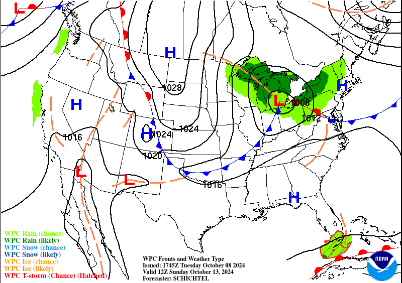

And you can see that front moving through here between Sunday and Monday.


Monday is when we should see the next shot of cooler air filtering in here. Looks like quite a contrast between Sunday and Monday, which is Columbus Day.
Sunday we'll start the day around 50 degrees and warm to about 80 or so, standard stuff in this pattern. But behind this reinforcing cold front (expected to be mostly or all dry), Monday looks like the High will drop to only about 70 or so degrees, the Low staying near 50.


But that is only the beginning of Fall coming in with a vengeance. Model Output Statistics (old-fashioned I know, but National Blend of Models data on NWS websites remains sloppy for now, far as I can see . . . so I use the old stuff that is easier to sort through) is showing a High on Tuesday in the mid-60's and a Low only in the mid-40's.


Of course the main weather story is Hurricane Milton.
Those two weak disturbances on the board are nothing to worry about around here, and neither is Hurricane Leslie, which is going to weaken, recurve in the Atlantic, and become post-tropical by this weekend.


Hurricane Milton is back up to a Category 5 on the Saffir-Simpson Wind Scale, with maximum sustained winds of 165 miles per hour. The minimum central pressure is 902 millibars/26.64 inches.
It has reintensified today, and one thing to notice is how much lightning there is in the eyewall. You see that with some of the worst hurricanes when they are really firing up over warm waters.
The winds of this thing may weaken some tomorrow before landfall, but I wouldn't count on that too much. And "weaken" here is a misleading term, because at the very least, we're expecting Category 3 winds at the time of landfall, which means somewhere in the range of 111-129 mph, sustained winds. Those kinds of winds combined with all the water in this hurricane . . . deadly combination. And in my opinion, we can't count on it "weakening" like that. It weakened for a while today and then strengthened again to this maximum strength we are seeing now. It's nitpicking too much to try to decide whether it will have winds consistent with a Category 3, 4, or 5 at the time of landfall. It is going to be a horrible storm, no matter how you slice it.
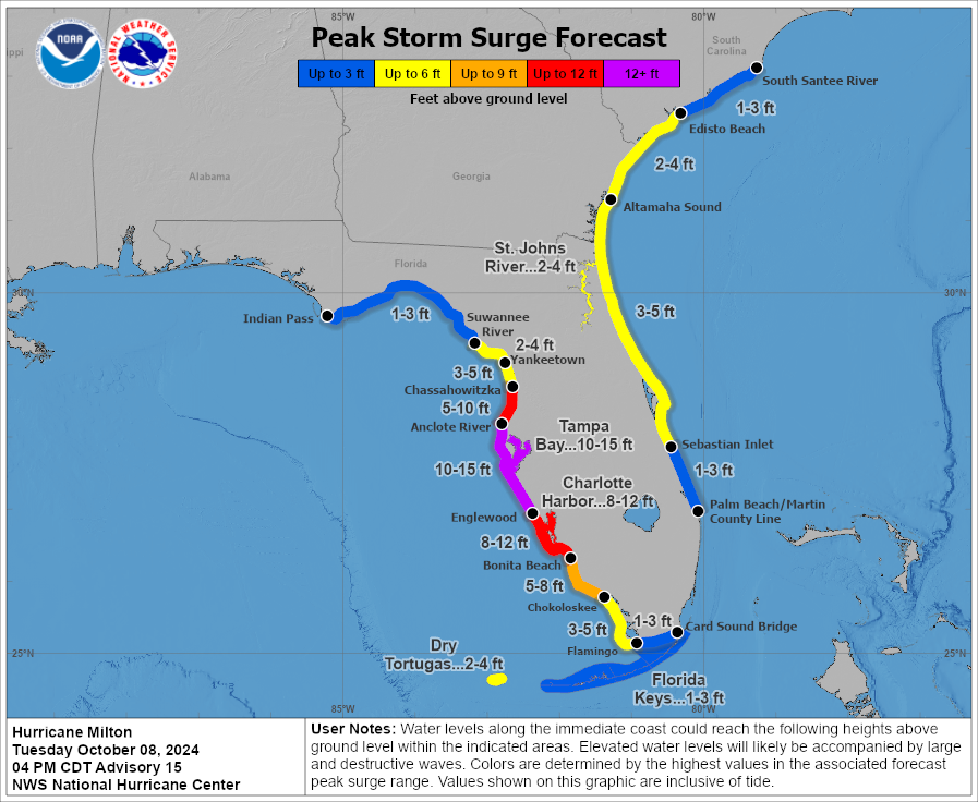

Much of the West Coast of the Florida Peninsula could have storm surge of up to 10-15 feet. So again, catastrophic impacts are a good possibility with this. You're not likely to see a hurricane any worse than this in your life. And the threat for flooding in Central Florida is looking high.

The Hurricane Warning is from Bonita Beach northward to Suwannee River, includes Tampa Bay; that's on the West Coast. On the East Coast, the Hurricane Warning is from the St. Lucie/Martin County Line northward to Ponte Vedra Beach. It basically has ended up including all of the Central Florida Peninsula. The rest of the Peninsula is under a Tropical Storm Warning, and in some areas, that overlaps with a Hurricane Watch. Many of these areas are also under a Storm Surge Warning or Watch. A Tropical Storm Watch extends all the way up through far Eastern parts of Georgia and South Carolina, just in case those folks experience tropical storm level impacts before all is said and done.
For people under the Hurricane Warning, the best case scenario is being able to evacuate, even if it's only tens of miles away, not hundreds of miles away. I hope before tomorrow morning, people are out of those areas that are going to be hardest hit. At least people in the Warning along the West Coast, I hope most or all of them were able to evacuate. Sometimes these things are tough to watch play out after chewing up all the technical meteorological data and trying to predict them. If this is not a worst-case scenario, it sure is close enough.
Maybe some people were not able to evacuate or decided it was too much trouble. So I refer those people to these reminders about how to ride out a hurricane. And also be aware that there are public shelters being offered to people who need them.
And fair warning, in or near the areas hit directly by this hurricane, power may go out for days or even weeks at a time. So even if you've done your best, this is bound to be some rough stuff. Some people who evacuated may have no home to go back to, or the home may be badly damaged. That's just the reality. But in a situation like this, we'll worry about property later. The main thing is PROTECTING LIFE.
And you can always luck out, even with a storm of this magnitude. But you have to be prepared for the worst.
Just about the only bit of comic relief I found about this sobering situation was that the rock band Deicide actually cancelled the rest of their current tour to go check on their families and property in their home state of Florida. I've heard that their singer, Glen Benton, is a smart, nice guy behind his persona. So I hope those guys can protect their kinfolks and themselves. Like I say, property is secondary in a situation like this. You can't always save it. Something like this, you make sure everybody is okay, before you worry about things that can be replaced. That story just made me laugh because that seemed like the final bit of proof of how serious this storm is, that even a legendary death metal band knows not to fart around with it.
This past weekend was the anniversary of when the weather lady in my family died at the age of 93, and maybe that's one reason the idea is fresh in my mind: You can't replace somebody's life. So that's my main hope with this storm, that people just take care of themselves and each other down there. It is inevitable that some property is going to be destroyed with this thing. We'll deal with that. But we had way too high a death toll from Hurricane Helene. And hopefully that can be mitigated with this Hurricane Milton. The forecasts and warnings have been excellent, and it sounds like most everyone knows how serious this is. If you are on the fence about evacuating in one of these evacuation zones, and can safely do so, I would strongly urge you to do so tonight. This is the last storm you want to fool around with. I would not be surprised if it's mentioned in history along with hurricanes like Katrina or Andrew. And conditions will begin to deteriorate tomorrow many hours before the actual landfall.

No rain around here any time soon, just tons of it associated with this hurricane getting ready to slam Florida.
The only impacts for places like Mobile or Pensacola, Panama City, are hazardous rip currents, like any time a hurricane comes nearby.
Stay safe down that way.


No comments:
Post a Comment