

Monday (High 81, Low 60): Mostly sunny and breezy. Patchy fog possible in the early morning.
Tuesday (High 77, Low 50): Sunny. Cool.
Wednesday (High 78, Low 52): Sunny. Cool.
Thursday (High 77, Low 51): Sunny.
Friday (High 76, Low 50): Sunny.
Saturday (High 76, Low 49): Sunny.
Sunday (High 77, Low 50): Sunny.
SKYWARN classes are being held before we get into the Fall severe weather season (usually the month of November for North Alabama into Southern Tennessee).


Our weather pattern is going to remain quiet around here. Hurricane Milton has formed in the Gulf of Mexico, and our neighbors in the Florida Peninsula are likely to have a rough time from that soon. But even that cold front you see to our North/Northwest is going to come through here dry, and just bring us some of those Fall temperatures a lot of us have been waiting on.
By the way, that guy I know whose air conditioner konked out yesterday got it fixed in a timely fashion, for any loyal readers who actually care about such things. The lady who told me about the situation calls him Pookie, but . . .eh . . . I refuse. I do like David Allan Coe, I just call him by his name. Which is not Milton . . . that's the hurricane's name.


So we'll see a Low of about 60 tonight, High of about 80 tomorrow, mostly sunny skies, some breezy times of day as that cold front comes through. Not expecting any rain with this one, just barely an increase in a few fair-weather clouds and some northerly wind gusts up to about 15 miles per hour. Could see some patchy fog tonight, but most or all of it should be gone by daybreak.
Then on Tuesday, looking at sunny skies, High of about 77-78, Low near 50.


And let's take a closer look at Wednesday, since that's the day Hurricane Milton is expected to make landfall on the Florida Peninsula. This is the raw GFS output valid at 1 PM CDT.

The NAM looks similar, slightly faster timing.

And the ECMWF looks the fastest of the main models I check for just routine weather around here. It's a close call exactly where that thing ends up along the West Coast of the Florida Peninsula. It's been looking like it was headed right for Tampa Bay, but these latest trends make it look like the track could go slightly farther South. That's why when we get to the official National Hurricane Center track, you'll notice that cone of uncertainty is still broad at this point. I don't believe any Hurricane Watches or Warnings have been issued for Florida yet. They are under a Flash Flood Watch in Central and Southern Florida, for potential of 5-10 inches of total rainfall through Thursday, with isolated amounts up to 15 inches possible. The Hurricane Watches/Warnings will probably come out tomorrow morning. They're probably just waiting to really pinpoint who needs to be under what.
Around here on the dry side of the hurricane and far away from its impacts, we'll be sunny with a High in the upper 70's, Low in the lower 50's. Model guidance is trending upward on the temperatures again. For a while it looked like several mornings in the upper 40's, but now it's looking more like lower 50's. It's still cooler than we've been in a while.
For our extended period around here, high pressure will remain firmly in control of our local weather.
The weather Thursday looks about the same as Wednesday's. The only thing, Friday through the weekend, as the high pressure becomes even more firmly entrenched over the region, the air will be even drier, and we'll see Lows closer to 50, could dip into upper 40's here and there, the Highs sometimes in the mid-70's instead of upper 70's. Skies staying sunny.

Hurricanes Kirk and Leslie pose no immediate threat to land. Kirk will go post-tropical before affecting Northern Europe. Leslie is aiming vaguely in the direction of Bermuda but is expected to weaken to a tropical storm through this week. For now we're just going to focus on Hurricane Milton.


Right now, this is a small hurricane that is barely to the point of showing a clearly defined eye. But it already has winds sustained at 85 mph. The central pressure is 981 millibars, 28.97 inches. And a Hurricane Watch is in effect (issued by the Government of Mexico) from Celestun to Cabo Catoche. A Tropical Storm Warning is in effect from Celestun to Cancun. So over the next couple days, people on that Northern part of the Yucatan Peninsula may be dealing with some issues even while this hurricane is in its earlier stages.
Before it makes it to the Florida Peninsula, it is expected to become a major hurricane, and the estimates of wind speeds are now up to 120-145 mph. Here is a handy page to keep a check on for which parts of Florida are under evacuation orders as this thing unfolds.
This will probably be at least a "Category 3" storm at the time of landfall, and could easily be even stronger than that. So if you get an evacuation order for this storm, I'd move farther inland away from the main impacts, even if the order is voluntary, giving a choice whether or not to ride it out. I personally would not, the way this hurricane is looking. Too much of a gamble. Storms like this, sometimes even the news people down there getting their hair blown around covering it run into some trouble. And I just wouldn't if I didn't have to. This is another serious situation.
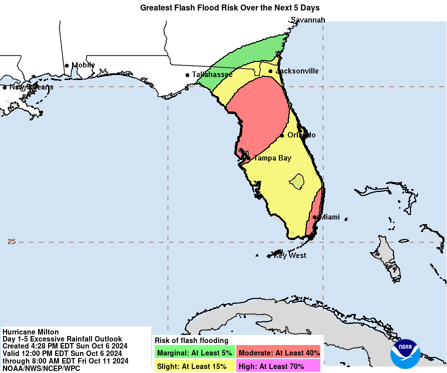
And of course part of the impact is going to be from flooding issues. Looks like that will especially be a concern along and North of Tampa Bay. Some of the Big Bend may have additional flooding issues, unfortunately, when they just got round one of that with Hurricane Helene. This Hurricane Milton is expected to grow to a large, major hurricane capable of very significant impacts by the time it hits land. The impacts for the hardest-hit areas around the eyewall could potentially be catastrophic. And even out in those spiral bands on the East/Northeast side of this thing as it moves inland, there will be a threat for flash flooding, damaging winds, and isolated tornadoes. So anybody close to the path of this does need to take this one seriously. Technically you should any hurricane, but this looks like it could be very significant. It is intensifying rapidly already, and it just looks like a rough ride for especially the West Coast of the Florida Peninsula.

No rain expected around here for the next seven days, but of course, people in the path of this hurricane are going to get soaked. And we may see fairly significant issues with flash flooding, considering that they are already getting rain in that area and will continue to until the hurricane comes through. I hope people can evacuate who are close to the direct path of this one. Maybe people just affected by the spiral bands a little farther North can afford to shelter in place, but I'm going to let the local government officials decide that stuff. My only advice is that if you do get an evacuation order, I would follow it. This looks like serious business.


No comments:
Post a Comment