


Hurricane watches or warnings will likely be required for the West Coast of Florida by some time this evening or tonight. Landfall is probably very late Tuesday night or very early Wednesday morning. If along and North of Tampa Bay along the Peninsula, you are really encouraged to take this threat seriously. Expected to be a major hurricane.
000
WTNT34 KNHC 061748
TCPAT4
BULLETIN
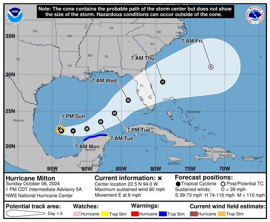
Hurricane Milton Intermediate Advisory Number 5A
NWS National Hurricane Center Miami FL AL142024
100 PM CDT Sun Oct 06 2024
...AIR FORCE HURRICANE HUNTERS FIND MILTON RAPIDLY INTENSIFYING
INTO A HURRICANE...
SUMMARY OF 100 PM CDT...1800 UTC...INFORMATION
----------------------------------------------
LOCATION...22.5N 94.0W
ABOUT 290 MI...465 KM WNW OF PROGRESO MEXICO
ABOUT 815 MI...1310 KM WSW OF TAMPA FLORIDA
MAXIMUM SUSTAINED WINDS...80 MPH...130 KM/H
PRESENT MOVEMENT...E OR 100 DEGREES AT 6 MPH...9 KM/H
MINIMUM CENTRAL PRESSURE...988 MB...29.18 INCHES
WATCHES AND WARNINGS
--------------------
CHANGES WITH THIS ADVISORY:
None.
SUMMARY OF WATCHES AND WARNINGS IN EFFECT:
A Tropical Storm Warning is in effect for...
* Celestun to Cabo Catoche
A Tropical Storm Watch is in effect for...
* East of Cabo Catoche to Cancun
A Tropical Storm Warning means that tropical storm conditions are
expected somewhere within the warning area within 36 hours.
A Tropical Storm Watch means that tropical storm conditions are
possible within the watch area, generally within 48 hours.
Interests in the remainder of the Yucatan peninsula of Mexico, the
Florida Peninsula, the Florida Keys, and the northwestern Bahamas
should monitor the progress of this system.
Hurricane and Storm Surge Watches could be required for
portions of Florida late today.
For storm information specific to your area, please monitor
products issued by your national meteorological service.
DISCUSSION AND OUTLOOK
----------------------
At 100 PM CDT (1800 UTC), the center of Hurricane Milton was
located by an Air Force Reserve Hurricane Hunter aircraft near
latitude 22.5 North, longitude 94.0 West. Milton is moving toward
the east near 6 mph (9 km/h), and this general motion is expected
today. An eastward to east-northeastward motion is forecast on
Monday, followed by a faster northeastward motion on Tuesday and
Wednesday. On the forecast track, Milton is forecast to move north
of the Yucatan Peninsula and to move across the Gulf of Mexico and
approach the west coast of the Florida Peninsula by midweek.
Maximum sustained winds have increased to near 80 mph (130 km/h)
with higher gusts. Milton is forecast to rapidly intensify during
the next couple of days and become a major hurricane on Monday.
Hurricane-force winds extend outward up to 20 miles (30 km) from
the center and tropical-storm-force winds extend outward up to 80
miles (130 km) from the center.
The estimated minimum central pressure is 988 mb (29.18 inches)
based on Air Force dropsonde data.
HAZARDS AFFECTING LAND
----------------------
Key Messages for Hurricane Milton can be found in the Tropical
Cyclone Discussion under AWIPS header MIATCDAT4 and WMO header
WTNT44 KNHC and on the web at hurricanes.gov/text/MIATCDAT4.shtml
RAINFALL: Rainfall amounts of 5 to 8 inches, with localized totals
up to 12 inches, are expected across portions of the Florida
Peninsula and the Keys through Wednesday night. This rainfall brings
the risk of locally considerable flash, urban, and areal flooding,
along with widespread minor to moderate river flooding with major
flooding possible.
Milton will also produce rainfall totals of 2 to 4 inches across
portions of the northern Yucatan Peninsula.
For a complete depiction of forecast rainfall associated with
Hurricane Milton, please see the National Weather Service Storm
Total Rainfall Graphic, available at
hurricanes.gov/graphics_at4.shtml?rainqpf and the Flash Flood Risk
graphic at hurricanes.gov/graphics_at4.shtml?ero.
WIND: Tropical storm conditions are expected in the Tropical Storm
Warning area in the Yucatan Peninsula Monday night and Tuesday and
possible in the watch area on Tuesday.
SURF: Swells generated by the system are affecting the coast
of the southwestern Gulf of Mexico today. These swells are expected
to spread northward and eastward along much of the Gulf Coast by
early next week, and could cause life-threatening surf and rip
current conditions. Minor coastal flooding could also occur along
the northern coast of the Yucatan Peninsula from large swells.
Please consult products from your local weather office.
NEXT ADVISORY
-------------
Next complete advisory at 400 PM CDT.
$$
Forecaster Blake
583
WTNT44 KNHC 061458
TCDAT4
Tropical Storm Milton Discussion Number 5
NWS National Hurricane Center Miami FL AL142024
1000 AM CDT Sun Oct 06 2024
Satellite and aircraft data indicate that Milton is strengthening.
A large burst of convection is occurring in the northern semicircle
of the storm, with lots of expanding outflow. The last fix from the
NOAA Hurricane Hunter aircraft showed a pressure down to 991 mb
with maximum 500m low-level winds of about 65 kt. These winds
reduce down to the surface to about 55 kt, and this value will be
the initial intensity.
The fixes from the aircraft indicate that Milton is south of the
previously anticipated and has been moving east-southeastward or
105/5 kt. Milton is forecast to move a little south of due east
today in westerly flow from a shortwave trough over the northern
Gulf of Mexico. The storm should then turn northeastward and
accelerate on Tuesday and Wednesday toward the Florida Peninsula.
As a result of this re-positioning and initial motion, there's been
a southward change to most of the guidance this morning. The new
NHC forecast is adjusted south of the previous one, especially early
on, and further southward adjustments could be required if the
guidance trend continues. The Mexican government has issued a
Tropical Storm Warning for the north coast of the Yucatan Peninsula
as a result of the forecast change. It should be noted that the
average NHC track error at day 3 is around 100 miles, and users
should not focus on the exact track.
The NOAA Hurricane Hunter crew reported that an eyewall has formed
on the last center fix, suggesting that this system is ready to
intensify quickly. Given the track over the very deep warm waters
of the Gulf of Mexico and little shear for the next couple of days,
rapid intensification is explicitly forecast, and the new NHC
prediction could still be conservative over the central Gulf of
Mexico. The biggest question actually seems to be the intensity as
Milton approaches Florida, with much of the guidance showing a
notable increase in shear. While some weakening is anticipated,
the shear could help transition Milton to be a large hurricane at
landfall, with impacts spread out over a big area. Regardless of
the details, there is increasing confidence that a powerful
hurricane with life-threatening hazards will be affecting portions
of the Florida west coast around the middle of this week. Residents
there should closely monitor this system and listen to local
officials.
Key Messages:
1. Milton is forecast to quickly intensify while it moves eastward
to northeastward across the Gulf of Mexico and be a major hurricane
when it reaches the west coast of the Florida Peninsula mid week.
Users are reminded to not focus on the details of the forecast as
there remains significant uncertainty in the eventual track and
intensity of Milton.
2. While it is too soon to specify the exact magnitude and location
of the greatest impacts, there is an increasing risk of
life-threatening storm surge and damaging winds for portions of the
west coast of the Florida Peninsula beginning Tuesday night or early
Wednesday. Storm Surge and Hurricane Watches could be issued later
today or tonight. Residents in the Florida Peninsula should follow
any advice given by local officials and check back for updates to
the forecast.
3. Areas of heavy rainfall will impact portions of Florida today
and Monday well ahead of Milton, with heavy rainfall more directly
related to the system expected later on Tuesday through Wednesday
night. This rainfall will bring the risk of flash, urban, and areal
flooding, along with the potential of moderate to major river
flooding.
4. Tropical storm conditions are expected beginning Monday across
portions of the northern Yucatan Peninsula of Mexico where a
Tropical Storm Warning is in effect.
FORECAST POSITIONS AND MAX WINDS
INIT 06/1500Z 22.4N 94.4W 55 KT 65 MPH
12H 07/0000Z 22.2N 93.7W 65 KT 75 MPH
24H 07/1200Z 22.2N 92.0W 85 KT 100 MPH
36H 08/0000Z 22.5N 90.0W 100 KT 115 MPH
48H 08/1200Z 23.5N 88.0W 110 KT 125 MPH
60H 09/0000Z 24.7N 86.0W 110 KT 125 MPH
72H 09/1200Z 26.5N 84.0W 105 KT 120 MPH
96H 10/1200Z 29.0N 79.0W 75 KT 85 MPH
120H 11/1200Z 31.0N 72.0W 55 KT 65 MPH...POST-TROP/EXTRATROP
$$
Forecaster Blake
445
WTNT54 KNHC 061459
TDSAT4
Tormenta Tropical Milton Discusión Número 5
Centro Nacional de Huracanes del SNM Miami FL AL142024
1000 AM CDT domingo 06 de octubre de 2024
Los datos de satélite y de aviones indican que Milton se está
fortaleciendo. Una gran ráfaga de convección está ocurriendo en el
semicírculo norte de la tormenta, con mucho de flujo de salida en
expansión. La última solución del avión Cazahuracán de la NOAA
mostró una presión de hasta 991 mb con vientos máximos de 500m de
bajo nivel de aproximadamente 65 kt. Estos vientos se reducen a la
superficie a aproximadamente 55 kt, y este valor será la intensidad
inicial.
Las correcciones desde el avión indican que Milton está al sur de lo
anticipado previamente y se ha estado moviendo hacia el este-sureste
o 105/5 kt. Se pronostica que Milton se moverá un poco al sur del
este hoy en un flujo oeste desde una depresión de onda corta sobre
el norte del Golfo de México. La tormenta debe luego girar hacia el
noreste y acelerar el martes y el miércoles hacia la Península de
Florida. Como resultado de este reposicionamiento y movimiento
inicial, ha habido un cambio hacia el sur a la mayoría de la guía
esta mañana. El nuevo pronóstico del CNH se ajusta al sur del
anterior, especialmente desde el principio, y podrían requerirse más
ajustes hacia el sur si la tendencia de la guía continúa. El
gobierno mexicano ha emitido un Aviso de Tormenta Tropical para la
costa norte de la Península de Yucatán como resultado del cambio de
pronóstico. Debe tenerse en cuenta que el error promedio de la
trayectoria del NHC el día 3 es alrededor de 100 millas, y los
usuarios no deben enfocarse en la trayectoria exacta.
La tripulación del Cazahuracán de la NOAA informó que se ha formado
una pared del ojo en el último arreglo central, lo que sugiere que
este sistema está listo para intensificarse rápidamente. Dada la
trayectoria sobre las aguas muy cálidas del Golfo de México y la
poca cizalladura para los próximos dos días, se pronostica
explícitamente una intensificación rápida, y la nueva predicción del
CNH todavía podría ser conservadora sobre el centro del Golfo de
México. La pregunta más grande en realidad parece ser la intensidad
a medida que Milton se acerca a Florida, con gran parte de la guía
que muestra un aumento notable en la cizalladura. Si bien se
anticipa algún debilitamiento, la cizalladura podría ayudar a la
transición de Milton para ser un gran huracán al tocar tierra, con
impactos esparcidos sobre un área grande. Independientemente de los
detalles, hay una confianza cada vez mayor en que un poderoso
huracán con peligros que amenazan la vida estará afectando porciones
de la costa oeste de Florida alrededor de la mitad de esta semana.
Los residentes allí deben monitorear de cerca este sistema y
escuchar a los funcionarios locales.
Mensajes Clave:
1. Se pronostica que Milton se intensificará rápidamente mientras se
mueve hacia el este a noreste a través del Golfo de México y será un
huracán mayor cuando alcance la costa oeste de la Península de
Florida a mediados de la semana. Se recuerda a los usuarios que no
se enfoquen en los detalles del pronóstico, ya que permanece una
incertidumbre significativa en la eventual trayectoria e intensidad
de Milton.
2. Si bien es demasiado pronto para especificar la magnitud exacta y
ubicación de los mayores impactos, hay un riesgo creciente de
marejada ciclónica que amenazan la vida y vientos destructivos para
porciones de la costa oeste de la Península de Florida a partir del
martes por la noche o temprano el miércoles. Las Vigilancias de
Marejada Ciclónica y de Huracán podrían emitirse más tarde hoy o
esta noche. Los residentes en la Península de Florida deben seguir
cualquier consejo dado por los funcionarios locales y verificar de
nuevo para actualizaciones del pronóstico.
3. Áreas de fuertes lluvias afectarán porciones de Florida hoy y el
lunes bien por delante de Milton, con fuertes lluvias más
directamente relacionadas con el sistema se espera más tarde el
martes hasta el miércoles por la noche.Esta lluvia traerá el riesgo
de inundaciones repentinas, urbanas y áreas, junto con el potencial
de inundaciones de moderadas a mayores
4. Se esperan condiciones de tormenta tropical a partir del lunes a
través de porciones de la Península de Yucatán de México donde un
Aviso de Tormenta Tropical está en efecto.
POSICIONES DE PRONÓSTICO Y VIENTOS MÁXIMOS
INIT 06/1500Z 22.4N 94.4W 55 KT 65 MPH
12H 07/00Z 22.2N 93.7W 65 KT 75 MPH
24H 07/1200Z 22.2N 92.0W 85 KT 100 MPH
36H 08/00Z 22.5N 90.0W 100 KT 115 MPH
48H 08/1200Z 23.5N 88.0W 110 KT 125 MPH
60H 09/00Z 24.7N 86.0W 110 KT 125 MPH
72H 09/1200Z 26.5N 84.0W 105 KT 120 MPH
96H 10/1200Z 29.0N 79.0W 75 KT 85 MPH
120H 11/1200Z 31.0N 72.0W 55 KT 65 MPH...POST-TROP/EXTRATROP
$$
Pronosticador Blake
*** Este producto ha sido procesado automáticamente utilizando un
programa de traducción y puede contener omisiones y errores. El
Servicio Nacional de Meteorología no puede garantizar la precisión
del texto convertido. De haber alguna duda, el texto en inglés es
siempre la versión autorizada. ***
560
WTCA44 KNHC 061750
TASAT4
BOLETÍN
Huracán Milton Advertencia Intermedia Número 5A
Centro Nacional de Huracanes del SNM Miami FL AL142024
100 PM CDT domingo 06 de octubre de 2024
...LOS CAZADORES DE HURACANES DE LA FUERZA AÉREA ENCUENTRAN MILTON
INTENSIFICÁNDOSE RÁPIDAMENTE EN UN HURACÁN....
RESUMEN DE 100 PM CDT...1800 UTC...INFORMACIÓN
----------------------------------------------
UBICACIÓN...22.5N 94.0W
ALREDEDOR 290 MI...465 KM ONO DE PROGRESO MÉXICO
ALREDEDOR 815 MI...1310 KM WSW DE TAMPA FLORIDA
VIENTOS MÁXIMOS SOSTENIDOS...80 MPH...130 KM/H
MOVIMIENTO ACTUAL...E O 100 GRADOS A 6 MPH...9 KM/H
PRESIÓN CENTRAL MÍNIMA...988 MB...29.18 PULGADAS
VIGILANCIAS Y AVISOS
--------------------
CAMBIOS CON ESTA ADVERTENCIA:
Ninguno.
RESUMEN DE VIGILANCIAS Y AVISOS EN EFECTO:
Un Aviso de Tormenta Tropical está en efecto para...
* Celestun a Cabo Catoche
Una Vigilancia de Tormenta Tropical está en efecto para...
* Al este de Cabo Catoche a Cancún
Un Aviso de Tormenta Tropical significa que se esperan condiciones
de tormenta tropical en algún lugar dentro del área de aviso dentro
de 36 horas.
Una Vigilancia de Tormenta Tropical significa que son posibles las
condiciones de tormenta tropical dentro del área de vigilancia,
generalmente dentro de 48 horas.
Intereses en el resto de la península de Yucatán de México, la
Península de Florida, los Cayos de Florida y el noroeste de Bahamas
deben monitorear el progreso de este sistema.
Podrían requerirse Vigilancias de Marejada Ciclónica para porciones
de Florida tarde hoy.
Para información de la tormenta específica en su área, por favor
monitoree los productos emitidos por su servicio meteorológico
nacional.
DISCUSIÓN Y PERSPECTIVAS
----------------------
A las 100 PM CDT (1800 UTC), el centro del Huracán Milton fue
localizado por un avión Cazahuracán de la Reserva de la Fuerza Aérea
cerca de la latitud 22.5 Norte, longitud 94.0 Oeste. Milton se está
moviendo hacia el este cerca de 6 mph (9 km/h), y se espera este
movimiento general hoy. Se pronostica un movimiento hacia el este a
este-noreste el lunes, seguido de un movimiento hacia el noreste más
rápido el martes y el miércoles. En la trayectoria de pronóstico, se
pronostica que Milton se moverá al norte de la Península de Yucatán
y se moverá a través del Golfo de México y se acercará a la costa
oeste de la Península de Florida para mediados de semana.
Los vientos máximos sostenidos han aumentado a cerca de 80 mph (130
km/h) con ráfagas más fuertes. Se pronostica que Milton se
intensificará rápidamente durante los próximos dos días y se
convertirá en un huracán mayor el lunes.
Vientos con fuerza de huracán se extienden hacia fuera hasta 20
millas (30 km) desde el centro y vientos con fuerza de tormenta
tropical se extienden hacia fuera hasta 80 millas (130 km) desde el
centro.
La presión central mínima estimada es de 988 mb (29.18 pulgadas)
basada en los datos de sonda de la Fuerza Aérea.
PELIGROS AFECTANDO TIERRA
----------------------
Mensajes clave para el Huracán Milton se pueden encontrar en el
Tropical
Ciclón Discusión bajo el encabezado de AWIPS MIATCDAT4 y el
encabezado de la OMM WTNT44 KNHC y en la web en
hurricanes.gov/text/MIATCDAT4.shtml
LLUVIA: Se esperan cantidades de lluvia de 5 a 8 pulgadas, con
totales localizados de hasta 12 pulgadas, a través de porciones de
la Península de Florida y los Cayos hasta el miércoles por la
noche.Esta lluvia trae el riesgo de inundaciones localmente
considerables repentinas, urbanas y áreas, junto con inundaciones
generalizadas de menores a moderadas del río con posibles
inundaciones mayores.
Milton también producirá totales de lluvia de 2 a 4 pulgadas a
través de porciones de la Península de Yucatán norte.
Para una representación completa del pronóstico de lluvia associada
con el Huracán Milton, por favor vea el Gráfico de Lluvia Total de
Tormenta del Servicio Nacional de Meteorología, disponible en
hurricanes.gov/graphics_at4.shtml?rainqpf y el gráfico de Riesgo de
Inundaciones Repentinas en hurricanes.gov/graphics_at4.shtml? ero.
VIENTO: Se esperan condiciones de tormenta tropical en el área de
Aviso de Tormenta Tropical en la Península de Yucatán el lunes por
la noche y el martes y posible en el área de vigilancia el martes.
OLEAJE: Marejadas generadas por el sistema están afectando la costa
del suroeste del Golfo de México hoy. Se espera que estas marejadas
se extiendan hacia el norte y hacia el este a lo largo de gran parte
de la Costa del Golfo para principios de la próxima semana, y
podrían causar condiciones de oleaje y corrientes marinas que
amenazan la vida. Inundaciones costeras menores también podrían
ocurrir a lo largo de la costa norte de la Península de Yucatán
desde grandes marejadas. Por favor consulte los productos de su
oficina meteorológica local.
PRÓXIMA ADVERTENCIA
-------------
Próxima advertencia completa a las 400 PM CDT.
$$
Pronosticador Blake
*** Este producto ha sido procesado automáticamente utilizando un
programa de traducción y puede contener omisiones y errores. El
Servicio Nacional de Meteorología no puede garantizar la precisión
del texto convertido. De haber alguna duda, el texto en inglés es
siempre la versión autorizada. ***


No comments:
Post a Comment