

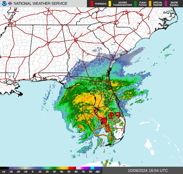


Landfall is imminent by some time tonight. The impacts are likely to be very significant, with devastating levels of damage possible. I think everybody knows that by now. Glad to see it being taken so seriously, I guess because of the recent impacts of Hurricane Helene. Governor DeSantis appears to have been on top of it, and Governor Ivey from here in Alabama is already prepared to offer Florida some help as it is needed later. Some of the effects of Hurricane Milton are already being felt in the Florida Peninsula, where a Tornado Watch is in effect through today and tonight. And you can see the hurricane clearly on radar above. There are several Tornado Warnings already as those rain bands move in.
I hope nobody is trying to ride out this hurricane in a mobile home down there anyway. But basically if you get a Tornado Warning, you need to get into a sturdy house or other strong building that's properly anchored to the ground, and get into the lowest, most central room of that building. And that can be a hallway. Definitely stay away from windows. Tornadoes that happen in the outer bands of a hurricane tend to happen quickly, so you might only have a minute or two to get to that safe spot in your home. Some of the places at risk for tornadoes with this are not going to get hurricane-level impacts. So if you're in one of the places only expecting tropical storm impacts but under the Tornado Watch, then this applies to you more than people under the Hurricane Warning. Because they are going to have to be hunkering down the whole time, if they did not evacuate. But if all you're getting are gusty winds and heavy rains for a long time . . . somebody could get surprised by one of these isolated tornadoes.

And here's a closer look at the hurricane and those low-topped supercells trying to produce tornadoes in its rain bands, the radar from Tampa Bay. These storms are beautiful to look at from a distance, and they are fascinating. But I don't envy anybody who's stuck down there in the path of it, I'll put it that way.
Inside the eye of Hurricane #Milton earlier today on @NOAA WP-3D Orion #NOAA43 "Miss Piggy." These missions collect data to help improve forecasts and support hurricane research.
— NOAA Aircraft Operations Center (@NOAA_HurrHunter) October 9, 2024
Visit @NHC_Atlantic and https://t.co/3phpgKNx0q for the latest forecasts/advisories.
Visit… pic.twitter.com/bgecJN0UDA
3:18 PM - Instead of bingeing on disaster details, I thought I'd share this really cool video of some pilots in the eye of Hurricane Milton. Can you imagine how thrilling that would be? And it helps all of us in the long run, gives more data to study.
By the way, if you find hurricanes interesting and are not afraid to try a science book, check out Divine Wind by Kerry Emanuel. It's one of those where he makes the heavy scientific stuff easy to understand and also just brings it down to a human level too, how fascinating these storms are, but how devastating they can also be. It takes a special kind of writer to be able to give good solid science in terms the average person can understand. I remember checking a Carl Sagan book out of the library when I was in college and being amazed at how accessible he made astrophysics. When just the word almost gave me a headache, like no, I could never understand that stuff. Books like that are great.
There have been several tornadoes confirmed in Florida, mainly South Florida, already from the rain bands of Hurricane Milton. And there will likely be several more. Everything forecasters have warned of for days now, we were not just blowing the wind around. This is one of those major hurricanes that people will remember. I guess the tornado videos are kind of cool too, but there are so many of them.
Anyway, it's on. Landfall tonight. Probably around Tampa Bay. Sarasota may also get a lot of the worst of this one.
Oh and I saw the idiot trying to ride the hurricane out in his boat, comparing it to Noah's Ark. I think the cops finally talked him into going to a shelter.
4:18 PM - Speaking of idiots though, sometimes I like it when Mother Nature gets even with people.
Going to work on a forecast . . .
000
WTNT64 KNHC 091700
TCUAT4
Hurricane Milton Tropical Cyclone Update
NWS National Hurricane Center Miami FL AL142024
100 PM EDT Wed Oct 09 2024
...TROPICAL-STORM-FORCE WINDS JUST OFFSHORE THE WEST COAST OF
FLORIDA...
...100 PM EDT POSITION UPDATE...
Milton is currently moving north-northeastward or 030/15 kt. A turn
towards the northeast is anticipated with a slower forward speed
later this evening.
Tropical-storm-force winds are just offshore and now is the time to
stay inside and away from windows. Listen for updates and be ready
in case you lose electrical power. Keep a battery-powered radio,
charged cell phone and flashlight handy.
The next update will be with the intermediate advisory at 200 PM EDT
(1800 UTC).
SUMMARY OF 100 PM EDT...1700 UTC...INFORMATION
-----------------------------------------------
LOCATION...26.2N 84.2W
ABOUT 145 MI...235 KM W OF FT. MYERS FLORIDA
ABOUT 160 MI...260 KM SW OF TAMPA FLORIDA
MAXIMUM SUSTAINED WINDS...145 MPH...230 KM/H
PRESENT MOVEMENT...NE OR 35 DEGREES AT 17 MPH...28 KM/H
MINIMUM CENTRAL PRESSURE...935 MB...27.61 INCHES
$$
Forecaster Kelly
382
WTNT34 KNHC 091456
TCPAT4
BULLETIN
Hurricane Milton Advisory Number 18
NWS National Hurricane Center Miami FL AL142024
1100 AM EDT Wed Oct 09 2024
...TORNADIC SUPERCELLS FROM MILTON BEGINNING TO SWEEP ACROSS THE
SOUTHERN FLORIDA PENINSULA...
...THE TIME TO PREPARE, INCLUDING EVACUATE IF TOLD DO SO, IS
QUICKLY COMING TO AN END ALONG THE FLORIDA WEST COAST...
SUMMARY OF 1100 AM EDT...1500 UTC...INFORMATION
-----------------------------------------------
LOCATION...25.8N 84.3W
ABOUT 160 MI...255 KM WSW OF FT. MYERS FLORIDA
ABOUT 190 MI...305 KM SW OF TAMPA FLORIDA
MAXIMUM SUSTAINED WINDS...145 MPH...230 KM/H
PRESENT MOVEMENT...NE OR 35 DEGREES AT 17 MPH...28 KM/H
MINIMUM CENTRAL PRESSURE...931 MB...27.50 INCHES
WATCHES AND WARNINGS
--------------------
CHANGES WITH THIS ADVISORY:
None.
SUMMARY OF WATCHES AND WARNINGS IN EFFECT:
A Storm Surge Warning is in effect for...
* Florida west coast from Flamingo northward to Yankeetown,
including Charlotte Harbor and Tampa Bay
* Sebastian Inlet Florida to Altamaha Sound Georgia, including the
St. Johns River
A Hurricane Warning is in effect for...
* Florida west coast from Bonita Beach northward to Suwannee River,
including Tampa Bay
* Florida east coast from the St. Lucie/Martin County Line northward
to Ponte Vedra Beach
A Storm Surge Watch is in effect for...
* North of Altamaha Sound Georgia to Edisto Beach South Carolina
A Hurricane Watch is in effect for...
* Dry Tortugas
* Lake Okeechobee
* Florida west coast from Chokoloskee to south of Bonita Beach
* Florida east coast north of Ponte Vedra Beach to the mouth of the
St. Marys River
* Florida east coast from the St. Lucie/Martin County Line to the
Palm Beach/Martin County Line
A Tropical Storm Warning is in effect for...
* Florida Keys, including Dry Tortugas and Florida Bay
* Lake Okeechobee
* Florida west coast from Flamingo to south of Bonita Beach
* Florida west coast from north of Suwanee River to Indian Pass
* Florida east coast south of the St. Lucie/Martin County Line to
Flamingo
* North of Ponte Vedra Beach Florida to the Savannah River
* Extreme northwestern Bahamas, including Grand Bahama Island, the
Abacos, and Bimini
A Tropical Storm Watch is in effect for...
* North of the Savannah River to South Santee River South
Carolina
A Storm Surge Warning means there is a danger of life-threatening
inundation, from rising water moving inland from the coastline,
during the next 36 hours in the indicated locations. For a
depiction of areas at risk, please see the National Weather
Service Storm Surge Watch/Warning Graphic, available at
hurricanes.gov. This is a life-threatening situation. Persons
located within these areas should take all necessary actions to
protect life and property from rising water and the potential for
other dangerous conditions. Promptly follow evacuation and other
instructions from local officials.
A Hurricane Warning means that hurricane conditions are expected
somewhere within the warning area. A warning is typically issued
36 hours before the anticipated first occurrence of
tropical-storm-force winds, conditions that make outside
preparations difficult or dangerous. Preparations to protect life
and property should be rushed to completion.
A Tropical Storm Warning means that tropical storm conditions are
expected somewhere within the warning area within 36 hours.
A Storm Surge Watch means there is a possibility of life-
threatening inundation, from rising water moving inland from the
coastline, in the indicated locations during the next 48 hours.
For a depiction of areas at risk, please see the National Weather
Service Storm Surge Watch/Warning Graphic, available at
hurricanes.gov.
A Hurricane Watch means that hurricane conditions are possible
within the watch area. A watch is typically issued 48 hours
before the anticipated first occurrence of tropical-storm-force
winds, conditions that make outside preparations difficult or
dangerous.
A Tropical Storm Watch means that tropical storm conditions are
possible within the watch area, generally within 48 hours.
For storm information specific to your area in the United
States, including possible inland watches and warnings, please
monitor products issued by your local National Weather Service
forecast office. For storm information specific to your area
outside of the United States, please monitor products issued by
your national meteorological service.
DISCUSSION AND OUTLOOK
----------------------
At 1100 AM EDT (1500 UTC), the center of Hurricane Milton was
located near latitude 25.8 North, longitude 84.3 West. Milton is
moving toward the northeast near 17 mph (28 km/h). A northeastward
motion with some decrease in forward speed is expected through this
evening. A turn toward the east-northeast and east is expected on
Thursday and Friday. On the forecast track, the center of Milton
will move across the eastern Gulf of Mexico today, make landfall
along the west-central coast of Florida tonight, and move off the
east coast of Florida over the western Atlantic Ocean on Thursday.
Maximum sustained winds are near 145 mph (230 km/h) with higher
gusts. Milton is a category 4 hurricane on the Saffir-Simpson
Hurricane Wind Scale. Milton is expected to remain an extremely
dangerous major hurricane when it reaches the west-central coast of
Florida tonight, and remain at hurricane strength while it moves
across the Florida peninsula through Thursday. Gradual weakening
is forecast while Milton moves eastward over the western Atlantic,
and it is likely to become an extratropical storm by early Friday.
Hurricane-force winds extend outward up to 35 miles (55 km) from the
center and tropical-storm-force winds extend outward up to 175 miles
(280 km). A NOAA saildrone (SD-1083) located approximately 80 miles
northeast of the center recently reported a sustained wind of 44 mph
(71 km/h) with a gust of 57 mph (91 km/h).
The minimum central pressure based on Air Force Reserve Hurricane
Hunter data is 931 mb (27.50 inches).
HAZARDS AFFECTING LAND
----------------------
Key Messages for Milton can be found in the Tropical Cyclone
Discussion under AWIPS header MIATCDAT4 and WMO header WTNT44 KNHC
and on the web at hurricanes.gov/text/MIATCDAT4.shtml
STORM SURGE: The combination of a dangerous storm surge and the
tide will cause normally dry areas near the coast to be flooded by
rising waters moving inland from the shoreline. The water could
reach the following heights above ground somewhere in the indicated
areas if the peak surge occurs at the time of high tide...
Anna Maria Island, FL to Boca Grande, FL...10-15 ft
Anclote River, FL to Anna Maria Island, FL...8-12 ft
Tampa Bay...8-12 ft
Boca Grande, FL to Bonita Beach, FL...8-12 ft
Charlotte Harbor...8-12 ft
Bonita Beach, FL to Chokoloskee, FL...5-8 ft
Aripeka, FL to Anclote River, FL...3-5 ft
Chokoloskee, FL to Flamingo, FL...3-5 ft
Sebastian Inlet, FL to Altamaha Sound, GA...3-5 ft
Altamaha Sound, GA to Edisto Beach, SC...2-4 ft
Yankeetown, FL to Aripeka, FL...2-4 ft
Dry Tortugas...2-4 ft
St. Johns River...2-4 ft
The deepest water will occur along the immediate coast near and to
the south of the landfall location, where the surge will be
accompanied by large and dangerous waves. Surge-related flooding
depends on the relative timing of the surge and the tidal cycle,
and can vary greatly over short distances. For information
specific to your area, please see products issued by your local
National Weather Service forecast office.
For a complete depiction of areas at risk of storm surge
inundation, please see the National Weather Service Peak Storm
Surge Graphic, available at
hurricanes.gov/graphics_at4.shtml?peakSurge.
RAINFALL: Rainfall amounts of 6 to 12 inches, with localized totals
up to 18 inches, are expected across central to northern portions of
the Florida Peninsula through Thursday. This rainfall brings the
risk of catastrophic and life-threatening flash and urban flooding,
along with moderate to major river flooding.
For a complete depiction of forecast rainfall associated with
Hurricane Milton, please see the National Weather Service Storm
Total Rainfall Graphic, available at
hurricanes.gov/graphics_at4.shtml?rainqpf and the Flash Flood Risk
graphic at hurricanes.gov/graphics_at4.shtml?ero.
WIND: Hurricane conditions are expected in the hurricane warning
area across Florida beginning this evening through Thursday morning
and are possible in the hurricane watch area on Thursday. Tropical
storm conditions are expected to begin in the warning area on the
west coast of Florida in a few hours, spreading across the peninsula
and reaching the east coast tonight. Tropical storm conditions are
expected to begin in the warning area along the Georgia coast on
Thursday.
Tropical storm conditions are expected in portions of the
northwestern Bahamas on Thursday.
Tropical storm conditions are possible within the watch area
on the South Carolina coast on Thursday.
TORNADOES: Several tornadoes are likely today and tonight across
parts of central and southern Florida.
SURF: Swells generated by Milton are expected to continue to affect
much of the Gulf Coast and will increase along the southeastern U.S.
coast during the next day or two. These swells are likely to cause
life-threatening surf and rip current conditions. Please consult
products from your local weather office.
NEXT ADVISORY
-------------
Next intermediate advisory at 200 PM EDT.
Next complete advisory at 500 PM EDT.
$$
Forecaster Berg
000
WTNT24 KNHC 091455
TCMAT4
HURRICANE MILTON FORECAST/ADVISORY NUMBER 18
NWS NATIONAL HURRICANE CENTER MIAMI FL AL142024
1500 UTC WED OCT 09 2024
HURRICANE CENTER LOCATED NEAR 25.8N 84.3W AT 09/1500Z
POSITION ACCURATE WITHIN 10 NM
PRESENT MOVEMENT TOWARD THE NORTHEAST OR 35 DEGREES AT 15 KT
ESTIMATED MINIMUM CENTRAL PRESSURE 931 MB
MAX SUSTAINED WINDS 125 KT WITH GUSTS TO 150 KT.
64 KT....... 30NE 30SE 30SW 25NW.
50 KT....... 50NE 50SE 50SW 40NW.
34 KT.......140NE 120SE 130SW 150NW.
12 FT SEAS..150NE 180SE 360SW 360NW.
WINDS AND SEAS VARY GREATLY IN EACH QUADRANT. RADII IN NAUTICAL
MILES ARE THE LARGEST RADII EXPECTED ANYWHERE IN THAT QUADRANT.
REPEAT...CENTER LOCATED NEAR 25.8N 84.3W AT 09/1500Z
AT 09/1200Z CENTER WAS LOCATED NEAR 25.0N 84.8W
FORECAST VALID 10/0000Z 27.0N 83.0W
MAX WIND 110 KT...GUSTS 135 KT.
64 KT... 30NE 30SE 30SW 30NW.
50 KT... 60NE 50SE 50SW 100NW.
34 KT...240NE 130SE 130SW 180NW.
FORECAST VALID 10/1200Z 28.0N 81.1W...INLAND
MAX WIND 75 KT...GUSTS 90 KT.
64 KT... 25NE 25SE 25SW 30NW.
50 KT... 70NE 50SE 50SW 60NW.
34 KT...240NE 140SE 130SW 170NW.
FORECAST VALID 11/0000Z 28.7N 78.3W...OVER WATER
MAX WIND 65 KT...GUSTS 80 KT.
64 KT... 20NE 20SE 0SW 30NW.
50 KT... 90NE 40SE 50SW 90NW.
34 KT...240NE 140SE 140SW 220NW.
FORECAST VALID 11/1200Z 29.1N 75.1W...POST-TROP/EXTRATROP
MAX WIND 55 KT...GUSTS 65 KT.
50 KT... 90NE 30SE 30SW 90NW.
34 KT...280NE 120SE 140SW 150NW.
FORECAST VALID 12/0000Z 29.3N 72.0W...POST-TROP/EXTRATROP
MAX WIND 50 KT...GUSTS 60 KT.
50 KT... 30NE 30SE 30SW 90NW.
34 KT...180NE 80SE 120SW 150NW.
FORECAST VALID 12/1200Z 29.9N 68.9W...POST-TROP/EXTRATROP
MAX WIND 45 KT...GUSTS 55 KT.
34 KT... 90NE 90SE 110SW 100NW.
EXTENDED OUTLOOK. NOTE...ERRORS FOR TRACK HAVE AVERAGED NEAR 125 NM
ON DAY 4 AND 175 NM ON DAY 5...AND FOR INTENSITY NEAR 15 KT EACH DAY
OUTLOOK VALID 13/1200Z 31.4N 62.2W...POST-TROP/EXTRATROP
MAX WIND 35 KT...GUSTS 45 KT.
34 KT... 50NE 60SE 80SW 50NW.
OUTLOOK VALID 14/1200Z 32.8N 55.9W...POST-TROP/EXTRATROP
MAX WIND 30 KT...GUSTS 40 KT.
REQUEST FOR 3 HOURLY SHIP REPORTS WITHIN 300 MILES OF 25.8N 84.3W
INTERMEDIATE PUBLIC ADVISORY...WTNT34 KNHC/MIATCPAT4...AT 09/1800Z
NEXT ADVISORY AT 09/2100Z
$$
FORECASTER BERG
000
WTNT44 KNHC 091456
TCDAT4
Hurricane Milton Discussion Number 18
NWS National Hurricane Center Miami FL AL142024
1100 AM EDT Wed Oct 09 2024
Milton's structure has begun to change due to the onset of strong
southwesterly shear, which UW-CIMSS is analyzing to be 30-35 kt.
The cloud canopy has become more asymmetric with dry air
infiltrating the western side of the circulation, and the eye has
also become cloud filled. The NOAA and Air Force Reserve
Hurricane Hunters observed that the eye is open to the south, and a
very recent dropsonde indicates that the minimum pressure is up to
931 mb. Milton's intensity is therefore set at 125 kt on this
advisory.
Deep-layer shear is expected to increase further today and this
evening, and continued weakening is anticipated. However, since
Milton only has another 12 hours or so over water, it is expected
to still be a major hurricane when it makes landfall tonight. The
NHC intensity forecast lies between the statistical-dynamical models
and the consensus aids at 12 hours, meaning that Milton is likely
to be a category 3 or 4 strength at landfall. A slow decay in the
winds is expected after landfall, but Milton is anticipated to move
off the east coast of Florida on Thursday still as a hurricane. On
another note, Milton is expected to begin interacting with a front
later this evening, which is likely to cause the wind field to
expand on the hurricane's northwestern side. This will likely
cause very strong, gusty winds to occur even to the north of where
Milton makes landfall.
Milton is moving quickly toward the northeast (035/15 kt). The
track models insist that the hurricane will continue to move
northeastward but slow down through the rest of today, with a turn
toward the east-northeast occurring overnight. The NHC track
forecast maintains continuity with the previous predictions, lying
near the northern boundary of the guidance envelope and close to
where the raw model fields bring the center onshore.
We would like to emphasize that Milton's exact landfall location is
not possible to predict even at this time, particularly if the
hurricane wobbles during the day and into this evening. Even at
12-24 hours, NHC's track forecasts can be off by an average of 20-30
nm. Since storm surge forecasts are highly sensitive to the exact
track, this means that the realized storm surge heights across the
Tampa Bay region and south may vary widely, and there will likely be
a noticeable gradient of surge heights to the north of the landfall
location. However, the risk of devastating storm surge still exists
across much of the west-central and southwest coast of Florida given
the size of the storm and the uncertainties in exactly where
landfall will occur.
Finally, damaging winds, life-threatening storm surge, and heavy
rainfall will extend well outside the forecast cone. This is a very
serious situation and residents in Florida should closely follow
orders from their local emergency management officials. Evacuations
and other preparations should be completed over the next couple of
hours.
Key Messages:
1. A large area of destructive storm surge, with highest inundations
of 10 ft or greater, is expected along a portion of the west-central
coast of the Florida Peninsula. If you are in the Storm Surge
Warning area, this is an extremely life-threatening situation. The
time to evacuate, if told to do so by local officials, is quickly
coming to a close.
2. Devastating hurricane-force winds are expected along portions of
the west coast of Florida, where a Hurricane Warning is in effect.
Milton is forecast to remain a hurricane while it crosses the
Florida Peninsula and life-threatening hurricane-force winds,
especially in gusts, are expected to spread inland across the
peninsula. Preparations to protect life and property, including
being ready for long-duration power outages, should be rushed to
completion.
3. Heavy rainfall across the Florida Peninsula through Thursday
brings the risk of catastrophic and life-threatening flash and urban
flooding along with moderate to major river flooding, especially in
areas where coastal and inland flooding combine to increase the
overall flood threat.
FORECAST POSITIONS AND MAX WINDS
INIT 09/1500Z 25.8N 84.3W 125 KT 145 MPH
12H 10/0000Z 27.0N 83.0W 110 KT 125 MPH
24H 10/1200Z 28.0N 81.1W 75 KT 85 MPH...INLAND
36H 11/0000Z 28.7N 78.3W 65 KT 75 MPH...OVER WATER
48H 11/1200Z 29.1N 75.1W 55 KT 65 MPH...POST-TROP/EXTRATROP
60H 12/0000Z 29.3N 72.0W 50 KT 60 MPH...POST-TROP/EXTRATROP
72H 12/1200Z 29.9N 68.9W 45 KT 50 MPH...POST-TROP/EXTRATROP
96H 13/1200Z 31.4N 62.2W 35 KT 40 MPH...POST-TROP/EXTRATROP
120H 14/1200Z 32.8N 55.9W 30 KT 35 MPH...POST-TROP/EXTRATROP
$$
Forecaster Berg
000
FONT14 KNHC 091456
PWSAT4
HURRICANE MILTON WIND SPEED PROBABILITIES NUMBER 18
NWS NATIONAL HURRICANE CENTER MIAMI FL AL142024
1500 UTC WED OCT 09 2024
AT 1500Z THE CENTER OF HURRICANE MILTON WAS LOCATED NEAR LATITUDE
25.8 NORTH...LONGITUDE 84.3 WEST WITH MAXIMUM SUSTAINED WINDS NEAR
125 KTS...145 MPH...230 KM/H.
Z INDICATES COORDINATED UNIVERSAL TIME (GREENWICH)
ATLANTIC STANDARD TIME (AST)...SUBTRACT 4 HOURS FROM Z TIME
EASTERN DAYLIGHT TIME (EDT)...SUBTRACT 4 HOURS FROM Z TIME
CENTRAL DAYLIGHT TIME (CDT)...SUBTRACT 5 HOURS FROM Z TIME
WIND SPEED PROBABILITY TABLE FOR SPECIFIC LOCATIONS
CHANCES OF SUSTAINED (1-MINUTE AVERAGE) WIND SPEEDS OF AT LEAST
...34 KT (39 MPH... 63 KM/H)...
...50 KT (58 MPH... 93 KM/H)...
...64 KT (74 MPH...119 KM/H)...
FOR LOCATIONS AND TIME PERIODS DURING THE NEXT 5 DAYS
PROBABILITIES FOR LOCATIONS ARE GIVEN AS OP(CP) WHERE
OP IS THE PROBABILITY OF THE EVENT BEGINNING DURING
AN INDIVIDUAL TIME PERIOD (ONSET PROBABILITY)
(CP) IS THE PROBABILITY OF THE EVENT OCCURRING BETWEEN
12Z WED AND THE FORECAST HOUR (CUMULATIVE PROBABILITY)
PROBABILITIES ARE GIVEN IN PERCENT
X INDICATES PROBABILITIES LESS THAN 1 PERCENT
PROBABILITIES FOR 34 KT AND 50 KT ARE SHOWN AT A GIVEN LOCATION WHEN
THE 5-DAY CUMULATIVE PROBABILITY IS AT LEAST 3 PERCENT.
PROBABILITIES FOR 34...50...64 KT SHOWN WHEN THE 5-DAY
64-KT CUMULATIVE PROBABILITY IS AT LEAST 1 PERCENT.
- - - - WIND SPEED PROBABILITIES FOR SELECTED LOCATIONS - - - -
FROM FROM FROM FROM FROM FROM FROM
TIME 12Z WED 00Z THU 12Z THU 00Z FRI 12Z FRI 12Z SAT 12Z SUN
PERIODS TO TO TO TO TO TO TO
00Z THU 12Z THU 00Z FRI 12Z FRI 12Z SAT 12Z SUN 12Z MON
FORECAST HOUR (12) (24) (36) (48) (72) (96) (120)
- - - - - - - - - - - - - - - - - - - - - - - - - - - - - - - - - -
LOCATION KT
CHARLESTON SC 34 X 2( 2) 2( 4) 1( 5) X( 5) X( 5) X( 5)
BEAUFORT MCAS 34 X 4( 4) 2( 6) X( 6) X( 6) X( 6) X( 6)
SAVANNAH GA 34 X 2( 2) 1( 3) X( 3) X( 3) X( 3) X( 3)
KINGS BAY GA 34 2 7( 9) 3(12) 1(13) X(13) X(13) X(13)
WAYCROSS GA 34 1 2( 3) X( 3) X( 3) X( 3) X( 3) X( 3)
MAYPORT NS FL 34 3 13(16) 4(20) X(20) X(20) X(20) X(20)
JACKSONVILLE 34 2 4( 6) 1( 7) X( 7) X( 7) X( 7) X( 7)
GAINESVILLE FL 34 4 18(22) 1(23) X(23) X(23) X(23) X(23)
DAYTONA BEACH 34 5 58(63) 6(69) X(69) X(69) X(69) X(69)
DAYTONA BEACH 50 X 5( 5) 2( 7) X( 7) X( 7) X( 7) X( 7)
THE VILLAGES 34 27 52(79) 1(80) X(80) X(80) X(80) X(80)
THE VILLAGES 50 1 6( 7) X( 7) X( 7) X( 7) X( 7) X( 7)
ORLANDO FL 34 30 65(95) 1(96) X(96) X(96) X(96) X(96)
ORLANDO FL 50 1 38(39) 4(43) X(43) X(43) X(43) X(43)
ORLANDO FL 64 X 7( 7) 1( 8) X( 8) X( 8) X( 8) X( 8)
COCOA BEACH FL 34 24 70(94) 3(97) X(97) X(97) X(97) X(97)
COCOA BEACH FL 50 2 50(52) 20(72) X(72) X(72) X(72) X(72)
COCOA BEACH FL 64 X 20(20) 17(37) X(37) X(37) X(37) X(37)
PATRICK AFB 34 24 70(94) 4(98) X(98) X(98) X(98) X(98)
PATRICK AFB 50 2 51(53) 20(73) X(73) X(73) X(73) X(73)
PATRICK AFB 64 X 21(21) 15(36) X(36) X(36) X(36) X(36)
FT PIERCE FL 34 22 65(87) 6(93) X(93) X(93) X(93) X(93)
FT PIERCE FL 50 2 29(31) 15(46) X(46) X(46) X(46) X(46)
FT PIERCE FL 64 X 9( 9) 7(16) X(16) X(16) X(16) X(16)
W PALM BEACH 34 15 48(63) 7(70) X(70) X(70) X(70) X(70)
W PALM BEACH 50 1 6( 7) 3(10) X(10) X(10) X(10) X(10)
W PALM BEACH 64 X 1( 1) 1( 2) X( 2) X( 2) X( 2) X( 2)
FT LAUDERDALE 34 11 33(44) 5(49) X(49) X(49) X(49) X(49)
FT LAUDERDALE 50 1 3( 4) X( 4) X( 4) X( 4) X( 4) X( 4)
MIAMI FL 34 4 7(11) 2(13) X(13) X(13) X(13) X(13)
HOMESTEAD ARB 34 3 5( 8) 2(10) X(10) X(10) X(10) X(10)
MARATHON FL 34 7 5(12) 2(14) X(14) X(14) X(14) X(14)
KEY WEST FL 34 9 4(13) 2(15) X(15) X(15) X(15) X(15)
NAPLES FL 34 86 4(90) 1(91) X(91) X(91) X(91) X(91)
NAPLES FL 50 10 6(16) X(16) X(16) X(16) X(16) X(16)
NAPLES FL 64 2 1( 3) X( 3) X( 3) X( 3) X( 3) X( 3)
FT MYERS FL 34 93 3(96) 1(97) X(97) X(97) X(97) X(97)
FT MYERS FL 50 15 16(31) X(31) X(31) X(31) X(31) X(31)
FT MYERS FL 64 3 7(10) X(10) X(10) X(10) X(10) X(10)
VENICE FL 34 99 X(99) X(99) X(99) X(99) X(99) X(99)
VENICE FL 50 84 12(96) 1(97) X(97) X(97) X(97) X(97)
VENICE FL 64 54 32(86) X(86) X(86) X(86) X(86) X(86)
TAMPA FL 34 97 3(99) X(99) X(99) X(99) X(99) X(99)
TAMPA FL 50 22 45(67) X(67) X(67) X(67) X(67) X(67)
TAMPA FL 64 6 30(36) X(36) X(36) X(36) X(36) X(36)
CEDAR KEY FL 34 49 20(69) 2(71) X(71) X(71) X(71) X(71)
CEDAR KEY FL 50 2 2( 4) X( 4) X( 4) X( 4) X( 4) X( 4)
TALLAHASSEE FL 34 2 1( 3) X( 3) X( 3) X( 3) X( 3) X( 3)
ST MARKS FL 34 2 1( 3) 1( 4) X( 4) X( 4) X( 4) X( 4)
APALACHICOLA 34 3 3( 6) X( 6) X( 6) X( 6) X( 6) X( 6)
GFMX 290N 850W 34 8 4(12) X(12) X(12) X(12) X(12) X(12)
PANAMA CITY FL 34 2 3( 5) X( 5) X( 5) X( 5) X( 5) X( 5)
ALBANY GA 34 1 2( 3) X( 3) X( 3) X( 3) X( 3) X( 3)
GFMX 290N 870W 34 2 1( 3) X( 3) X( 3) X( 3) X( 3) X( 3)
BERMUDA 34 X X( X) X( X) X( X) 1( 1) 8( 9) X( 9)
GRAND BAHAMA 34 3 19(22) 24(46) 1(47) X(47) X(47) X(47)
GRAND BAHAMA 50 X 1( 1) 3( 4) X( 4) X( 4) X( 4) X( 4)
NEW PROVIDENCE 34 X 5( 5) 5(10) 2(12) X(12) X(12) X(12)
ANDROS 34 X 2( 2) 3( 5) 1( 6) X( 6) X( 6) X( 6)
SAN SALVADOR 34 X X( X) 1( 1) 2( 3) X( 3) X( 3) X( 3)
HAVANA 34 2 1( 3) X( 3) X( 3) X( 3) X( 3) X( 3)
$$
FORECASTER BERG
058
WTNT54 KNHC 091457
TDSAT4
Huracán Milton Discusión Número 18
Centro Nacional de Huracanes del SNM Miami FL AL142024
1100 AM EDT miércoles 09 de octubre de 2024
La estructura de Milton ha comenzado a cambiar debido al inicio de
una fuerte cizalladura del suroeste, que UW-CIMSS está considerando
que es 30-35 kt. El dosel de las nubes se ha vuelto más asimétrico
con aire seco que se infiltra en el lado oeste de la circulación, y
el ojo también se ha llenado de nubes. Los Cazadores de Huracanes de
la NOAA y la Reserva de la Fuerza Aérea observaron que el ojo está
abierto al sur, y una sonda muy reciente indica que la presión
mínima es de hasta 931 mb. Por lo tanto, la intensidad de Milton se
establece en 125 kt en esta advertencia.
Se espera que la cizalladura de capa profunda aumente aún más hoy y
esta noche, y se anticipa un debilitamiento continuo. Sin embargo,
dado que Milton solo tiene otras 12 horas más o menos sobre el agua,
se espera que todavía sea un huracán mayor cuando toque tierra esta
noche. El pronóstico de intensidad del CNH se encuentra entre los
modelos estadísticos-dinámicos y las ayudas de consenso a las 12
horas, lo que significa que Milton es probable que sea una fuerza de
categoría 3 o 4 al tocar tierra. Se espera una decadencia lenta en
los vientos después de tocar tierra, pero se anticipa que Milton se
moverá de la costa este de Florida el jueves todavía como huracán.
En otra nota, se espera que Milton comience a interactuar con un
frente más tarde esta noche, que es probable que cause que el campo
de viento se expanda en el lado noroeste del huracán. Esto
probablemente causará vientos muy fuertes y ráfagas de viento
incluso al norte de donde Milton toca tierra.
Milton se está moviendo rápidamente hacia el noreste (035/15 kt).
Los modelos de trayectoria insisten en que el huracán continuará
moviéndose hacia el noreste pero disminuirá la velocidad hasta el
resto de hoy, con un giro hacia el este-noreste que ocurre durante
la noche. El pronóstico de la trayectoria del CNH mantiene la
continuidad con las predicciones anteriores, yacente cerca del
límite norte de la envoltura de guía y cerca de donde los campos
modelo sin procesar traen el centro en tierra.
Nos gustaría enfatizar que la ubicación exacta de Milton no es
posible predecir incluso en este momento, particularmente si el
huracán se tambalea durante el día y hasta esta noche. Incluso a
12-24 horas, los pronósticos de trayectoria del NHC pueden estar
desactivados por un promedio de 20-30 nm. Dado que los pronósticos
de marejada ciclónica son altamente sensibles a la trayectoria
exacta, esto significa que las alturas de marejada ciclónica
realizadas a través de la región de Tampa Bay y el sur pueden variar
ampliamente, y es probable que haya un gradiente notable de alturas
de marejada ciclónica al norte de la ubicación de la llegada a
tierra. Sin embargo, el riesgo de marejada ciclónica devastadora
todavía existe a través de gran parte de la costa oeste y suroeste
de Florida dado el tamaño de la tormenta y las incertidumbres en
donde exactamente ocurrirán las condiciones de tocar tierra.
Finalmente, vientos destructivos, marejada ciclónica que amenaza la
vida y fuertes lluvias se extenderán bien fuera del cono de
pronóstico.Esta es una situación muy seria y los residentes de
Florida deben seguir de cerca las órdenes de sus funcionarios
locales de gestión de emergencias. Las evacuaciones y otros
preparativos deben completarse durante las próximas dos horas.
Mensajes Clave:
1. Se espera una gran área de marejada ciclónica destructiva, con
las inundaciones más altas de 10 pies o mayores, a lo largo de una
porción de la costa oeste y centro de la Península de Florida. Si
está en el área de Aviso de Marejada Ciclónica, esta es una
situación extremadamente que amenaza la vida. El tiempo para
evacuar, si los funcionarios locales se lo dicen, está llegando
rápidamente a un cierre.
2. Se esperan vientos devastadores con fuerza de huracán a lo largo
de porciones de la costa oeste de Florida, donde un Aviso de Huracán
está en efecto. Se pronostica que Milton permanecerá como huracán
mientras cruza la Península de Florida y se espera que vientos con
fuerza de huracán que amenazan la vida, especialmente en ráfagas, se
extiendan tierra adentro a través de la península. Los preparativos
para proteger la vida y la propiedad, incluyendo estar listos para
cortes de energía de larga duración, deben apresurarse hasta su
finalización.
3. Las fuertes lluvias a través de la Península de Florida hasta el
jueves traen el riesgo de inundaciones repentinas y urbanas
catastróficas y que amenazan la vida junto con inundaciones de
moderadas a mayores de los ríos, especialmente en áreas donde las
inundaciones costeras y terrestres se combinan para aumentar la
amenaza de inundaciones general.
POSICIONES DE PRONÓSTICO Y VIENTOS MÁXIMOS
INIT 09/1500Z 25.8N 84.3W 125 KT 145 MPH
12H 10/00Z 27.0N 83.0W 110 KT 125 MPH
24H 10/1200Z 28.0N 81.1W 75 KT 85 MPH...INTERIOR
36H 11/00Z 28.7N 78.3W 65 KT 75 MPH...SOBRE AGUA
48H 11/1200Z 29.1N 75.1W 55 KT 65 MPH...POST-TROP/EXTRATROP
60H 12/00Z 29.3N 72.0W 50 KT 60 MPH...POST-TROP/EXTRATROP
72H 12/1200Z 29.9N 68.9W 45 KT 50 MPH...POST-TROP/EXTRATROP
96H 13/1200Z 31.4N 62.2W 35 KT 40 MPH...POST-TROP/EXTRATROP
120H 14/1200Z 32.8N 55.9W 30 KT 35 MPH...POST-TROP/EXTRATROP
$$
Pronosticador Berg
*** Este producto ha sido procesado automáticamente utilizando un
programa de traducción y puede contener omisiones y errores. El
Servicio Nacional de Meteorología no puede garantizar la precisión
del texto convertido. De haber alguna duda, el texto en inglés es
siempre la versión autorizada. ***
295
WTCA44 KNHC 091457
TASAT4
BOLETÍN
Huracán Milton Advertencia Número 18
Centro Nacional de Huracanes del SNM Miami FL AL142024
1100 AM EDT miércoles 09 de octubre de 2024
...SUPERCÉLULAS TORNÁDICAS DESDE MILTON COMENZANDO A BARRIR A TRAVÉS
DE LA PENÍNSULA SUR DE FLORIDA...
...EL TIEMPO DE PREPARACIÓN, INCLUYENDO EVACUAR SI SE LE DICE QUE LO
HAGA, ESTÁ LLEGANDO RÁPIDAMENTE A UN FINAL A LO LARGO DE LA COSTA
OESTE DE FLORIDA...
RESUMEN DE 1100 AM EDT...1500 UTC...INFORMACIÓN
-----------------------------------------------
UBICACIÓN...25.8N 84.3W
ALREDEDOR 160 MI...255 KM WSW DE FT. MYERS FLORIDA
ALREDEDOR 190 MI...305 KM SW DE TAMPA FLORIDA
VIENTOS MÁXIMOS SOSTENIDOS...145 MPH...230 KM/H
MOVIMIENTO ACTUAL...NE O 35 GRADOS A 17 MPH...28 KM/H
PRESIÓN CENTRAL MÍNIMA...931 MB...27.50 PULGADAS
VIGILANCIAS Y AVISOS
--------------------
CAMBIOS CON ESTA ADVERTENCIA:
Ninguno.
RESUMEN DE VIGILANCIAS Y AVISOS EN EFECTO:
Un Aviso de Marejada Ciclónica está en efecto para...
* Costa oeste de Florida desde Flamingo hacia el norte a Yankeetown,
incluyendo Charlotte Harbor y Tampa Bay
* Sebastian Inlet Florida a Altamaha Sound Georgia, incluyendo el
St. Johns River
Un Aviso de Huracán está en efecto para...
* Costa oeste de Florida desde Bonita Beach hacia el norte hasta
Suwannee River, incluyendo Tampa Bay
* Costa este de Florida desde la Línea del Condado de St.
Lucie/Martin hacia el norte a Ponte Vedra Beach
Una Vigilancia de Marejada Ciclónica está en efecto para...
* Norte de Altamaha Sound Georgia a Edisto Beach Carolina del Sur
Una Vigilancia de Huracán está en efecto para...
* Tortugas Secas
* Lake Okeechobee
* Costa oeste de Florida desde Chokoloskee hasta el sur de Bonita
Beach
* Costa este de Florida al norte de Ponte Vedra Beach hasta la boca
del Río St. Marys
* Costa este de Florida desde la Línea del Condado de St.
Lucie/Martin hasta la Línea del Condado de Palm Beach/Martin
Un Aviso de Tormenta Tropical está en efecto para...
* Cayos de Florida, incluyendo Dry Tortugas y Florida Bay
* Lake Okeechobee
* Costa oeste de Florida desde Flamingo hasta el sur de Bonita Beach
* Costa oeste de Florida desde el norte de Suwanee River a Indian
Pass
* Costa este de Florida al sur de la Línea del Condado de St.
Lucie/Martin a Flamingo
* Norte de Ponte Vedra Beach Florida hasta el Savannah River
* Extremo noroeste de Bahamas, incluyendo Grand Bahama Island, los
Abacos, y Bimini
Una Vigilancia de Tormenta Tropical está en efecto para...
* Norte del Savannah River a South Santee River Carolina del Sur
Un Aviso de Marejada Ciclónica significa que hay un peligro de
inundación que amenaza la vida, por agua ascendente que se mueve
tierra adentro desde la costa, durante las próximas 36 horas en los
lugares indicados. Para una representación de áreas en riesgo, por
favor vea el Gráfico de Vigilancia/Aviso de Marejadas Ciclónicas del
Servicio Nacional de Meteorología, disponible en hurricanes.gov.Esta
es una situación que amenaza la vida. Las personas localizadas
dentro de estas áreas deben tomar todas las acciones necesarias para
proteger la vida y la propiedad de la subida del agua y el potencial
de otras condiciones peligrosas. Siga rápidamente la evacuación y
otras instrucciones de funcionarios locales.
Un Aviso de Huracán significa que se esperan condiciones de huracán
en algún lugar dentro del área de aviso. Un aviso se emite
típicamente 36 horas antes de la primera ocurrencia anticipada de
vientos con fuerza de tormenta tropical, condiciones que hacen los
preparativos exteriores difíciles o peligrosos. Los preparativos
para proteger la vida y la propiedad deben apresurarse hasta su
finalización.
Un Aviso de Tormenta Tropical significa que se esperan condiciones
de tormenta tropical en algún lugar dentro del área de aviso dentro
de 36 horas.
Una Vigilancia de Marejada Ciclónica significa que hay una
posibilidad de vida-
amenaza de inundación, por agua ascendente que se mueve tierra
adentro desde el
línea costera, en los lugares indicados durante las próximas 48
horas.
Para una representación de áreas en riesgo, por favor vea el Tiempo
Nacional
Gráfico de Vigilancia/Aviso de Marejadas de Tormenta de Servicio,
disponible en
hurricanes.gov.
Una Vigilancia de Huracán significa que son posibles las condiciones
de huracán dentro del área de vigilancia. Una vigilancia se emite
típicamente 48 horas antes de la primera ocurrencia anticipada de
vientos con fuerza de tormenta tropical, condiciones que hacen los
preparativos exteriores difíciles o peligrosos.
Una Vigilancia de Tormenta Tropical significa que son posibles las
condiciones de tormenta tropical dentro del área de vigilancia,
generalmente dentro de 48 horas.
Para información de la tormenta específica en su área en los Estados
Unidos, incluyendo posibles vigilancias y avisos tierra adentro, por
favor monitoree los productos emitidos por su oficina de pronóstico
del Servicio Nacional de Meteorología local. Para información de la
tormenta específica en su área fuera de los Estados Unidos, por
favor monitoree los productos emitidos por su servicio meteorológico
nacional.
DISCUSIÓN Y PERSPECTIVAS
----------------------
A 1100 AM EDT (1500 UTC), el centro del Huracán Milton se localizó
cerca de la latitud 25.8 Norte, longitud 84.3 Oeste. Milton se está
moviendo hacia el noreste cerca de 17 mph (28 km/h). Se espera un
movimiento hacia el noreste con alguna disminución en la velocidad
de avance hasta esta noche. Se espera un giro hacia el este-noreste
y este el jueves y viernes. En la trayectoria de pronóstico, el
centro de Milton se moverá a través del este del Golfo de México
hoy, tocará tierra a lo largo de la costa oeste y centro de Florida
esta noche, y se moverá frente a la costa este de Florida sobre el
Océano Atlántico oeste el jueves.
Los vientos máximos sostenidos están cerca de 145 mph (230 km/h) con
ráfagas más fuertes. Milton es un huracán de categoría 4 en la
Escala de Viento de Huracán de Saffir-Simpson. Se espera que Milton
permanezca como huracán mayor extremadamente peligroso cuando
alcance la costa oeste y centro de Florida esta noche, y permanezca
a fuerza de huracán mientras se mueve a través de la península de
Florida hasta el jueves. Se pronostica un debilitamiento gradual
mientras Milton se mueve hacia el este sobre el Atlántico oeste, y
es probable que se convierta en una tormenta extratropical para el
viernes temprano.
Vientos con fuerza de huracán se extienden hacia fuera hasta 35
millas (55 km) desde el centro y vientos con fuerza de tormenta
tropical se extienden hacia fuera hasta 175 millas (280 km). Un
drone de NOAA (SD-1083) ubicado aproximadamente 80 millas al noreste
del centro informó recientemente de un viento sostenido de 44 mph
(71 km/h) con una ráfaga de 57 mph (91 km/h).
La presión central mínima basada en los datos de Cazadores de
Huracanes de la Reserva de la Fuerza Aérea es de 931 mb (27.50
pulgadas).
PELIGROS AFECTANDO TIERRA
----------------------
Mensajes Clave para Milton se pueden encontrar en el Ciclón Tropical
Discusión bajo el encabezado de AWIPS MIATCDAT4 y el encabezado de
la OMM WTNT44 KNHC y en la web en
hurricanes.gov/text/MIATCDAT4.shtml
MAREJADA CICLÓNICA: La combinación de una marejada ciclónica
peligrosa y la marea causará que las áreas normalmente secas cerca
de la costa se inunden por aguas ascendentes que se mueven tierra
adentro desde la costa. El agua podría alcanzar las siguientes
alturas por encima del suelo en algún lugar en las áreas indicadas
si la marejada máxima ocurre en el momento de la marea alta...
Anna Maria Island, FL a Boca Grande, FL...10-15 pies Anclote River,
FL a Anna Maria Island, FL...8-12 pies Tampa Bay...8-12 pies Boca
Grande, FL a Bonita Beach, FL...8-12 pies Charlotte Harbor...8-12
pies Bonita Beach, FL a Chokoloskee, FL...5-8 pies Aripeka, FL a
Anclote River, FL...3-5 pies Chokoloskee, FL a Flamingo, FL...3-5
pies Sebastian Inlet, FL a Altamaha Sound, GA...3-5 pies Altamaha
Sound, GA a Edisto Beach, SC...2-4 pies Yankeetown, FL a Aripeka,
FL...2-4 pies Dry Tortugas...2-4 pies St. Johns River...2-4 pies
La agua más profunda ocurrirá a lo largo de la costa inmediata cerca
y al sur de la ubicación de la tocada de tierra, donde la marejada
estará acompañada por olas grandes y peligrosas. Las inundaciones
relacionadas con marejadas dependen del momento relativo de la
marejada y el ciclo de mareas, y pueden variar enormemente a
distancias cortas. Para información específica en su área, por favor
vea los productos emitidos por su oficina de pronóstico del Servicio
Nacional de Meteorología local.
Para una representación completa de áreas en riesgo de inundación de
marejada ciclónica, por favor vea el Gráfico de Marejada Ciclónica
del Servicio Nacional de Meteorología, disponible en
hurricanes.gov/graphics_at4.shtml?peakSurge.
LLUVIA: Se esperan cantidades de lluvia de 6 a 12 pulgadas, con
totales localizados de hasta 18 pulgadas, a través del centro a
porciones norte de la Península de Florida hasta el jueves.Esta
lluvia trae el riesgo de inundaciones repentinas y urbanas
catastróficas y que amenazan la vida, junto con inundaciones de ríos
de moderadas a mayores.
Para una representación completa del pronóstico de lluvia associada
con el Huracán Milton, por favor vea el Gráfico de Lluvia Total de
Tormenta del Servicio Nacional de Meteorología, disponible en
hurricanes.gov/graphics_at4.shtml?rainqpf y el gráfico de Riesgo de
Inundaciones Repentinas en hurricanes.gov/graphics_at4.shtml? ero.
VIENTO: Se esperan condiciones de huracán en el área de aviso de
huracán a través de Florida a partir de esta noche hasta el jueves
por la mañana y son posibles en el área de vigilancia de huracanes
el jueves. Se espera que las condiciones de tormenta tropical
comiencen en el área de aviso en la costa oeste de Florida en unas
pocas horas, extendiéndose a través de la península y alcanzando la
costa este esta noche. Se espera que las condiciones de tormenta
tropical comiencen en el área de aviso a lo largo de la costa de
Georgia el jueves.
Se esperan condiciones de tormenta tropical en porciones del
noroeste de Bahamas el jueves.
Son posibles las condiciones de tormenta tropical dentro del área de
vigilancia en la costa de Carolina del Sur el jueves.
TORNADOS: Son probables varios tornados hoy y esta noche a través de
partes del centro y el sur de Florida.
OLEAJE: Se espera que las marejadas generadas por Milton continúen
afectando gran parte de la Costa del Golfo y aumentarán a lo largo
de la costa sureste de los Estados Unidos durante el próximo día o
dos.Estas marejadas son propensas a causar condiciones de oleaje y
corrientes marinas que amenazan la vida. Por favor consulte los
productos de su oficina meteorológica local.
PRÓXIMA ADVERTENCIA
-------------
Próxima advertencia intermedia a las 200 PM EDT. Próxima advertencia
completa a las 500 PM EDT.
$$
Pronosticador Berg
*** Este producto ha sido procesado automáticamente utilizando un
programa de traducción y puede contener omisiones y errores. El
Servicio Nacional de Meteorología no puede garantizar la precisión
del texto convertido. De haber alguna duda, el texto en inglés es
siempre la versión autorizada. ***
514
WTNT74 KNHC 091701
TUSAT4
Huracán Milton Ciclón Tropical Actualización
Centro Nacional de Huracanes del SNM Miami FL AL142024
100 PM EDT miércoles 09 de octubre de 2024
...VIENTOS DE TORMENTA TROPICAL SOLO EN ALTA MAR EN LA COSTA OESTE
DE FLORIDA...
...100 PM EDT ACTUALIZACIÓN DE POSICIÓN...
Milton se está moviendo actualmente hacia el norte-noreste o 030/15
kt. Se anticipa un giro hacia el noreste con una velocidad de avance
más lenta más tarde esta noche.
Los vientos con fuerza de tormenta tropical están solo en alta mar y
ahora es el momento de permanecer dentro y lejos de las ventanas.
Escuche para actualizaciones y esté listo en caso de que pierda
energía eléctrica. Mantenga una radio a batería, un teléfono celular
cargado y una linterna a mano.
La próxima actualización será con la advertencia intermedia a las
200 PM EDT (1800 UTC).
RESUMEN DE 100 PM EDT...1700 UTC...INFORMACIÓN
-----------------------------------------------
UBICACIÓN...26.2N 84.2W
ALREDEDOR 145 MI...235 KM O DE FT. MYERS FLORIDA
ALREDEDOR 160 MI...260 KM SW DE TAMPA FLORIDA
VIENTOS MÁXIMOS SOSTENIDOS...145 MPH...230 KM/H
MOVIMIENTO ACTUAL...NE O 35 GRADOS A 17 MPH...28 KM/H
PRESIÓN CENTRAL MÍNIMA...935 MB...27.61 PULGADAS
$$
Pronosticador Kelly
*** Este producto ha sido procesado automáticamente utilizando un
programa de traducción y puede contener omisiones y errores. El
Servicio Nacional de Meteorología no puede garantizar la precisión
del texto convertido. De haber alguna duda, el texto en inglés es
siempre la versión autorizada. ***


No comments:
Post a Comment