


Like I've been saying, as this eyewall moves through Florida, people need to shelter from it like they would from a tornado - small central room (or hallway) on the lowest floor of a sturdy house or other strong building, away from any windows or any doors that lead to the outside. Might not hurt to shield your body in case of any falling or flying debris, especially your head/neck. It is expected to stay at hurricane strength even after it moves well inland, so winds of 75 mph or greater in the eyewall. Right now the winds are sustained at 120 mph.
The eye wall of Hurricane Milton has arrived!!@EdgarONealWX @localmanweather pic.twitter.com/wtoxtkAGie
— Reed Timmer, PhD (@ReedTimmerUSA) October 9, 2024
7:19 PM - And what would a storm be without some buffoonish whooping and hollering . . . ?
(This tangent really went down the drain, and with the light of a new day, I deleted most of it.)
741
WTNT64 KNHC 092258
TCUAT4
Hurricane Milton Tropical Cyclone Update
NWS National Hurricane Center Miami FL AL142024
700 PM EDT Wed Oct 09 2024
...NORTHERN EYEWALL OF MILTON STARTING TO SPREAD ONSHORE ALONG
THE FLORIDA GULF COAST...
...700 PM EDT POSITION UPDATE...
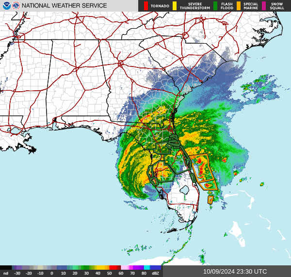
The northern eyewall of Hurricane Milton is beginning to move
onshore of the Florida gulf coast near Tampa and St. Petersburg
where an Extreme Wind Warning is now in effect. Please shelter in
place as these extremely dangerous hurricane-force winds overspread
the region.
A sustained wind of 61 mph (98 km/h) and a gust of 77 mph (124 km/h)
was recently reported at a WeatherFlow station at Egmont Channel. A
sustained wind of 44 mph (71 km/h) and a gust of 77 mph (124 km/h)
was recently reported at the Sarasota-Bradenton International
Airport. A sustained wind of 55 mph (89 km/h) and a gust of 71 mph
(114 km/h) was recently reported at a WeatherFlow station at Skyway
Fishing Pier.
The next update will be the intermediate advisory at 800 PM EDT
(0000 UTC).
SUMMARY OF 700 PM EDT...2300 UTC...INFORMATION
-----------------------------------------------
LOCATION...27.1N 83.0W
ABOUT 35 MI...50 KM WSW OF SARASOTA FLORIDA
ABOUT 140 MI...225 KM SW OF ORLANDO FLORIDA
MAXIMUM SUSTAINED WINDS...120 MPH...205 KM/H
PRESENT MOVEMENT...NE OR 55 DEGREES AT 15 MPH...24 KM/H
MINIMUM CENTRAL PRESSURE...952 MB...28.11 INCHES
$$
Forecaster Papin/Mahoney/Camposano
532
WTNT74 KNHC 092259
TUSAT4
Huracán Milton Ciclón Tropical Actualización
Centro Nacional de Huracanes del SNM Miami FL AL142024
700 PM EDT miércoles 09 de octubre de 2024
...PARED NORTE DE MILTON COMENZANDO A EXPANDIRSE EN TIERRA A LO
LARGO DE LA COSTA DEL GOLFO DE FLORIDA...
...700 PM EDT ACTUALIZACIÓN DE POSICIÓN...
La pared ocular norte del Huracán Milton está comenzando a moverse
en tierra de la costa del golfo de Florida cerca de Tampa y St.
Petersburg, donde un Aviso de Viento Extremo está ahora en efecto.
Por favor refugie en su lugar mientras estos vientos con fuerza de
huracán extremadamente peligrosos se extienden por la región.
Un viento sostenido de 61 mph (98 km/h) y una ráfaga de 77 mph (124
km/h) se informó recientemente en una estación de WeatherFlow en
Egmont Channel. Un viento sostenido de 44 mph (71 km/h) y una ráfaga
de 77 mph (124 km/h) se informó recientemente en el Aeropuerto
Internacional de Sarasota-Bradenton. Un viento sostenido de 55 mph
(89 km/h) y una ráfaga de 71 mph (114 km/h) se informó recientemente
en una estación de WeatherFlow en Skyway Fishing Pier.
La próxima actualización será la advertencia intermedia a las 800 PM
EDT (0000 UTC).
RESUMEN DE 700 PM EDT...2300 UTC...INFORMACIÓN
-----------------------------------------------
UBICACIÓN...27.1N 83.0W
ALREDEDOR 35 MI...50 KM OSO SO DE SARASOTA FLORIDA
ALREDEDOR 140 MI...225 KM SW DE ORLANDO FLORIDA
VIENTOS MÁXIMOS SOSTENIDOS...120 MPH...205 KM/H
MOVIMIENTO ACTUAL...NE O 55 GRADOS A 15 MPH...24 KM/H
PRESIÓN CENTRAL MÍNIMA...952 MB...28.11 PULGADAS
$$
Pronosticador Papin/Mahoney/Camposano
*** Este producto ha sido procesado automáticamente utilizando un
programa de traducción y puede contener omisiones y errores. El
Servicio Nacional de Meteorología no puede garantizar la precisión
del texto convertido. De haber alguna duda, el texto en inglés es
siempre la versión autorizada. ***
BULLETIN - EAS ACTIVATION REQUESTED
Extreme Wind Warning
National Weather Service Tampa Bay Area Ruskin FL
636 PM EDT Wed Oct 9 2024
The National Weather Service in Ruskin has issued a
* Extreme Wind Warning for...
Manatee County in west central Florida...
Pinellas County in west central Florida...
Hillsborough County in west central Florida...
* Until 930 PM EDT.
* At 635 PM EDT, National Weather Service Doppler radar indicated
extreme winds, associated with the eyewall of Hurricane Milton,
were moving onshore along a line extending from 6 miles southwest
of South Bradenton to 25 miles southwest of Anna Maria to 52 miles
southwest of Saint Armands Key, moving northeast at 30 mph. THIS
IS AN EXTREMELY DANGEROUS AND LIFE-THREATENING SITUATION!
PRECAUTIONARY/PREPAREDNESS ACTIONS...
TAKE COVER NOW! Treat these imminent extreme winds as if a tornado
was approaching and move immediately to the safe room in your
shelter. Take action now to protect your life!
&&
A Tornado Watch remains in effect until 900 PM EDT for west central
Florida.
LAT...LON 2812 8289 2815 8206 2739 8209 2739 8260
2735 8268 2786 8291
TIME...MOT...LOC 2235Z 242DEG 27KT 2740 8267 2735 8309 2699 8334
$$
TBW


No comments:
Post a Comment