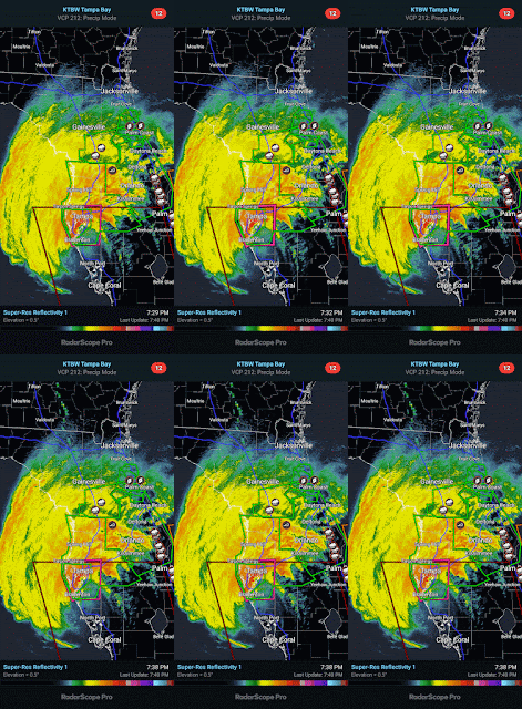
So now we have landfall.
Ryan Hall reports six people so far killed by this hurricane - a drowning in Mexico, then some deaths from a tornado in Florida, plus a wreck during evacuation. It will probably be until at least tomorrow before we'll know what the full impacts are from the actual eyewall of the hurricane itself. Hopefully most people got out of the way. A hurricane with 120 mph winds and a strong storm surge/flooding threat is not something you can afford to fool around with. And most people didn't, it looks like.
8:47 PM - Just a quick update to pass on some thoughts I found from some meteorologists online. Obviously if you are having flooding, then you want to shelter on the lowest DRY floor of your home or whatever building you've taken cover in down there. If you are trapped by flood waters, try calling 911, but don't try to drive through those waters.
But even if there is a tornado warning, if the lowest floor is so flooded that somebody could drown, then you'd want to shelter on the lowest dry floor. Now that I've typed that out, it sounds like common sense. I guess the bottom line is that the situation is dangerous for anybody in the areas that will be hit the hardest. By tomorrow afternoon, this thing should be out in the Atlantic and going post-tropical. So we'll see what it did. If you're caught in the direct path of the eyewall, just do the best you can. It can be a tough balance to protect yourself from the winds and the flooding.
000
WTNT64 KNHC 100030
TCUAT4
Hurricane Milton Tropical Cyclone Update
NWS National Hurricane Center Miami FL AL142024
830 PM EDT Wed Oct 09 2024
...EXTREMELY DANGEROUS CATEGORY 3 HURRICANE MILTON MAKES LANDFALL
NEAR SIESTA KEY FLORIDA....
...LIFE-THREATENING STORM SURGE, EXTREME WINDS, AND FLASH FLOODING
OCCURRING OVER THE CENTRAL FLORIDA PENINSULA...
NWS Doppler radar data indicate the eye of Hurricane Milton has
made landfall near Siesta Key in Sarasota County along the west
coast of Florida.
A sustained wind of 78 mph (126 km/h) and a gust of 97 mph (156
km/h) was recently reported at a NOAA C-MAN station in Venice. A
sustained wind of 77 mph (124 km/h) and a gust of 100 mph (161 km/h)
was recently reported at a WeatherFlow station at Egmont Channel. A
sustained wind of 67 mph (107 km/h) and a gust of 83 mph (133 km/h)
was recently reported at a WeatherFlow station at Skyway Fishing
Pier. A sustained wind of 40 mph (64 km/h) and a gust of 73 mph (117
km/h) was recently reported at the Sarasota-Bradenton International
Airport.
The next update will be at 900 PM EDT (0100 UTC).
SUMMARY OF 830 PM EDT...0030 UTC...INFORMATION
-----------------------------------------------
LOCATION...27.3N 82.6W
ABOUT 5 MI...10 KM W OF SARASOTA FLORIDA
ABOUT 115 MI...185 KM SW OF ORLANDO FLORIDA
MAXIMUM SUSTAINED WINDS...120 MPH...205 KM/H
PRESENT MOVEMENT...ENE OR 60 DEGREES AT 15 MPH...24 KM/H
MINIMUM CENTRAL PRESSURE...954 MB...28.17 INCHES
$$
Forecaster Reinhart/Papin/Brown/Mahoney/Camposano


No comments:
Post a Comment