Tuesday, October 29, 2024

Fall Review of Severe Weather Safety Rules

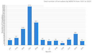
Our main tornado season in the Tennessee Valley is in March, April, and May - the Spring months. 


But we have to watch the late Fall/early Winter too, usually the month of November. 

The best source to get severe weather alerts is a NOAA Weather Radio. A phone service like Weathercall is also good. 

At minimum, everyone needs to have Wireless Emergency Alerts enabled on a cell phone. 

And no one should rely on an outdoor siren as their primary source. Many people have lost their lives because they expected a siren to wake them up, which is a purpose outdoor sirens are not meant to serve. 

A severe thunderstorm is a thunderstorm that produces winds of at least 50 knots (58 miles per hour) or hail at least one inch in diameter (the size of a quarter). 

A Severe Thunderstorm Watch means that conditions are becoming favorable for the development of severe thunderstorms over the next several hours, in and close to the watch area.

A Severe Thunderstorm Warning means that a severe thunderstorm is believed to be developing or already occurring within the warned area. This can be based on radar, a reliable report, or both.

A Tornado Watch means that conditions are favorable for tornadoes (and severe thunderstorms) over the next few hours, in and close to the watch area.

A Tornado Warning means that a tornado is believed to be developing or already occurring in the warned area. People within the warning polygon need to take immediate action to protect themselves. 

A Particularly Dangerous Situation is exactly what it sounds like, and can be used for a watch or a warning. It's up to the judgement of the forecaster issuing that watch or warning. 

I guess in a utopia, everyone would have an actual storm shelter in their basement or in their back yard somewhere. In reality, most people don't even have a basement. 

And a lot of the battle is getting people out of a mobile home and into a sturdy house or other strong building before a tornado hits. Staying in trailers is how most people around here die in tornadoes

In a site-built house, the safety rules are:

* Stay away from windows.

* Get to the lowest floor.

* Try to be in a smaller room like a bathroom, closet, or hallway.

* Make that room near the center of the building, put some walls between you and the outside.

It can also help to cover your body, especially your head, with blankets or something like a pillow, in case of flying debris. Or if you really want to go the extra mile, wear a safety helmet. (Most people have an old football or bike helmet around somewhere.) Theodore Fujita even recommended those after seeing how some people's lives were saved in some of the extra-damaging tornadoes by having that protection against head/neck injuries. 

In a basement, it makes sense to still stay away from any windows and to get up under something sturdy like a table, desk, set of stairs, or even a workbench in case of falling debris.

And if you have time to think about it, it's good to wear your strongest pair of shoes or boots to your shelter, in case you have to walk across debris after a storm. If you can carry a noisemaker like an air horn, sometimes that can help you alert rescue workers to your location if you were to be trapped by debris. We all hope these worst-case scenarios don't happen, but on the chance they were to, an ounce of prevention . . . can help a whole lot. 

If you will be driving while severe weather is a threat, plan at least three or four places you could pull over and get inside. Vehicles are generally not much safer than mobile homes in a tornado. And that old idea of getting up under a bridge is a myth

If you're more unnerved by severe weather than the average person, the National Weather Service in Kansas City has put together an excellent page for you. And a lot of people have good reasons to feel that way. Anybody who lived through the 2011 outbreak knows what I'm talking about. Or if anybody was around for the one in 1974, you know that if you or somebody you know went through a really bad storm, or even had a close call, that stuff stays with you. These simple things can protect you and the people you love. So please keep them in mind in case we do have problems over the next month or so, before Winter gets here. 

7:14 PM - Afterthought - If you have no sturdy building to get into, like not even a gas station, as a last resort, you should leave a mobile home and get into an unflooded culvert, ditch, or even lie flat on the ground, covering the back of your head and neck as best you can. While this is a last resort, the two tornadoes I'm thinking about people surviving by leaving a mobile home or vehicle were rated E/F-4 and F-5. One was during the Super Tuesday Outbreak of 2008, where a trucker actually left his vehicle and held onto a tree, because he waited until the last minute to do anything. But he had only minor injuries. The truck was thrown some distance away and destroyed. And then I believe it was at Mount Hope in April 2011, that infamous E/F-5 tornado that tracked from Hackleburg through Harvest and even a little into Tennessee, I remember a story of an elderly couple who left their mobile home and survived in a ditch. I would have to check, but I don't recall that they were even injured. So let that be a comfort maybe. Even in the worst tornadoes, and even under bad circumstances, there is usually something you can do. 

And as much as I'm wanting people to be cautious and play it safe, tornadoes are relatively rare events that don't cover a lot of ground, compared to a city or county. The odds of being hit directly, especially by the worst winds, are really low. I'd still encourage anyone living around here to respect the danger they bring. I've had more than one person from California comment that they would much rather go through an earthquake than a tornado, or that they wonder how we cope with them, like it must really be a headache for places like hospitals. From what I've seen, places like hospitals use really good sense about severe weather around here. With everyday citizens, it varies. So those of us who care should do our part. The National Weather Service in Birmingham likes to say you can "be the hero" in your family or circle of friends by staying aware and knowing what to do if you find yourself in the path. 

Some people might need to use a public shelter, and I salute Craig Ceecee for putting together a national map of those. They can be lifesavers for people who live in mobile homes. 

7:37 PM - Found that article from Chris Darden about the April 2011 superoutbreak, which contains the story of the elderly couple surviving that E/F-5 tornado in a drainage ditch. It is worth reading anyway, has a lot to teach about severe weather safety. And that was a very rare, nightmare kind of a day. You might see one or two severe weather outbreaks like that in your whole life. Most of them are going to be the lower-risk events, but all it takes is one tornado or really damaging thunderstorm, and it's a big deal for whoever gets the worst of it. So they need to be reasonably prepared, whether they're at home, at work, at school, or caught out driving somewhere. 

Mostly Staying Warm and Dry, Brief Cooldown with Low Rain Chances Halloween Night into Friday Morning

Wednesday (High 80, Low 57): Mostly sunny. Warm and breezy. 

Halloween (High 80, Low 60): Partly to mostly sunny and breezy. Widely scattered showers are possible, mainly at night.

Friday (High 74, Low 62): Partly to mostly sunny, breezy, and turning cooler. Isolated showers are still possible, mainly in the morning. 

Saturday (High 79, Low 57): Mostly sunny. 

Sunday (High 80, Low 58): Mostly sunny. 

Monday (High 81, Low 57): Sunny.

Election Day (High 81, Low 58): Sunny with hazardous social tensions reaching one of their plateaus. 

It has been a mostly sunny day in Cullman with a southerly breeze at times. 

Our High was 77, and the morning Low was 57. It was technically 57.2, I mention for the anal-retentive.

Which I suppose sometimes I can be. Details details. 

Ah . . . nice . . . the Stormy cat just spilled grape juice on about half a dozen books I had stacked up. Never underestimate the power of a stir-crazy, ditzy feline to knock a cup over in the process of taking a flying leap through a living room. 

The mess is mostly up, so let's see if this forecast can work out anyway . . . the remainder of the mess is drying between pages of these books, which will never be the same. Thank goodness one was hardcover, well actually two, and I carelessly threw some salespapers on top of some of them. So they weren't as ruined as they could have been. This cat is now beckoning for my affection. She ain't gettin' it. She gets the cold shoulder for the rest of the night. Ya' wanna get on my bad side, mess with my books. 


Anyway we're under a ridge of high pressure again. 

Tomorrow looks a lot like today, mostly sunny skies, High of about 80 or so, Low of about 57. And it'll be breezy at times, with winds from the South/Southeast.

And Halloween just looks plain creepy, especially at night, ghouls and goblins likely. Houses on fire, they're blowing up cars, creatures on the street, and razor blades in candy bars . . . with a nod of respect to the Insane Clown Posse.

But seriously it looks like a mix of sun and clouds, High near 80, Low near 60. And it'll be another breezy day. Will include a 30% chance of rain, but that's mainly after dark. I think most trick-or-treaters will stay dry, but if you're up around the Shoals or into Central Tennessee, might want to check the radar before heading out. Or I guess you could just wear a hood and look spookier anyway. 


And I think there's enough evidence of moisture along this slow-moving front to justify rain chances lasting into Friday, the Day of the Dead. I'm not gonna' put zombies in the forecast, but the people who know, know. Usually I'm against the paranoid conspiracy theories on here, but hey, this is the most wonderful time of the year. You might find yourself travelling through another dimension if you stay up too late Thursday night into Friday . . . and who knows what lurks therein . . . 

The chance of rain Friday looks very low though, about 20%, which means isolated showers. Temperatures will be dropping, the High on Friday only making it up to the lower 70's, maybe mid-70's for a few of us. The Low temperature in the lower 60's overnight. 

Saturday looks dry again with a High near 80, Low in the upper 50's. If none of the rest of this discussion creeps you out, that should give you some deja vu. 

Similar weather for Sunday. (Every day is exactly the same . . . with a nod to Trent Reznor and the Nine Inch Nails . . . slaps self for singing on the job.)


And really no significant change in the weather Monday or Tuesday. Tuesday of course is the election, and so I feel obligated to include in the forecast discussion that we'll have a lot of pissed-off people that may prove more frightening than any of the banshees, vampires, or werewolves prowling around the streets of London (or Cullman) the next few nights. So enjoy All Hallows Eve while you can. 

I think most folks in Alabama and Tennessee will be pleased with the outcome of this one, but still, getting from point A to point B can be a hell of a ride sometimes. I remember at one point during the virus outbreak, this guy with scraggly hair came into a store ranting and raving about communists. I was in line. I hollered along with him for a little bit and tried to express sympathy even though I couldn't make out half of what he was saying. And then . . . I checked out in a hurry. It's better for everyone if I don't go into detail about my political opinions on here. The only thing I'll say is that it'd be nice if so many of the offices up for election locally had more than one option and a write-in slot. I was going to research these people, but when they are unopposed . . . boy, that sure does save some time on research. And I will say that I don't think my vote or anyone else's will matter one bit in this presidential election. (I was only hoping to matter one way or the other in the local stuff.) The electoral college has the final say. We all know how they're going to vote. Agreeing with them adds nothing. Disagreeing with them subtracts nothing. The only reason to vote in this thing is to make a statement, if only to oneself. But the popular vote really doesn't mean anything, as far as who wins. Since we're still doing votes the way they did when they had to be delivered on horseback. I do have a morbid curiosity as to how many people will write in somebody interesting. But that probably won't happen. So I'm not even looking for entertainment value in this one. I'll always wonder what kind of president someone like Neil Tyson would have made. But I guess somebody like him is smart enough not to run. He knows it'd turn the rest of his hair white faster than if he became a ghostbuster this time of year. 


The tropics are quiet for now, but we could see a tropical depression develop from a low pressure system in the Caribbean as we get toward this weekend. Its track would probably be North/Northeast, but it's just something to keep an eye on. Hurricane season lasts through November. 

And November tends to be a secondary severe weather season for North Alabama and Southern Middle Tennessee. So we'll have to watch any storm systems for about the next month for that potential, especially considering how warm we've been this year. 

The National Weather Service in Nashville is holding Weather 101 classes again. Oddly enough they have a class on severe storms on Election Day. Which will be a beautiful day, sunshine, with a High of 80 or so. But they have a variety of subjects they give classes on. 

I thought about instead of posting severe weather safety stuff every year, maybe I'll just start plugging the SKYWARN classes more that the NWS offices hold every Spring and Fall. Those classes are free, and sometimes I wonder if the people who don't care enough to take one really care much if a tornado is coming anyway. 


If we get any rain, it should be Friday night into Thursday morning. We're in a bit of a drought again. Best chance is Northwest Alabama up into Tennessee. 

If you'd like to see these posts more often, please consider buying me a coffee, so to speak.

Footnote Wednesday evening October 30th - A lot of my ranting about the electoral college should be taken with a grain of salt. For accurate information, see here. It turns out that Alabama is one of the states that does have a law binding the electors to vote according to the popular vote. I went looking into it again . . . 

Saturday, October 26, 2024

Warm and Dry Most of the Week/Some Rain Possible By Next Weekend

FORECAST:

Sunday (High 78, Low 55): Partly to mostly sunny. 

Monday (High 80, Low 54): Mostly sunny. 

Tuesday (High 81, Low 56): Mostly sunny.

EXTENDED OUTLOOK:

Wednesday (High 80, Low 59): Partly to mostly sunny.

Halloween (High 79, Low 60): Partly cloudy with a 20% chance of showers/thunderstorms.

Friday (High 75, Low 61): Partly cloudy with a 30% chance of showers/thunderstorms. 

Saturday (High 77, Low 60): Mostly sunny with a 20% chance of a shower or thunderstorm.

PRONÓSTICO:

Domingo (Máxima 78, Mínima 55): Parcialmente soleado.

Lunes (Máxima 80, Mínima 54): Mayormente soleado.

Martes (Máxima 81, Mínima 56): Mayormente soleado.

PERSPECTIVA EXTENDIDA:

Miércoles (Máxima 80, Mínima 59): Parcialmente soleado.

Noche be Brujas (Máxima 79, Mínima 60): Parcialmente nublado con un 20 % de probabilidad de lluvias o tormentas eléctricas.

El Día de los Muertos (Máxima 75, Mínima 61): Parcialmente nublado con un 30 % de probabilidad de lluvias o tormentas eléctricas.

Sábado (Máxima 77, Mínima 60): Mayormente soleado con un 20 % de probabilidad de lluvias o tormentas eléctricas.

NOTES:

The National Weather Service in Nashville is holding Weather 101 classes again. And as usual, they are free to take, and can be taken online. These are good. You know anybody interested in meteorology, tell 'em about it. 

There is still a lot of need for help after Hurricanes Helene and Milton, and the best three sources I know of to look into are FEMA, the Samaritan's Purse, and the Red Cross

DISCUSSION:


It has been a mostly sunny day in the Tennessee Valley, a few periods it got a little breezy. But mostly a sunny day with light and variable winds. There are a few light rain showers out ahead of this cold front moving through the area, but some of these echoes are so light that it's probably just virga, rain that evaporates before it even reaches the ground. 

The High in Cullman was 82, and the Low was 52. The High in Jasper was 86 with a Low of 48. We're having some fog in the mornings, which is typical for this time of year. But we sure are warmer than average. Some of us would even call this "too hot" for October. Haleyville saw a High of 81 and Low of 52. Huntsville has been seeing more clouds this evening with the front moving through, and their High was 86 today after a morning Low of 55. Nashville actually saw some light rain earlier this evening, as isolated as the rain has been with this mostly dry front, and they had a High of only 70, and so far today, the Low has been 64. It is back to that currently and may drop below that before Midnight, probably will. They were overcast much of the day up there. So even in our quietest month here, you can find interesting little variations in the weather over a pretty focused segment of the great fruited plain. 


That cold front will continue to move through the region tonight into early tomorrow morning. Any additional rain we see is going to be so isolated, I wouldn't worry about it. The Low tonight will be about 55, and the High tomorrow will be about 77-78 degrees. This front is not going to cool us off much. It is a weak frontal boundary, but I guess we'll take what we can get for now. 


Monday will be a sunny day with a High near 80, a Low in about the 53-55 range. 


Tuesday also looks sunny with a High near 80 again, a Low in the mid-to-upper-50's. Monday and Tuesday, we may see some fair-weather clouds around at times because of some South/Southeast winds at times, but much more sunshine than any clouds. Here lately a lot of days, you could barely find a cloud in the sky. 


Wednesday will also be mostly sunny. Again a High near 80. The Low may actually approach 60 again but probably staying in upper 50's for most of us. 


Then Thursday is going to be interesting. Of course that's Halloween, and a lot of people will be taking their kids out to collect candy. The timing of that cold front is going to be key. Even about Noon or 1 PM (since we're still on Daylight Time), the global models are showing moisture for rain getting into about Memphis. Whether we see that later in the evening around here is a real toss-up for now. We might get by with a dry trick-or-treating forecast, but there is enough a chance for showers or even some storms that I'm going to introduce at least a 20-30% chance of rain here. High should be near 80, Low near 60. 

That high pressure ridge may keep us from getting any rain or thunderstorms, but it is a close call. It's more likely to see something Thursday night than during the day, if we do. 


Certainly by Friday, the first day of November, we have to consider the chance of some rain/thunderstorms. It looks like the high pressure ridge is going to slow this front down. So for now thinking only a 20% chance of rain for Thursday/Thursday night, then for Friday, increase the chance to 30%. This has an unsettled look, not a washout look. High in the mid-70's instead of up near 80. Similar Low temps. 


Then for next Saturday, that chance goes back to just a 20% chance of isolated showers or thunderstorms. And our Highs rebound to the upper 70's. 

When we get toward November each year, we do have to look out for the potential of severe thunderstorms, sort of like in the Spring months, can also have problems like that in the late Fall. But for right now, all signals point to weak instability available, so if any stronger storms develop, they should be isolated, and the situation would probably stay marginal. And we may get by without any severe thunderstorm threat at all through next weekend. It's just that time of year when you can't be too careful, so mentioning it in passing, even though the risk of any storms getting out of hand appears very low. 


About the middle of next week, a low pressure system is forecast to develop in the Southwestern Caribbean Sea. The computer models have been showing it. It is expected to sort of drift around with some slow movement to the Northeast, and any development of it is expected to be slow. 

Please remember that instead of the scare stories that get more clicks. Be one of the wiser people . . . why not?

They sure are in short supply these days, and sadly, I often can't count myself among the people using the best judgement. That's one reason I enjoy the challenge of having to dissect and analyze things logically here. It makes the rest of the world easier to sort out, like it's easier to sniff out the bullbutter and get away from it. 


Out in the Pacific Ocean, Tropical Storm Kristy is not long for this world. It will dissipate before we get to Monday most likely. 

So the tropics are quiet again. Hurricane season technically lasts through the end of November, and we do have to stay cautious this year, especially as warm as we are staying. The waters are warm too. Things usually wind down as we get into November, but we've had some late season surprises. I think that happened in 2020, but I'd have to check. I just remember the season was insanely active that year. They ran out of names and started having to use Greek letters. 


We may see some rain by this next weekend, but it's kind of dicey, and the best chance will probably be over Northwest Alabama up through West Central Tennessee. 


CHITTER-CHATTER:

A couple days ago, I posted a lot of blunt, personal thoughts off the top of my head at the end of a forecast discussion. I still lapse into doing that once in a while. I prefer not to. If I'm going to go on a wild tirade, I'd rather it be something funny, like making fun of all the paranoid conspiracy theories going around lately. Not all of them are about hurricanes. By the way, my offer still stands, that if anybody thinks I'm one of the "elite" who can control the weather, all they have to do is let me know where they live, and I'll see if I can send them a hurricane. But I don't give refunds for this service. Success is not guaranteed, and neither is one's survival if the hurricane does hit as requested. So far, nobody's asked me for a hurricane. Which bums me out. That would have been such a fun conversation. I guess everybody's trying to get in touch with HAARP for their hurricane needs instead. 

You know what, that's the end of my chatter today . . . except to say I got hold of a bad pizza roll last night, tasted about like a rotten potato or something. I spit it out. And I don't know if I just undercooked that batch or if I'm going to have to throw the whole bag out. Guess it beats getting one of those bad quarter pounders from Mickey D's here lately. 

How's that for deep wisdom of the universe?

I've got nothing better tonight. 

And I'm finishing this up hours later because somebody needed help getting peanut butter out of a cabinet, and then I got on the phone with somebody else. Hope this forecast discussion was coherent. 

Thursday, October 24, 2024

Warm, Dry Pattern Continues

FORECAST:

Friday (High 84, Low 52): Sunny. Warm.

Saturday (High 81, Low 55): Mostly sunny. 

Sunday (High 78, Low 51): Mostly sunny.

EXTENDED OUTLOOK:

Monday (High 75, Low 53): Sunny.

Tuesday (High 77, Low 54): Sunny.

Wednesday (High 79, Low 58): Mostly sunny.

Halloween (High 80, Low 59): Partly to mostly sunny. 

PRONÓSTICO:

Viernes (Máxima 84, Mínima 52): Soleado. Cálido.

Sábado (Máxima 81, Mínima 55): Mayormente soleado.

Domingo (Máxima 78, Mínima 51): Mayormente soleado.

PERSPECTIVA EXTENDIDA:

Lunes (Máxima 75, Mínima 53): Soleado.

Martes (Máxima 77, Mínima 54): Soleado.

Miércoles (Máxima 79, Mínima 58): Mayormente soleado.

Noche de Brujas (Máxima 80, Mínima 59): Parcialmente a mayormente soleado.

Sunday, October 20, 2024

A Calm Forecast Tempered By a Heavy Heart

Monday (High 80, Low 43): Sunny.

Tuesday (High 80, Low 46): Sunny.

Wednesday (High 81, Low 49): Mostly sunny.

Thursday (High 79, Low 52): Mostly sunny.

Friday (High 78, Low 47): Sunny.

Saturday (High 79, Low 48): Sunny.

Sunday (High 80, Low 50): Sunny.

It was a sunny day in Cullman with a High of 75 and a Low of 41. 

The reason I'm posting something tonight is that I've learned of the death of Brett Elmore, the owner of WJLX 101.5 FM in Jasper. I found out nearly a week late, in a roundabout way. I usually listen to that station once a week, their Sunday night show, Coyote J's Cemetery of Rock. I noticed that show didn't come on today. And then I did something I almost never do, checked the station's Facebook page. I quit FB years ago, but you can still look at some pages without an account. And I am still sort of in shock. I only knew Mr. Elmore casually, but the interactions with him I remember were good ones. I loved what he was doing with that station. And it turns out tonight was the night they had a Celebration of Life party for him. It sounds like he died suddenly on the 14th, so that was this past Monday. And he was only 41 years old. I just thought I would take the time to express sadness and condolences to his friends and family. And say that I thought he was a great guy. I am still sort of reeling from the news. 

So before we get into the weather, here is a good story that CBS-42 in Birmingham posted about Brett's untimely passing. And here is a tribute they did to him on the Bama Tailgate show

By the way, the only reason I didn't listen to the radio station all the time was that they pretty much cut off the music at the year 2000. I listen to a mix of classic and new rock. So I listened more to the local station Live 95 in Cullman owned by Jay Fuller. But I also love that Jasper station, and if I was living down there again, that would be my #1 station. I really loved what Brett Elmore was doing in trying to preserve the tradition of radio, the way it should be done. There are real personalities behind the voices on the air on that station. His voice will certainly be missed . . . a lot. 

It's been a tough year with regard to the grim reaper. There was an evening two people in my family had a close call with two different tornadoes, both stronger than average (rated E/F-3 and E/F-2), but they made it, weren't even hurt, not even any damage. Just a close call . . . in one case the tornado passed only a mile away, or may have been less than a full mile. And then a few months later, a cousin of mine committed suicide. (I know you're supposed to say "died by suicide" these days, but I don't care. I'll call it what it really is. It is a tragic decision.) And now one of the people I really looked up to in radio is gone all of a sudden. And . . . I'm just not feeling too eloquent about it. 

Since he and the DJ he brought out of retirement (Coyote Calhoun) on WJLX 101.5 FM were both known for a great sense of humor, I guess I'll close my sappiness here by saying that maybe at least now he knows whatever happened to their radio tower. I joked at the time that it was abducted by aliens, because the mystery still has not been solved as to how it was stolen. (I assume it was. Those things don't just disappear. You'd have to at least bring in David Copperfield to vanish something that big.) And the story was carried prominently on Coast to Coast AM, Art Bell's old show that is now hosted by George Noory. Betty White used to say that whenever somebody she knew died, she would say, "Now they know." They understood what life had been all about. I remember thinking when she passed away, "Now she knows." And so I guess I'll say Godspeed to this man who did such great things in local radio; now he knows. The rest of us still wonder what happened to that radio tower, as we wonder about so many other things that don't make a whole lot of sense. 

In all seriousness, I'm glad his friends are carrying on that station the way he would have wanted, as they mentioned on the Facebook page as I was skimming it. And I guess I'll remind my more serious readers of something Carl Jung said, when giving his reasons he believed there was life after death. He probably said it more eloquently than I'm remembering, but he said that death was a terrible blow and that there was no sense in pretending otherwise. Everybody who knew Brett Elmore, even as casually as I did, is going to miss him. That's just the way it is. It's rough to lose people. 

Oddly enough, I was reading a short story tonight that was largely a meditation on death, before I found this news. But as one preacher-man from Winston County once said, if you talk about death too long, "you'll clean a house out!" So I'm going to get on to the weather. 

But I really do find it sad. And this is one time I don't care if people think I'm being too much of a bleeding heart or whatever. This is a heartbreaker. 

And that's the best I've got, just writing off the top of my head, when the reality has yet to fully sink in. 

I guess I could encourage people to check out that radio station if you don't already know how good it is. It is about as fine a classic rock station as you'll find anywhere. I'm listening to it now because these songs provide some solace. 


We are going to remain under a ridge of high pressure for the duration of this forecast period, for the next week or so. 

Tomorrow that translates to sunny skies and a High near 80, morning Low in the lower 40's, about 43, maybe 44. We could see patchy fog tomorrow or really any of these mornings, time of year for that, but usually it dissipates shortly after sunrise. 

Basically the same for Tuesday except the Low will be in the upper 40's instead of lower 40's. 

Lows might approach 50 by Wednesday, Highs staying about the same. 


The only real punctuation mark in this forecast is a cold front on Thursday, not expected to bring us any rain, probably just a few fair-weather clouds. Breeze might pick up as it comes through. But it is expected to be a dry cold front. 

And it is not a particularly strong one either. Thursday we'll see a High in the upper 70's and a Low in the lower 50's. Then Friday we'll have a morning Low in the upper 40's again . . . that's about as much of an extra push of colder, drier air we're going to get from this system. Then next weekend, Highs near 80, Lows near 50. 


Hurricane Oscar has been affecting mainly Eastern and Northeastern parts of Cuba. It is just barely a hurricane anymore, and is expected to track Northeast at tropical storm strength before dissipating by about Thursday of this week. It will bring the potential for tropical storm conditions to the Southeastern Bahamas as well. Main thing to look out for is flooding along that Northeast coast of Cuba. I doubt I've got any readers down that way, but just in case. I hear the cigars are good there. A little old lady told me so. 


No rain expected around here any time soon. 

They're playing "These Dreams" by Heart on 101.5 in Jasper. It seems fitting, the lyrics . . . these dreams go on . . . 

Saturday, October 19, 2024

Staying Sunny with Mild Temperatures

FORECAST:

Sunday (High 77, Low 40): Sunny and cool. Patchy fog possible in the morning. 

Monday (High 80, Low 44): Sunny. Mild.

Tuesday (High 79, Low 47): Sunny. Mild.

EXTENDED OUTLOOK:

Wednesday (High 80, Low 49): Mostly sunny.

Thursday (High 78, Low 52): Mostly sunny.

Friday (High 79, Low 46): Sunny.

Saturday (High 80, Low 50): Mostly sunny. 

DISCUSSION:


We had a sunny day in Cullman with a High of 73 and a Low of 41. There was some occasional breeziness, but most of the day, the winds stayed pretty calm. Jasper had a High of 75 and a Low of 36, talk about a temperature gradient. And Haleyville had a High of 73 and a Low of 37 today. 

What got my attention was the tropics. so we'll start there. 


We have Tropical Storm Nadine, which has already made landfall at Belize City this morning. 


It's been sort of a short-fused system, but it will continue to bring heavy rains and gusty winds down that way. 

And of more interest since it is stronger and more of a surprise at how fast it's strengthened, is Hurricane Oscar

Which has prompted a Hurricane Warning for the Turks, Caicos, and Southeastern Bahamas; and a Hurricane Watch for eastern parts of Cuba. 


This is a very small hurricane, and its winds are expected to peak at about 90 miles per hour before it turns back to the Northeast and weakens to a tropical storm. So it's kind of interesting, this system that came all the way from the West Coast of Africa a week or so ago has been full of surprises. As of a day or two ago, nobody thought it was going to develop into anything anymore. And then in the space of one day, it ramped up into a hurricane. You can't trust these anomalously warm waters this year. 

Nonetheless, it is expected to dissipate over open waters by Thursday. 


We'll remain under a ridge of high pressure in the Southeast tomorrow. We may see some patchy fog in the morning, but overall another sunny day, may not see a cloud in the sky. We'll see a High of about 77 and a Low of about 40. 


Then Monday looks sunny again, High near 80, Low about 43-45 range. 


Then on Tuesday, that low pressure system in the Desert Southwest is expected to move up into the Great Lakes region and morph into more of a shortwave trough. Our weather locally will stay roughly the same, High in the upper 70's, though the Low temperatures will rebound into upper 40's. 


Wednesday our winds aloft will be firmly from the Northwest again, high pressure at the surface. Skies stay sunny, High of about 80, Low near 50. 


Then on Thursday we actually get a dry cold front. Might mention a few clouds Wednesday/Thursday to account for this. Not expecting rain. 


This front does not look particularly strong, and we can expect a High in the upper 70's and a Low in the lower 50's. 


Looks like a clear sky and High in the upper 70's again for Friday, the Low dropping back into the 40's, maybe even mid-40's for many of us. 


The high pressure starts to move off to the Northeast by next Saturday, but skies should stay mostly sunny with Highs getting back up near 80 and Lows near 50. 


No rain expected around here any time soon. This is typically our calmest time of the year around here. 

Some Rain to Start the New Workweek, Then Another Cold Dry Spell

FORECAST: Sunday (High 55, Low 33): Partly to mostly cloudy during the day with an isolated shower or two possible. After dark, rain showers...