

FORECAST:
Friday (High 89, Low 63): Sunny. Patchy fog possible in the morning.
Saturday (High 90, Low 64): Sunny. Patchy fog possible in the morning.
Sunday (High 89, Low 65): Mostly sunny. Patchy fog possible in the morning.
EXTENDED OUTLOOK:
Monday (High 88, Low 66): Partly to mostly sunny.
Tuesday (High 87, Low 67): Partly cloudy with a 20% chance of a shower or thunderstorm.
Wednesday (High 83, Low 66): Partly cloudy with a 20% chance of a shower or thunderstorm.
Thursday (High 83, Low 62): Partly to mostly sunny.
BEACH FORECAST:
Friday (High 88, Low 74): Sunny.
Saturday (High 86, Low 76): Sunny.
Sunday (High 86, Low 75): Sunny.
PRONÓSTICO:
Viernes (Máxima 89, Mínima 63): Soleado. Posible neblina dispersa por la mañana.
Sábado (Máxima 90, Mínima 64): Soleado. Posible neblina dispersa por la mañana.
Domingo (Máxima 89, Mínima 65): Mayormente soleado. Posible neblina dispersa por la mañana.
PERSPECTIVA EXTENDIDA:
Lunes (Máxima 88, Mínima 66): Parcialmente a mayormente soleado.
Martes (Máxima 87, Mínima 67): Parcialmente nublado con un 20 % de probabilidad de lluvia o tormenta eléctrica.
Miércoles (Máxima 83, Mínima 66): Parcialmente nublado con un 20 % de probabilidad de lluvia o tormenta eléctrica.
Jueves (Máxima 83, Mínima 62): Parcialmente a mayormente soleado.
PRONÓSTICO DE LA PLAYA:
Viernes (Máxima 88, Mínima 74): Soleado.
Sábado (Máxima 86, Mínima 76): Soleado.
Domingo (Máxima 86, Mínima 75): Soleado.
NOTES:
Believe it or not, parts of Northeast Alabama into Southern Middle Tennessee are still experiencing drought conditions. Most of our region was helped greatly by the remnants of Hurricane Francine.
The National Weather Service offices in Birmingham and Nashville have scheduled SKYWARN classes ahead of the secondary severe weather season we often have in the month of November.


It was a partly to mostly sunny day in the Tennessee Valley. Cullman saw a High of 86 and a Low of 61. Jasper saw 90 degrees after a morning Low of 61. The High was 86 in Haleyville after a morning Low of 61. Huntsville saw a High of 90 after a morning Low of 65. And Nashville had a High of 91 after a morning Low of 67.
Not really seeing any measurable rain around here with high pressure firmly in control of our weather. We have a cold front bringing showers and thunderstorms to the Midwest. Some of those thunderstorms have reached severe limits out that way. And even along a weaker low pressure system around the Carolinas and through Georgia, convection is pretty isolated and limited until you get to Southern Florida, which can get some rain just about any time. They've got a good bit of it this evening.


Tomorrow looks sunny with high pressure centered just to our Northwest, a High of about 89-90, Low of about 63-64. Could see some patchy fog in the morning, and it's just the time of year for that. This pattern of clear skies, not much wind, longer nights is a good recipe for it, as the National Weather Service in Huntsville reminded everyone in their forecast discussion today.


Looks like basically the same for Saturday.


Then Sunday again looks mostly sunny with a High near 90, Low in the mid-60's.


Monday we'll see a slight increase in clouds as the cold front slowly gets closer to us. Might adjust Low temperature up a few degrees for that and drop High temperature a degree or two.


Then the front pushes in here on Tuesday, but interesting . . . the latest run of the GFS (and the ECMWF, not shown here, but peeked at by the blogger) is showing it coming through here mostly dry. Many previous runs have showed low chances for rains. Will keep a 20% chance of isolated rain in the forecast, a High in the upper 80's and Low in the upper 60's.


And the GFS does bring back hints of rain on Wednesday, so that's the right call, to keep a 20% chance in for both days. There may be enough cloud cover to bring the High down into the lower 80's on Wednesday. Low should stay in the upper 60's.


And here is a look at Tuesday through Thursday on standard weather maps, since I know raw model output is not the easiest to read. You can see the slow-moving nature of the front better here and how the rain looks really isolated.


By Thursday the rain chance is dicey, probably closer to 10% than 20%, so might not put in the forecast by this point. High should be in lower 80's, Low in lower 60's.
Oh and don't worry about the tropical system the GFS is showing moving through Florida at this time range. It almost never gets such things right at this time range. If we had agreement from the ECMWF I might get concerned, but we definitely don't.
And I started to do a 10-day forecast this time. Two reasons I didn't. First, the American and European models diverge too much beyond 7 days out, the former keeping us dry, the latter bringing us more rain chances from the Gulf. We're more likely to stay dry unless something happens with this second reason.


The remnants of Tropical Storm Gordon (shown by the #1) may redevelop as they move North/Northeast over the next few days. But the chance is relatively low.
Another area of low pressure, West of that, but about 750 Southeast of Bermuda, is producing disorganized showers and thunderstorms. Chances of it developing into anything are marginal, and it is going to meander over the open waters through next week.
The one everyone is watching closely is a system that has not formed yet, but that computer models keep showing will form early next week in the Northwest Caribbean Sea. By the middle of next week, we could see a tropical depression form as this moves into the Southern Gulf of Mexico. And if this all pans out, then everyone along the Gulf Coast will need to watch the progress of the system very carefully.
You can see all kinds of model forecasts and ensembles by just scrolling social media, but at this point, I decided not to put them here or try to analyze them. The reason for that is that the system has not even formed yet. There is not even anything for an aircraft to investigate, to feed the tropical models good information. This is one of those situations where a detailed forecast for the Gulf of Mexico, or any of the U.S. mainland, would strike me as dishonest. So if you want that, look elsewhere.
But of course, it is worth watching.
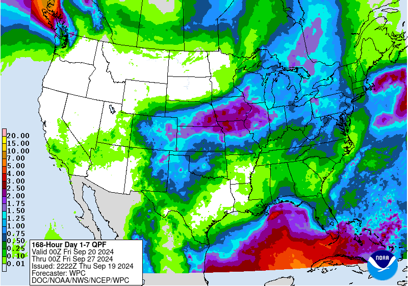
Rainfall totals should stay generally under a quarter of an inch. Any rain should come next week as that cold front approaches and slowly moves through.
This Sunday is the Autumnal Equinox. But the way things are going, I'm not too sure it's going to feel like Fall until we get into October.
I wrote out a lot of thoughts on social and political issues but scrapped them for now, might rework that writing at a later time if it seems right to do so. I'm not sure if my voice matters in such things in the first place, and even if so, I'm not convinced this is the proper forum for it. This is just a casual, amateur weather blog for now.


No comments:
Post a Comment