Tuesday (High 89, Low 67): Mostly sunny with an isolated shower or thunderstorm possible during the day. Rain will become likely at night, and any thunderstorms that form could produce strong, gusty winds.
Wednesday (High 79, Low 65): Periods of rain showers likely throughout the day and night. Patchy fog is also possible.
Thursday (High 74, Low 64): Rain showers likely. Cool, breezy at times.
Friday (High 77, Low 63): Mostly cloudy with a 40% chance of showers.
Saturday through Monday (High ~80, Low ~60): Mostly sunny.
Martes (Máxima 89, Mínima 67): Mayormente soleado con posibilidad de lluvias o tormentas eléctricas aisladas durante el día. Es probable que llueva por la noche y cualquier tormenta eléctrica que se forme podría producir fuertes ráfagas de viento.
Miércoles (Máxima 79, Mínima 65): Períodos de lluvias probables durante el día y la noche. También es posible que haya niebla dispersa.
Jueves (Máxima 74, Mínima 64): Probabilidad de lluvias. Fresco, con brisa a veces.
Viernes (Máxima 77, Mínima 63): Mayormente nublado con un 40 % de probabilidad de lluvias.
Sábado a Lunes (Máxima ~80, Mínima ~60): Mayormente soleado.
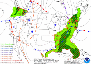
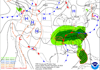
That cold front is advancing slowly toward our region. And we are waiting to see how our tropical storm or hurricane from that broad low pressure system in the Caribbean develops as it moves into the Gulf of Mexico. So the weather is a little more interesting than usual as we are in the last full week of September.
Next couple days, that front is going to slowly move through the area. And we'll have to watch for impacts out of that landfalling tropical cyclone (will probably make landfall as a hurricane in Florida) because of a strange pattern of movement expected after it comes inland.
I can't remember if they're going to call it Helene or Helena, but it's the "H" name anyway.
Tomorrow, or technically now it's already "today", Tuesday, expecting mostly sunny skies, only a 20% chance of an isolated, passing shower or thunderstorm somewhere in the region. High should be about 89, tonight's Low about 67.
Worth noting from the Storm Prediction Center, much of North Alabama and all of Southern Middle Tennessee is outlooked for a marginal 5% chance of damaging wind gusts with any thunderstorms that do form tomorrow/tomorrow night. Also worth mentioning that this risk is outlooked to the North of cities like Cullman, Jasper, and Double Springs. It does include Huntsville, Scottsboro, Florence, and Decatur. And it clips Hamilton.
Then Tuesday night into Wednesday, it is now looking like rain showers will be likely along with periods of patchy fog. And temperatures should cool rapidly from what they were, expecting a High in the 78-80 range, Low near 65.
We'll have to look out for flash flooding potential, especially in Northeast Alabama. The good side of that is that this could put an end to the last of our drought conditions, which have been lingering there and in parts of Southern Tennessee.
Interesting extended period this time: The hurricane remnants are going to be trying to move North and West while the low pressure center associated with our cold front will be trying to move South and East. And they may end up steering each other somewhat. Then they are actually expected to merge to our Northwest late in the extended period. This is called the Fujiwara Effect, and I've heard more than one forecaster say they've never seen it in this part of the country. So this is a very interesting pattern we've got going on. If the models are right about this.
Looks like showers again for Thursday, High in the lower 70's, Low in the lower-to-mid-60's.
On Friday the showers should become more scattered, about a 40-50% chance of rain, expecting a High in the mid-to-upper-70's and a Low in the lower 60's.
After that, the remnant low of the hurricane should merge with that regular low pressure system roughly to our Northwest. And that will put us in a dry slot for any rain if this computer model guidance turns out to be right. This is a high-uncertainty forecast. Let's remember that this tropical cyclone has not even formed yet with a well-defined eye that has been investigated by any aircraft to give us "ground truth" . . . or I guess "air truth" is a better term here. But seriously, I'll be glad when we have some actual observations from within the system. That way, the computer forecast models have a lot better information from which to calculate all this stuff. And at that point, I'll have more confidence in the model data that we're all basing our forecasts on. But we have to tell people something, with the system only a couple days away from landfall, if we can trust the models at this point. And they really are in unusually good agreement. This is an anomalous situation.
But going with the strongest probabilities, going to forecast mostly sunny skies for Saturday, High near 80, Low near 60.
Similar weather for next Sunday.
And looks like similar weather for next Monday.
So here is the main player in keeping our weather so interesting at the moment. Right now it is still just a disorganized low pressure system in the Caribbean.
Good news, I just noticed something I read from the Hurricane Center that says a reconnaissance aircraft is going in to investigate this thing in the next few hours. So we may have a named tropical storm by daybreak or so. And it looks like the name will be Helene. By the time it gets into the Gulf of Mexico, I fully expect it to be Hurricane Helene. It could become a major hurricane before landfall, but I see that as a toss-up for now. Some models show that, but a lot also show it just at standard hurricane strength, a Category 1 or 2, winds of 75-100 mph. And I really hate to speculate too much on a system that has not really developed yet. But it's only two days away for wherever it makes landfall on the Gulf Coast, according to what computer models are in remarkably good agreement on right now. So if you are along or just East of the Florida Pandhandle/Bend, or anywhere in Georgia close to the coast, I would prepare for hurricane conditions, just to be on the safe side. This thing is expected to intensify rapidly to hurricane strength in the Gulf, and we certainly can't rule out intensification to a major hurricane by the time it hits land. That's highly speculative, but so is everything else at this point. We're still waiting to see if Air Force aircraft can find a well-defined center within the next few hours, enough to even call it a tropical depression yet. So I'm going to tell you what I really think, while asking you to please keep in mind that this situation is unusual and is anything but clear-cut.

One thing that makes me feel pretty good about this forecast is that there is not much spread between the "spaghetti plots" of where computer models think this thing is going to end up. And everything I've seen from the GFS, the NAM, the ECMWF, or even the Canadian GEM, is showing the same basic track. And that's what the National Hurricane Center is forecasting. Landfall is expected to be East of Mobile, and the West side of a hurricane can get some rain and a little gusty winds, but the real impacts are on the East and especially Northeast quadrant, the kind of really nasty weather that people don't want to get caught in. But I think everyone should watch this closely just in case any adjustments need to be made to the forecast track. If the aircraft data comes in, and all the models still show this same forecast track, then my confidence in it will be really high. But people in/near the path may still want to keep an eye on the intensity forecast and see how that may change through today or tomorrow. There is not much time to get ready for this one. If anybody gets an evacuation order, I would strongly consider following it and getting further inland to be on the safe side. Because these things can intensify rapidly. Local governments don't give those orders lightly. And this is the prime time of the year for somebody to get some hurricane damage. In a year that everybody expected to be unusually active for hurricanes. So with all the unknowns regarding this system, I still advise playing it safe and using some sense for anybody down there. I think it's Fall Break week for a lot of people, and this is a headache. But please take it with a reasonable level of seriousness. Any hurricane is dangerous if reasonable precautions are not taken. Depending on the details, a lot of people may can shelter in place, and I think that's great if they can. But if evacuation orders are needed, then I hope they'll be taken seriously in the areas in line for the worst weather out of this one.
Average rainfall totals up to 4 or even 5 inches may be common around here over the next few days. And a few places could see higher amounts, flash flooding possible.
So folks down near the coast, I would prepare for the worst and hope for the best. Even a minimal hurricane is dangerous enough to prepare for, but in case this one were to ramp up and cause more significant damage, I would try to be ready for that possibility too. Those of us who are well inland, we are probably just going to see a lot of rain from it, which we need. Just remember to avoid crossing any water that covers a roadway.


.png)

.png)


No comments:
Post a Comment