FORECAST:
Sunday (High 90, Low 65): Mostly sunny. Patchy fog possible in the morning.
Monday (High 89, Low 66): Partly to mostly sunny. Patchy fog possible in the morning.
Tuesday (High 88, Low 68): Partly cloudy. Patchy fog possible in the morning.
EXTENDED OUTLOOK:
Wednesday (High 84, Low 66): Partly cloudy with a 30% chance of showers/thunderstorms.
Thursday (High 82, Low 64): Partly to mostly sunny with a 20% chance of lingering showers.
Friday (High 81, Low 62): Mostly sunny.
Saturday (High 79, Low 59): Mostly sunny.
BEACH FORECAST:
Sunday (High 90, Low 73): Sunny.
Monday (High 88, Low 72): Sunny.
Tuesday (High 87, Low 73): Mostly sunny with an isolated shower or thunderstorm possible.
Wednesday through Saturday (Highs in lower-to-mid-80's, Lows in lower 70's): Partly cloudy with a 40% chance of showers and thunderstorms.
* The tropical cyclone developing in the Northwest Caribbean Sea needs to be watched closely, as it could have a strong impact on this forecast. *
PRONÓSTICO:
Domingo (Máxima 90, Mínima 65): Mayormente soleado. Posible neblina dispersa por la mañana.
Lunes (Máxima 89, Mínima 66): Parcialmente a mayormente soleado. Posible neblina dispersa por la mañana.
Martes (Máxima 88, Mínima 68): Parcialmente nublado. Posible neblina dispersa por la mañana.
PERSPECTIVA EXTENDIDA:
Miércoles (Máxima 84, Mínima 66): Parcialmente nublado con un 30 % de probabilidad de lluvias/tormentas eléctricas.
Jueves (Máxima 82, Mínima 64): Parcialmente a mayormente soleado con un 20 % de probabilidad de lluvias persistentes.
Viernes (Máxima 81, Mínima 62): Mayormente soleado.
Sábado (Máxima 79, Mínima 59): Mayormente soleado.
PRONÓSTICO DE LA PLAYA:
Domingo (Máxima 90, Mínima 73): Soleado.
Lunes (Máxima 88, Mínima 72): Soleado.
Martes (Máxima 87, Mínima 73): Mayormente soleado con posibilidad de lluvias o tormentas eléctricas aisladas.
De Miércoles a Sábado (Máximas en los menores o medios 80 grados, Mínimas en los menores 70 grados): Parcialmente nublado con un 40 % de probabilidad de lluvias y tormentas eléctricas.
* El ciclón tropical que se está desarrollando en el noroeste del mar Caribe debe ser vigilado de cerca, ya que podría tener un fuerte impacto en este pronóstico. *
NOTES:
Our drought conditions improved a lot thanks to the rains from Hurricane Francine. Parts of Northeast Alabama into Southern Middle Tennessee could still use some more rain though.
The National Weather Service offices in Birmingham and Nashville are holding SKYWARN classes before we get to the month of November, which is often when we see an uptick in severe weather around here, different in some ways from what we have in the Spring, but still able to cause us problems. These classes are free, and anyone with an interest in weather or public safety is strongly encouraged to take one, whether it's online or whether you can make it to a class in person. We need more reliable spotters out there, and usually, these classes are fun to take. I try to refresh myself and take at least one every year.
The National Weather Service in Mobile has put together a nice hurricane preparedness guide.


It was a mostly sunny day in the Tennessee Valley. The High in Cullman was 90 after a morning Low of 64. Jasper had a High of 93 and Low of 64. Haleyville saw a High of 90 and Low of 64.
It's kind of warm considering we're about to have the Autumnal Equinox tomorrow.
Huntsville saw a High of 93 and Low of 67. I think "warm" was an understatement, since we're near the end of September. But that runs in the family. My grandfather on the side of the family I knew less (didn't really get a vote in that - he was a great, jolly guy with a lovable belly-laugh, who loved to feed people plenty) used to offer a cup of soup or cocoa and say, "It's warm, now." And then get tickled when one of us slurped too fast anyway and discovered it was still scorching hot. Anyway, Nashville saw a High of 93 and Low of 69. There were a few more clouds up that way today.
We remain under a ridge of high pressure, and our only rain chances over the next few days are going to be from a slow-moving cold front. Looks like the timing of that front needs to be adjusted for this forecast.


Tomorrow looks like a mostly sunny day with a High near 90 and Low near 65. Now if you're across the Tennessee border, might have to look out for an isolated shower or thunderstorm. More so as you get into Central and Northern parts of the state, not as much down close to the TN/AL state line. But an isolated shower or storm can't be totally ruled out there. But overall the weak boundary out ahead of that slow-moving cold front should only bring us fog around here, not much in the way of rain. So don't get your hopes up.


Looks mostly sunny again Monday. Again patchy fog is possible in the morning. It's the time of year for that anyway. I think I remember an old poem about that from school, vaguely. If you're in Southern Tennessee, then you might see some isolated rain, but for the most part, another dry day Monday. High should be about 88-90 range, Low about in the 66-68 range.


On Tuesday, the upper-level ridge over our region continues to move East, and the cold front from the Midwest/Ohio Valley continues to drift to the Southeast. But it looks like all we will see overall is an increase in clouds. Again, if we see any rain, should stay on the Tennessee side. Even there, the chances are not looking all that great, very widely scattered. High in the upper 80's, Low in the upper 60's.
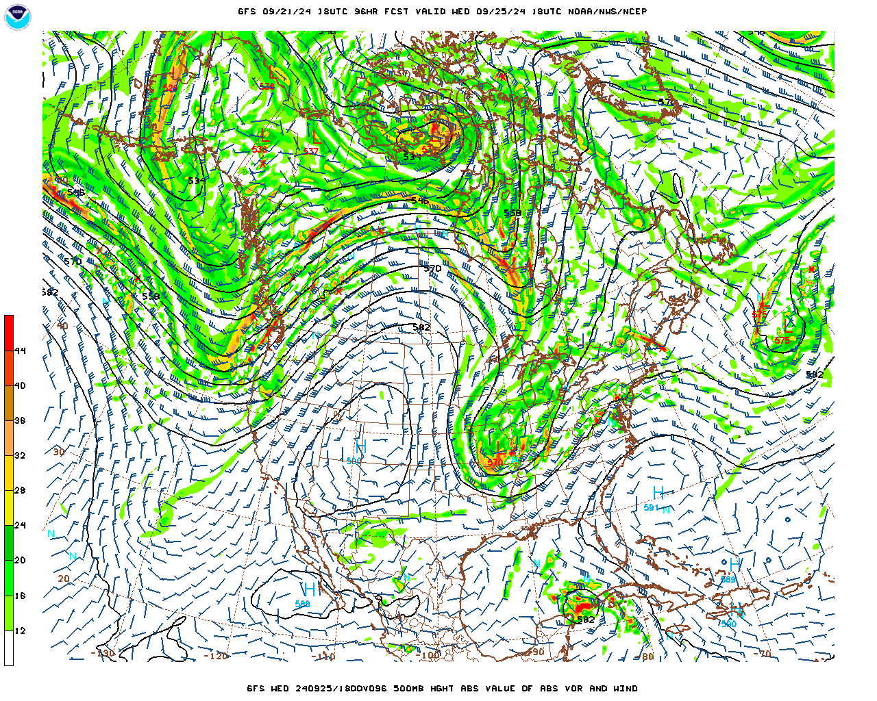

Then on Wednesday, the cold front drops into our region. Meanwhile, a tropical cyclone is trying to form in the Western Caribbean Sea. You can't really count on deterministic model data for the exact details of tropical storms or hurricanes most of the time, and the GFS has been especially notorious over the years for throwing out garbage solutions more often than ones that verify. But models and ensembles have advertised this for several days now, and we do need to pay attention to this. It does not hurt to factor in the GFS solution when considering everything else. Anyway, expecting a High in the lower 80's and Low in the mid-60's on Wednesday around here with about a 30% or about 1-in-3 chance of any one spot getting some of the rain.


I haven't really kept up with it, but I bet the social media alarmists are having a ball with how ominous the GFS makes this hurricane look on Thursday, looks like it is coming for the Florida Panhandle. Please keep in mind that this system has not even formed yet, so even the best computer models (the ECMWF is actually better for this than the GFS . . . even its deterministic output got Hurricane Sandy in 2012 a lot closer to being right than any other model, from what I remember . . . that's the one that hit New England really hard that year) are not working with very good information yet. When an aircraft flies in and finds a defined circulation in a few days, then the models will be a lot more reliable, although again, I'd take them with a grain of salt and NOT focus in on any one solution too much. You either need to look at everything and think it through or rely on the people who get paid to do that 24/7 at the National Hurricane Center.
As the front continues to push through our region on Thursday, rain chances should be about 20-30% with a High in the lower 80's, Low in the lower 60's.


Friday's deterministic model data highlights why you can't get carried away with a model solution. The GFS shows the tropical cyclone already moving through Georgia and into the Carolinas.

Meanwhile, the ECMWF has the hurricane way down there in the Gulf of Mexico. It usually is more reliable at this time range, and for tropical systems. But ideally you'd want to look at its ensembles. And I really don't trust those too much at this point, because the system has not formed yet. So the models are just working on speculation, of what the atmosphere will be like after this thing does form. Confidence is high that it will form, and we'll get to that in just a bit. But at this point, I just think everyone along the Gulf Coast needs to watch it closely. And so do people in Central America. We simply don't know yet where this thing is going or what its intensity will be. We're pretty sure it will form, and conditions are favorable for tropical cyclones to intensify rapidly this time of year, especially this year. We saw that with Hurricane Francine. But if anybody is trying to sell you specifics at this point, please don't buy it. You might as well send your money to that goofy televangelist I saw on the laundromat TV selling some kind of "miracle spring water" . . . well, no, actually that's a worse bunch of malarkey . . . but . . . moving right along . . .
I suspect we'll be dry on Friday, but may keep a 20% chance of rain in there just to be on the safe side. High should be about 80 or so, Low of 60 or so.


And again on Saturday, the model guidance just is not all that reliable.

Even if you wanted to believe the (deterministic) European solution, it is showing major impacts for Mississippi and Alabama from the tropical cyclone. And that is so opposite of what the GFS is showing. The system hasn't even formed yet. And the model guidance at this point is just a big mess.
Will estimate a High of about 80 (could be upper 70's for some of us), Low near 60, a 20% chance of rain at most. May leave rain out of the forecast for next Friday and Saturday. Because even if you leave that minimal chance in just in case we get tropical impacts again . . . that really isn't a great forecast. If we get tropical impacts, I'm not sure the average person is going to care much whether the forecast a week before said mostly sunny or included a tiny chance of rain in there. This is a case where it's better to admit that our confidence in the extended outlook is not very high with this forecast package.


The ECMWF ensemble data shows a good chance of a tropical cyclone forming in the Gulf of Mexico, and this is valid Wednesday through Saturday. I posted each of those four days in order here. You can see where the highest chances of a tropical cyclone are, but you can also see there is quite a spread. Nowhere along the Gulf Coast or in Central America can afford to write this system off, and nobody should be unduly alarmed. Because nobody knows where this thing is going yet. We're still waiting on it to form.

But at some point this week, probably by Thursday, we're likely to see a tropical depression form in the Northwest Caribbean Sea and adjacent parts of the Gulf of Mexico. I have a hunch that it will quickly strengthen to a hurricane, but don't take that to the bank.
I wouldn't worry about that weak disturbance a few hundred miles Southeast of Bermuda.
That tropical wave coming off the coast of Africa may very well becomes a tropical depression as it moves westward this week.

Our rainfall totals should stay under a half-inch, probably under a quarter-inch for most of us . . . unless we see impacts from a tropical storm or hurricane before this week is over. And while that's not immediately likely, we do have to keep an eye on that possibility. We got the remnants of Hurricane Francine. And we'll just have to watch what this one does. It could just as easily hit somewhere else and leave us dry.
We're lucky to have these great computer models and such easy access to the data now. About 20 or 30 years ago, a system like this might have caught people more by surprise. The tradeoff for having more information is that a lot of people don't understand what to do with that extra information. The smart thing is for everybody in Mexico, Central America, and along the Gulf Coast to keep an eye on this. I think we'll see at least a tropical depression by Wednesday or Thursday. If I had to guess, I'd say it'll strengthen to a hurricane somewhere in the Gulf of Mexico. But that's only a guess. And it could end up anywhere from the coast of Louisiana to Florida. There is even a chance something could steer it more toward Central America instead of the Gulf Coast. So it's one of those wait-and-see situations. At least we know something is trying to form in the Northwest Caribbean within the next few days. The drawback is how the general public now gets the information through social media without a lot of context. Of course, kudos to the forecasters who put in the extra time to clarify these things for the average person, for people who are not glued to the weather all the time.
Started to post some general chatter about news items and social issues, but again deferred it for later, because it's hard to know what to zero in on. And one of the videos I linked to had been set to "private", rendering an entire paragraph from a few days ago useless. I really hate this modern trend of people expressing their opinions about as freely as some people let their farts rip. Unless I'm clowning around and just talking off the cuff, if I'm going to throw my opinions out there, I'd prefer that they're well thought-out.
Perhaps I'll go with a balance-point being saying nothing and pontificating.
I guess the main ideas are: We should all condemn assassination attempts on Presidents or former Presidents. Gerald Ford had a similar situation to what Donald Trump has had recently, except it was two crazy women who tried to kill him within a short span of time. Based on what we know right now, looks like two crazy men made the attempts on Trump. If the suspect being held for the second attempt is guilty, I hope justice is served, and swiftly.
And it does not diminish at all my revulsion for the smear campaign against immigrants in Ohio. I have not found one shred of evidence that they are killing people's cats, and I think the people spreading that garbage should be ashamed of themselves - JD Vance, Donald Trump, Elon Musk, and anybody else who has jumped on that bandwagon. It's wrong. There are enough real problems going on without making stuff up. In the same breath, I appreciate people like Erin Glynn and Haley BeMiller from the Columbus Dispatch, as well as people like Rob Rue, the mayor of Springfield, Ohio. Because I see them doing the right things here. Paranoia is something to defuse, not to feed. If I really thought cats were being butchered, I'd be as outraged as anybody. I've had several pets and loved them dearly, especially cats. But this is not fire producing the smoke. This is hot air.
No comments:
Post a Comment