

FORECAST:
Friday (High 70, Low 60): Mostly cloudy and windy. Numerous rain showers are possible throughout the day, becoming more scattered at night.
Saturday (High 72, Low 61): Mostly cloudy and breezy. Widely scattered showers are still possible.
Sunday (High 76, Low 60): Partly to mostly sunny. An isolated shower is still possible in the morning.
EXTENDED OUTLOOK:
Monday (High 80, Low 59): Mostly sunny.
Tuesday (High 81, Low 60): Mostly sunny.
Wednesday (High 78, Low 58): Sunny.
Thursday (High 80, Low 54): Sunny.
READING TEA LEAVES:
Friday October 4th (High 80, Low 56): Mostly sunny.
Saturday October 5th (High 81, Low 58): Mostly sunny.
Sunday October 6th (High 83, Low 60): Mostly sunny.
BEACH FORECAST:
Sunday (High 83, Low 67): Sunny and breezy. Hazardous rip currents.
Monday (High 86, Low 71): Sunny. Breezy.
Tuesday (High 86, Low 70): Sunny. Mild.
Monday through Thursday (Highs ~85, Lows ~70): Mostly sunny.
PRONÓSTICO:
Viernes (Máxima 70, Mínima 60): Mayormente nublado y ventoso. Es posible que haya numerosas lluvias durante el día, que se volverán más dispersas por la noche.
Sábado (Máxima 72, Mínima 61): Mayormente nublado y ventoso. Todavía es posible que haya lluvias dispersas.
Domingo (Máxima 76, Mínima 60): Parcialmente a mayormente soleado. Todavía es posible que haya una lluvia aislada por la mañana.
PERSPECTIVA EXTENDIDA:
Lunes (Máxima 80, Mínima 59): Mayormente soleado.
Martes (Máxima 81, Mínima 60): Mayormente soleado.
Miércoles (Máxima 78, Mínima 58): Soleado.
Jueves (Máxima 80, Mínima 54): Soleado.
LEYENDO LAS HOJAS DE TÉ:
Viernes 4 de Octubre (Máxima 80, Mínima 56): Mayormente soleado.
Sábado 5 de Octubre (Máxima 81, Mínima 58): Mayormente soleado.
Domingo 6 de Octubre (Máxima 83, Mínima 60): Mayormente soleado.
PRONÓSTICO DE LA PLAYA:
Domingo (Máxima 83, Mínima 67): Soleado y ventoso. Corrientes de resaca peligrosas.
Lunes (Máxima 86, Mínima 71): Soleado. Ventoso.
Martes (Máxima 86, Mínima 70): Soleado. Templado.
De Lunes a Jueves (Máxima ~85, Mínima ~70): Mayormente soleado.
NOTES:
SKYWARN classes have been scheduled before the Fall secondary severe weather season gets underway, which is usually the month of November around here. Here is the link for Alabama and also for Tennessee.
DISCUSSION:


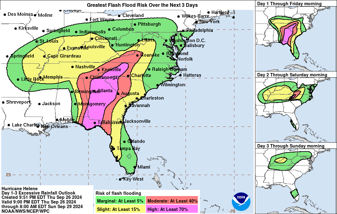
It was a mostly overcast, breezy day with several rounds of light rain in the Tennessee Valley. We do have a Flash Flood Watch and Wind Advisory in effect despite being on the "good" West side of Hurricane Helene. Gotta' say, I feel for the people in Southern Georgia and the Big Bend of Florida who have to suffer the direct path of this particular storm. They won't be using the name Helene for a hurricane again. This is one for the books, to be studied in the future. It's really something for the Florida Bend to have two such significant hurricanes in such a short time. They just had Hurricane Idalia last year.
We also had periods of fog up this way today. The High in Cullman was 79, and the Low was 64. Jasper also had a High of 79 and Low of 64. Haleyville saw a High of 80 and Low of 61. Huntsville had a High of 83 and Low of 64. Nashville had a High of 82 and Low of 63. We did see some sun early today, but in the afternoon and evening, the rain and clouds really took over. So we got warmer than forecast before the rain came in.
Definitely an anomalous look to the weather right now, where on the upper-air 500 millibar (about 18,000 feet) map, you can see those two upper-level Lows doing the Fujiwhara effect. Well, actually, even though I heard Marshall Shepherd and James Spann both use the term, as well as a forecaster from NWS Birmingham (Matt Grantham I think?), the Associated Press is saying that's technically not right. I'm not sure if I care about being that nitpicky. This is really neat to see play out, with two low pressure systems, one of them a major hurricane, moving in opposite directions before they merge together.


This is one fast-moving system, and by tomorrow afternoon, the two systems should be merged up in Tennessee.

We're not worried about severe weather around here, tornadoes spinning up. That threat will stay to the East of the hurricane remnants, mainly in the Carolinas but also affecting Virginia. Just some gusty winds around here and plenty of rain, low risk for some flash flooding issues because of so much rainfall. But we are on the West side of this tropical cyclone that's going to get absorbed into the other low pressure system that's been associated with the front that brought us some rain earlier in the week.
Rain should gradually be tapering off tomorrow (meaning Friday . . . it's technically after Midnight as I write this so technically could say "today", but going to call it "tomorrow"), but overall anywhere has about a 50/50 at a shower throughout the day, maybe dropping to 30-40% chance at night. And it will be breezy, some gusty winds at times, thus the wind advisory in effect. High near 70, Low near 60.


On Saturday, the rain should be widely scattered, about a 1-in-3 chance of any one spot getting a shower, but we'll still see mostly cloudy skies and breezy conditions, some high wind gusts, up to about 20 mph anyway. High in the lower 70's, Low near 60.


Drier air starts to move in here on Sunday, although the GFS is now showing on the latest run, some moisture trying to linger with that dying Low pressure system.

I think the ECMWF is more accurate in moving that moisture well to our North. If I keep a rain chance in for Sunday, it will only be the minimal 20% of something really isolated hanging around. High should get up into the mid-70's again, Low near 60.


The GFS shows spotty rain in Tennessee on Monday, but again I think it's overdoing things. Certainly for here in North Alabama, Cullman County, just going to mention mostly sunny skies, maybe some fog hanging around in the morning, High near 80, Low near 60, many places may dip into upper 50's already. And that's going to start our first real taste of Fall weather this year.


By Tuesday the GFS model is starting to smell the coffee. We have high pressure moving in, mostly sunny skies, High near 80, Low near 60. Again would not be surprised to see upper 50's for Lows in some places.


Then for Wednesday we get a reinforcing shot of cool, dry air, sunny skies with the High struggling to reach 80 degrees, the Low dipping into upper 50's.


And on Thursday of next week, sunny skies with a High near 80, Low in mid-50's, really dry airmass in place.
Do we dare to peek beyond seven days? Yes, yes we do.


Next Friday, we can discount that tropical system the GFS wants to form in the Gulf.

Because we do not have agreement from the ECMWF. But the local forecast up this way is still valid. The models just tend to go on wild goose chases during the heart of hurricane season, especially the GFS. Those rarely verify.
This would mean a mostly sunny day, High near 80, Low in the mid-to-upper-50's.


Again, I don't think that tropical system in the Gulf is going to happen, think the model is having one of its usual hiccups like that. Around here expecting mostly sunny skies, High of 80 or so, Low in the upper 50's.


Then on Sunday, mostly sunny skies again, High in lower 80's, Low near 60.
I don't buy that scenario of the hurricane in the Gulf from the GFS.

The only caveat I'll throw in there is that the ECMWF does also develop a tropical cyclone in this same time frame, same basic time frame (Days 7-10) but moves it toward Mexico instead of up toward the Gulf Coast. So there may be some truth to that basic idea. But look, this is the prime time of the year to have a Gulf hurricane. We've got record-warm water temperatures this year. So I wouldn't get worried about any specific model run, just stay aware in case we do have any more problems. The forecasts for Hurricane Helene were excellent. The models, including tropical models, had a pretty good handle on what it was going to do while it was still down in the Caribbean Sea, before it had even become a tropical storm, was just this broad area of disorganized low pressure. So if anything does look concerning, you'll hear about it from the National Hurricane Center, no need to trip out over model runs 7-10 days in advance. This does make me wonder if another Gulf storm will form within the next 10 days, but that's about as much as I'm wondering about. If anything does form, the main two global models are not on the same page as to its path at all. And it may not even form at all during this time period.


So let's look at the latest from the National Hurricane Center.
And they are actually noticing the potential for an area of low pressure forming in the Caribbean by midweek, with potential for slow development, and moving into the Gulf of Mexico by the end of this next week. So that is what the GFS and ECMWF are picking up on. The GFS just got way too aggressive with it. It is a reasonable thing to keep an eye on, but nothing to get unnecessarily worried about. If there is anything to worry about, you can be sure the forecasts will start to reflect it. Be careful about believing too much of what you see on social media about it. People tend to like to post the worst-case scenarios. As one lady who follows me on Twitter/X kept saying, there were some idiots predicting a Category 6 hurricane for Florida with Helene. Which ended up being a Category 4. A Category 6, of course, does not even exist . . .
That area highlighted in red is about to become a tropical storm (or at least depression) between the Cabo Verde Islands and Lesser Antilles. It is moving West/Northwest at 10-15 miles per hour.


Then we do have Tropical Storm Isaac, expected to strengthen to a hurricane and then weaken back to a tropical storm over the next several days, staying out at sea.


No comments:
Post a Comment