FORECAST:
Wednesday (High 75, Low 65): Rain showers likely through the day and night. An isolated thunderstorm is possible.
Thursday (High 74, Low 63): Rainy. Breezy.
Friday (High 72, Low 61): Mostly cloudy, breezy at times. Numerous rounds of showers are still possible.
EXTENDED OUTLOOK:
Saturday (High 79, Low 60): Mostly sunny with a 20% chance of a shower.
Sunday (High 80, Low 60): Mostly sunny with a 20% chance of showers.
Monday (High 81, Low 60): Mostly sunny with a 20% chance of showers.
Tuesday (High 82, Low 59): Mostly sunny.
BEACH FORECAST (GULF SHORES AND NEARBY - ALABAMA COAST):
Wednesday (High 86, Low 73): Thunderstorms likely. Dangerous rip currents expected.
Thursday (High 82, Low 71): Breezy with rain showers likely. Dangerous rip currents.
Friday (High 82, Low 69): Sunny. Rip currents still hazardous.
PRONÓSTICO:
Miércoles (Máxima 75, Mínima 65): Lluvias probables durante el día y la noche. Es posible una tormenta aislada.
Jueves (Máxima 74, Mínima 63): Lluvioso. Ventoso.
Viernes (Máxima 72, Mínima 61): Mayormente nublado, ventoso a veces. Aún son posibles numerosas rondas de lluvias.
PERSPECTIVA EXTENDIDA:
Sábado (Máxima 79, Mínima 60): Mayormente soleado con un 20 % de probabilidad de lluvias.
Domingo (Máxima 80, Mínima 60): Mayormente soleado con un 20 % de probabilidad de lluvias.
Lunes (Máxima 81, Mínima 60): Mayormente soleado con un 20 % de probabilidad de lluvias.
Martes (Máxima 82, Mínima 59): Mayormente soleado.
PRONÓSTICO DE PLAYAS (GOLF SHORES Y CERCANAS - COSTA DE ALABAMA):
Miércoles (Máxima 86, Mínima 73): Probabilidad de tormentas eléctricas. Se esperan corrientes de resaca peligrosas.
Jueves (Máxima 82, Mínima 71): Ventoso con probabilidad de lluvias. Corrientes de resaca peligrosas.
Viernes (Máxima 82, Mínima 69): Soleado. Las corrientes de resaca siguen siendo peligrosas.
NOTES:
Anybody in or near the path of this hurricane needs to put their safety plan into action before the weather begins to deteriorate.
The National Weather Service in Birmingham is holding SKYWARN classes before we get into the month of November, which sometimes becomes sort of a secondary severe weather season around here, main one being in the Spring months. If you're in Tennessee, the NWS Nashville is also holding classes, online and in-person. For anybody who has never taken one, I just want to mention that they are free.
DISCUSSION:
Clouds increased, and we got breezy in the Tennessee Valley today, especially this evening and in the dark hours. And there were several showers and thunderstorms, especially in Middle Tennessee. Some became severe. The storm that came through Cullman and Morgan Counties earlier stayed below severe limits but did show some signs of producing wind gusts up to 40 miles per hour. The High in Cullman today was 88, and the Low was 66. In Jasper the High was 90 with a Low of 66. Haleyville saw a High of 87 and Low of 69.
Huntsville got up to 91 degrees after a Low of 70. And Nashville, which got a lot of periods of rain today, saw a High of 87, and its current temperature of 70 is the Low so far for today. It's 8:10 PM. If you want to count this morning's temperature as the Low, the lowest they got was 73.
At this point, the showers and thunderstorms over the Southeast region have formed into two lines, neither of which is producing severe winds anymore.
We did have some damaging wind reports out of this system, a few close to home. Near Byrd in Marion County, a few trees came down. The most notable one was in Lawrence County, Tennessee, just across the border there, in the town of Ethridge, where some power lines came down, some structures lost roofing, and a tent collapsed. Three people were injured in the tent collapse, fortunately no others reported in that damaging thunderstorm. Also in Marion County (Alabama), a tree reported down on Silk Street in Hamilton.
The main two players in our weather for this forecast are going to be that cold front that brought us the scattered but strong thunderstorms, sometimes even severe thunderstorms, earlier today. And the other player in our weather is going to be Hurricane Helene in a strange way. As I'm writing this, it is still Tropical Storm Helene. But by some time tomorrow, it will be to hurricane strength. And is expected to become a major hurricane by the time of landfall Thursday evening or night, worst impacts expected in the Big Bend of Florida.
Tomorrow just looks rainy from the cold front. High should be about 75, Low tonight/in the morning about 65.
Not concerned with any more severe thunderstorms up this way tomorrow, with the air so cool and stable compared to today's. Even in far Southern Alabama into Florida, the risk of storms becoming severe is low.


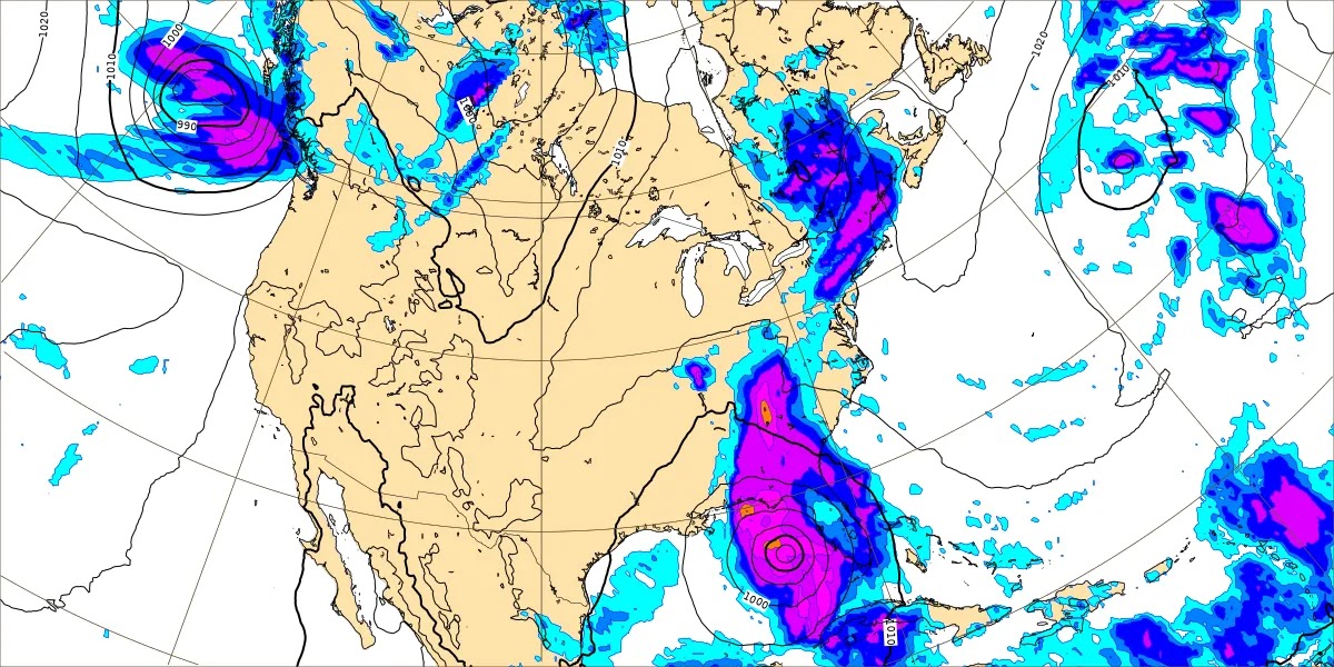
On Thursday the GFS has started to pick up on this trend that the ECMWF was showing even a day or two ago, called the Fujiwhara Effect, where we'll have two low pressure systems circling each other in a weird way, moving in opposite directions to our West and to our East. The one to our West is the one associated with the cold front, and the one to our East (or definitely Southeast during the daylight hours) is the tropical cyclone we will soon know as Hurricane Helene. And Thursday looks like another really rainy day. Winds will also be picking up Thursday and Thursday night, even though we are on the West side of the hurricane. It is the East side of a hurricane that gets the really bad weather, including tornadoes spinning up in those spiral bands. We'll still get a lot of rain on the West side of this though, expected to be a big storm that covers a lot of ground. The winds probably won't be as bad as they were with Hurricane Francine, we'll likely stay below Wind Advisory criteria. But it could still be common to have winds gusting between about 20-30 miles per hour much of Thursday and Thursday night around here. Looking at a High about 73-75 and a Low about 61-63.
And it's amazing how much agreement we have between the forecast models on this hurricane. This is the GFS above.
This is the NAM, a mesoscale (rather than global) model.
Back to global models, here is the European ECMWF, the one I've seen get tropical systems right when the other deterministic models were out to lunch sometimes, most notably with Hurricane Sandy in 2012. This time, it looks like all these models are basically on the same page, which is the same page the tropical models are on. Confidence is high now in this hitting the Florida Bend.
Now these are valid at 1 PM going into Thursday afternoon. Weather conditions there will already be deteriorating rather badly by that time, but the actual landfall of the eyewall of this hurricane is expected Thursday evening or night. This looks like it is going to be a big hurricane that packs a punch.
Then on Friday, the two low pressure systems try to merge to our North/Northwest. Looks like we stay mostly cloudy, but will bring rain chance down to 50%, we'll stay sort of breezy.
By the way, we are not expecting any tornado threat from this system, since we will be on the Western side of the tropical cyclone. We would have that concern if we were on the East side of it.
High should be in the lower 70's, Low in the lower 60's.
Then we may get a break in the rain on Saturday, but I'm going to keep a 20% chance in there for that minimal possibility of something isolated hanging around. High should rebound to about 80, Low near 60.
The weather looks similar for Sunday.
And basically the same thing Monday, High near 80, Low near 60, mostly sunny skies, that outside 20% chance of a passing shower.
And the weather looks similar for Tuesday October 1st, but here I agree with the GFS in dropping the rain chances by then.
And
Hurricane Helene looks like it is going to be a serious situation for the Florida Bend. The current forecast from the National Hurricane Center calls for winds sustained at 100 knots/115 miles per hour before this thing makes landfall. That would make it a "Category 3" on the Saffir-Simpson Scale, but I wouldn't get too hung up on nitpicky details like that. The bottom line is that this is expected to be a major hurricane capable of significant impacts, that will cover a large area. Ground zero for this one is the Big Bend of Florida, but the impacts can be felt to an extent far beyond the eyewall, mainly along the East and Northeast side of the storm.


Storm Surge could be a big deal with this one along the coast. Parts of Florida have already
started evacuating people ahead of this. Obviously flooding is a major concern, and that includes for Georgia. This thing is going to move fast, and even places like Atlanta could see tropical storm conditions, if not hurricane conditions. Marshall Shepherd
wrote a piece about that earlier today. And at least Eastern Georgia into South Carolina and of course down into the Florida Peninsula will have a threat for isolated tornadoes on Thursday. They will be on that East/Northeast side of the eyewall.
So this looks like a nasty hurricane. I wouldn't worry about just how bad it's going to be, other than taking stock of the specific hazards for your area. The main thing is to protect yourself and loved ones if you are in or near the direct path of this. If you get an evacuation order, follow it to the best of your ability. I know it's not always easy, but this is a case where people need to put safety first and convenience on the back burner. This is likely to be a hurricane with significant impacts.
It doesn't look bad for North Alabama or Southern Middle Tennessee, but we could see rainfall totals up to 4-5 inches for this forecast period. And scattered instances of flash flooding are a possibility. We'll have gusty winds at times or at least breezy conditions, but we are not worried about severe weather with this. Because we are staying on the West side of it.
And it isn't just Ohio having to deal with overblown (or sometimes outright fabricated) stories about immigrants causing problems. The mayor of Fairhope, Alabama
had to debunk rumors at a recent meeting, because a lot of people showed up thinking there was a big flood of immigrants coming to Alabama . . . and it was a lot of hot air.
What can I say . . . paranoid scenarios usually are.
Once in a while, I feel like calling out bullshit for what it is, and not just weather hyperbole.


No comments:
Post a Comment