

FORECAST:
Friday (High 93, Low 71): Partly cloudy with scattered showers and thunderstorms possible, mainly in the evening hours. Some thunderstorms could produce strong winds and heavy rainfall.
Saturday (High 91, Low 71): Mostly cloudy with numerous showers and thunderstorms possible, mainly in the afternoon and evening hours. Some thunderstorms could produce strong winds and heavy rainfall.
Sunday (High 89, Low 70): Partly to mostly sunny. Lingering isolated showers/thunderstorms are possible, mainly in the morning.
EXTENDED OUTLOOK:
Monday (High 85, Low 66): Sunny.
Tuesday (High 84, Low 62): Sunny.
Wednesday (High 87, Low 59): Sunny.
Thursday (High 90, Low 65): Mostly sunny.
BEACH FORECAST:
Friday (High 91, Low 78): Partly cloudy. Scattered showers and thunderstorms are possible.
Saturday (High 93, Low 76): Partly to mostly sunny. Isolated showers and thunderstorms are possible.
Sunday (High 93, Low 78): Partly cloudy. Scattered showers and thunderstorms are possible.
PRONÓSTICO:
Viernes (Máxima 93, Mínima 71): Parcialmente nublado con posibles lluvias y tormentas eléctricas dispersas, principalmente en las horas de la tarde. Algunas tormentas podrían producir fuertes vientos y fuertes lluvias.
Sábado (Máxima 91, Mínima 71): Mayormente nublado con numerosos aguaceros y tormentas eléctricas posibles, principalmente en las horas de la tarde y la noche. Algunas tormentas podrían producir fuertes vientos y fuertes lluvias.
Domingo (Máxima 89, Mínima 70): Parcialmente a mayormente soleado. Es posible que persistan lluvias/tormentas aisladas, principalmente por la mañana.
PERSPECTIVA EXTENDIDA:
Lunes (Máxima 85, Mínima 66): Soleado.
Martes (Máxima 84, Mínima 62): Soleado.
Miércoles (Máxima 87, Mínima 59): Soleado.
Jueves (Máxima 90, Mínima 65): Mayormente soleado.
PRONÓSTICO DE LA PLAYA:
Viernes (Máxima 91, Mínima 78): Parcialmente nublado. Es posible que se produzcan lluvias y tormentas aisladas.
Sábado (Máxima 93, Mínima 76): Parcialmente o mayormente soleado. Es posible que se produzcan chubascos y tormentas aisladas.
Domingo (Máxima 93, Mínima 78): Parcialmente nublado. Es posible que se produzcan lluvias y tormentas aisladas.


At 2 PM it is mostly sunny in Cullman with a temperature of 91 degrees. The dewpoint is 70 degrees, making the relative humidity 49%. The heat index is 97 degrees. Winds are calm. The pressure is 30.05 inches and falling slowly.
It is mostly cloudy and 95 degrees in Jasper. Overcast and 91 in Haleyville. Partly cloudy and 93 in Huntsville. Mostly cloudy and 94 in Nashville.
Many of us are under a heat advisory, definitely in Cullman and Huntsville. That means heat indices could get to 105 or greater before the day is through.
Although walking with a friend last night, he commented on the lower humidity lately and how you could tell Fall was coming even though it was still a lot of hot days. And I can feel that in the air too. I just wish it would hurry up.
Our high pressure is going to retrograde to the West and put us in a favorable position to get the leftovers of whatever storms form out that may, mainly in Missouri and Arkansas. At some point nearly every summer, we have to watch for those - called "mesoscale convective systems" - in the Northwest wind flow aloft. They don't always stay really strong, much less at severe limits, by the time the rain and thunderstorms get down this way. But sometimes they do. And one of those can get here during the daylight hours or at night. Those storm clusters pose a risk for hail or damaging winds.
But a lot of times, the leftovers we get are just regular thunderstorms or beneficial rain. Want to make that clear too. If you've lived around here long, you probably know how the storms of summer go.


Most of tomorrow should stay dry. We'll see a High in the lower 90's, 93 is a good estimate.

But in the evening we may see one of those MCS coming from probably Missouri.

The Storm Prediction Center does have us outlooked for a 5% marginal threat of damaging winds with thunderstorms. They are not concerned with any significant large hail threat.
So to put it in simple language, most of tomorrow will just be a hot summer day, but then at some point in the evening, some of us may get a cluster of thunderstorms. And if they sustain from our Northwest as they move into our region, they could have enough wind to damage some trees or power lines where they are strongest. High of about 93, Low of 70-71 tomorrow.
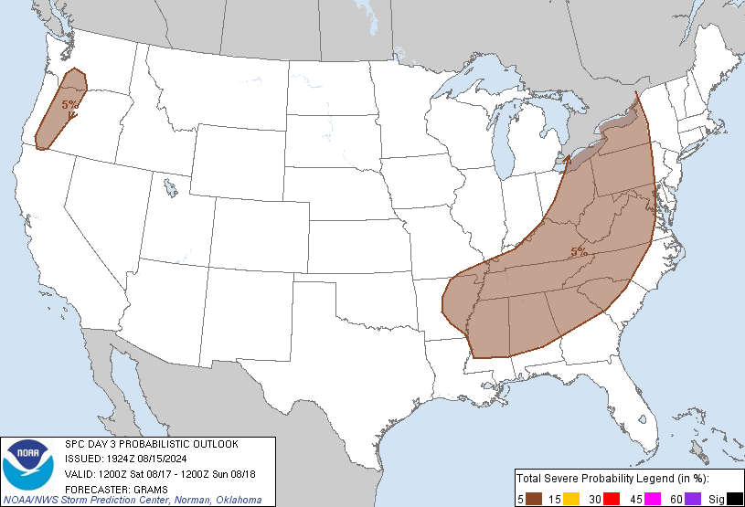
Again on Saturday the SPC has that 5% marginal chance of a few thunderstorms being able to reach severe limits.


Most of the day should stay dry though. For now I'm forecasting a 40% chance of rain for both tomorrow and Saturday. Will adjust that later if needed after looking back over the 7-10 day pattern. It's a close call, but the High on Saturday may be closer to 90 again with more cloud cover and possibility of getting rain in time to interrupt some of the afternoon heat.

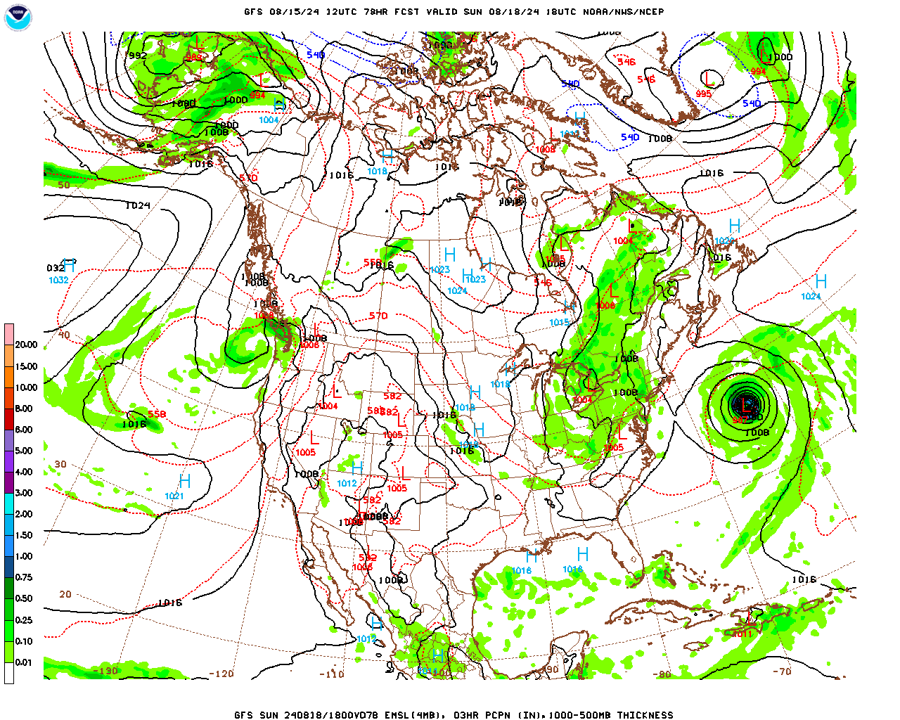
Then on Sunday it looks like we'll get a cold frontal passage, at least by the evening.

And we could still see some isolated rain Sunday, but if so, probably in the morning, left over. Our cold fronts this time of year tend not to be all that spectacular, and we'll likely still see a High close to 90, Low near 70 for Sunday.
Thinking the best rain chances might be 30-40% for Friday, 50% for Saturday, then trim to 20% for Sunday.


Then starting Monday, that strong northerly wind flow will start to bring us a shot of milder, drier air.
Skies should be sunny Monday with a High in the mid-80's, Low in the mid-60's.


Tuesday looks similar except that the Low could actually dip into the lower 60's. Humidity levels will be really low, so this might be a good time to get some yard work done.


Wednesday the air stays very dry. We could start the day near 60 degrees, even upper 50's for some of our cooler pockets, especially up into Tennessee. And then only warm to mid/upper 80's in afternoon. Skies should stay sunny.


Then a week from today, Thursday, looks mostly sunny with a High back close to 90, Low in the 60's.


Then if you want to look out 10 days, next Friday through Sunday look like a return to a typical summer pattern, will reintroduce a 20% chance of rain even though high pressure will keep most of us dry most of the time. Highs near 90, Low near 70.


Hurricane Ernesto is heading for the Island of Bermuda, which has dealt with quite a few hurricanes over the years and has good plans in place to protect residents and tourists. It did some damage in Puerto Rico while it was still at tropical storm strength.


There is a low risk of flash flooding issues with any MCS that we deal with over the next few days.

But overall our rainfall totals should average up to about an inch over the next 7-10 days. Many of these days will be dry and milder than we've had in a while.
Congratulations to Ms. Meaghan Thomas for working in Alabama again. Maybe that whole thing about getting complaints about her kneecaps not looking professional (at least I think that was the complaint . . . . it was so bizarre, I just remember laughing about it) was only a Tennessee thing. Although I doubt it. She'll probably have a bunch of idiots call that station on Red Mountain for one thing or another. But hey, we're glad to have her back. Even you idiots reading this who like to complain about kneecaps, you gotta' admit she does a good job. So give her a warm welcome. And if you have to complain about something, make it more creative than that. Or we deserve to lose to Tennessee with Nick Saban gone anyhow.
And I'm outta' here before I say something even more cringe. It's intentional, I promise.
P.S. My kneecaps are very sexy. Private pictures are available . . . oh wait, already sold out . . . guess you'll have to call and badger the TV people after all.
For anybody who cares enough to read all the way through, on a not-joking note, this Saturday is the 55th anniversary of Hurricane Camille in 1969.


No comments:
Post a Comment