FORECAST:
Sunday (High 90, Low 69): Patchy fog possible in the morning. Otherwise sunny.
Monday (High 91, Low 70): Sunny.
Tuesday (High 93, Low 71): Sunny.
EXTENDED OUTLOOK:
Wednesday (High 95, Low 73): Mostly sunny.
Thursday (High 92, Low 72): Partly cloudy.
Friday (High 89, Low 70): Partly to mostly cloudy.
Saturday (High 88, Low 68): Partly to mostly cloudy.
BEACH FORECAST:
Sunday (High 92, Low 79): Showers and thunderstorms likely.
Monday (High 92, Low 78): Partly cloudy with a 40% chance of scattered showers/thunderstorms.
Tuesday (High 94, Low 80): Partly cloudy with a 30% chance of widely scattered showers/thunderstorms.
Rest of Week (Highs in lower 90's, Lows in lower 80's): Partly cloudy with a 20% chance of isolated showers/thunderstorms.
PRONÓSTICO:
Domingo (Máxima 90, Mínima 69): Posible niebla irregular en la mañana. Por lo demás soleado.
Lunes (Máxima 91, Mínima 70): Soleado.
Martes (Máxima 93, Mínima 71): Soleado.
PERSPECTIVA EXTENDIDA:
Miércoles (Máxima 95, Mínima 73): Mayormente soleado.
Jueves (Máxima 92, Mínima 72): Parcialmente nublado.
Viernes (Máxima 89, Mínima 70): Parcialmente a mayormente nublado.
Sábado (Máxima 88, Mínima 68): Parcialmente a mayormente nublado.
PREVISIÓN DE LA PLAYA:
Domingo (Máxima 92, Mínima 79): Lluvias y tormentas eléctricas probables.
Lunes (Máxima 92, Mínima 78): Parcialmente nublado con un 40 % de probabilidad de lluvias/tormentas eléctricas dispersas.
Martes (Máxima 94, Mínima 80): Parcialmente nublado con un 30% de probabilidad de lluvias/tormentas eléctricas ampliamente dispersas.
Resto de la Semana (Máximas en los 90 grados inferiores, Mínimas en los 80 grados inferiores): Parcialmente nublado con un 20 % de probabilidad de lluvias/tormentas eléctricas aisladas.
NOTES:
There was a microburst in Marshall County yesterday that mainly affected the town of Honeycomb and did some structural damage as well as tree damage. No one was injured.
This past Monday also got stormy in Northeast Alabama up into Middle Tennessee, and along with damaging thunderstorm winds, Murfreesboro also had a relatively weak tornado near the campus of MTSU.
On the lighter side, our drought conditions have improved a lot since that rainy week we had recently.
And if you're headed to the beach, here are some reminders about rip currents.
DISCUSSION:
Skies have been mostly sunny in the Tennessee Valley today. We had some fog this morning, early. The High in Cullman only made it up to 86 after a morning Low of 70. Jasper saw a High of 91 and Low of 70, which was closer to the forecast. Haleyville was similar, High of 88 and Low of 70. Then peeking up North a bit, Huntsville had a High of 90 and Low of 72. And Nashville had a High of 91, Low of 72.
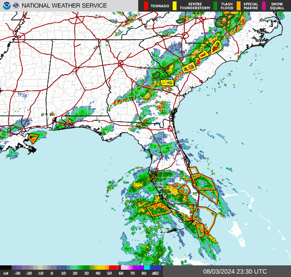
So we've got two main things on the board, the cold front that just passed through our region and is now down along the Gulf Coast, which has brought us a nice, milder day today. And then we have Tropical Storm Debby, which is expected to reach hurricane strength by the time of landfall tomorrow night. Latest model guidance and observations make it look most likely to hit the Florida Bend, where the Peninsula and the Panhandle meet.
Tomorrow should be similar, a sunny day with a High near 90, Low near 69, might see a little fog in the morning again.
Then Monday sunny skies still, we stay on the dry side of Tropical Cyclone Debby. High should be near 90 or so, Low near 70.
Tuesday should be another sunny day with a High in the lower 90's, Low of about 70 or so.
Then on Wednesday we're still on the Eastern edge of that upper-level ridge that's back over the Plains. Expecting a High in the mid-90's and Low in the lower 70's.
By Thursday that tropical cyclone is close enough that even though we're on the West side of it, it could at least bring us some clouds back, at least high-level clouds, as one NWS forecasters noted today. And our position relative to the tropical system should also keep our humidity levels down, so even Wednesday with temperatures around 95 degrees, it won't feel like the 95 degrees we've had several other times this year. For Thursday it looks more like a High back in the lower 90's, Low in the lower 70's.
Friday the GFS wants to move the cyclone westward and bring us a good bit of moisture here.
While the ECMWF continues to move it up the Atlantic seaboard with no hint of it producing any rain around here.
The European model tends to do better at this time range this time of year. And I've also seen it do better with some hurricanes than any other model on the planet. So I'm mainly going to defer to it for this forecast.
But the American model may be picking up on an idea that could partially verify. I doubt we see any rain Friday, but will mention an increase in clouds. And the High should be more toward the upper 80's instead of lower 90's, Low near 70.
Even the GFS keeps any significant rain chances to our East and South next Saturday. I guess technically you can have rain any summer day just randomly around here, but overall our rain chances this forecast period look slim to none.
Of course the heavy rains (and possible flooding issues, storm surge) will be along and East of the hurricane or tropical storm now called Debby. So let's look at that before we wrap up.

What a difference a day can make with the record warm ocean temperatures we have this year. Tropical Storm Debby, which was still a tropical depression about Midnight or so last night, when I posted another forecast, is now expected to reach hurricane strength before landfall. Landfall should happen tomorrow night or during the day Monday. And the most likely place for landfall of the eyewall is the Florida Bend, a place that rarely gets hurricanes. They did get Idalia, think that was last year, and this one is not showing signs of becoming anywhere near that strong. It will likely be a minimal hurricane with winds of about 75 mph or so. Its movement once inland may be sort of slow though, and there is a real concern for flooding and storm surge for areas even outside the Hurricane Warning. Those parts of Florida (basically the West side of the Peninsula) under a Tropical Storm Warning may have winds below hurricane force, but I would still take precautions against potential storm surge or flooding issues.
The exact track has proven tough to nail down, but the remnants will probably end up in the Carolinas by Wednesday or Thursday. It may have a little time to restrengthen over water, but that is dicey. And the current NHC forecast does not show it strengthening back above tropical storm force after passing over the Florida land.
The main concern I have, well any hurricane is dangerous, and you can even have tornadoes spin up (especially in the Northeast quadrant of the spiral bands). But the main concern I have with this one is people getting flooded, whether that's by storm surge or by just a lot of rainfall in the space of a day or two. I believe Hurricane Beryl was down to a Category 1 storm by the time it hit Texas earlier this summer. And they still had some problems. So this isn't a major hurricane like Idalia or Ian, but I'd still encourage residents to take it seriously. If you live down there, you know what reasonable precautions to take against tropical storm or hurricane force winds, and also against flooding events.
No significant impacts to Alabama or Tennessee, but just throwing in a word for these other folks since our weather is boring around here.
Extremely challenging circumstances lately, had a suicide in my extended family, and this poor guy was only 17 years old, about to start his last year of high school. I started to write a lot about it, but look, I'm not getting paid to write a newspaper column here. It's a brutal situation, I'll say that, and I am having a hard time finding a silver lining to this particular cloud. If you can find ways to remind yourself and those you love why life is valuable, more power to you. I sure wish we collectively made it feel more valuable to people who suffer the most. A lot of them do so privately, and that was the case here. I never had a clue this guy was depressed. But I rarely saw him, just once every few years, and heard anecdotes about him and his sister from other people. I'm not sure how this will affect what I'm doing here. I wrote this forecast discussion to distract my mind into some cold, hard logic and try to stop thinking about the bad stuff. A hurricane is nothing compared to the other. But if I do post a lot in the near future, I suspect that the quality of my "work" here will suffer from the situation. I made a special effort tonight not to let it. But I may have made some mistakes simply because I have more the temperament of an artist than a scientist. This guy was interested in weather the last time I saw him, and he never knew that I dropped out of school for meteorology mainly because of depression. They just told him i was the go-to guy for weather, his mother and his aunt. I was ashamed of that and didn't mention to him. Little did I know his depression was worse than mine, to the point . . . he's gone now. I tried to write a poem about the situation earlier today, and maybe I should get back to that. Venting online is a terrible habit, even if almost everyone does it now.
Don't sweat the weather around here, even the heat doesn't look as bad as many times earlier this summer, but you might want to make sure any people you know in Florida know what's up.


No comments:
Post a Comment