

FORECAST:
Sunday (High 97, Low 70): Mostly sunny. Hot.
Monday (High 96, Low 72): Partly cloudy and staying hot. Isolated showers and thunderstorms are possible.
Tuesday (High 95, Low 73): Partly cloudy and staying hot. Widely scattered showers and thunderstorms are possible.
EXTENDED OUTLOOK:
Wednesday (High 93, Low 73): Partly to mostly cloudy with a 40% chance of showers/thunderstorms.
Thursday (High 88, Low 72): Mostly cloudy with a 50% chance of showers/thunderstorms.
Friday (High 88, Low 69): Partly to mostly cloudy with a 40% chance of showers/thunderstorms.
Saturday (High 89, Low 70): Partly to mostly cloudy with a 40% chance of showers/thunderstorms.
BEACH FORECAST:
Sunday (High 91, Low 77): Partly cloudy. Scattered showers and thunderstorms are possible.
Monday (High 92, Low 78): Partly cloudy. Scattered showers and thunderstorms are possible.
Tuesday (High 92, Low 78): Partly cloudy. Scattered showers and thunderstorms are possible.
Wednesday through Weekend (Highs in lower 90's, Lows in upper 70's): Partly to mostly cloudy with a 50% chance of showers/thunderstorms.
PRONÓSTICO:
Domingo (Máxima 97, Mínima 70): Mayormente soleado. Caliente.
Lunes (Máxima 96, Mínima 72): Parcialmente nublado y caluroso. Es posible que se produzcan chubascos y tormentas aisladas.
Martes (Máxima 95, Mínima 73): Parcialmente nublado y caluroso. Es posible que se produzcan lluvias y tormentas eléctricas ampliamente dispersas.
PERSPECTIVA EXTENDIDA:
Miércoles (Máxima 93, Mínima 73): Parcialmente a mayormente nublado con un 40% de probabilidad de lluvias/tormentas eléctricas.
Jueves (Máxima 88, Mínima 72): Mayormente nublado con un 50 % de probabilidad de lluvias/tormentas eléctricas.
Viernes (Máxima 88, Mínima 69): Parcialmente a mayormente nublado con un 40 % de probabilidad de lluvias/tormentas eléctricas.
Sábado (Máxima 89, Mínima 70): Parcialmente a mayormente nublado con un 40% de probabilidad de lluvias/tormentas eléctricas.
PREVISIÓN DE LA PLAYA:
Domingo (Máxima 91, Mínima 77): Parcialmente nublado. Es posible que se produzcan lluvias y tormentas aisladas.
Lunes (Máxima 92, Mínima 78): Parcialmente nublado. Es posible que se produzcan lluvias y tormentas aisladas.
Martes (Máxima 92, Mínima 78): Parcialmente nublado. Es posible que se produzcan lluvias y tormentas aisladas.
De Miércoles a Fin de Semana (Máximas en los 90 grados inferiores, Mínimas en los 70 superiores): Parcialmente a mayormente nublado con un 50 % de probabilidad de lluvias/tormentas eléctricas.
We have rapidly gone into a state of drought around here.
DISCUSSION:
At 2 PM skies are mostly sunny in Cullman. The temperature is 93 degrees. The dewpoint-temperature is 64 degrees, making the relative humidity 39%. So the heat index is only 95 degrees. Winds are calm. Barometric pressure is 30.20 inches and falling slowly at the moment. The Low temperature this morning was 66.
Skies are fair in Jasper with a temperature of 99 degrees. The dewpoint is 59, making the relative humidity 27%. Winds are variable at 5 miles per hour. The pressure is 30.16 inches and steady. This morning's Low was 66.
It is partly cloudy and 96 degrees in Haleyville. The dewpoint is 64, making the relative humidity 35%. Winds are variable at 7 mph. The pressure is 30.21 inches/1021.2 millibars and falling slowly. The Low this morning was 68.
Huntsville is mostly cloudy and 96 degrees. The dewpoint is 65, making the relative humidity 36%. Winds are calm. The pressure is 30.17 inches/1020.6 millibars and falling slowly. This morning's Low temperature was 72.
Then finally Nashville is mostly sunny and 97 degrees at this hour. The dewpoint is 62 degrees, making the relative humidity 32%. Winds are from the North at 8 mph with higher gusts up to 25 mph. The pressure is 30.19 inches/1021.4 millibars and falling slowly at the moment. But like a lot of sites, the pressure has been waffling up and down today, as it often does in the summer months. The Low temperature for the Music City was 73 this morning.


We're seeing some rain showers to break up the heat a little, but they are staying pretty isolated.


Got some thunderstorms along the Gulf Coast and into Florida, also up in the Carolinas from that weak tropical wave that has moved inland from the Atlantic. Also got some thunderstorms up in the Ohio Valley. Of course we could see some thunder around here, but for the moment, the few radar echoes we have are just showing rain. And there isn't much of it. Satellite mainly showing fair-weather cumulus clouds over our region. When I looked out the window earlier, I think what I saw would qualify as cirrostratus though.


High pressure is mainly in control of our weather, even though we've got some wind flow from the Southwest. So we have a tad of Gulf moisture at times, but for the most part, we are staying hot and dry at the moment. Today we'll probably get up to 96-97 degrees. If you see any rain, count yourself lucky, and it will probably be brief. Most of us won't.


Tomorrow looks like another mostly sunny day with negliglible chances for even isolated rain providing any relief from the heat, High of about 96-97, Low near 70.


It does look like we get enough moisture back in here Monday to support a typical 20% chance of summer rain/thunderstorms, really isolated.

Especially if you look at the NAM, that pattern setting up again is more apparent.
Still looking for a High of abotu 95-96, Low about 71-72.


Then similar weather for Tuesday, High near 95, Low in lower 70's, about a 20% chance of isolated rain.
It's a close call whether we'll see heat indices exceed 105 degrees tomorrow through Tuesday, which when that happens, they usually issue a heat advisory. For now they're holding off on it.


Then on Wednesday a frontal boundary will be making its way toward our region. The GFS keeps us pretty dry, like if you took this to the bank, you'd expect another day of 20% rain chances at best.

The ECMWF is showing widespread rain already moving in here on Wednesday. Which is probably the other extreme given the time of year and the pattern. Will increase rain chance to 30%. Will consider 40% depending on how the rest of the forecast looks after taking all this a day at a time. But the increase in clouds and rain chances should knock the High on Wednesday down into the lower 90's, Low staying in lower 70's.


It does look like that front will really ramp up our rain chances Thursday, a 50% chance of rain looks reasonable. And we may see Highs only in the upper 80's, Lows near 70.


Then on Friday taking into account the two main global models and the time of year, local climatology, rain chances should back off some and become more scattered, like 30-40% again, the High again in the upper 80's, the Low in upper 60's thanks to a lot of rain-cooling Thursday night.

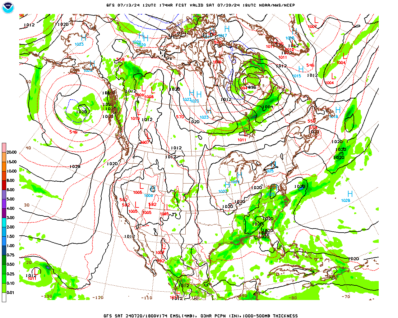
Then this guidance for Saturday from the GFS shows rain chances back up to 40-50%. And we have good agreement from the ECMWF. So I'll go with it. Rain chance stays at 40% or maybe 50% depending on reviewing the overall pattern in a minute here. High would be near 90 or upper 80's again, Low near 70.


Then going into the following week, looks like rain chances gradually settle down to just 20-30% isolated rain/thunderstorms in the 8-10 day range, Highs near 90, Lows near 70. Not going to include that in the official forecast above, but if you are enough to read the discussion, there you go, for a peek beyond next Saturday.
The tropics have become quiet for now. (Jinx?)

Our rainfall totals will average an inch or less over the next week. But we all know it's summer and it varies a lot more than these maps can pin down. At least it looks like later in the week we'll get back to more standard levels of summer heat and not the extra heat we've been having.


No comments:
Post a Comment