

FORECAST:
Tuesday (High 90, Low 72): Mostly cloudy and breezy with numerous rounds of showers and thunderstorms possible during the day - a few could become severe. Showers and thunderstorms are likely to become more widespread in the evening and night hours.
Wednesday (High 85, Low 69): Mostly sunny and breezy. An isolated shower is possible in the morning.
Thursday (High 89, Low 65): Sunny. Cool in the morning, not as hot in the afternoon.
EXTENDED OUTLOOK:
Friday (High 92, Low 67): Sunny.
Saturday (High 95, Low 69): Mostly sunny.
Sunday (High 94, Low 71): Partly cloudy with a 20% chance of showers/thunderstorms.
Monday (High 93, Low 72): Partly cloudy with a 30% chance of showers/thunderstorms.
BEACH FORECAST:
Tuesday (High 91, Low 80): Thunderstorms. Dangerous rip currents.
Wednesday (High 90, Low 77): Showers likely. Dangerous rip currents.
Thursday (High 92, Low 76): Partly cloudy. Scattered showers and thunderstorms are possible.
Weekend (Highs in lower 90's, Lows in upper 70's): Partly cloudy with a 40% chance of scattered showers/thunderstorms.
PRONÓSTICO:
Martes (Máxima 90, Mínima 72): Mayormente nublado y ventoso, con numerosas rondas de lluvias y tormentas eléctricas posibles durante el día; algunas podrían volverse severas. Es probable que los lluvias y tormentas eléctricas se generalicen en las horas de la tarde y la noche.
Miércoles (Máxima 85, Mínima 69): Mayormente soleado y ventoso. Por la mañana es posible que se produzcan chubascos aislados.
Jueves (Máxima 89, Mínima 65): Soleado. Fresco por la mañana, no tan caluroso por la tarde.
PERSPECTIVA EXTENDIDA:
Viernes (Máxima 92, Mínima 67): Soleado.
Sábado (Máxima 95, Mínima 69): Mayormente soleado.
Domingo (Máxima 94, Mínima 71): Parcialmente nublado con un 20 % de probabilidad de lluvias/tormentas eléctricas.
Lunes (Máxima 93, Mínima 72): Parcialmente nublado con un 30% de probabilidad de lluvias/tormentas eléctricas.
PREVISIÓN DE LA PLAYA:
Martes (Máxima 91, Mínima 80): Tormentas eléctricas. Peligrosas corrientes de resaca.
Miércoles (Máxima 90, Mínima 77): Lluvias probables. Peligrosas corrientes de resaca.
Jueves (Máxima 92, Mínima 76): Parcialmente nublado. Es posible que se produzcan lluvias y tormentas aisladas.
Fin de Semana (Máximas en los 90 grados inferiores, Mínimas en los 70 grados superiores): Parcialmente nublado con un 40 % de probabilidad de lluvias/tormentas eléctricas dispersas.
DISCUSSION:
Overall skies were partly to mostly sunny in Cullman today, but we had a few clouds increasing in the afternoon, and by the time I'm writing this at 6:42 PM we have a thunderstorm in the vicinity. The High was 95, and the Low was 70. Which is a bit toastier than the computer forecast models expected. So will take that into account for this forecast package. Mainly doing this forecast at the request of somebody I know who has to have surgery and is a little concerned about the hurricane remnants. But I guess a forecast a day is not a bad idea in this pattern anyway.


We've got several showers and thunderstorms this evening. The main action is out in Southern Arkansas and Northern Louisiana, also some in East Texas, where the remnants of Hurricane Beryl are winding their way through. They've had some flash flooding issues and also a few tornadoes. Let's see how many have been confirmed today.
Pause forecast, severe weather going on.
Okay, it is now 7:27 PM CDT. And that severe thunderstorm actually tore some siding off the house I'm currently staying in. We just got a big gust of wind, and a huge piece of siding tore off and started knocking against the window. That'll get a guy's attention . . .
And then my weather radio actually went off (for the first time in a while for any warnings, nice to have it working again) for the Cullman/Morgan County warning just a couple minutes later. I met a new neighbor, who impulsively ripped the piece of siding the rest of the way off, thinking it was bothering me and that he was doing me a favor. I do appreciate the intentions, but he really didn't have to do that.
The whole thing shook me up because last year I got hit with a summer storm that nearly started an electrical fire. There was a warning out on it ahead of time, but I missed it because the transmitter was down, and I'd fallen asleep, forgot to set weather radio to another channel.
It shook the cats up a little too. But all is well except some of the siding got ripped off. And that's really nothing to sweat.
So let's get on with the rest of the weather.

Well this map has been updated since I was originally going to post it. I was going to notice how we had nine tornado reports out West from the remnants of Hurricane Beryl. But now we have a report of wind damage near Falkville in Morgan County, where a tree and power line were reported down along West Lacon Road and Burney Road. And there were a few more trees down in that general area. Plus in Colbert County, at Littleville, a tree was reported down along Ligon Springs Road.
And this just came in from South Vinemont in Cullman County, a tree was reported down along County Road 1386.


And you can see our thunderstorms really well on satellite imagery. Out in Louisiana and Arkansas they are dealing with showers and thunderstorms with those tropical rain bands. Those can produce flash flooding and isolated tornadoes.


Our stalled front is now along the Tennessee/Kentucky state line. Another front runs through the Plains and Midwest. And then we have the hurricane remnants that we've already mentioned.
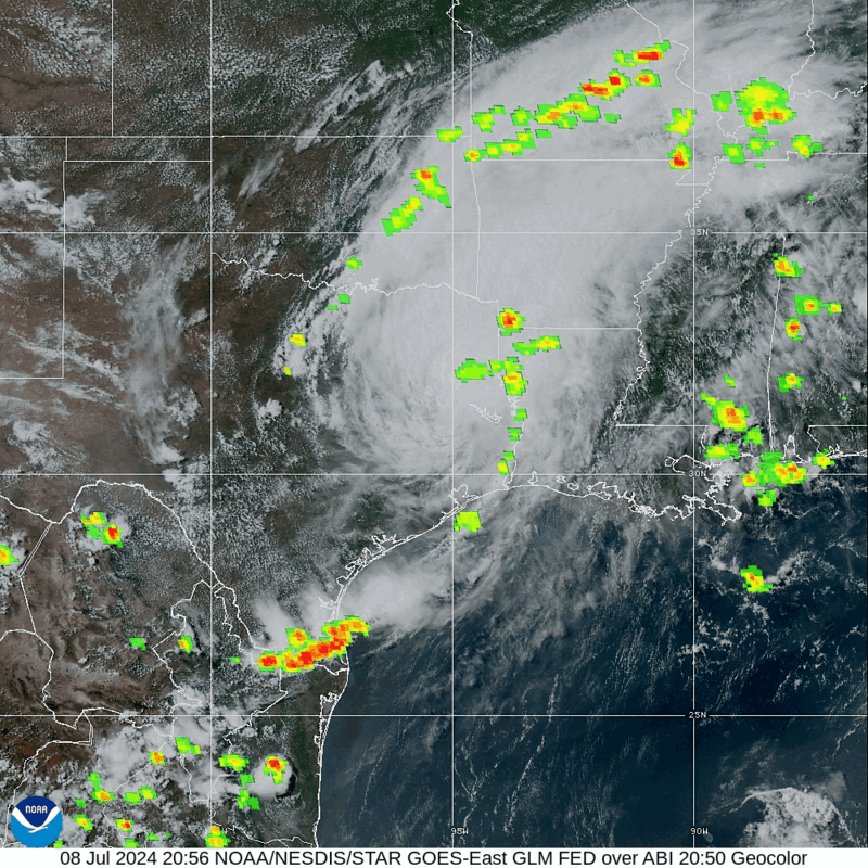

And it sure looks like this remnant Low is going to pass well to our North.


The Storm Prediction Center keeps the risk for isolated tornadoes in Central and Northern parts of Tennessee mostly, although places like Jackson and Southwest TN also have to keep an eye on it. The higher probabilities are up in Kentucky and clipping states like Missouri, Illinois, and Indiana. And even that's just a general 5% risk for isolated tornadoes. That's pretty standard with the remains of a tropical cyclone.


So tomorrow looks like it will feature about a 50/50 shot of rain, mostly cloudy and breezy. Might as well say "likely" showers and thunderstorms in the evening going into the night hours. Look for a High near 90, Low tonight about 70 or so. We'll have to watch for any stronger storms reaching severe limits and doing minor wind damage, more than we had any concern for that today. But it looks like we'll be on the Southeast side of the remnant Low formerly known as Tropical Cyclone Beryl.

The NAM shows a lot clearer position for that this go-round.
And usually to get the isolated tornadoes you need to be more on the East/Northeast side of those spiral bands. So the risk for any severe weather in far Southern Tennessee into North Alabama is probably going to be from damaging straight-line winds. These things can be a close call sometimes.


Thursday we get in a dry slot. Excuse me, this is Wednesday we're looking at. We could still see a stray shower in the morning, but overall a mostly sunny day, High only about 85, mid-80's, the Low near 70 or maybe dipping to about 69. It'll still be breezy.


Sunny conditions again Thursday with high pressure firmly in place. The High will struggle to rebound even to 90 degrees, and we'll have a morning Low in the mid-60's. So that will be a relief for a lot of us.


And it looks like we'll continue to enjoy that drier air on Friday. High should only get into the lower 90's and the morning Low in about the mid-to-upper-60's. So we've got some cool mornings on tap here. Mostly sunny skies Friday, little or no rain around.


And the latest global model guidance keeps us dry again on Saturday even though we start to get a little more wind flow from the Gulf of Mexico. High in mid-90's, Low of about 70.


Similar temperatures for Sunday but bringing back that minimal 20% rain chance.


Then a 30% chance for widely scattered showers and thunderstorms makes sense for Monday, with a High in the lower-to-mid-90's and a Low in the lower 70's.

Looks like our neighbors to the North and West get the heavy rains from the hurricane remnants. Around here it'll stay hit-or-miss with most of us getting amounts well under a half-inch, many of us probably seeing less than a quarter-inch of rain over the next seven days. But you know how summer goes. And especially with a tropical system nearby, even if we escape direct impacts from its rain bands. Would not be surprised to see somewhere get hit with some really heavy rain and then over in the next county, absolutely nothing, tomorrow. Then we get a dry spell most of Wednesday through probably Saturday. Then back to the typical summer pattern.
Just on the chance anyone reading this gets a Severe Thunderstorm Warning or Tornado Warning out of tomorrow/tomorrow night's weather, remember the basic idea: Get into a small central room (with no windows) on the lowest floor of a sturdy house or other strong building. You don't need to try to shelter in a mobile home during severe weather.
Hopefully our storms around here will stay under severe limits, but after this evening and the tropical remnants being a little too close for comfort, I guess I'm just playing it safe and reminding people. Somebody in Tennessee could draw the short straw and actually get a tornado tomorrow or tomorrow night. The chance is pretty low, but I'd still respect it.
And then enjoy the few days of a lot lower humidity. The rest of this month will probably be cooking much of the time. I don't think anybody expected this summer to be a mild one.


No comments:
Post a Comment