Monday (High 89, Low 68): Sunny. Low humidity.
Tuesday (High 91, Low 66): Mostly sunny. Low humidity.
Wednesday (High 92, Low 69): Partly cloudy. Isolated showers and thunderstorms are possible.
Independence Day (High 94, Low 73): Partly cloudy with a 30% chance of showers/thunderstorms.
Friday (High 93, Low 73): Partly cloudy with a 30% chance of showers/thunderstorms.
Saturday (High 92, Low 72): Partly cloudy with a 30% chance of showers/thunderstorms.
Sunday (High 92, Low 71): Partly cloudy witha 20% chance of showers/thunderstorms.
This boundary that I guess I have to call a cold front, even though the term sounds so ridiculous right now, is going to finish passing through our area and down to the Gulf Coast.
And tomorrow should be a sunny day with a High of about 88 or 89, Low of about 68 or 69 tonight/in the morning. And it may be a little breezy behind the front as that drier air comes in.
Tuesday looks mostly sunny with high pressure in place, and the air still pretty dry, allowing us to cool to about the mid-60's in the morning actually, then warm to about 90 degrees in the afternoon. So like I said, "cold fronts" this time of year don't do a whole lot for us.
It'll really be a nice couple of mornings though if you get up to do stuff like walking the dog before work or whatever.
Looks like moisture levels will return to normal on Wednesday, a High of 90 or so, Low back up near 70, a mix of sun and clouds and that typical minimal 20% chance of isolated rain.
Models continue to show an uptick in moisture and rain chances for Thursday, the 4th of July, but I'm only going to bump the chance up to 30%. It's basically just a matter of the high pressure moving to the East and allowing more moisture in, so I think the coverage of the isolated showers will only increase a little bit. High should be more toward the mid-90's, the Low in the lower 70's. So you could see a shower or thunderstorm while doing fireworks or whatever, but the chance is not especially high for this time of year, pretty typical.
These latest model runs are making it look more like lower 90's than mid-90's, but it's a close call. Friday it looks like another day where the rain chance needs to be bumped up to 30% with a High in lower 90's, Low in lower 70's.
Saturday and Sunday, rain chances staying in 20-30% range I think, Highs in lower 90's, Lows in lower 70's.
The tropics are the big story right now. I was just going to do this once every week or so, but boy, the tropics have fired up. That depression heading for Mexico has just strengthened tonight into Tropical Storm Chris. Hurricane Beryl is getting ready to do what could be really significant damage to the Windward Islands. And behind those two, we have another area of low pressure several hundred miles Southwest of the Cabo Verde Islands. It will probably be a tropical depression by about mid-week, and people in the Lesser Antilles at least need to watch and see what it does.
And wow, Tropical Storm Chris has already moved inland, made landfall at Vercruz, Mexico.
So we can cross that one off the list. It's already inland.
Meanwhile Hurricane Beryl is making weather history tonight as it gets ready to hit the Windward Islands with sustained winds of 130 miles per hour.
And based on the forecast track, A Tropical Storm Watch is already in effect for Southern parts of the Dominican Republic and Haiti. It may pass close enough to bring tropical storm effects to those places. Nothing issued for Jamaica yet, but it looks to maintain hurricane strength by the time it gets there on Wednesday. And then late this week it will probably affect the Yucatan Peninsula there in Central America before weakening to a tropical storm. Then we'll see what happens when it gets into the Southwestern Gulf of Mexico, if this forecast track verifies. This is definitely a storm that will go down in future meteorology textbooks as an anomaly. The ocean temperatures have been crazy-high this year. But everyone seems surprised by things ramping up like this so early in the season anyway. Like in theory we knew it was going to be an active season, but still, you never see this, a major hurricane forming that far East before we even get into July.
And we are into July now since it is after Midnight. It is now Monday July 1st.
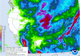
Our rainfall totals around here will mostly stay under a half-inch, maybe amounts closer to an inch for next seven days along and North of Tennessee border. But these estimates are not always as reliable in summer because our showers and storms are so random. Or at least the science struggles to figure out the mesoscale features that cause them from day to day, where and when it'll rain or blow up a storm.
Edit 1:08 PM July 1 - This post originally contained a lot more personal asides and crass juvenile humor that I decided was not appropriate after sobering up, so to speak. So I cut it out and mainly stuck to the weather. If you read the original scatterbrained version, you have my sympathies . . . vaguely at least.


No comments:
Post a Comment