FORECAST:
Sunday (High 84, Low 73): Mostly cloudy, also periods of patchy fog possible. Showers and thunderstorms are likely, and some may produce heavy rainfall or even pose a risk for flash flooding.
Monday (High 87, Low 72): Mostly cloudy, also patchy fog possible in the morning. Numerous rounds of showers and thunderstorms are possible, and some may still produce heavy rainfall.
Tuesday (High 91, Low 71): Partly to mostly cloudy, seasonably hot and humid. Scattered showers and thunderstorms are possible.
EXTENDED OUTLOOK:
Wednesday (High 94, Low 72): Partly cloudy with a 30% chance of showers/thunderstorms.
Thursday (High 96, Low 73): Mostly sunny with a 20% chance of showers/thunderstorms.
Friday (High 94, Low 72): Partly cloudy with a 20% chance of showers/thunderstorms.
Saturday (High 92, Low 72): Partly cloudy with a 30% chance of showers/thunderstorms.
BEACH FORECAST:
Sunday (High 88, Low 80): Showers and thunderstorms likely.
Monday (High 88, Low 79): Mostly cloudy with numerous rounds of showers and thunderstorms possible.
Tuesday (High 89, Low 79): Mostly cloudy with numerous rounds of showers and thunderstorms possible.
Rest of Week (Highs ~90, Lows ~80): Partly cloudy with a 40% chance of scattered showers and thunderstorms.
PRONÓSTICO:
Domingo (Máxima 84, Mínima 73): Mayormente nublado, también es posible que haya períodos de niebla irregular. Es probable que haya lluvias y tormentas eléctricas, y algunas pueden producir fuertes lluvias o incluso representar un riesgo de inundaciones repentinas.
Lunes (Máxima 87, Mínima 72): Mayormente nublado, también posible niebla irregular por la mañana. Es posible que se produzcan numerosas rondas de aguaceros y tormentas eléctricas, y algunas aún pueden producir fuertes lluvias.
Martes (Máxima 91, Mínima 71): Parcialmente o mayormente nublado, estacionalmente caluroso y húmedo. Es posible que se produzcan lluvias y tormentas aisladas.
PERSPECTIVA EXTENDIDA:
Miércoles (Máxima 94, Mínima 72): Parcialmente nublado con un 30% de probabilidad de lluvias/tormentas eléctricas.
Jueves (Máxima 96, Mínima 73): Mayormente soleado con un 20 % de probabilidad de lluvias/tormentas eléctricas.
Viernes (Máxima 94, Mínima 72): Parcialmente nublado con un 20 % de probabilidad de lluvias/tormentas eléctricas.
Sábado (Máxima 92, Mínima 72): Parcialmente nublado con un 30% de probabilidad de lluvias/tormentas eléctricas.
PRONÓSTICO DE LA PLAYA:
Domingo (Máxima 88, Mínima 80): Probables lluvias y tormentas eléctricas.
Lunes (Máxima 88, Mínima 79): Mayormente nublado con numerosas rondas de lluvias y tormentas eléctricas posibles.
Martes (Máxima 89, Mínima 79): Mayormente nublado con numerosas rondas de lluvias y tormentas eléctricas posibles.
Resto de la Semana (Máximas ~90, Mínimas ~80): Parcialmente nublado con un 40% de probabilidad de lluvias y tormentas eléctricas dispersas.
DISCUSSION:
It was another unusually mild day with periods of rain (off-and-on) in Cullman. We saw a High of 86 and Low of 72. Jasper had a High of 90 and Low of 73. Haleyville had a High of 86 and Low of 73. The sun was out at times during the day, but we've stayed in this unsettled pattern with a lot higher coverage of rain each day than usual in July.
Even here at about 6:45 PM CDT we have strong thunderstorms just North of Huntsville, also some heavier showers down around Tuscaloosa, and just a lot more rain on the board than you expect on a typical late July evening. This summer has been a weird one like last summer was, though I have to say I prefer this pattern to having windows blown out of buildings and a transformer knocked down, like we saw around here last summer during an August storm. This weird tropical rain forest phase is all right. We all know it could be worse. Usually we're cooking this time of year, and any rain we see is a cause for celebration.
Not to run this point in the ground, but our pattern lately has been anomalous. Right now we've got a surface frontal boundary bisecting the state of Alabama diagonally and affecting much of the Southeast region.
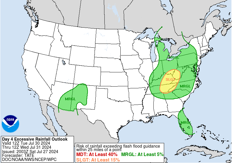
A lot more rain is on the way the next couple days, and we'll have to look out for some flash flooding issues here and there. The risk is not all that great, but it's enough to respect. Remember if you encounter flooded roadways or especially a bridge, stop and turn around . . . don't drown. You can't really tell how deep the water is or if a bridge may be washed out if the water is enough to cover the surface of the roadway. Once you're in it, it could be too late. So a little common sense will go a long way toward preventing any unfortunate incidents the next couple days if we do see instances of flash flooding.


Tomorrow is the most likely day for that of any day in this forecast period. Tomorrow into tomorrow night/maybe very early Monday morning. The GFS, which is the least aggressive model with it this go-round, still shows enough moisture to put rain chances up in the likely category, 60% or greater. And of course we could have some thunderstorms. Looks like a High of about 83-84, Low about 72-73, mostly cloudy skies.


For Monday going to bring the rain chance down to 50%. With a little more daytime heating, better chance at seeing thunderstorms or even an isolated strong thunderstorm. And again there is some risk of flash flooding, but I think that'll mainly be in the morning if we do see any issues. Tonight and again tomorrow through Sunday night, maybe early Monday, we will probably see periods of patchy fog thanks to several rounds of rain. So people who drive for a living may want to make a mental note of that. The model guidance isn't all that clear between the GFS/NAM/ECMWF, only showing the GFS above, but I think a 50% chance of rain is reasonable, and so is a High in the upper 80's, Low in the lower 70's.


It looks like Tuesday this odd pattern will finally start to come to an end. High pressure is building back out West and spreading in our general direction. So our rain chances will start to become more scattered in nature again, forecasting a 40% chance for Tuesday, and our heat levels will reach more standard levels for this time of year, or at least head back in that direction. Expecting a High near 90 and Low near 70 for Tuesday. And of course the humidity will make it feel closer to 100 degrees at times, when there's no rain and not much clouds, hottest times of the day. But that's nothing unusual for this time of year. It will actually start to feel like summer again, so hope people enjoyed the break.


Then rain chances come back to 30% for Wednesday which is more typical for this time of year. So any one spot's chances of getting a shower or thunderstorm will only be about 1-in-3, or 3 out of 10. It's about the same thing, just not if you do the exact math. But for all practical purposes, let's say a 1-in-3 chance at rain or a thunderstorm. No need getting nitpicky in the summer months. High should be in the lower 90's, Low in the lower 70's. One thing I will mention is that the heat indices could get up to 100-105 degrees at times due to the humidity. So the usual concerns with late July heat will return. Hope everyone enjoyed the rainforest feel for a while.


Then Thursday, the first of August, the models want to keep us hot and dry. I mean we'll still be humid, but rain chances really not showing up via the GFS (shown above) or the ECMWF (which I'll just let you imagine since it's summertime, and it looks about the same, just a different color scheme to show us dry and rain elsewhere in the country). Will keep a 20% chance of rain in there out of respect for climatology, but should be a mostly sunny day and hot. The actual High temperature should reach the mid-90's, and it wouldn't surprise me at all to see Heat Indices around here reach the 105 degree mark thanks to the humidity. The Low should be in the lower 70's.
Looks like the high pressure shifts down into the Gulf of Mexico on Friday. Looks like rain chance stays minimal, about 20%, so a 1-in-5 chance of any one spot getting wet, pretty standard for late July/early August. High should be in the lower-to-mid-90's, Low in the lower 70's.
That high pressure continues to retreat a little on Saturday, enough it might justify raising our rain chance back to 30% around here.
Especially since it looks like we'll have a stationary front parked roughly along the Kentucky/Tennessee state line. That could be a focus for showers and storms up that way, and then sometimes we get the leftovers from such systems. But rain should stay widely scattered, and we'll probably see a High more back toward the lower 90's again, Low still in the lower 70's.
Now there is something to watch in the tropics over the next several days, as a weak disturbance in the Central Tropical Atlantic is expected to interact with a tropical wave. When this system reaches the Leeward Islands or Greater Antilles about midweek, it may form into a tropical depression.
We do have some risk for flash flooding around here before the rain chances return to seasonal levels, the main chance coming tomorrow and tomorrow night through early Monday. And then you can see where the chances fizzle down quickly after that and shift to other parts of the country.
Overall we'll see about an inch of average rainfall totals over the next week. A few places might see more like two inches, and that is more likely in Northeast Alabama up into adjacent parts of Tennessee, if you had to bet on anywhere getting heavier rain. But I wouldn't bet on it in summertime around here.


No comments:
Post a Comment